
Scotland - Edinburgh, by Georg Braun & Frans Hogenberg. 1582
The item displayed on this page has been sold. However, we have a similar map in stock:
Edinburgh by Georg Braun & Frans Hogenberg 1582
Edenburg - Edenburgum, Scotiae Metropolis.
[Item number: 32196]
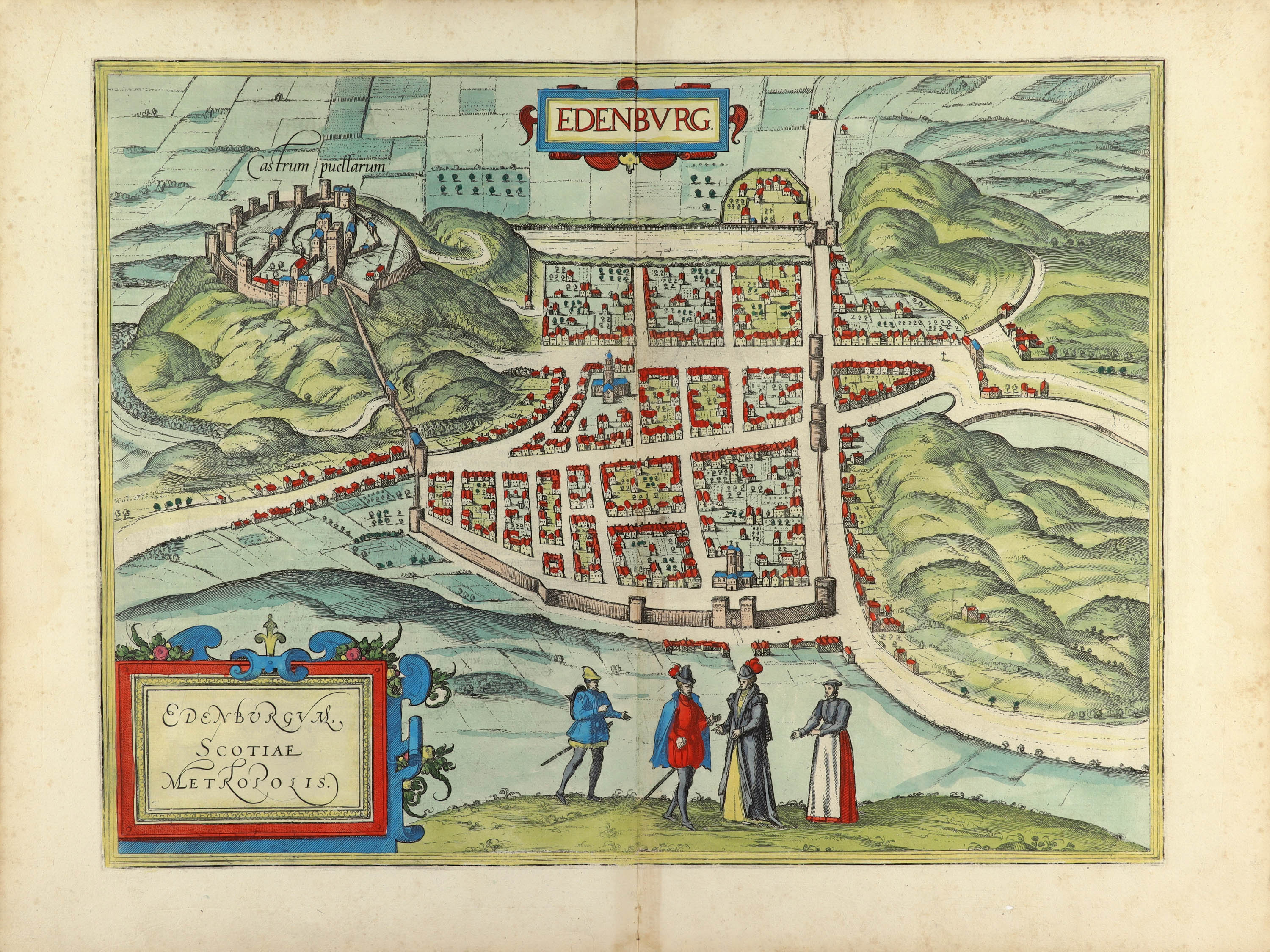

CARTOUCHE: Edinburgh is the capital of Scotland.
COMMENTARY BY BRAUN (on verso): "To the west of the city a mountain with a tall cliff rises up, upon which stands a castle, which is extremely secure due to its natural setting. On the side of the city to the east lies a majestic monastery to the Holy Cross, alongside it a royal palace set within an exceedingly charming garden. There are two large streets in this city, one that is paved with ashlar stone, leading from the Maidens' Castle to the monastery and to the royal palace, and the other is the highway. From the highway running from north to south countless smaller roads branch off, all of which are lined with very tall buildings."
Edinburgh is shown in plan view from the south, in the foreground are two figures wearing the typical style of dress of the nobility during the time of Mary, Queen of Scots. Perched atop the Castle Rock is Edinburgh Castle, indicated here as Castrum puellarum, or "Maidens' Castle". The origins of this designation are not known. According to one legend it can be traced back to a tradition among the Picts of holding virgins captive in the castle. Other sources refer to a legend claiming that princesses were able to live there in safety. It is also the place where King Malcolm III's widow, later St Margaret of Scotland, allegedly resided in the 11th century. The upper, horizontal thoroughfare, the High Street (later called the Royal Mile), which leads from the Castle Rock via the Gothic church of St Giles and the town gate in the east to Holyrood abbey, can readily be identified. The guesthouse of the abbey was transformed in the 16th century into the official residence of the British Monarchy in Scotland, the Palace of Holyroodhouse. Due to a burgeoning population Edinburgh's buildings had as many as 12 floors. Contemporary accounts tell of the miserable hygienic conditions that prevailed there and the resulting spread of disease. Around 1550 the town had 15,000 inhabitants; today 435,000 people live in Scotland's capital.
The engraving was made after a woodcut by Raphael Holinshead, 1574. (Taschen)
Braun G. & Hogenberg F. and the Civitates Orbis Terrarum.
The Civitates Orbis Terrarum, also known as the 'Braun & Hogenberg', is a six-volume town atlas and the most excellent book of town views and plans ever published: 363 engravings, sometimes beautifully coloured. It was one of the best-selling works in the last quarter of the 16th century. Georg Braun, a skilled writer, wrote the text accompanying the plans and views on the verso. Many plates were engraved after the original drawings of a professional artist, Joris Hoefnagel (1542-1600). The first volume was published in Latin in 1572 and the sixth in 1617. Frans Hogenberg, a talented engraver, created the tables for volumes I through IV, and Simon van den Neuwel made those for volumes V and VI. Other contributors were cartographers Daniel Freese and Heinrich Rantzau, who provided valuable geographical information. Works by Jacob van Deventer, Sebastian Münster, and Johannes Stumpf were also used as references. Translations appeared in German and French, making the atlas accessible to a broader audience.
Since its original publication of volume 1 in 1572, the Civitates Orbis Terrarum has left an indelible mark on the history of cartography. Seven more editions followed the first volume in 1575, 1577, 1582, 1588, 1593, 1599, and 1612. Vol.2, initially released in 1575, saw subsequent editions in 1597 and 1612. The subsequent volumes, each a treasure trove of historical insights, graced the world in 1581, 1588, 1593, 1599, and 1606. The German translation of the first volume, a testament to its widespread appeal, debuted in 1574, followed by the French edition in 1575.
Several printers were involved: Theodor Graminaeus, Heinrich von Aich, Gottfried von Kempen, Johannis Sinniger, Bertram Buchholtz, and Peter von Brachel, all of whom worked in Cologne.
Georg Braun (1541-1622)
Georg Braun, the author of the text accompanying the plans and views in the Civitates Orbis Terrarum, was born in Cologne in 1541. After his studies in Cologne, he entered the Jesuit Order as a novice, indicating his commitment to learning and intellectual pursuits. In 1561, he obtained his bachelor's degree; in 1562, he received his Magister Artium, further demonstrating his academic achievements. Although he left the Jesuit Order, he continued his studies in theology, gaining a licentiate in theology. His theological background likely influenced the content and tone of the text in the Civitates Orbis Terrarum, adding a unique perspective to the work.
Frans Hogenberg (1535-1590)
Frans Hogenberg was a Flemish and German painter, engraver, and mapmaker. He was born in Mechelen as the son of Nicolaas Hogenberg.
By the end of the 1560s, Frans Hogenberg was employed upon Abraham Ortelius's Theatrum Orbis Terrarum, published in 1570; he is named an engraver of numerous maps. In 1568, he was banned from Antwerp by the Duke of Alva and travelled to London, where he stayed a few years before emigrating to Cologne. He immediately embarked on his two most important works, the Civitates, published in 1572 and the Geschichtsblätter, which appeared in several series from 1569 until about 1587.
Thanks to large-scale projects like the Geschichtsblätter and the Civitates, Hogenberg's social circumstances improved with each passing year. He died as a wealthy man in Cologne in 1590.
Edenburg - Edenburgum, Scotiae Metropolis.
Item Number: 26787 Authenticity Guarantee
Category: Antique maps > Europe > British Isles - Cities
Old, antique map - Bird's-eye plan of Edinburgh, by Georg Braun and Frans Hogenberg.
Date of the first edition: 1581
Date of this map: 1582
Copper engraving, printed on paper.
Size (not including margins): 34.5 x 46cm (13.5 x 17.9 inches)
Verso text: German
Condition: Excellent.
Condition Rating: A+
References: Van der Krogt 4, #1185, State 1; Fauser, #3417; Taschen, Br. Hog., p.205.
From: Contrafactur und Beschreibung von den vornembsten Stetten der Welt. Liber Tertius. Köln, 1582. (Van der Krogt 4, 41:2.3)
CARTOUCHE: Edinburgh is the capital of Scotland.
COMMENTARY BY BRAUN (on verso): "To the west of the city a mountain with a tall cliff rises up, upon which stands a castle, which is extremely secure due to its natural setting. On the side of the city to the east lies a majestic monastery to the Holy Cross, alongside it a royal palace set within an exceedingly charming garden. There are two large streets in this city, one that is paved with ashlar stone, leading from the Maidens' Castle to the monastery and to the royal palace, and the other is the highway. From the highway running from north to south countless smaller roads branch off, all of which are lined with very tall buildings."
Edinburgh is shown in plan view from the south, in the foreground are two figures wearing the typical style of dress of the nobility during the time of Mary, Queen of Scots. Perched atop the Castle Rock is Edinburgh Castle, indicated here as Castrum puellarum, or "Maidens' Castle". The origins of this designation are not known. According to one legend it can be traced back to a tradition among the Picts of holding virgins captive in the castle. Other sources refer to a legend claiming that princesses were able to live there in safety. It is also the place where King Malcolm III's widow, later St Margaret of Scotland, allegedly resided in the 11th century. The upper, horizontal thoroughfare, the High Street (later called the Royal Mile), which leads from the Castle Rock via the Gothic church of St Giles and the town gate in the east to Holyrood abbey, can readily be identified. The guesthouse of the abbey was transformed in the 16th century into the official residence of the British Monarchy in Scotland, the Palace of Holyroodhouse. Due to a burgeoning population Edinburgh's buildings had as many as 12 floors. Contemporary accounts tell of the miserable hygienic conditions that prevailed there and the resulting spread of disease. Around 1550 the town had 15,000 inhabitants; today 435,000 people live in Scotland's capital.
The engraving was made after a woodcut by Raphael Holinshead, 1574. (Taschen)
Braun G. & Hogenberg F. and the Civitates Orbis Terrarum.
The Civitates Orbis Terrarum, also known as the 'Braun & Hogenberg', is a six-volume town atlas and the most excellent book of town views and plans ever published: 363 engravings, sometimes beautifully coloured. It was one of the best-selling works in the last quarter of the 16th century. Georg Braun, a skilled writer, wrote the text accompanying the plans and views on the verso. Many plates were engraved after the original drawings of a professional artist, Joris Hoefnagel (1542-1600). The first volume was published in Latin in 1572 and the sixth in 1617. Frans Hogenberg, a talented engraver, created the tables for volumes I through IV, and Simon van den Neuwel made those for volumes V and VI. Other contributors were cartographers Daniel Freese and Heinrich Rantzau, who provided valuable geographical information. Works by Jacob van Deventer, Sebastian Münster, and Johannes Stumpf were also used as references. Translations appeared in German and French, making the atlas accessible to a broader audience.
Since its original publication of volume 1 in 1572, the Civitates Orbis Terrarum has left an indelible mark on the history of cartography. Seven more editions followed the first volume in 1575, 1577, 1582, 1588, 1593, 1599, and 1612. Vol.2, initially released in 1575, saw subsequent editions in 1597 and 1612. The subsequent volumes, each a treasure trove of historical insights, graced the world in 1581, 1588, 1593, 1599, and 1606. The German translation of the first volume, a testament to its widespread appeal, debuted in 1574, followed by the French edition in 1575.
Several printers were involved: Theodor Graminaeus, Heinrich von Aich, Gottfried von Kempen, Johannis Sinniger, Bertram Buchholtz, and Peter von Brachel, all of whom worked in Cologne.
Georg Braun (1541-1622)
Georg Braun, the author of the text accompanying the plans and views in the Civitates Orbis Terrarum, was born in Cologne in 1541. After his studies in Cologne, he entered the Jesuit Order as a novice, indicating his commitment to learning and intellectual pursuits. In 1561, he obtained his bachelor's degree; in 1562, he received his Magister Artium, further demonstrating his academic achievements. Although he left the Jesuit Order, he continued his studies in theology, gaining a licentiate in theology. His theological background likely influenced the content and tone of the text in the Civitates Orbis Terrarum, adding a unique perspective to the work.
Frans Hogenberg (1535-1590)
Frans Hogenberg was a Flemish and German painter, engraver, and mapmaker. He was born in Mechelen as the son of Nicolaas Hogenberg.
By the end of the 1560s, Frans Hogenberg was employed upon Abraham Ortelius's Theatrum Orbis Terrarum, published in 1570; he is named an engraver of numerous maps. In 1568, he was banned from Antwerp by the Duke of Alva and travelled to London, where he stayed a few years before emigrating to Cologne. He immediately embarked on his two most important works, the Civitates, published in 1572 and the Geschichtsblätter, which appeared in several series from 1569 until about 1587.
Thanks to large-scale projects like the Geschichtsblätter and the Civitates, Hogenberg's social circumstances improved with each passing year. He died as a wealthy man in Cologne in 1590.
Related items

Brightstowe, Vulgo; Quondam Venta, Florentissimum. 1616
Bristol, by Braun Georg & Hogenberg Frans
[Item number: 26909]
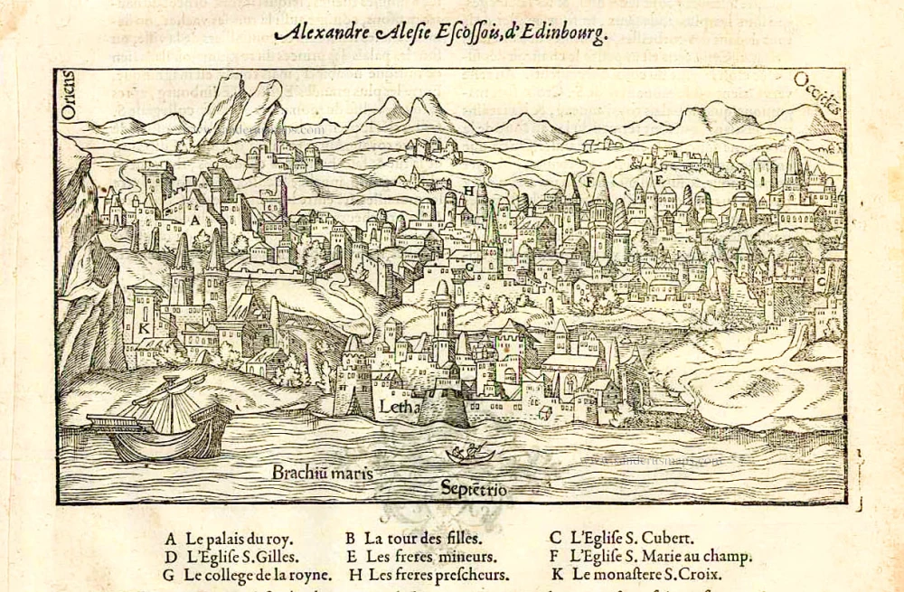
Alexandre Alesie Escossois, d'Edinbourg. 1575
Edinburgh, by François de Belleforest.
[Item number: 27164]
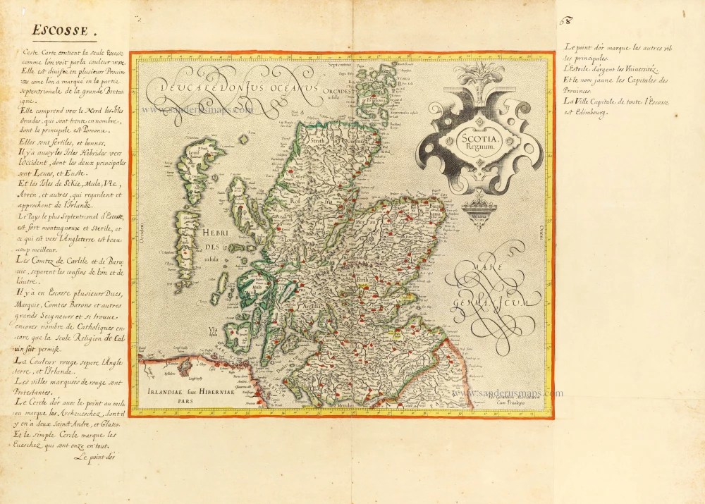
Scotia Regnum. c. 1610-1650
Scotland, by Gerard Mercator.
[Item number: 31015]