
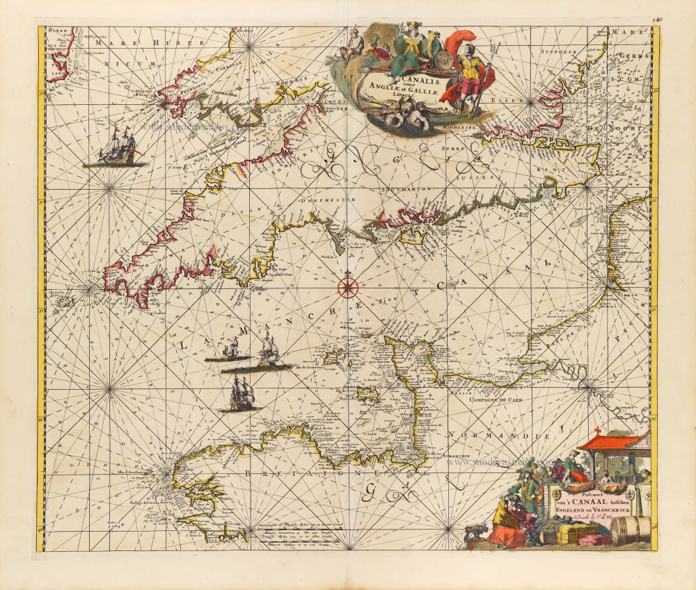
The English Channel, by Frederick de Wit. c. 1680


Frederick de Wit (1630-1706)
The engraver and map-seller, Frederick de Wit, was born in Gouda (Netherlands) in 1630 as a son of Hendrick Fredericksz de Wit. Through his marriage with Maria van der Waag of Amsterdam in 1661, he obtained citizenship of the city where he had been working since 1648 and where he became one of the most famous engravers of maps of the second half of the 17th century. Although De Wit was a Catholic, which meant that he was not favoured at the time by the city council, he was awarded the honour of being listed as one of the "excellent citizens" on the roll of the city council in the years 1694-1704. However, his name was not written in the Guild of St. Luke book before 1664. At that time, he lived on the Kalverstraat "in de Witte Pascaert", where he stayed until his death in 1706. His earliest dates on maps engraved are 1659 (Regni Daniae) and 1660 (World map).
Frederick de Wit published several world atlases, a sea atlas, and an atlas of the Netherlands.
The dating of the maps is difficult. However, as a privilege was granted in 1689, the annotation 'cum privilegio' marks an edition after 1688.
Around 1700, Frederick de Wit entered the market with a town atlas. He produced two volumes with a total of 260 plans and views. Most were printed from plates used for Janssonius and Blaeu town atlases.
After he died in 1706, his widow continued the shop until 1709. The plates and stock of De Wit's atlas were sold to Covens & Mortier in 1710, who sold the atlas for an extended period.
Canalis inter Angliae et Galliae Littera. - Pascaert van 't Canaal tusschen Engeland en Vranckryck.
Item Number: 29171 Authenticity Guarantee
Category: Antique maps > Europe > British Isles
Antique sea chart of the English Channel, by Frederick de Wit.
Title: Canalis inter Angliae et Galliae Littera. - Pascaert van 't Canaal tusschen Engeland en Vranckryck.
Gedruckt by F. de Wit.
Engraver: Romeyn de Hooghe.
Date of the first edition: 1671-76.
Date of this map: c. 1680.
Copper engraving, printed on paper.
Map size: 480 x 565mm (18.9 x 22.24 inches).
Sheet size: 540 x 630mm (21.26 x 24.8 inches).
Verso: Blank.
Condition: Original coloured, some reinforcements with archival paper at the back.
Condition Rating: A.
From: Orbis Maritimus ofte Zee Atlas. Amsterdam, F. de Wit, c. 1680.
Frederick de Wit (1630-1706)
The engraver and map-seller, Frederick de Wit, was born in Gouda (Netherlands) in 1630 as a son of Hendrick Fredericksz de Wit. Through his marriage with Maria van der Waag of Amsterdam in 1661, he obtained citizenship of the city where he had been working since 1648 and where he became one of the most famous engravers of maps of the second half of the 17th century. Although De Wit was a Catholic, which meant that he was not favoured at the time by the city council, he was awarded the honour of being listed as one of the "excellent citizens" on the roll of the city council in the years 1694-1704. However, his name was not written in the Guild of St. Luke book before 1664. At that time, he lived on the Kalverstraat "in de Witte Pascaert", where he stayed until his death in 1706. His earliest dates on maps engraved are 1659 (Regni Daniae) and 1660 (World map).
Frederick de Wit published several world atlases, a sea atlas, and an atlas of the Netherlands.
The dating of the maps is difficult. However, as a privilege was granted in 1689, the annotation 'cum privilegio' marks an edition after 1688.
Around 1700, Frederick de Wit entered the market with a town atlas. He produced two volumes with a total of 260 plans and views. Most were printed from plates used for Janssonius and Blaeu town atlases.
After he died in 1706, his widow continued the shop until 1709. The plates and stock of De Wit's atlas were sold to Covens & Mortier in 1710, who sold the atlas for an extended period.
Related items

Pas-kaert vande Canael, Tusschen Engelandt en Vrancryck Beginnende van C. de la Hague tot Heyssant, als mede van Poortland tot Lezard. 1697-1709
Bretagne and the Channel, by Van Keulen Johannes.
[Item number: 5406]

Sea chart
Pascaert van de Canael Tusschen Engelandt en Vrancryck, van Cales tot C. de la Hague, als meede van Doever tot Poortlant ... 1697-1709
Normandy by Van Keulen Johannes.
[Item number: 13639]

Pas-Caert van de Canael, tusschen Engelandt en Vranckryck, van Pleymuyen tot aen de Sorlinges ... 1697-1709
The Channel, by Van Keulen Johannes.
[Item number: 14588]

Sarnia Insula, vulgo Garnsey: et Insula Caesarae, vernacule Jarsey 1645-48
The Channel Islands, by J. Blaeu.
[Item number: 24640]

Spectacular 'Romain de Hooghe' map
Carte Nouvelle des Costes de Hollande, Zeelande, Flandre, Picardie, & Normandie ... Chez Pierre Mortier, 1693. 1700
Sea chart of the Channel - Flanders (Vlaanderen) - Zeeland, by Pieter Mortier.
[Item number: 27176]

Carte de la Manche. c. 1705
Channel, by Pierre Mortier.
[Item number: 28001]
Canalis inter Angliae et Galliae Littera. - Pascaert van 't Canaal tusschen Engeland en Vranckryck. c. 1680
The English Channel, by Frederick de Wit.
[Item number: 29171]

Carte de la Manche. 1692
Channel by N. Sanson, so-called published by Hubert Jaillot. (Pirated edition by Pierre Mortier).
[Item number: 31172]

Nieuwe Zeekaart van t' Eerste Gedeelte van t' Canaal Tusschen Engeland en Vrankrijk. [Title also in French, English, Spanish, and Italian] 1704
Sea chart of the Channel by Gerard van Keulen.
[Item number: 31427]

Carte Réduite des Isles Britanniques en cinq feuilles Pour servir aux vaisseaux du Roy. 1765
Sea chart of the Channel - between France and England & Wales, by Jacques Nicolas Bellin.
[Item number: 31445]