
Ireland by Petrus Schenk. c. 1700


The Danckerts Family.
The Danckerts family of Amsterdam was one of the best-known print and map sellers in 17th century Amsterdam. Their business activity covered a vast period, from ca. 1633. From 1669 until 1701, father Justus and his sons had their shop in the ‘Calverstraet in de Danckbaerheyt’.
Cornelis Danckerts (1561-1631) was a printseller born in Amsterdam and active in Antwerp.
Cornelis Danckerts, the elder (1603-1656) was an engraver and publisher in Amsterdam and Nieuwendijk. Son of Cornelis (above), whom he succeeded in 1631.
The house of Danckerts gained its greatest fame from Justus Danckerts (1635-1701 - son of Cornelis the elder) and his two sons, Theodorus and Cornelis. Dancker Danckerts (1634-1666), the elder brother of Justus, was known for his etchings of paintings, maps, and publications.
The grandfather, father, and sons were highly skilled and excellent artistic drafters and engravers. They are famous for the edition of their Atlas, which appeared from ca. 1686, and for several monumental and beautiful wall maps and views. However, compared with that published by the Blaeu's or Janssonius's, their cartographic work has attracted little attention and has never received proper recognition.
On 14 August 1684, Justus and his sons obtained the privilege from the States of Holland for their publications. In 1713, twelve years after Justus Danckerts, the heirs decided to sell part of the stock of maps and atlases and many copperplates. In 1727, after the death of the last surviving brother Theodorus, a final sale took place.
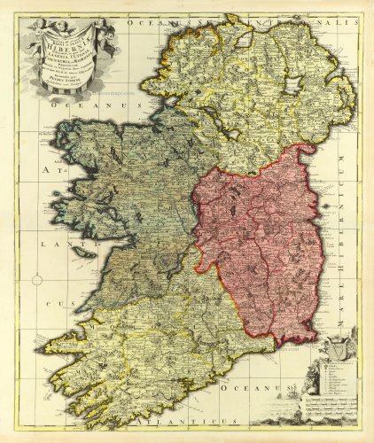
Novissima et accuratissima Regni et Insulae Hiberniae Delineatio in qua sund Lagenia, Ultonia, Connachia et Momonia . . .
Item Number: 32496 Authenticity Guarantee
Category: Antique maps > Europe > British Isles
Ireland by Petrus Schenk.
Title: Novissima et accuratissima Regni et Insulae Hiberniae Delineatio in qua sund Lagenia, Ultonia, Connachia et Momonia . . .
per Petrus Schenk Amstelodami cum Privilegio.
Date of the first edition: c. 1700.
Date of this map: c. 1700.
Copper engraving, printed on paper.
Image size: 590 x 490mm (23¼ x 19¼ inches).
Sheet size: 625 x 525mm (24½ x 20¾ inches).
Verso: Blank.
Condition: Original coloured, excellent.
Condition Rating: A+.
From: Atlas Contractus sive Mapparum Geographicarum Sansoniarum auctarum et correctarum Nova Congeries. Amsterdam, Petrus Schenk, c. 1700. (Koeman, Sche 2)
This rare map appears only in a few copies of this atlas.
The Danckerts Family.
The Danckerts family of Amsterdam was one of the best-known print and map sellers in 17th century Amsterdam. Their business activity covered a vast period, from ca. 1633. From 1669 until 1701, father Justus and his sons had their shop in the ‘Calverstraet in de Danckbaerheyt’.
Cornelis Danckerts (1561-1631) was a printseller born in Amsterdam and active in Antwerp.
Cornelis Danckerts, the elder (1603-1656) was an engraver and publisher in Amsterdam and Nieuwendijk. Son of Cornelis (above), whom he succeeded in 1631.
The house of Danckerts gained its greatest fame from Justus Danckerts (1635-1701 - son of Cornelis the elder) and his two sons, Theodorus and Cornelis. Dancker Danckerts (1634-1666), the elder brother of Justus, was known for his etchings of paintings, maps, and publications.
The grandfather, father, and sons were highly skilled and excellent artistic drafters and engravers. They are famous for the edition of their Atlas, which appeared from ca. 1686, and for several monumental and beautiful wall maps and views. However, compared with that published by the Blaeu's or Janssonius's, their cartographic work has attracted little attention and has never received proper recognition.
On 14 August 1684, Justus and his sons obtained the privilege from the States of Holland for their publications. In 1713, twelve years after Justus Danckerts, the heirs decided to sell part of the stock of maps and atlases and many copperplates. In 1727, after the death of the last surviving brother Theodorus, a final sale took place.
Related items

Irlandiae Regnum . 1623
Ireland (North + South) (2 maps), by G. Mercator.
[Item number: 2684]

De Noord-Oost zyde van Yerlandt van Caap de Hoorn-hout tot Hedehde-hout oock hoe 't van Schotlandt gestrekt leydt 1686
Ireland, by Doncker H.
[Item number: 13644]

Hibernia Regnum Vulgo Ireland. 1641
Ireland by Joannes Janssonius
[Item number: 26258]

Royaume d'Irlande divisé en ses quatre provences, et subdivisé en Comtés. 1776-79
Ireland by Francesco & Paolo Santini
[Item number: 26962]

Novissima ac Prae Caeteris Aliis Accuratissima Regni et Insulae Hiberniae Delineatio, in qua sunt Lagenia, Ultonia, Connachia, et Momonia Provinciae. c. 1691-97
Ireland by Frederik de Wit.
[Item number: 29565]

Irlanda. - [Above map :] Descrittione dell'Isola d'Irlanda 1590
Ireland, by Thomaso Porcacchi.
[Item number: 29734]

Eryn. Hiberniae, Britannicae Insulae, Nova Descriptio. Irlandt. 1595
Ireland by Abraham Ortelius.
[Item number: 30152]

Le Royaume d'Irlande Divisé en ses Provinces. Subdivisé en Shireries ou Comtés. 1692
Ireland by N. Sanson, so-called published by Hubert Jaillot. (Pirated edition by Pierre Mortier).
[Item number: 31171]

Rare first edition
Irlandiae Regnum. 1595
Ireland, by Gerard Mercator.
[Item number: 31428]

Hibernia 1618
Ireland by Petrus Bertius, published by Jodocus Hondius II.
[Item number: 31532]

Hibernia Septentr. in qua Ultonia Connatia. [in set with] Hibernia Austral. in qua Momonia Lagenia. 1618
Ireland by Petrus Bertius, published by Jodocus Hondius II.
[Item number: 31543]

Ireland. 1869
Satirical (anthropomorphic) map of Ireland.
[Item number: 32190]

Hiberniae Regnum tam in Praecipuas Ultoniae, Connaciae, Lageniae, et Momoniae c. 1705
Ireland by Nicolas Visscher II
[Item number: 32700]

Rare and important sea chart
Pas-caerte van Yrland, met Alle Zee-custen, Havenen, Ancker-plaetsen en droogten, daer rontsomme gelegen. 1666
Ireland by Joannes Van Loon.
[Item number: 32978]