
Ireland, by Doncker H. 1686

Hendrick Doncker (1625-1699)
Hendrick Doncker became a member of the bookseller's guild in 1647 and ran his shop successfully for fifty years. He was able to develop one of the most popular sets of maritime works published in Amsterdam during the Golden Age.
In 1651 he bought a house in the Nieuwe Brugsteeg in Amsterdam. It was called 'in 't Stuurmans gereetschap' (in the mariners' instruments) and stood opposite the house where Johannes van Keulen later settled.
Apart from the sea atlases, charts and pilot books, Hendrik Doncker published various editions of textbooks on the art of navigation.
After the death of Hendrick Doncker, the son, Hendrick II (c. 1664-c.1739), continued publishing the sea atlases Zeeatlas and Zeespiegel until 1708.
Doncker's charts were the most up-to-date in the second half of the 17th century. Although there is some similarity to those charts published by Van Loon, Goos, Lootsman, and Doncker, the latter's charts are original.
In 1655, Hendrick Doncker had begun with the publication of a pilot guide, the Lichtende Columne ofte Zeespiegel. In 1659 he published his first sea atlas, the Zee-Atlas of Waeter-waereld, with 19 maps. Between 1659 and 1669, he increased the number of charts from 19 to 30 and in 1669 he came with an edition containing 50, which was soon to be followed by an edition with large maps: the Nieuwe Groote Vermeerderde Zeeatlas, also with 50 charts. This beautiful atlas was reprinted and continually improved for more than 25 years. After the death of Hendrick Doncker in 1699, his son continued the publication and even enlarged and enhanced the sea-atlas.
De Noord-Oost zyde van Yerlandt van Caap de Hoorn-hout tot Hedehde-hout oock hoe 't van Schotlandt gestrekt leydt
Item Number: 13644 Authenticity Guarantee
Category: Antique maps > Europe > British Isles
Old, antique map of Ireland by Doncker H.
Title: De Noord-Oost zyde van Yerlandt van Caap de Hoorn-hout tot Hedehde-hout oock hoe 't van Schotlandt gestrekt leydt.
Oriented to the southwest.
Date: 1686.
Copper engraving, printed on paper.
Size (not including margins): 415 x 530mm (16.34 x 20.87 inches).
Verso: Blank.
Condition: Original coloured, excellent.
Condition Rating: A+.
From: Le Grand & Nouveau Miroir ou Flambeau, De la Mer contenant la description de toutes les costes Marines Occidentalled & Septentrionalles, . . . Traduit de Flaman en François par Paul Yvounet. A Amsterdam Chés Henri Donker, . . . l'An 1686.
Hendrick Doncker (1625-1699)
Hendrick Doncker became a member of the bookseller's guild in 1647 and ran his shop successfully for fifty years. He was able to develop one of the most popular sets of maritime works published in Amsterdam during the Golden Age.
In 1651 he bought a house in the Nieuwe Brugsteeg in Amsterdam. It was called 'in 't Stuurmans gereetschap' (in the mariners' instruments) and stood opposite the house where Johannes van Keulen later settled.
Apart from the sea atlases, charts and pilot books, Hendrik Doncker published various editions of textbooks on the art of navigation.
After the death of Hendrick Doncker, the son, Hendrick II (c. 1664-c.1739), continued publishing the sea atlases Zeeatlas and Zeespiegel until 1708.
Doncker's charts were the most up-to-date in the second half of the 17th century. Although there is some similarity to those charts published by Van Loon, Goos, Lootsman, and Doncker, the latter's charts are original.
In 1655, Hendrick Doncker had begun with the publication of a pilot guide, the Lichtende Columne ofte Zeespiegel. In 1659 he published his first sea atlas, the Zee-Atlas of Waeter-waereld, with 19 maps. Between 1659 and 1669, he increased the number of charts from 19 to 30 and in 1669 he came with an edition containing 50, which was soon to be followed by an edition with large maps: the Nieuwe Groote Vermeerderde Zeeatlas, also with 50 charts. This beautiful atlas was reprinted and continually improved for more than 25 years. After the death of Hendrick Doncker in 1699, his son continued the publication and even enlarged and enhanced the sea-atlas.
Related items

De Texel Stroom met de gaten vant Marsdiep. [On sheet with:] Caarte van De Mase ende het Goereesche Gat 1686
Texel & Maas, by Doncker H.
[Item number: 13738]
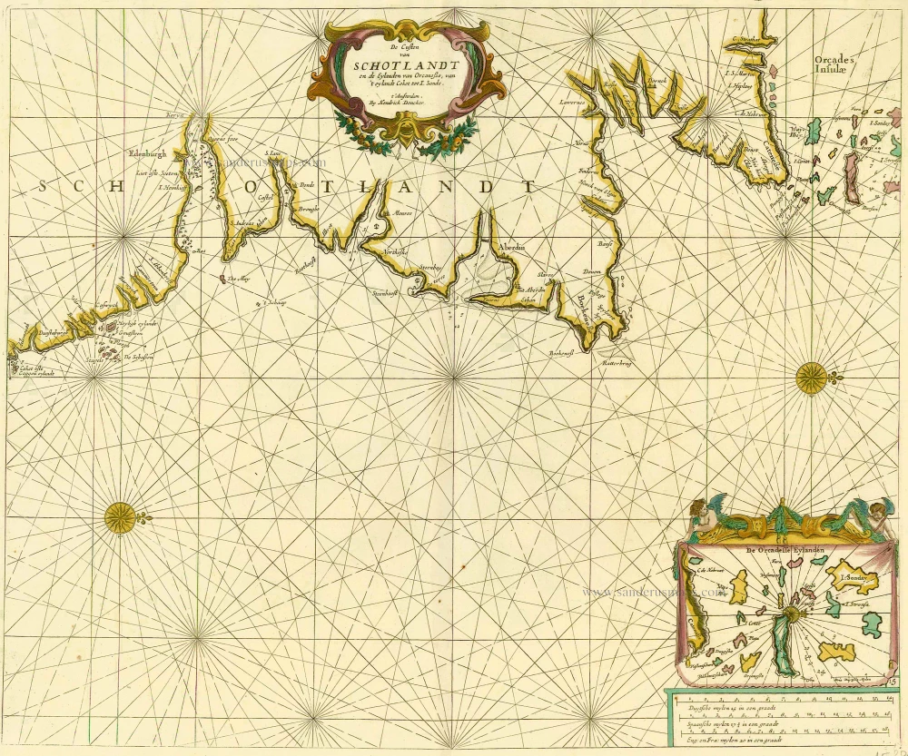
De Custen van Schotlandt en de Eylanden van Orcanese, van 't eylandt Coket tot I. Sande. 1686
Scotland and Orkney Islands, by Doncker H.
[Item number: 15386]

Canarische Eylanden Canaria Tenerifa, Forteventura etc. t' Amsterdam, 1686
Canary Islands, by Hendrick Doncker.
[Item number: 15419]
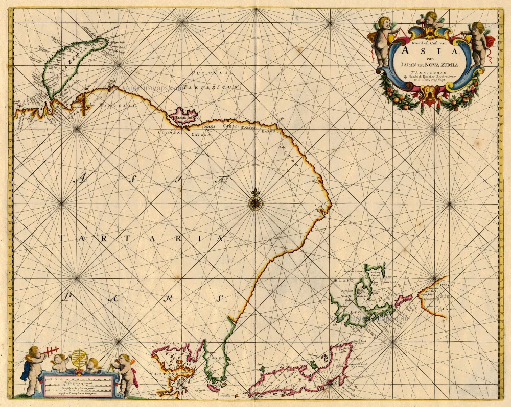
Noordoost Cust van Asia van Iapan tot Nova Zemla 1688
Northeast Asia, by Doncker H.
[Item number: 18466]

Barbarien tusschen C. de Tenes en C. de Rosa. t' Amsterdam, By Hendrick Doncker. 1664
Northern Africa, by Doncker H.
[Item number: 21375]

Hibernia Regnum Vulgo Ireland. 1641
Ireland by Joannes Janssonius
[Item number: 26258]

Royaume d'Irlande divisé en ses quatre provences, et subdivisé en Comtés. 1776-79
Ireland by Francesco & Paolo Santini
[Item number: 26962]

Novissima ac Prae Caeteris Aliis Accuratissima Regni et Insulae Hiberniae Delineatio, in qua sunt Lagenia, Ultonia, Connachia, et Momonia Provinciae. c. 1691-97
Ireland by Frederik de Wit.
[Item number: 29565]

Irlanda. - [Above map :] Descrittione dell'Isola d'Irlanda 1590
Ireland, by Thomaso Porcacchi.
[Item number: 29734]

Eryn. Hiberniae, Britannicae Insulae, Nova Descriptio. Irlandt. 1595
Ireland by Abraham Ortelius.
[Item number: 30152]

Galwaye [on sheet with] Dubline [and] Lymericke [and] Corcke. 1635
Dublin, Galway, Limerick & Cork by Georg Braun & Frans Hogenberg.
[Item number: 30541]

Le Royaume d'Irlande Divisé en ses Provinces. Subdivisé en Shireries ou Comtés. 1692
Ireland by N. Sanson, so-called published by Hubert Jaillot. (Pirated edition by Pierre Mortier).
[Item number: 31171]

Rare first edition
Irlandiae Regnum. 1595
Ireland, by Gerard Mercator.
[Item number: 31428]

Irlandiae Regnum. 1628.
Southern Ireland by Gerard Mercator.
[Item number: 31449]

Hibernia 1618
Ireland by Petrus Bertius, published by Jodocus Hondius II.
[Item number: 31532]

Media. 1618
Ireland - Meath by Petrus Bertius, published by Jodocus Hondius II.
[Item number: 31535]

Hibernia Septentr. in qua Ultonia Connatia. [in set with] Hibernia Austral. in qua Momonia Lagenia. 1618
Ireland by Petrus Bertius, published by Jodocus Hondius II.
[Item number: 31543]

Ireland. 1869
Satirical (anthropomorphic) map of Ireland.
[Item number: 32190]

Novissima et accuratissima Regni et Insulae Hiberniae Delineatio in qua sund Lagenia, Ultonia, Connachia et Momonia . . . c. 1700
Ireland by Petrus Schenk.
[Item number: 32496]

Hiberniae Regnum tam in Praecipuas Ultoniae, Connaciae, Lageniae, et Momoniae c. 1705
Ireland by Nicolas Visscher II
[Item number: 32700]

Rare and important sea chart
Pas-caerte van Yrland, met Alle Zee-custen, Havenen, Ancker-plaetsen en droogten, daer rontsomme gelegen. 1666
Ireland by Joannes Van Loon.
[Item number: 32978]