
Old, antique map of Chester by Braun & Hogenberg 1599


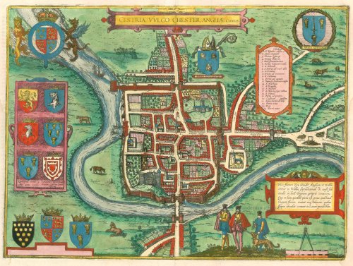

CARTOUCHE TOP: Cestria, in English Chester, a city in England.
CARTOUCHE BOTTOM: The River Dee divides England and Wales. It has its source in the north of Wales and flows into the sea called Tegaeus, in whose waters lives a specific type of fish that never swims up river, just as the salmon that swarm the river never venture into the aforesaid sea.
COMMENTARY BY BRAUN: "The name of the town founder is unknown, if one has seen the houses contructed from enormous stones, one believes that the city was the work of giants or the Romans, in any case not the English. One also finds inscribed ancient names, that of Julius Caesar among others. [...] The city has a hospital and quarantaine stations, nine parish churches and an attractive cathedral."
The schematic bird's-eye view shows the city from the south, ringed by a nearly square-shaped city wall. On top of the man-made knoll in the left foreground lies Chester Castle (20), a defensive fortification against Celtic assaults, which was erected following the Norman Conquest in 1066 to secure the nearby bridge (23) over the River Dee. Chester was founded two millennia ago as Castra Devana, serving a Roman Legion that was posted there to ward off the Celtic Welsh as an important harbour and defensive position. Following the withdrawal of the Romans, the Anglo-Saxons extended the walls in order to protect the city against incursions by the Danes. Fortified further during Norman times, Chester was intermittently the largest inland harbour in England, whose transhipment activities brought prosperity to the city. (Taschen)
Braun G. & Hogenberg F. and the Civitates Orbis Terrarum.
The Civitates Orbis Terrarum, also known as the 'Braun & Hogenberg', is a six-volume town atlas and the most excellent book of town views and plans ever published: 363 engravings, sometimes beautifully coloured. It was one of the best-selling works in the last quarter of the 16th century. Georg Braun, a skilled writer, wrote the text accompanying the plans and views on the verso. Many plates were engraved after the original drawings of a professional artist, Joris Hoefnagel (1542-1600). The first volume was published in Latin in 1572 and the sixth in 1617. Frans Hogenberg, a talented engraver, created the tables for volumes I through IV, and Simon van den Neuwel made those for volumes V and VI. Other contributors were cartographers Daniel Freese and Heinrich Rantzau, who provided valuable geographical information. Works by Jacob van Deventer, Sebastian Münster, and Johannes Stumpf were also used as references. Translations appeared in German and French, making the atlas accessible to a broader audience.
Since its original publication of volume 1 in 1572, the Civitates Orbis Terrarum has left an indelible mark on the history of cartography. Seven more editions followed the first volume in 1575, 1577, 1582, 1588, 1593, 1599, and 1612. Vol.2, initially released in 1575, saw subsequent editions in 1597 and 1612. The subsequent volumes, each a treasure trove of historical insights, graced the world in 1581, 1588, 1593, 1599, and 1606. The German translation of the first volume, a testament to its widespread appeal, debuted in 1574, followed by the French edition in 1575.
Several printers were involved: Theodor Graminaeus, Heinrich von Aich, Gottfried von Kempen, Johannis Sinniger, Bertram Buchholtz, and Peter von Brachel, all of whom worked in Cologne.
Georg Braun (1541-1622)
Georg Braun, the author of the text accompanying the plans and views in the Civitates Orbis Terrarum, was born in Cologne in 1541. After his studies in Cologne, he entered the Jesuit Order as a novice, indicating his commitment to learning and intellectual pursuits. In 1561, he obtained his bachelor's degree; in 1562, he received his Magister Artium, further demonstrating his academic achievements. Although he left the Jesuit Order, he continued his studies in theology, gaining a licentiate in theology. His theological background likely influenced the content and tone of the text in the Civitates Orbis Terrarum, adding a unique perspective to the work.
Frans Hogenberg (1535-1590)
Frans Hogenberg was a Flemish and German painter, engraver, and mapmaker. He was born in Mechelen as the son of Nicolaas Hogenberg.
By the end of the 1560s, Frans Hogenberg was employed upon Abraham Ortelius's Theatrum Orbis Terrarum, published in 1570; he is named an engraver of numerous maps. In 1568, he was banned from Antwerp by the Duke of Alva and travelled to London, where he stayed a few years before emigrating to Cologne. He immediately embarked on his two most important works, the Civitates, published in 1572 and the Geschichtsblätter, which appeared in several series from 1569 until about 1587.
Thanks to large-scale projects like the Geschichtsblätter and the Civitates, Hogenberg's social circumstances improved with each passing year. He died as a wealthy man in Cologne in 1590.
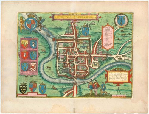
Cestria vulgo Chester, Angliae Civitas.
Item Number: 22186 Authenticity Guarantee
Category: Antique maps > Europe > British Isles
Bird's-eye plan of Chester, after a drawing by William Smith.
CARTOUCHE TOP: Cestria, in English Chester, a city in England.
CARTOUCHE BOTTOM: The River Dee divides England and Wales. It has its source in the north of Wales and flows into the sea called Tegaeus, in whose waters lives a specific type of fish that never swims up river, just as the salmon that swarm the river never venture into the aforesaid sea.
COMMENTARY BY BRAUN: "The name of the town founder is unknown, if one has seen the houses constructed from enormous stones, one believes that the city was the work of giants or the Romans, in any case not the English. One also finds inscribed ancient names, that of Julius Caesar among others. [...] The city has a hospital and quarantine stations, nine parish churches and an attractive cathedral."
The schematic bird's-eye view shows the city from the south, ringed by a nearly square-shaped city wall. On top of the man-made knoll in the left foreground lies Chester Castle (20), a defensive fortification against Celtic assaults, which was erected following the Norman Conquest in 1066 to secure the nearby bridge (23) over the River Dee. Chester was founded two millennia ago as Castra Devana, serving a Roman Legion that was posted there to ward off the Celtic Welsh as an important harbour and defensive position. Following the withdrawal of the Romans, the Anglo-Saxons extended the walls in order to protect the city against incursions by the Danes. Fortified further during Norman times, Chester was intermittently the largest inland harbour in England, whose transhipment activities brought prosperity to the city. (Taschen)
Date of the first edition: 1581
Date of this map: 1599
Copper engraving
Size: 33 x 44.5cm (12.9 x 17.4 inches)
Verso text: Latin
Condition: Excellent, superb old colour.
Condition Rating: A+
References: Van der Krogt 4, 874 State 1; Taschen, Braun and Hogenberg, p.205.
From: Civitates Orbis Terrarum. . Liber tertius. Köln, Bertram Buchholtz, 1599. (Koeman, B&H3)
CARTOUCHE TOP: Cestria, in English Chester, a city in England.
CARTOUCHE BOTTOM: The River Dee divides England and Wales. It has its source in the north of Wales and flows into the sea called Tegaeus, in whose waters lives a specific type of fish that never swims up river, just as the salmon that swarm the river never venture into the aforesaid sea.
COMMENTARY BY BRAUN: "The name of the town founder is unknown, if one has seen the houses contructed from enormous stones, one believes that the city was the work of giants or the Romans, in any case not the English. One also finds inscribed ancient names, that of Julius Caesar among others. [...] The city has a hospital and quarantaine stations, nine parish churches and an attractive cathedral."
The schematic bird's-eye view shows the city from the south, ringed by a nearly square-shaped city wall. On top of the man-made knoll in the left foreground lies Chester Castle (20), a defensive fortification against Celtic assaults, which was erected following the Norman Conquest in 1066 to secure the nearby bridge (23) over the River Dee. Chester was founded two millennia ago as Castra Devana, serving a Roman Legion that was posted there to ward off the Celtic Welsh as an important harbour and defensive position. Following the withdrawal of the Romans, the Anglo-Saxons extended the walls in order to protect the city against incursions by the Danes. Fortified further during Norman times, Chester was intermittently the largest inland harbour in England, whose transhipment activities brought prosperity to the city. (Taschen)
Braun G. & Hogenberg F. and the Civitates Orbis Terrarum.
The Civitates Orbis Terrarum, also known as the 'Braun & Hogenberg', is a six-volume town atlas and the most excellent book of town views and plans ever published: 363 engravings, sometimes beautifully coloured. It was one of the best-selling works in the last quarter of the 16th century. Georg Braun, a skilled writer, wrote the text accompanying the plans and views on the verso. Many plates were engraved after the original drawings of a professional artist, Joris Hoefnagel (1542-1600). The first volume was published in Latin in 1572 and the sixth in 1617. Frans Hogenberg, a talented engraver, created the tables for volumes I through IV, and Simon van den Neuwel made those for volumes V and VI. Other contributors were cartographers Daniel Freese and Heinrich Rantzau, who provided valuable geographical information. Works by Jacob van Deventer, Sebastian Münster, and Johannes Stumpf were also used as references. Translations appeared in German and French, making the atlas accessible to a broader audience.
Since its original publication of volume 1 in 1572, the Civitates Orbis Terrarum has left an indelible mark on the history of cartography. Seven more editions followed the first volume in 1575, 1577, 1582, 1588, 1593, 1599, and 1612. Vol.2, initially released in 1575, saw subsequent editions in 1597 and 1612. The subsequent volumes, each a treasure trove of historical insights, graced the world in 1581, 1588, 1593, 1599, and 1606. The German translation of the first volume, a testament to its widespread appeal, debuted in 1574, followed by the French edition in 1575.
Several printers were involved: Theodor Graminaeus, Heinrich von Aich, Gottfried von Kempen, Johannis Sinniger, Bertram Buchholtz, and Peter von Brachel, all of whom worked in Cologne.
Georg Braun (1541-1622)
Georg Braun, the author of the text accompanying the plans and views in the Civitates Orbis Terrarum, was born in Cologne in 1541. After his studies in Cologne, he entered the Jesuit Order as a novice, indicating his commitment to learning and intellectual pursuits. In 1561, he obtained his bachelor's degree; in 1562, he received his Magister Artium, further demonstrating his academic achievements. Although he left the Jesuit Order, he continued his studies in theology, gaining a licentiate in theology. His theological background likely influenced the content and tone of the text in the Civitates Orbis Terrarum, adding a unique perspective to the work.
Frans Hogenberg (1535-1590)
Frans Hogenberg was a Flemish and German painter, engraver, and mapmaker. He was born in Mechelen as the son of Nicolaas Hogenberg.
By the end of the 1560s, Frans Hogenberg was employed upon Abraham Ortelius's Theatrum Orbis Terrarum, published in 1570; he is named an engraver of numerous maps. In 1568, he was banned from Antwerp by the Duke of Alva and travelled to London, where he stayed a few years before emigrating to Cologne. He immediately embarked on his two most important works, the Civitates, published in 1572 and the Geschichtsblätter, which appeared in several series from 1569 until about 1587.
Thanks to large-scale projects like the Geschichtsblätter and the Civitates, Hogenberg's social circumstances improved with each passing year. He died as a wealthy man in Cologne in 1590.
