
Oxford and Windsor Castel, by Georg Braun and Frans Hogenberg. 1623

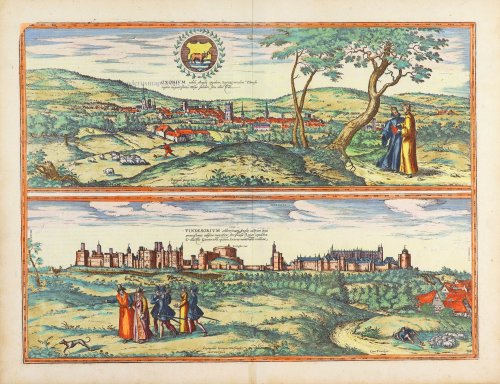
OXFORD
TRANSLATION OF CAPTION: Oxford, well-known town in England. Embellishes the northern bank of the Thames by its attractive, healthy location.
COMMENTARY BY BRAUN: "Oxford, known long ago as Bellositum due to its charming position, is a city on the northern bank of the River Thames [...] It is generally known that it has a salubrious and pleasant situation and also that the surrounding countryside provides everything in abundance. Oxford has a prestigious school, as all who have attended other schools in Europe will know."
The view shows Oxford from the north, ensconced in a broad landscape of gently rolling hills. Oxford is first mentioned in the so-called Anglo-Saxon Chronicle in the year AD 912 and goes back to the founding of a convent by the Saxon nun Frideswide in the 8th century. Today St Frideswide is the patron saint of the city and the university. The University of Oxford is the oldest and, together with Cambridge, the most famous university in England. It developed out of several different schools, mostly monastic, whose existence is documented as far back as the early 12th century. The city's oldest college is University College, founded in 1249.
WINDSOR CASTLE
CAPTION: Windsor, the famous English castle. Remarkable for its pleasant surroundings, magnificent buildings, ornate royal tombs and the famous Order of the Garter.
COMMENTARY BY BRAUN: "Windsor is a royal castle in England, which, so it is believed, was first built in the time of King Arthur and extended by King Edward III, who added many new buildings. It is situated on a charming hill, eight miles from the capital of London. It is 410 paces from the Thames, which changes its course here from south to north. The castle is surrounded by an unbelievably charming and broad plain [...]. There huntsmen and the nobility go hunting with falcons."
The engraving shows a view of Windsor Castle seen from the north. In the foreground is a group of nobles, and just below the castle walls there is a hunting scene. Windsor Castle was built under William the Conqueror around 1070. The original wooden construction was placed on a man-made hill. The Round Tower was built on the same site one hundred years later, under Henry II. In 1350 King Edward III began reconstructing the castle, which lasted a total of 24 years. On the left are the royal apartments, and on the right St George's Chapel, built in the Gothic Perpendicular style. The annual meeting of the Order of the Garter, founded by Edward III in 1348, is celebrated in this chapel. Today Windsor Castle is one of the official residences of the British monarchy. (Taschen)
Braun G. & Hogenberg F. and the Civitates Orbis Terrarum.
The Civitates Orbis Terrarum, also known as the 'Braun & Hogenberg', is a six-volume town atlas and the most excellent book of town views and plans ever published: 363 engravings, sometimes beautifully coloured. It was one of the best-selling works in the last quarter of the 16th century. Georg Braun, a skilled writer, wrote the text accompanying the plans and views on the verso. Many plates were engraved after the original drawings of a professional artist, Joris Hoefnagel (1542-1600). The first volume was published in Latin in 1572 and the sixth in 1617. Frans Hogenberg, a talented engraver, created the tables for volumes I through IV, and Simon van den Neuwel made those for volumes V and VI. Other contributors were cartographers Daniel Freese and Heinrich Rantzau, who provided valuable geographical information. Works by Jacob van Deventer, Sebastian Münster, and Johannes Stumpf were also used as references. Translations appeared in German and French, making the atlas accessible to a broader audience.
Since its original publication of volume 1 in 1572, the Civitates Orbis Terrarum has left an indelible mark on the history of cartography. Seven more editions followed the first volume in 1575, 1577, 1582, 1588, 1593, 1599, and 1612. Vol.2, initially released in 1575, saw subsequent editions in 1597 and 1612. The subsequent volumes, each a treasure trove of historical insights, graced the world in 1581, 1588, 1593, 1599, and 1606. The German translation of the first volume, a testament to its widespread appeal, debuted in 1574, followed by the French edition in 1575.
Several printers were involved: Theodor Graminaeus, Heinrich von Aich, Gottfried von Kempen, Johannis Sinniger, Bertram Buchholtz, and Peter von Brachel, all of whom worked in Cologne.
Georg Braun (1541-1622)
Georg Braun, the author of the text accompanying the plans and views in the Civitates Orbis Terrarum, was born in Cologne in 1541. After his studies in Cologne, he entered the Jesuit Order as a novice, indicating his commitment to learning and intellectual pursuits. In 1561, he obtained his bachelor's degree; in 1562, he received his Magister Artium, further demonstrating his academic achievements. Although he left the Jesuit Order, he continued his studies in theology, gaining a licentiate in theology. His theological background likely influenced the content and tone of the text in the Civitates Orbis Terrarum, adding a unique perspective to the work.
Frans Hogenberg (1535-1590)
Frans Hogenberg was a Flemish and German painter, engraver, and mapmaker. He was born in Mechelen as the son of Nicolaas Hogenberg.
By the end of the 1560s, Frans Hogenberg was employed upon Abraham Ortelius's Theatrum Orbis Terrarum, published in 1570; he is named an engraver of numerous maps. In 1568, he was banned from Antwerp by the Duke of Alva and travelled to London, where he stayed a few years before emigrating to Cologne. He immediately embarked on his two most important works, the Civitates, published in 1572 and the Geschichtsblätter, which appeared in several series from 1569 until about 1587.
Thanks to large-scale projects like the Geschichtsblätter and the Civitates, Hogenberg's social circumstances improved with each passing year. He died as a wealthy man in Cologne in 1590.
Oxonium Nobile Anglie Oppidum [on sheet with] Vindesorium Celeberrimum Angliae Castrum ...
Item Number: 29346 Authenticity Guarantee
Category: Antique maps > Europe > British Isles - Cities
Old antique map with two views of Oxford and Windsor Castel, by Braun and Hogenberg, after G. Hoefnagel.
Title: Oxonium Nobile Anglie Oppidum [on sheet with] Vindesorium Celeberrimum Angliae Castrum ...
Depingebat Georgius Hoefnagle.
Cum Privilegio.
Designer: Georg Hoefnagel.
Date of the first edition: 1575.
Date of this map: 1623.
Copper engraving, printed on paper.
Size (not including margins): 360 x 480mm (14.17 x 18.9 inches).
Verso: Latin text.
Condition: Original coloured, excellent.
Condition Rating: A.
From: Civitates Orbis Terrarum, ... Part 2: De Praecipuis, Totius Universi Urbibus, Liber Secundus. Köln, Petrus von Brachel, 1623. (Van der Krogt 4, 41:1.2)
OXFORD
TRANSLATION OF CAPTION: Oxford, well-known town in England. Embellishes the northern bank of the Thames by its attractive, healthy location.
COMMENTARY BY BRAUN: "Oxford, known long ago as Bellositum due to its charming position, is a city on the northern bank of the River Thames [...] It is generally known that it has a salubrious and pleasant situation and also that the surrounding countryside provides everything in abundance. Oxford has a prestigious school, as all who have attended other schools in Europe will know."
The view shows Oxford from the north, ensconced in a broad landscape of gently rolling hills. Oxford is first mentioned in the so-called Anglo-Saxon Chronicle in the year AD 912 and goes back to the founding of a convent by the Saxon nun Frideswide in the 8th century. Today St Frideswide is the patron saint of the city and the university. The University of Oxford is the oldest and, together with Cambridge, the most famous university in England. It developed out of several different schools, mostly monastic, whose existence is documented as far back as the early 12th century. The city's oldest college is University College, founded in 1249.
WINDSOR CASTLE
CAPTION: Windsor, the famous English castle. Remarkable for its pleasant surroundings, magnificent buildings, ornate royal tombs and the famous Order of the Garter.
COMMENTARY BY BRAUN: "Windsor is a royal castle in England, which, so it is believed, was first built in the time of King Arthur and extended by King Edward III, who added many new buildings. It is situated on a charming hill, eight miles from the capital of London. It is 410 paces from the Thames, which changes its course here from south to north. The castle is surrounded by an unbelievably charming and broad plain [...]. There huntsmen and the nobility go hunting with falcons."
The engraving shows a view of Windsor Castle seen from the north. In the foreground is a group of nobles, and just below the castle walls there is a hunting scene. Windsor Castle was built under William the Conqueror around 1070. The original wooden construction was placed on a man-made hill. The Round Tower was built on the same site one hundred years later, under Henry II. In 1350 King Edward III began reconstructing the castle, which lasted a total of 24 years. On the left are the royal apartments, and on the right St George's Chapel, built in the Gothic Perpendicular style. The annual meeting of the Order of the Garter, founded by Edward III in 1348, is celebrated in this chapel. Today Windsor Castle is one of the official residences of the British monarchy. (Taschen)
Braun G. & Hogenberg F. and the Civitates Orbis Terrarum.
The Civitates Orbis Terrarum, also known as the 'Braun & Hogenberg', is a six-volume town atlas and the most excellent book of town views and plans ever published: 363 engravings, sometimes beautifully coloured. It was one of the best-selling works in the last quarter of the 16th century. Georg Braun, a skilled writer, wrote the text accompanying the plans and views on the verso. Many plates were engraved after the original drawings of a professional artist, Joris Hoefnagel (1542-1600). The first volume was published in Latin in 1572 and the sixth in 1617. Frans Hogenberg, a talented engraver, created the tables for volumes I through IV, and Simon van den Neuwel made those for volumes V and VI. Other contributors were cartographers Daniel Freese and Heinrich Rantzau, who provided valuable geographical information. Works by Jacob van Deventer, Sebastian Münster, and Johannes Stumpf were also used as references. Translations appeared in German and French, making the atlas accessible to a broader audience.
Since its original publication of volume 1 in 1572, the Civitates Orbis Terrarum has left an indelible mark on the history of cartography. Seven more editions followed the first volume in 1575, 1577, 1582, 1588, 1593, 1599, and 1612. Vol.2, initially released in 1575, saw subsequent editions in 1597 and 1612. The subsequent volumes, each a treasure trove of historical insights, graced the world in 1581, 1588, 1593, 1599, and 1606. The German translation of the first volume, a testament to its widespread appeal, debuted in 1574, followed by the French edition in 1575.
Several printers were involved: Theodor Graminaeus, Heinrich von Aich, Gottfried von Kempen, Johannis Sinniger, Bertram Buchholtz, and Peter von Brachel, all of whom worked in Cologne.
Georg Braun (1541-1622)
Georg Braun, the author of the text accompanying the plans and views in the Civitates Orbis Terrarum, was born in Cologne in 1541. After his studies in Cologne, he entered the Jesuit Order as a novice, indicating his commitment to learning and intellectual pursuits. In 1561, he obtained his bachelor's degree; in 1562, he received his Magister Artium, further demonstrating his academic achievements. Although he left the Jesuit Order, he continued his studies in theology, gaining a licentiate in theology. His theological background likely influenced the content and tone of the text in the Civitates Orbis Terrarum, adding a unique perspective to the work.
Frans Hogenberg (1535-1590)
Frans Hogenberg was a Flemish and German painter, engraver, and mapmaker. He was born in Mechelen as the son of Nicolaas Hogenberg.
By the end of the 1560s, Frans Hogenberg was employed upon Abraham Ortelius's Theatrum Orbis Terrarum, published in 1570; he is named an engraver of numerous maps. In 1568, he was banned from Antwerp by the Duke of Alva and travelled to London, where he stayed a few years before emigrating to Cologne. He immediately embarked on his two most important works, the Civitates, published in 1572 and the Geschichtsblätter, which appeared in several series from 1569 until about 1587.
Thanks to large-scale projects like the Geschichtsblätter and the Civitates, Hogenberg's social circumstances improved with each passing year. He died as a wealthy man in Cologne in 1590.
Related items

Brightstowe, Vulgo; Quondam Venta, Florentissimum. 1616
Bristol, by Braun Georg & Hogenberg Frans
[Item number: 26909]

Oxonium Comitatus, vulgo Oxford Shire. 1645
Oxfordshire by J. Blaeu
[Item number: 29773]

Omnium Sanct.rum-Basilica in Universitate urbis Oxfordiae - L'Eglise de tous le Saints dans l'Université d'Oxford. c. 1750
Optical View of Oxford - All Saints Church, by Martin Engelbrecht.
[Item number: 31906]

Vuë du Colege de Ste-Marie et de l'Hotel de Ville d'Oxford. c. 1750
Optical View of Oxford, by Martin Engelbrecht.
[Item number: 31908]