Esztergom, by Georg Braun & Frans Hogenberg. 1596
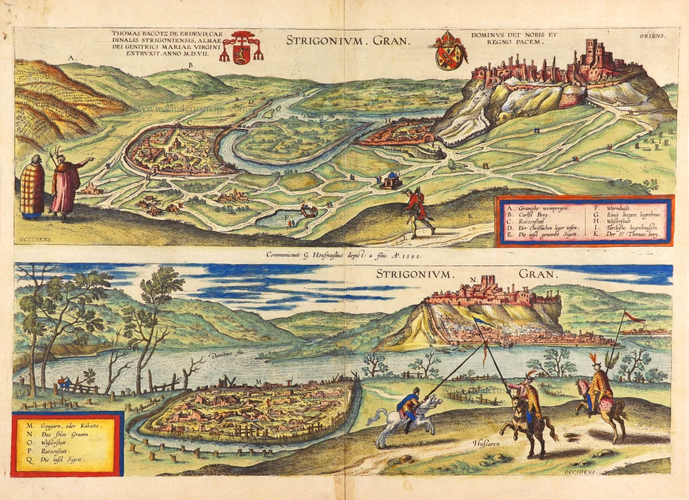

COMMENTARY BY BRAUN: "Esztergom, also called Gran, is a town in Lower Hungary on the right bank of the Danube [...]. It is the seat of an archbishop, all the more praiseworthy because the archbishop of Gran crowns the kings of Hungary in a special ceremony. [...] The kings used to hold court here because of its secure fortifications and protected apartments. Above the town, on the hill's summit, lies a castle. [...] The town is particularly embellished by its cathedral, dedicated to St Adalbert the Martyr."
The town of Esztergom, ravaged by the Turks in 1542, is presented from two viewpoints. The top illustration is seen from the east and shows the castle ruins overlooking the town at the Hron and Danube's confluence. The bottom image shows the destroyed Lower Town and the castle from the west. In the left-hand foreground, on the left bank of the Danube, lies the similarly razed village of Parkany (M). In the Middle Ages, Esztergom was one of the most important royal palaces and the seat of the archbishops of Esztergom. In the 12th century, King Béla III of Hungary made Esztergom his sole residence and confirmed the town as the centre of political and cultural life in Hungary during this era. With the relocation of the royal home to Visegrad, Esztergom and the palace passed into the archbishop's possession; indeed, the Primate of Hungary continues to reside in the town even today. In the 16th century, Esztergom was reduced to a small provincial city following its conquest by the Turks, whose hands remained until 1683. Not until the 18th century and the archbishops' return from their exile in Trnava did the town flourish anew. (Taschen).
Braun G. & Hogenberg F. and the Civitates Orbis Terrarum.
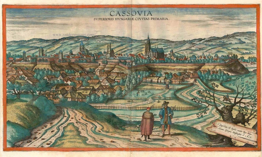
The Civitates Orbis Terrarum, also known as the 'Braun & Hogenberg', is a six-volume town atlas and the most excellent book of town views and plans ever published: 363 engravings, sometimes beautifully coloured. It was one of the best-selling works in the last quarter of the 16th century. Georg Braun, a skilled writer, wrote the text accompanying the plans and views on the verso. Many plates were engraved after the original drawings of a professional artist, Joris Hoefnagel (1542-1600). The first volume was published in Latin in 1572 and the sixth in 1617. Frans Hogenberg, a talented engraver, created the tables for volumes I through IV, and Simon van den Neuwel made those for volumes V and VI. Other contributors were cartographers Daniel Freese and Heinrich Rantzau, who provided valuable geographical information. Works by Jacob van Deventer, Sebastian Münster, and Johannes Stumpf were also used as references. Translations appeared in German and French, making the atlas accessible to a wider audience.
Since its original publication of volume 1 in 1572, the Civitates Orbis Terrarum has left an indelible mark on the history of cartography. The first volume was followed by seven more editions in 1575, 1577, 1582, 1588, 1593, 1599, and 1612. Vol.2, initially released in 1575, saw subsequent editions in 1597 and 1612. The subsequent volumes, each a treasure trove of historical insights, graced the world in 1581, 1588, 1593, 1599, and 1606. The German translation of the first volume, a testament to its widespread appeal, debuted in 1574, followed by the French edition in 1575.
Several printers were involved: Theodor Graminaeus, Heinrich von Aich, Gottfried von Kempen, Johannis Sinniger, Bertram Buchholtz, and Peter von Brachel, all of whom worked in Cologne.
Georg Braun (1541-1622)
Georg Braun, the author of the text accompanying the plans and views in the Civitates Orbis Terrarum, was born in Cologne in 1541. After his studies in Cologne, he entered the Jesuit Order as a novice, indicating his commitment to learning and intellectual pursuits. In 1561, he obtained his bachelor's degree; in 1562, he received his Magister Artium, further demonstrating his academic achievements. Although he left the Jesuit Order, he continued his studies in theology, gaining a licentiate in theology. His theological background likely influenced the content and tone of the text in the Civitates Orbis Terrarum, adding a unique perspective to the work.
Frans Hogenberg (1535-1590)
Frans Hogenberg was a Flemish and German painter, engraver, and mapmaker. He was born in Mechelen as the son of Nicolaas Hogenberg.
By the end of the 1560s, Frans Hogenberg was employed upon Abraham Ortelius's Theatrum Orbis Terrarum, published in 1570; he is named an engraver of numerous maps. In 1568, he was banned from Antwerp by the Duke of Alva and travelled to London, where he stayed a few years before emigrating to Cologne. He immediately embarked on his two most important works, the Civitates, published in 1572 and the Geschichtsblätter, which appeared in several series from 1569 until about 1587.
Thanks to large-scale projects like the Geschichtsblätter and the Civitates, Hogenberg's social circumstances improved with each passing year. He died as a wealthy man in Cologne in 1590.
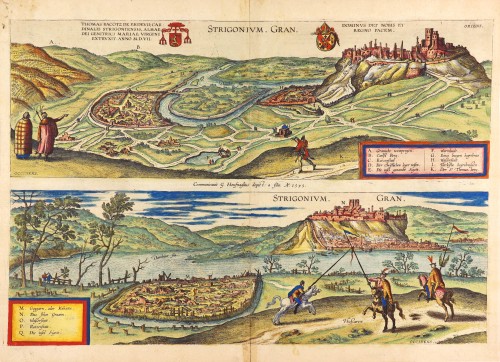
Strigonium. Gran.
Item Number: 28957 Authenticity Guarantee
Category: Antique maps > Europe > Central Europe
Two antique bird’s-eye views of Esztergom, by Georg Braun & Frans Hogenberg.
Title: Strigonium. Gran.
Communicavit G. Houfnaglius depict: a filio. A° 1595.
Designer: Georg Hoefnagel.
Date of the first edition: 1596.
Date of this map: 1596.
Date on map: 1595.
Copper engraving, printed on paper.
Map size: 350 x 515mm (13.78 x 20.28 inches).
Sheet size: 395 x 530mm (15.55 x 20.87 inches).
Verso: Latin text.
Condition: Original coloured, excellent.
Condition Rating: A+.
From: Urbium Praecipuarum Mundi Theatrum Quintum Auctore Georgio Braunio Agrippinate. Part 5. Köln, 1596/97. (Van der Krogt 4, 41:1.5)
COMMENTARY BY BRAUN: "Esztergom, also called Gran, is a town in Lower Hungary on the right bank of the Danube [...]. It is the seat of an archbishop, all the more praiseworthy because the archbishop of Gran crowns the kings of Hungary in a special ceremony. [...] The kings used to hold court here because of its secure fortifications and protected apartments. Above the town, on the hill's summit, lies a castle. [...] The town is particularly embellished by its cathedral, dedicated to St Adalbert the Martyr."
The town of Esztergom, ravaged by the Turks in 1542, is presented from two viewpoints. The top illustration is seen from the east and shows the castle ruins overlooking the town at the Hron and Danube's confluence. The bottom image shows the destroyed Lower Town and the castle from the west. In the left-hand foreground, on the left bank of the Danube, lies the similarly razed village of Parkany (M). In the Middle Ages, Esztergom was one of the most important royal palaces and the seat of the archbishops of Esztergom. In the 12th century, King Béla III of Hungary made Esztergom his sole residence and confirmed the town as the centre of political and cultural life in Hungary during this era. With the relocation of the royal home to Visegrad, Esztergom and the palace passed into the archbishop's possession; indeed, the Primate of Hungary continues to reside in the town even today. In the 16th century, Esztergom was reduced to a small provincial city following its conquest by the Turks, whose hands remained until 1683. Not until the 18th century and the archbishops' return from their exile in Trnava did the town flourish anew. (Taschen).
Braun G. & Hogenberg F. and the Civitates Orbis Terrarum.
The Civitates Orbis Terrarum, also known as the 'Braun & Hogenberg', is a six-volume town atlas and the most excellent book of town views and plans ever published: 363 engravings, sometimes beautifully coloured. It was one of the best-selling works in the last quarter of the 16th century. Georg Braun, a skilled writer, wrote the text accompanying the plans and views on the verso. Many plates were engraved after the original drawings of a professional artist, Joris Hoefnagel (1542-1600). The first volume was published in Latin in 1572 and the sixth in 1617. Frans Hogenberg, a talented engraver, created the tables for volumes I through IV, and Simon van den Neuwel made those for volumes V and VI. Other contributors were cartographers Daniel Freese and Heinrich Rantzau, who provided valuable geographical information. Works by Jacob van Deventer, Sebastian Münster, and Johannes Stumpf were also used as references. Translations appeared in German and French, making the atlas accessible to a wider audience.
Since its original publication of volume 1 in 1572, the Civitates Orbis Terrarum has left an indelible mark on the history of cartography. The first volume was followed by seven more editions in 1575, 1577, 1582, 1588, 1593, 1599, and 1612. Vol.2, initially released in 1575, saw subsequent editions in 1597 and 1612. The subsequent volumes, each a treasure trove of historical insights, graced the world in 1581, 1588, 1593, 1599, and 1606. The German translation of the first volume, a testament to its widespread appeal, debuted in 1574, followed by the French edition in 1575.
Several printers were involved: Theodor Graminaeus, Heinrich von Aich, Gottfried von Kempen, Johannis Sinniger, Bertram Buchholtz, and Peter von Brachel, all of whom worked in Cologne.
Georg Braun (1541-1622)
Georg Braun, the author of the text accompanying the plans and views in the Civitates Orbis Terrarum, was born in Cologne in 1541. After his studies in Cologne, he entered the Jesuit Order as a novice, indicating his commitment to learning and intellectual pursuits. In 1561, he obtained his bachelor's degree; in 1562, he received his Magister Artium, further demonstrating his academic achievements. Although he left the Jesuit Order, he continued his studies in theology, gaining a licentiate in theology. His theological background likely influenced the content and tone of the text in the Civitates Orbis Terrarum, adding a unique perspective to the work.
Frans Hogenberg (1535-1590)
Frans Hogenberg was a Flemish and German painter, engraver, and mapmaker. He was born in Mechelen as the son of Nicolaas Hogenberg.
By the end of the 1560s, Frans Hogenberg was employed upon Abraham Ortelius's Theatrum Orbis Terrarum, published in 1570; he is named an engraver of numerous maps. In 1568, he was banned from Antwerp by the Duke of Alva and travelled to London, where he stayed a few years before emigrating to Cologne. He immediately embarked on his two most important works, the Civitates, published in 1572 and the Geschichtsblätter, which appeared in several series from 1569 until about 1587.
Thanks to large-scale projects like the Geschichtsblätter and the Civitates, Hogenberg's social circumstances improved with each passing year. He died as a wealthy man in Cologne in 1590.