Budapest by Georg Braun & Frans Hogenberg c. 1625


Braun G. & Hogenberg F. and the Civitates Orbis Terrarum.
The Civitates Orbis Terrarum, or the "Braun & Hogenberg", is a six-volume town atlas and the most excellent book of town views and plans ever published: 363 engravings, sometimes beautifully coloured. It was one of the best-selling works in the last quarter of the 16th century. Georg Braun wrote the text accompanying the plans and views on the verso. Many plates were engraved after the original drawings of a professional artist, a professional artist, Joris Hoefnagel (1542-1600). The first volume was published in Latin in 1572, and the sixth in 1617. Frans Hogenberg created the tables for volumes I through IV, and Simon van den Neuwel made those for volumes V and VI. Other contributors were cartographers Daniel Freese and Heinrich Rantzau. Works by Jacob van Deventer, Sebastian Münster, and Johannes Stumpf were also used. Translations appeared in German and French.
Following the original publication of Volume 1 of the Civitates in 1572, seven further editions of 1575, 1577, 1582, 1588, 1593, 1599 and 1612 can be identified. Vol.2, first issued in 1575, was followed by further editions in 1597 and 1612. The subsequent volumes appeared in 1581, 1588, 1593, 1599 and 1606. The German translation of the first volume appeared from 1574 on, and the French edition from 1575 on.
Several printers were involved: Theodor Graminaeus, Heinrich von Aich, Gottfried von Kempen, Johannis Sinniger, Bertram Buchholtz and Peter von Brachel, who all worked in Cologne.
Georg Braun (1541-1622)
Georg Braun was born in Cologne in 1541. After his studies in Cologne, he entered the Jesuit Order as a novice. 1561, he obtained his bachelor's degree, and in 1562, he received his Magister Artium. Although he left the Jesuit Order, he studied theology, gaining a licentiate in theology.
Frans Hogenberg (1535-1590)
Frans Hogenberg was a Flemish and German painter, engraver, and mapmaker. He was born in Mechelen as the son of Nicolaas Hogenberg.
By the end of the 1560s, Frans Hogenberg was employed upon Abraham Ortelius's Theatrum Orbis Terrarum, published in 1570; he is named an engraver of numerous maps. In 1568, he was banned from Antwerp by the Duke of Alva and travelled to London, where he stayed a few years before emigrating to Cologne. He immediately embarked on his two most important works, the Civitates, published in 1572 and the Geschichtsblätter, which appeared in several series from 1569 until about 1587.
Thanks to large-scale projects like the Geschichtsblätter and the Civitates, Hogenberg's social circumstances improved with each passing year. He died as a wealthy man in Cologne in 1590.
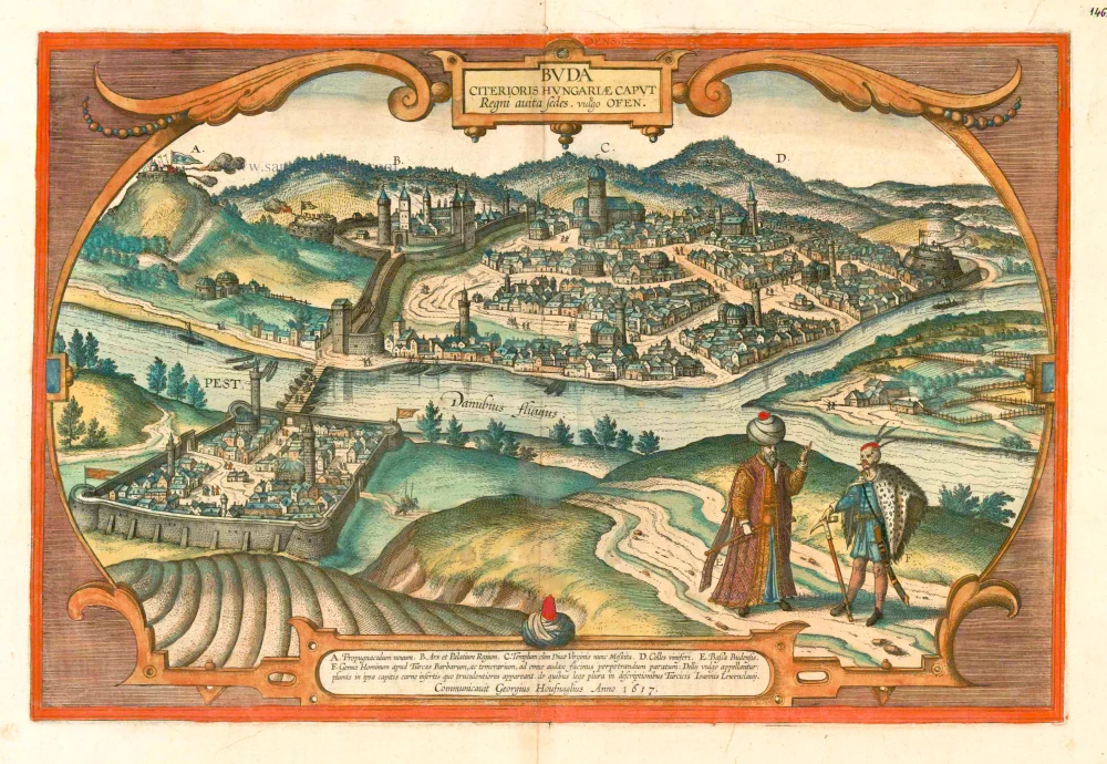
Buda Citerioris Hungariae Caput Regni avita sedes. vulgo Ofen
Item Number: 16444 Authenticity Guarantee
Category: Antique maps > Europe > Central Europe
Antique map - Bird's-eye view of Budapest by Braun and Hogenberg after G. Hoefnagel, 1617. Key to six locations.
TRANSLATION OF CARTOUCHE TEXT TOP: Buda, capital of Hungary and ancestral seat of the king, called Ofen in German.
CARTOUCHE BOTTOM: A. New outwork - B. Fortress and royal palace - C. Former church of the Holy Virgin, today a mosque - D. Vineyards - E. The Bassa of Buda - F. A barbaric tribe among the Turks, fearless and ready to commit any atrocity; they are commonly known as the Deli. They stick feathers through the skin on their heads, which makes them appear even more bloodthirsty. More can be read about them in the descriptions of the Turks by Johannes Lewenclavius.
COMMENTARY BY BRAUN: "The main church there was erected by Kings Géza and Ladislas in honour of the Mother of God [...]. Opposite the palace is a high hill on which the Turks today have a strong fortress and garrison. Formerly it was called St Gellert's Hill because a church was dedicated to him there, where pilgrims came in times of plague. [...] But at present nothing is to be found there except Mohammedan abominations. Opposite Buda, on the other side of the Danube, is Pest - also a free city, but somewhat smaller than Buda - in a flat, very fertile area with fine garden and meadows, such as are found in no other place. And it is a great pity that these two fine cities together with all the surrounding area have fallen into the hands of the Turkish archenemy."
This is a view from the east from a virtual elevated view point of the two cities of Pest and, on the opposite bank of the Danube, Buda, with the castle Hill and the palace. They are clearly in the hands of the Turks - Pest since 1526, Buda since 1541. This is indicated by the many mosques depicted in both cities. Towering above them all is the church of St Matthew (really the church of Our Lady, C), which is shown to have been converted into a mosque by the crescent on the tower and the dome. In the foreground, in turban and kaftan, is the Ottoman governor, the Pasha of Buda (E). Beside him, with a feather headdress, is a member of the Deli (F) - an Ottoman elite troop that was notorious for its cold-blooded slaughter, usually under the influence of drugs ( deli is Turkish for "lunatic", "reckless"). In 1686 Pest and Buda were reconquered by the Christians, in 1873 the two cities were united to form Budapest. (Taschen)
Date of the first edition: 1617
Date of this map: c. 1625
Copper engraving, printed on paper.
Size (not including margins): 32 x 48.5cm (12.5 x 18.9 inches)
Verso text: French
Condition: Contemporary old coloured., excellent.
Condition Rating: A
References: Van der Krogt 4, 689; Fauser, #2101; Taschen, Br. Hog., p.470.
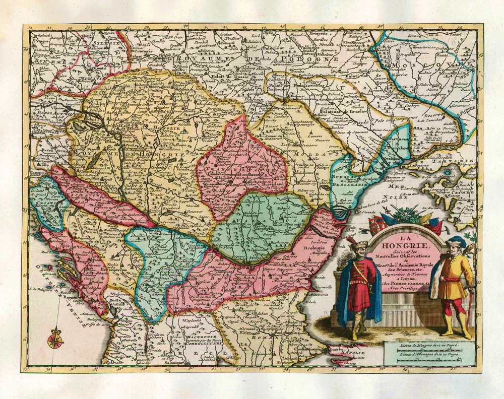
From: Théatre des Principales Villes de tout l'Univers Vol. VI. c. 1625. (Van der Krogt 4, 41:3.6)
Braun G. & Hogenberg F. and the Civitates Orbis Terrarum.
The Civitates Orbis Terrarum, or the "Braun & Hogenberg", is a six-volume town atlas and the most excellent book of town views and plans ever published: 363 engravings, sometimes beautifully coloured. It was one of the best-selling works in the last quarter of the 16th century. Georg Braun wrote the text accompanying the plans and views on the verso. Many plates were engraved after the original drawings of a professional artist, a professional artist, Joris Hoefnagel (1542-1600). The first volume was published in Latin in 1572, and the sixth in 1617. Frans Hogenberg created the tables for volumes I through IV, and Simon van den Neuwel made those for volumes V and VI. Other contributors were cartographers Daniel Freese and Heinrich Rantzau. Works by Jacob van Deventer, Sebastian Münster, and Johannes Stumpf were also used. Translations appeared in German and French.
Following the original publication of Volume 1 of the Civitates in 1572, seven further editions of 1575, 1577, 1582, 1588, 1593, 1599 and 1612 can be identified. Vol.2, first issued in 1575, was followed by further editions in 1597 and 1612. The subsequent volumes appeared in 1581, 1588, 1593, 1599 and 1606. The German translation of the first volume appeared from 1574 on, and the French edition from 1575 on.
Several printers were involved: Theodor Graminaeus, Heinrich von Aich, Gottfried von Kempen, Johannis Sinniger, Bertram Buchholtz and Peter von Brachel, who all worked in Cologne.
Georg Braun (1541-1622)
Georg Braun was born in Cologne in 1541. After his studies in Cologne, he entered the Jesuit Order as a novice. 1561, he obtained his bachelor's degree, and in 1562, he received his Magister Artium. Although he left the Jesuit Order, he studied theology, gaining a licentiate in theology.
Frans Hogenberg (1535-1590)
Frans Hogenberg was a Flemish and German painter, engraver, and mapmaker. He was born in Mechelen as the son of Nicolaas Hogenberg.
By the end of the 1560s, Frans Hogenberg was employed upon Abraham Ortelius's Theatrum Orbis Terrarum, published in 1570; he is named an engraver of numerous maps. In 1568, he was banned from Antwerp by the Duke of Alva and travelled to London, where he stayed a few years before emigrating to Cologne. He immediately embarked on his two most important works, the Civitates, published in 1572 and the Geschichtsblätter, which appeared in several series from 1569 until about 1587.
Thanks to large-scale projects like the Geschichtsblätter and the Civitates, Hogenberg's social circumstances improved with each passing year. He died as a wealthy man in Cologne in 1590.