
Breslau, by Homann Heirs. c. 1757
The Homann Family: Masters of German Cartography and Publishing
The Homann family stands as one of the most significant names in the history of German cartography and publishing. Their maps, atlases, and geographic works not only shaped contemporary understanding of the world during the 18th century but also left an enduring legacy in the fields of geography, engraving, and scholarly publishing.
The family's prominence began with Johann Baptist Homann (1664–1724), a native of Oberkammlach in Bavaria. Initially trained in law and theology, Johann Baptist later turned to engraving and cartography — a field that was flourishing amid the Age of Discovery and the growing demand for precise geographic knowledge.
In 1702, he founded his own publishing house in Nürnberg, a city then renowned for its vibrant intellectual, artistic, and scientific community. Nuremberg’s rich tradition of printmaking and map production provided fertile ground for Homann's enterprise.
Johann Baptist Homann quickly rose to prominence as one of Germany’s leading cartographers and publishers. His works combined technical accuracy, artistic merit, and rich ornamentation, often embellished with elaborate cartouches, mythological scenes, and heraldic symbols.
In 1715, Homann was appointed Imperial Geographer to the Holy Roman Emperor Charles VI. This prestigious title solidified his status and bestowed upon his publishing house both credibility and influence. His most famous works include:
- Atlas Novus Terrarum Orbis (1707) — an early and ambitious atlas project.
- Grosser Atlas über die ganze Welt (1716) — one of the most crucial German world atlases of the early 18th century.
Homann’s maps covered both European and global territories, including the Americas, Asia, and Africa, reflecting contemporary geographical knowledge and political boundaries.
The Homann Heirs (Homannische Erben)
After Johann Baptist Homann died in 1724, his son Johann Christoph Homann (1703–1730) briefly took over the business. However, Johann Christoph died at a young age, and the enterprise was then continued under the name Homännische Erben ("Homann Heirs"), a partnership of family members and associates.
Despite the loss of its founder, the firm remained highly productive and influential for several decades. The Homann Heirs continued to publish atlases, wall maps, city views, and geographical treatises well into the late 18th century. Their catalogue included works by noted cartographers such as Johann Matthias Hase, Leonhard Euler, and Tobias Conrad Lotter.
The Homann publishing house played a crucial role in disseminating geographic and scientific knowledge during the Enlightenment. Their maps combined artistry with empirical detail and were sought after by scholars, navigators, governments, and collectors.
Several of their works are now prized as valuable historical artefacts, housed in museums, libraries, and private collections around the world. The Homann Heirs' firm gradually declined by the end of the 18th century, overtaken by newer publishing houses and changing technologies, but their contribution to the cartographic tradition remains significant.
The Homann family’s name is indelibly linked to the golden age of German cartography. Through meticulous craftsmanship and a keen sense of visual storytelling, they charted the known world of their time, leaving a remarkable record of early modern geography. Today, their maps not only inform historians of cartography but also captivate collectors and enthusiasts for their aesthetic beauty and historical value.
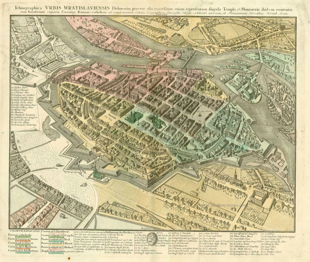
Ichnographica Urbis Wratislaviensis Delineatio ...
Item Number: 21289 Authenticity Guarantee
Category: Antique maps > Europe > Eastern Europe
Antique map of Breslau by Homann Heirs.
Title: Ichnographica Urbis Wratislaviensis Delineatio ...
Date: c. 1757.
Copper engraving, printed on paper.
Size (not including margins): 410 x 550mm (16.14 x 21.65 inches).
Verso: Blank.
Condition: Old coloured, linen-backed, excellent.
Condition Rating: A.
From: Grosser Atlas. Nürnberg, c. 1757.
The Homann Family: Masters of German Cartography and Publishing
The Homann family stands as one of the most significant names in the history of German cartography and publishing. Their maps, atlases, and geographic works not only shaped contemporary understanding of the world during the 18th century but also left an enduring legacy in the fields of geography, engraving, and scholarly publishing.
The family's prominence began with Johann Baptist Homann (1664–1724), a native of Oberkammlach in Bavaria. Initially trained in law and theology, Johann Baptist later turned to engraving and cartography — a field that was flourishing amid the Age of Discovery and the growing demand for precise geographic knowledge.
In 1702, he founded his own publishing house in Nürnberg, a city then renowned for its vibrant intellectual, artistic, and scientific community. Nuremberg’s rich tradition of printmaking and map production provided fertile ground for Homann's enterprise.
Johann Baptist Homann quickly rose to prominence as one of Germany’s leading cartographers and publishers. His works combined technical accuracy, artistic merit, and rich ornamentation, often embellished with elaborate cartouches, mythological scenes, and heraldic symbols.
In 1715, Homann was appointed Imperial Geographer to the Holy Roman Emperor Charles VI. This prestigious title solidified his status and bestowed upon his publishing house both credibility and influence. His most famous works include:
- Atlas Novus Terrarum Orbis (1707) — an early and ambitious atlas project.
- Grosser Atlas über die ganze Welt (1716) — one of the most crucial German world atlases of the early 18th century.
Homann’s maps covered both European and global territories, including the Americas, Asia, and Africa, reflecting contemporary geographical knowledge and political boundaries.
The Homann Heirs (Homannische Erben)
After Johann Baptist Homann died in 1724, his son Johann Christoph Homann (1703–1730) briefly took over the business. However, Johann Christoph died at a young age, and the enterprise was then continued under the name Homännische Erben ("Homann Heirs"), a partnership of family members and associates.
Despite the loss of its founder, the firm remained highly productive and influential for several decades. The Homann Heirs continued to publish atlases, wall maps, city views, and geographical treatises well into the late 18th century. Their catalogue included works by noted cartographers such as Johann Matthias Hase, Leonhard Euler, and Tobias Conrad Lotter.
The Homann publishing house played a crucial role in disseminating geographic and scientific knowledge during the Enlightenment. Their maps combined artistry with empirical detail and were sought after by scholars, navigators, governments, and collectors.
Several of their works are now prized as valuable historical artefacts, housed in museums, libraries, and private collections around the world. The Homann Heirs' firm gradually declined by the end of the 18th century, overtaken by newer publishing houses and changing technologies, but their contribution to the cartographic tradition remains significant.
The Homann family’s name is indelibly linked to the golden age of German cartography. Through meticulous craftsmanship and a keen sense of visual storytelling, they charted the known world of their time, leaving a remarkable record of early modern geography. Today, their maps not only inform historians of cartography but also captivate collectors and enthusiasts for their aesthetic beauty and historical value.
Related items
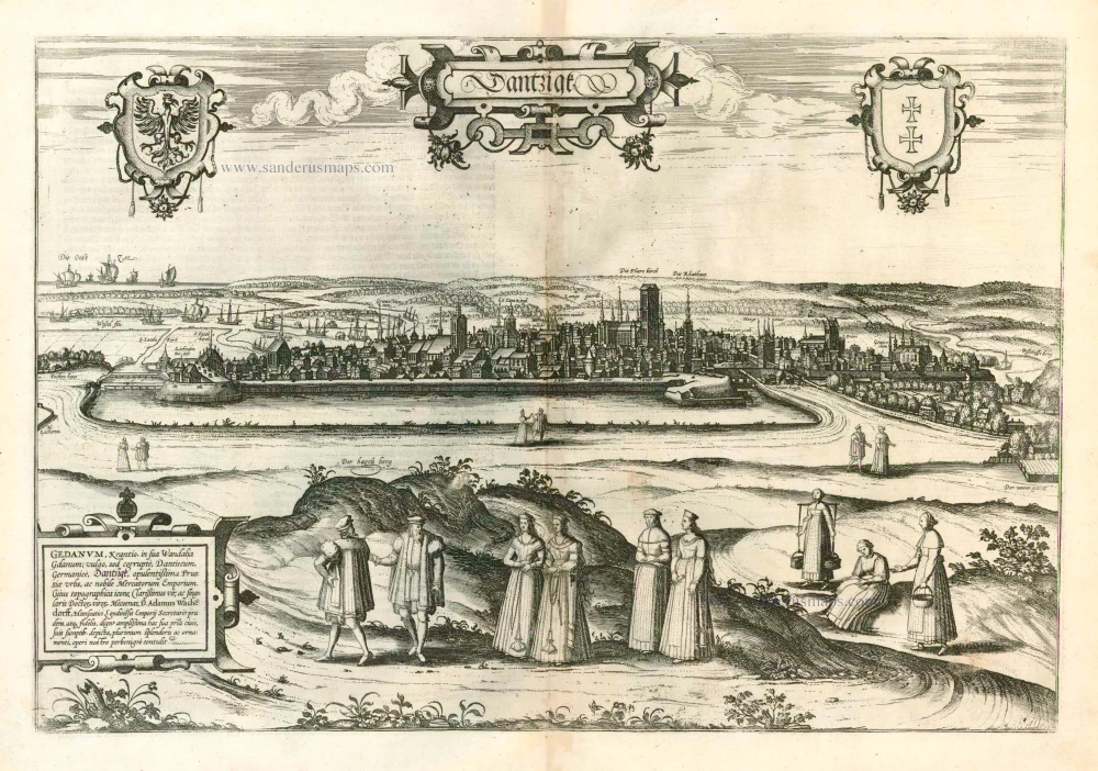
Dantzigk - Gedanum, Krantio, in sua Wandalia Gdanum; . . . 1576
Gdansk, by Georg Braun and Frans Hogenberg.
[Item number: 4056]
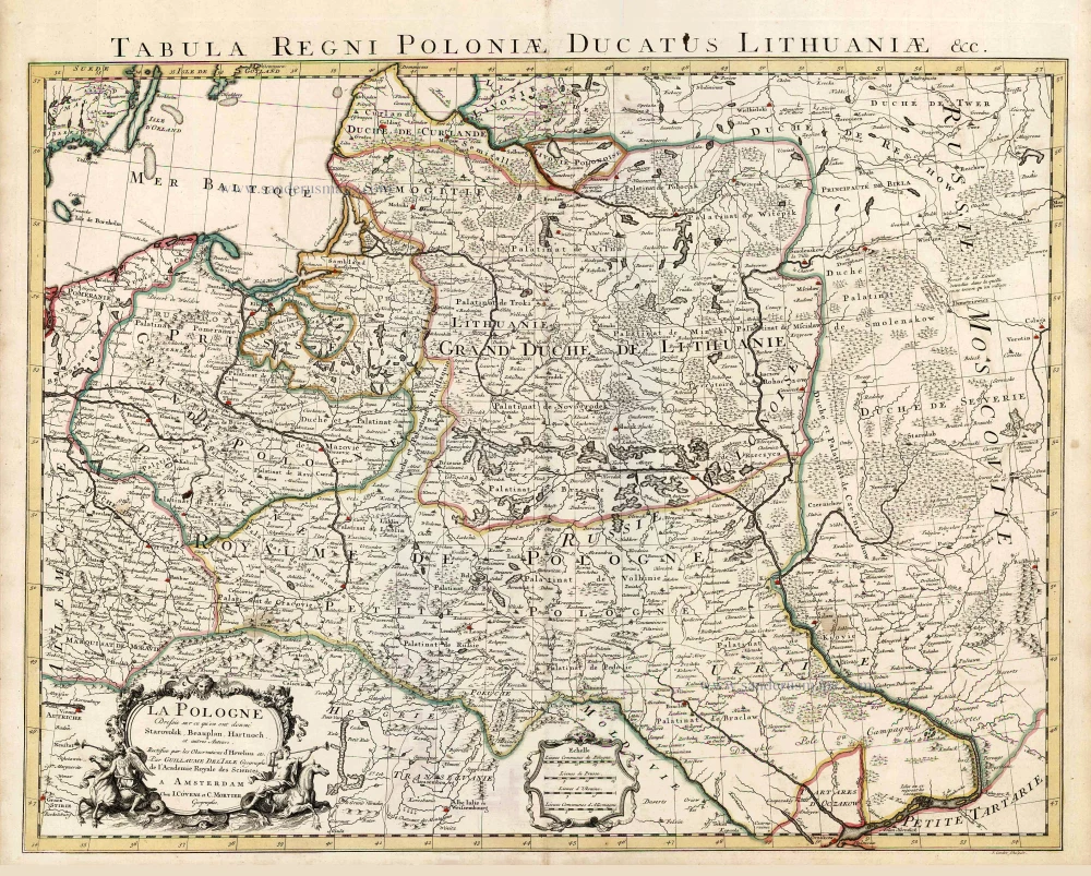
La Pologne Dressée sur ce qu'en ont donné Starovolsk, Beauplan, Hartnoch, et autres auteurs. [Latin title in upper margin:] Tabula Regni Poloniae, Ducatus Lithuaniae &c. 1730
Poland - Lithuania by Guillaume Delisle, published by Covens & Mortier.
[Item number: 25890]

Wratislavia. 1590
Wroclaw (Breslau), by Georg Braun & Frans Hogenberg.
[Item number: 26777]
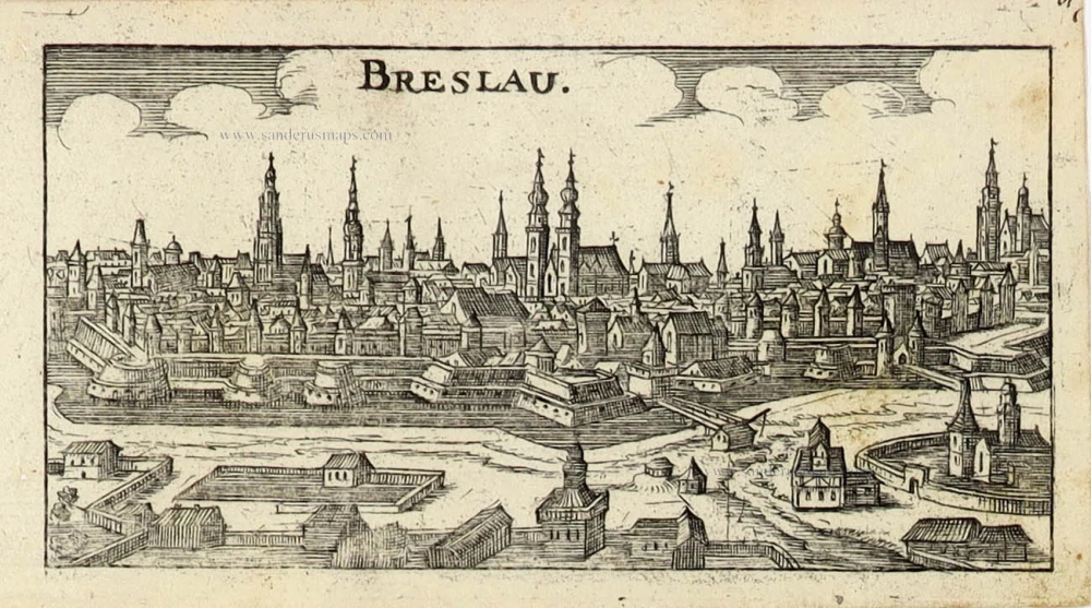
Breslau. 1686
Wroclaw (Breslau) by Christoph Riegel.
[Item number: 31701]

Prospectus quartae partis Circuli et Fori Vratislaviensis per forum cupedinarium versus plateam Albrechtianam spectandi. - Prospect des vierten Theils vom Markt oder Ringe zu Breslau den Naschmarkt hinauf gegen der Albrechts Gassen zusehen. c. 1750
Optical View of Wroclaw (Breslau), by Martin Engelbrecht.
[Item number: 31911]

Prospectus tertia pars Circuli et Fori Vratislaviensis versus domum Staticum s:plateam Viadrinam spectanda. - Prospect des dritten Theils des Ringes in Breßlau gegen der Waag und Oder Gaßen anzusehen. c. 1750
Optical View of Wroclaw (Breslau), by Martin Engelbrecht.
[Item number: 31913]

Prospectus alterius partis fori Vratislaviensis et sic dicti Circuli, à foro foenario verus fornicem Olaviensem contemplandus. - Prospect des andern Theils vom Breslauischen Marckte oder so genänten Ringes vom Neu-Marckt gegen dem Slavischen Schwibogen anzusehen. c. 1750
Optical View of Wroclaw (Breslau), by Martin Engelbrecht.
[Item number: 31914]

Prospectus prima partis Fori Vratislaviensis vel sic dicti Circuli à foro frumentario versus Pontem Fabrorum videndus.. - Prospect des Ersten Theils vom Breslauischen Marckt oder sogenänten Ringes vom Kornmarckte gegen der Schmide Brucken anzusehen. c. 1750
Optical View of Wroclaw (Breslau), by Martin Engelbrecht.
[Item number: 31915]

Very rare suite of views of Wroclaw (Breslau)
Prospectus prima partis Fori Vratislaviensis vel sic dicti Circuli à foro frumentario versus Pontem Fabrorum videndus.. - Prospect des Ersten Theils vom Breslauischen Marckt oder sogenänten Ringes vom Kornmarckte gegen der Schmide Brucken anzusehen. c. 1750
Marketplace of Wroclaw (Breslau), by Martin Engelbrecht.
[Item number: 31918]
new