
Black Sea by François Santini 1776-79
Francesco and Paolo Santini (c.1729-1793)
Francesco Santini, a Venetian publisher, acquired the printing plates of Vaugondy’s Atlas Universel …, a commercial and cartographic success, with widespread influence on mapmakers throughout Europe. Together with his brother Paolo, he commissioned a new set of plates and reissued the atlas in 1776. The following year, Paolo Santini assigned all his publication rights to M. Remondini, who in 1777 reissued the same atlas but with his name.
Gilles and Didier Robert de Vaugondy
Gilles Robert de Vaugondy (1688-1766) and his son Didier Robert de Vaugondy (1723-1786) were leading cartographers in France during the 18th century. They served both as geographer to the king of France. The father, Gilles is also known as ‘Le Sieur’ or ‘Monsieur Robert’. He descended from the Nicolas Sanson family through Sanson's grandson Pierre Moulard-Sanson, from whom he inherited Sanson's cartographic material. After Hubert Jaillot died in 1712, the de Vaugondy's acquired numerous copies of his maps and plates, which formed the basis of their beautiful Atlas Universel (1757).
Their business flourished from 1731 to 1778. They made a substantial contribution to the world of cartography.
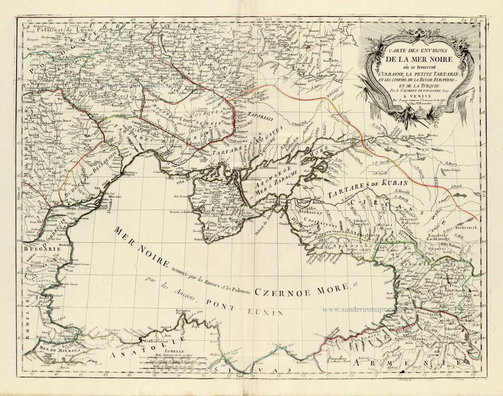
Carte des Environs de la Mer Noire où se Trouvent l'Ukrayne, la Petite Tartarie, et les Confins de la Russie Européene, et de la Turquie.
Item Number: 28090 Authenticity Guarantee
Category: Antique maps > Europe > Eastern Europe
Old, antique map of the Black Sea, by Francesco Santini.
Title: Carte des Environs de la Mer Noire où se Trouvent l'Ukrayne, la Petite Tartarie, et les Confins de la Russie Européene, et de la Turquie.
Par le Sr Robert de Vaugondy Géog.
A Venise, Par François Santini, rue Ste Justine près la dite Eglise.
Chez Mr Remondini.
Cartographer: Robert de Vaugondy.
Date of the first edition: 1776-79.
Date of this map: 1776-79.
Copper engraving, printed on paper.
Size (not including margins): 490 x 640mm (19.29 x 25.2 inches).
Verso: Blank.
Condition: Original coloured in outline, excellent.
Condition Rating: A+.
From: Atlas Universel dressé sur les meilleures cartes modernes. Venice, Remondini, 1776-79.
Francesco and Paolo Santini (c.1729-1793)
Francesco Santini, a Venetian publisher, acquired the printing plates of Vaugondy’s Atlas Universel …, a commercial and cartographic success, with widespread influence on mapmakers throughout Europe. Together with his brother Paolo, he commissioned a new set of plates and reissued the atlas in 1776. The following year, Paolo Santini assigned all his publication rights to M. Remondini, who in 1777 reissued the same atlas but with his name.
Gilles and Didier Robert de Vaugondy
Gilles Robert de Vaugondy (1688-1766) and his son Didier Robert de Vaugondy (1723-1786) were leading cartographers in France during the 18th century. They served both as geographer to the king of France. The father, Gilles is also known as ‘Le Sieur’ or ‘Monsieur Robert’. He descended from the Nicolas Sanson family through Sanson's grandson Pierre Moulard-Sanson, from whom he inherited Sanson's cartographic material. After Hubert Jaillot died in 1712, the de Vaugondy's acquired numerous copies of his maps and plates, which formed the basis of their beautiful Atlas Universel (1757).
Their business flourished from 1731 to 1778. They made a substantial contribution to the world of cartography.
Related items
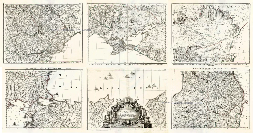
Carte de la Partie Septentrionale de l'Empire Otoman Contenant la Crimée, la Moldavie, la Valakie, la Bulgarie, avec la Nouvelle Russie, les Gouvernement d'Astracan, et de Voronez, les Tatares Cosaques &. 1776-79
Black Sea and surroundings, by Francesco Santini.
[Item number: 26973]
With rare old colour
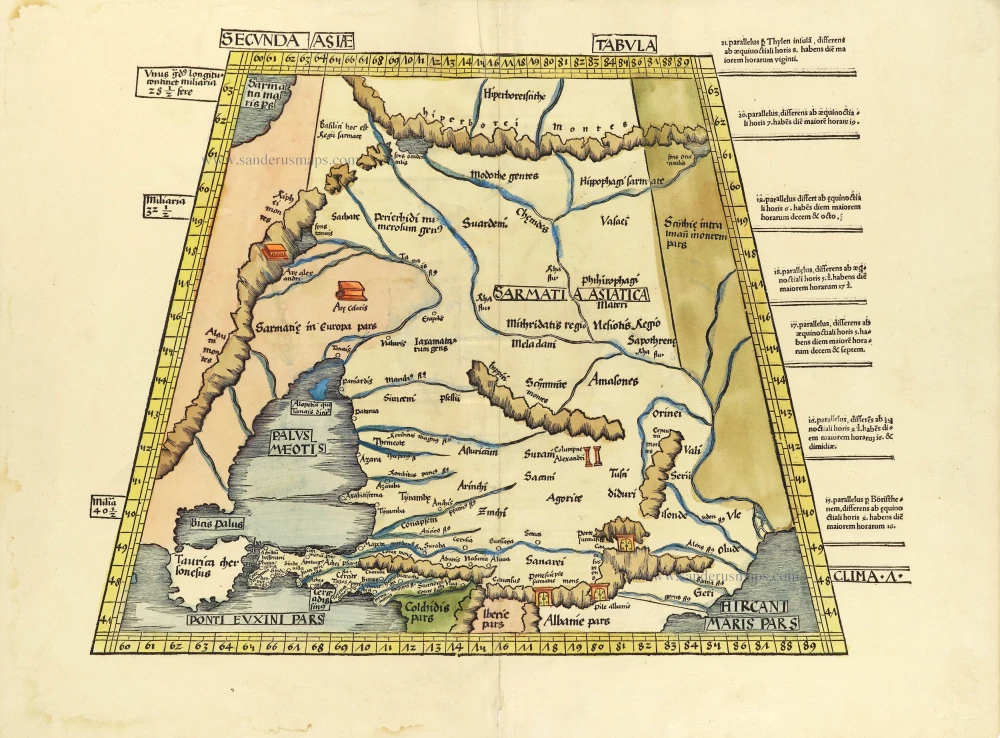
Secunda Asiae Tabula. 1513
Russia and Caucasus by Martin Waldseemüller.
[Item number: 28794]