
Lviv in Ukraine, by Georg Braun and Frans Hogenberg. 1618
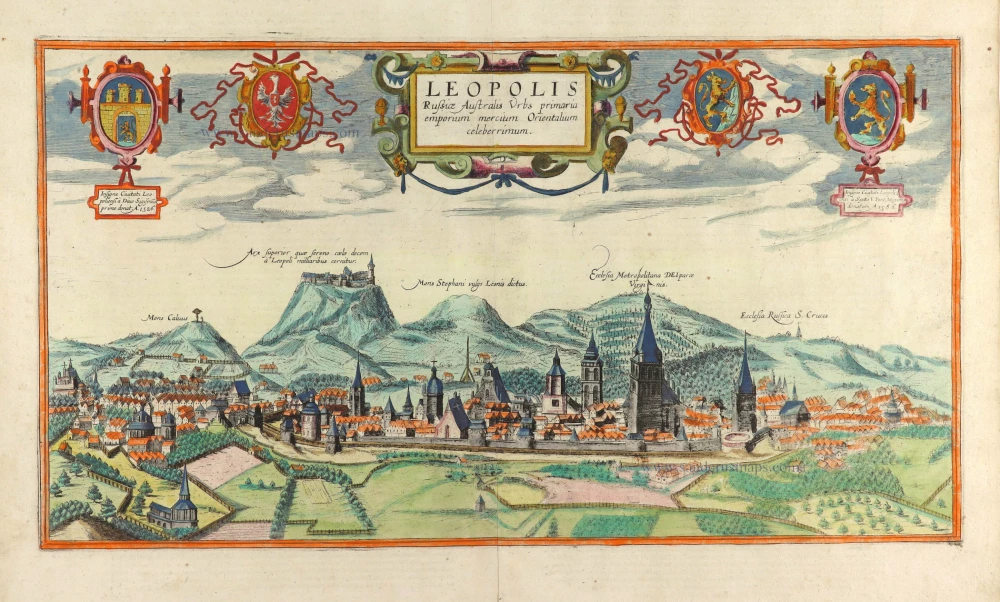


CARTOUCHE CENTRE: Lviv, the capital of south Russia, is a famous trading centre for Oriental goods.
CARTOUCHE LEFT: The Coat of Arms of Lviv was first granted by Sigismund in 1526.
CARTOUCHE RIGHT: Coat of arms of Lviv, granted by Pope Sixtus in 1586.
COMMENTARY BY BRAUN (on verso): "Lviv is exceedingly well fortified with a double deep moat, a strong wall and many towers. It also has an imposing arsenal with all kinds of weaponry in it. In addition, it is a vast trade city with very noble and friendly burghers. The city has a Catholic archbishop and two others, Russian Orthodox and Armenian. There are also two castles, one of which is in the town, the other outside it on a high mountain."
The engraving shows a view of the city from the west with a range of hills in the background. The 14th-century Roman Catholic cathedral of the Assumption of the Blessed Virgin Mary stands out among the many church spires. On the right, directly next to it, is the Russian Orthodox Cathedral of the Holy Cross. Precisely in the centre, with a high roof and a short tower, is the Armenian Cathedral of St Mary, which dates from the 14th century. On a hill towering above the city is the High Castle. The foundation and name of the city go back to a castle built in the mid-13th century by Daniel of Galicia for his son Lev (which means "lion" in Ukrainian). Lviv fell to Poland in 1340, was granted a municipal charter in 1356 by Casimir I and became the seat of an archbishop in 1412. As a trade city, Lviv became a melting pot of many nationalities and, at the same time, an important centre of Polish culture. From 1772 to 1918, Lviv, called Lemberg in German, belonged to Austria-Hungary and was the capital of Galicia.
Braun G. & Hogenberg F. and the Civitates Orbis Terrarum.
The Civitates Orbis Terrarum, or the "Braun & Hogenberg", is a six-volume town atlas and the most excellent book of town views and plans ever published: 363 engravings, sometimes beautifully coloured. It was one of the best-selling works in the last quarter of the 16th century. Georg Braun wrote the text accompanying the plans and views on the verso. Many plates were engraved after the original drawings of a professional artist, a professional artist, Joris Hoefnagel (1542-1600). The first volume was published in Latin in 1572, and the sixth in 1617. Frans Hogenberg created the tables for volumes I through IV, and Simon van den Neuwel made those for volumes V and VI. Other contributors were cartographers Daniel Freese and Heinrich Rantzau. Works by Jacob van Deventer, Sebastian Münster, and Johannes Stumpf were also used. Translations appeared in German and French.
Following the original publication of Volume 1 of the Civitates in 1572, seven further editions of 1575, 1577, 1582, 1588, 1593, 1599 and 1612 can be identified. Vol.2, first issued in 1575, was followed by further editions in 1597 and 1612. The subsequent volumes appeared in 1581, 1588, 1593, 1599 and 1606. The German translation of the first volume appeared from 1574 on, and the French edition from 1575 on.
Several printers were involved: Theodor Graminaeus, Heinrich von Aich, Gottfried von Kempen, Johannis Sinniger, Bertram Buchholtz and Peter von Brachel, who all worked in Cologne.
Georg Braun (1541-1622)
Georg Braun was born in Cologne in 1541. After his studies in Cologne, he entered the Jesuit Order as a novice. 1561, he obtained his bachelor's degree, and in 1562, he received his Magister Artium. Although he left the Jesuit Order, he studied theology, gaining a licentiate in theology.
Frans Hogenberg (1535-1590)
Frans Hogenberg was a Flemish and German painter, engraver, and mapmaker. He was born in Mechelen as the son of Nicolaas Hogenberg.
By the end of the 1560s, Frans Hogenberg was employed upon Abraham Ortelius's Theatrum Orbis Terrarum, published in 1570; he is named an engraver of numerous maps. In 1568, he was banned from Antwerp by the Duke of Alva and travelled to London, where he stayed a few years before emigrating to Cologne. He immediately embarked on his two most important works, the Civitates, published in 1572 and the Geschichtsblätter, which appeared in several series from 1569 until about 1587.
Thanks to large-scale projects like the Geschichtsblätter and the Civitates, Hogenberg's social circumstances improved with each passing year. He died as a wealthy man in Cologne in 1590.
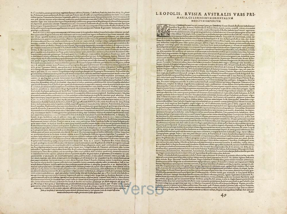
Leopolis Russiae Australis Urbs primaria emporiummercium Orientalium celeberrimum.
Item Number: 29704 Authenticity Guarantee
Category: Antique maps > Europe > Eastern Europe
Old, antique panoramic view of Lviv in Ukraine, by Georg Braun and Frans Hogenberg.
Title: Leopolis Russiae Australis Urbs primaria emporiummercium Orientalium celeberrimum.
Insigne Civitati Leopoli ... ensi à Sixto V. Pont Maximo donatum A 1586.
Date of the first edition: 1617.
Date of this map: 1618.
Copper engraving, printed on paper.
Image size: 280 x 510mm (11.02 x 20.08 inches).
Sheet size: 425 x 555mm (16.73 x 21.85 inches).
Verso: Latin text.
Condition: Original coloured, excellent.
Condition Rating: A+.
From: Civitates Orbis Terrarum. Theatri praecipuarum Totius Mundi Urbium Liber Sextus Anno MDCXVIII. Cologne, Anton Heirat, 1618. (Van der Krogt 4, 41:1.6)
CARTOUCHE CENTRE: Lviv, the capital of south Russia, is a famous trading centre for Oriental goods.
CARTOUCHE LEFT: The Coat of Arms of Lviv was first granted by Sigismund in 1526.
CARTOUCHE RIGHT: Coat of arms of Lviv, granted by Pope Sixtus in 1586.
COMMENTARY BY BRAUN (on verso): "Lviv is exceedingly well fortified with a double deep moat, a strong wall and many towers. It also has an imposing arsenal with all kinds of weaponry in it. In addition, it is a vast trade city with very noble and friendly burghers. The city has a Catholic archbishop and two others, Russian Orthodox and Armenian. There are also two castles, one of which is in the town, the other outside it on a high mountain."
The engraving shows a view of the city from the west with a range of hills in the background. The 14th-century Roman Catholic cathedral of the Assumption of the Blessed Virgin Mary stands out among the many church spires. On the right, directly next to it, is the Russian Orthodox Cathedral of the Holy Cross. Precisely in the centre, with a high roof and a short tower, is the Armenian Cathedral of St Mary, which dates from the 14th century. On a hill towering above the city is the High Castle. The foundation and name of the city go back to a castle built in the mid-13th century by Daniel of Galicia for his son Lev (which means "lion" in Ukrainian). Lviv fell to Poland in 1340, was granted a municipal charter in 1356 by Casimir I and became the seat of an archbishop in 1412. As a trade city, Lviv became a melting pot of many nationalities and, at the same time, an important centre of Polish culture. From 1772 to 1918, Lviv, called Lemberg in German, belonged to Austria-Hungary and was the capital of Galicia.
Braun G. & Hogenberg F. and the Civitates Orbis Terrarum.
The Civitates Orbis Terrarum, or the "Braun & Hogenberg", is a six-volume town atlas and the most excellent book of town views and plans ever published: 363 engravings, sometimes beautifully coloured. It was one of the best-selling works in the last quarter of the 16th century. Georg Braun wrote the text accompanying the plans and views on the verso. Many plates were engraved after the original drawings of a professional artist, a professional artist, Joris Hoefnagel (1542-1600). The first volume was published in Latin in 1572, and the sixth in 1617. Frans Hogenberg created the tables for volumes I through IV, and Simon van den Neuwel made those for volumes V and VI. Other contributors were cartographers Daniel Freese and Heinrich Rantzau. Works by Jacob van Deventer, Sebastian Münster, and Johannes Stumpf were also used. Translations appeared in German and French.
Following the original publication of Volume 1 of the Civitates in 1572, seven further editions of 1575, 1577, 1582, 1588, 1593, 1599 and 1612 can be identified. Vol.2, first issued in 1575, was followed by further editions in 1597 and 1612. The subsequent volumes appeared in 1581, 1588, 1593, 1599 and 1606. The German translation of the first volume appeared from 1574 on, and the French edition from 1575 on.
Several printers were involved: Theodor Graminaeus, Heinrich von Aich, Gottfried von Kempen, Johannis Sinniger, Bertram Buchholtz and Peter von Brachel, who all worked in Cologne.
Georg Braun (1541-1622)
Georg Braun was born in Cologne in 1541. After his studies in Cologne, he entered the Jesuit Order as a novice. 1561, he obtained his bachelor's degree, and in 1562, he received his Magister Artium. Although he left the Jesuit Order, he studied theology, gaining a licentiate in theology.
Frans Hogenberg (1535-1590)
Frans Hogenberg was a Flemish and German painter, engraver, and mapmaker. He was born in Mechelen as the son of Nicolaas Hogenberg.
By the end of the 1560s, Frans Hogenberg was employed upon Abraham Ortelius's Theatrum Orbis Terrarum, published in 1570; he is named an engraver of numerous maps. In 1568, he was banned from Antwerp by the Duke of Alva and travelled to London, where he stayed a few years before emigrating to Cologne. He immediately embarked on his two most important works, the Civitates, published in 1572 and the Geschichtsblätter, which appeared in several series from 1569 until about 1587.
Thanks to large-scale projects like the Geschichtsblätter and the Civitates, Hogenberg's social circumstances improved with each passing year. He died as a wealthy man in Cologne in 1590.
Related items
Rade de Sébastopol. Observée par quatre Vapeurs de la Flotte Anglo-Française. / Road of Sebastopol. Overseen by four Steamer of the English and French Fleet. 1854
Sebastopol (Ukraine), by Max Beeger.
[Item number: 27436]
A bird's-eye view of the Town, Harbours & Forts of Odessa. 1854
Odessa (Ukraine), by H. Whittock.
[Item number: 27448]
Plan de la fameuse Bataille donnee aux environs de Poltawa en Ucraine Entre l'Armee de sa Majesté Csarienne Pierre I. Empereur de la Grande Russie et celle de S.M. le Roy de Suede Charles XII. me 27 Juin -8 Jullet 1709. c. 1709
Map of the Battle of Poltawa (Ukraine) in 1709, by Pierre Husson.
[Item number: 29587]