
Szczecin in Poland, by Georg Braun and Frans Hogenberg. 1588
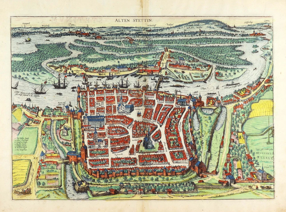


COMMENTARY BY BRAUN (on verso): "Before the Christian faith was accepted, the Wendish language was spoken there, and the region was called Pomerzi in their local language, i.e. Wendish. The region is inhabited by indigenous peoples governed by their rulers and has never been subject to foreign domination. [...] It is provided with fine towns, yet the most beautiful of them is by the shores of the sea and only a few of them inland, among them Stettin, or Sedin, which, as is believed, derives its name from the Sedinis peoples and is the most notable of those towns situated on this side of the River Oder."
Szczecin is seen from the west in a bird's-eye view. All important buildings, squares and streets have been drawn in accurate detail. Not Christianized until the 12th century, Szczecin grew out of a Wendish (Sorb) village and two German mercantile settlements, as indicated by St James's church. After being declared a Free Imperial City in 1243, the town hall and, significantly next to it, the church of St Nicholas, consecrated to the patron saint of German merchants, were erected. The city joined the Hansa in 1278. When the castle was built in 1309, Szczecin became the capital of the Duchy of Pomerania. In 1630, Szczecin fell to Sweden, but from 1720, it belonged to Prussia, becoming its most important port in the late 18th century. Severely damaged in the war, Szczecin, on the west bank of the Oder, did not become Polish until July 1945. With a population of 411,000, Szczecin is the seventh-largest city in Poland. (Taschen)
Braun G. & Hogenberg F. and the Civitates Orbis Terrarum.
The Civitates Orbis Terrarum, also known as the 'Braun & Hogenberg', is a six-volume town atlas and the most excellent book of town views and plans ever published: 363 engravings, sometimes beautifully coloured. It was one of the best-selling works in the last quarter of the 16th century. Georg Braun, a skilled writer, wrote the text accompanying the plans and views on the verso. Many plates were engraved after the original drawings of a professional artist, Joris Hoefnagel (1542-1600). The first volume was published in Latin in 1572 and the sixth in 1617. Frans Hogenberg, a talented engraver, created the tables for volumes I through IV, and Simon van den Neuwel made those for volumes V and VI. Other contributors were cartographers Daniel Freese and Heinrich Rantzau, who provided valuable geographical information. Works by Jacob van Deventer, Sebastian Münster, and Johannes Stumpf were also used as references. Translations appeared in German and French, making the atlas accessible to a broader audience.
Since its original publication of volume 1 in 1572, the Civitates Orbis Terrarum has left an indelible mark on the history of cartography. Seven more editions followed the first volume in 1575, 1577, 1582, 1588, 1593, 1599, and 1612. Vol.2, initially released in 1575, saw subsequent editions in 1597 and 1612. The subsequent volumes, each a treasure trove of historical insights, graced the world in 1581, 1588, 1593, 1599, and 1606. The German translation of the first volume, a testament to its widespread appeal, debuted in 1574, followed by the French edition in 1575.
Several printers were involved: Theodor Graminaeus, Heinrich von Aich, Gottfried von Kempen, Johannis Sinniger, Bertram Buchholtz, and Peter von Brachel, all of whom worked in Cologne.
Georg Braun (1541-1622)
Georg Braun, the author of the text accompanying the plans and views in the Civitates Orbis Terrarum, was born in Cologne in 1541. After his studies in Cologne, he entered the Jesuit Order as a novice, indicating his commitment to learning and intellectual pursuits. In 1561, he obtained his bachelor's degree; in 1562, he received his Magister Artium, further demonstrating his academic achievements. Although he left the Jesuit Order, he continued his studies in theology, gaining a licentiate in theology. His theological background likely influenced the content and tone of the text in the Civitates Orbis Terrarum, adding a unique perspective to the work.
Frans Hogenberg (1535-1590)
Frans Hogenberg was a Flemish and German painter, engraver, and mapmaker. He was born in Mechelen as the son of Nicolaas Hogenberg.
By the end of the 1560s, Frans Hogenberg was employed upon Abraham Ortelius's Theatrum Orbis Terrarum, published in 1570; he is named an engraver of numerous maps. In 1568, he was banned from Antwerp by the Duke of Alva and travelled to London, where he stayed a few years before emigrating to Cologne. He immediately embarked on his two most important works, the Civitates, published in 1572 and the Geschichtsblätter, which appeared in several series from 1569 until about 1587.
Thanks to large-scale projects like the Geschichtsblätter and the Civitates, Hogenberg's social circumstances improved with each passing year. He died as a wealthy man in Cologne in 1590.
Alten Stettin
Item Number: 29161 Authenticity Guarantee
Category: Antique maps > Europe > Eastern Europe
Old, antique bird’s-eye view plan of Szczecin in Poland, by Georg Braun and Frans Hogenberg.
Title: Alten Stettin
Date of the first edition: 1588.
Date of this map: 1588.
Copper engraving, printed on paper.
Map size: 340 x 480mm (13.39 x 18.9 inches).
Sheet size: 395 x 530mm (15.55 x 20.87 inches).
Verso: Latin text.
Condition: Original coloured, excellent.
Condition Rating: A+.
From: Liber Quartus Urbium Praecipuarum Totius Mundi. Cologne, 1588. (Koeman, B&H4, Van der Krogt 4, 41:1.4)
COMMENTARY BY BRAUN (on verso): "Before the Christian faith was accepted, the Wendish language was spoken there, and the region was called Pomerzi in their local language, i.e. Wendish. The region is inhabited by indigenous peoples governed by their rulers and has never been subject to foreign domination. [...] It is provided with fine towns, yet the most beautiful of them is by the shores of the sea and only a few of them inland, among them Stettin, or Sedin, which, as is believed, derives its name from the Sedinis peoples and is the most notable of those towns situated on this side of the River Oder."
Szczecin is seen from the west in a bird's-eye view. All important buildings, squares and streets have been drawn in accurate detail. Not Christianized until the 12th century, Szczecin grew out of a Wendish (Sorb) village and two German mercantile settlements, as indicated by St James's church. After being declared a Free Imperial City in 1243, the town hall and, significantly next to it, the church of St Nicholas, consecrated to the patron saint of German merchants, were erected. The city joined the Hansa in 1278. When the castle was built in 1309, Szczecin became the capital of the Duchy of Pomerania. In 1630, Szczecin fell to Sweden, but from 1720, it belonged to Prussia, becoming its most important port in the late 18th century. Severely damaged in the war, Szczecin, on the west bank of the Oder, did not become Polish until July 1945. With a population of 411,000, Szczecin is the seventh-largest city in Poland. (Taschen)
Braun G. & Hogenberg F. and the Civitates Orbis Terrarum.
The Civitates Orbis Terrarum, also known as the 'Braun & Hogenberg', is a six-volume town atlas and the most excellent book of town views and plans ever published: 363 engravings, sometimes beautifully coloured. It was one of the best-selling works in the last quarter of the 16th century. Georg Braun, a skilled writer, wrote the text accompanying the plans and views on the verso. Many plates were engraved after the original drawings of a professional artist, Joris Hoefnagel (1542-1600). The first volume was published in Latin in 1572 and the sixth in 1617. Frans Hogenberg, a talented engraver, created the tables for volumes I through IV, and Simon van den Neuwel made those for volumes V and VI. Other contributors were cartographers Daniel Freese and Heinrich Rantzau, who provided valuable geographical information. Works by Jacob van Deventer, Sebastian Münster, and Johannes Stumpf were also used as references. Translations appeared in German and French, making the atlas accessible to a broader audience.
Since its original publication of volume 1 in 1572, the Civitates Orbis Terrarum has left an indelible mark on the history of cartography. Seven more editions followed the first volume in 1575, 1577, 1582, 1588, 1593, 1599, and 1612. Vol.2, initially released in 1575, saw subsequent editions in 1597 and 1612. The subsequent volumes, each a treasure trove of historical insights, graced the world in 1581, 1588, 1593, 1599, and 1606. The German translation of the first volume, a testament to its widespread appeal, debuted in 1574, followed by the French edition in 1575.
Several printers were involved: Theodor Graminaeus, Heinrich von Aich, Gottfried von Kempen, Johannis Sinniger, Bertram Buchholtz, and Peter von Brachel, all of whom worked in Cologne.
Georg Braun (1541-1622)
Georg Braun, the author of the text accompanying the plans and views in the Civitates Orbis Terrarum, was born in Cologne in 1541. After his studies in Cologne, he entered the Jesuit Order as a novice, indicating his commitment to learning and intellectual pursuits. In 1561, he obtained his bachelor's degree; in 1562, he received his Magister Artium, further demonstrating his academic achievements. Although he left the Jesuit Order, he continued his studies in theology, gaining a licentiate in theology. His theological background likely influenced the content and tone of the text in the Civitates Orbis Terrarum, adding a unique perspective to the work.
Frans Hogenberg (1535-1590)
Frans Hogenberg was a Flemish and German painter, engraver, and mapmaker. He was born in Mechelen as the son of Nicolaas Hogenberg.
By the end of the 1560s, Frans Hogenberg was employed upon Abraham Ortelius's Theatrum Orbis Terrarum, published in 1570; he is named an engraver of numerous maps. In 1568, he was banned from Antwerp by the Duke of Alva and travelled to London, where he stayed a few years before emigrating to Cologne. He immediately embarked on his two most important works, the Civitates, published in 1572 and the Geschichtsblätter, which appeared in several series from 1569 until about 1587.
Thanks to large-scale projects like the Geschichtsblätter and the Civitates, Hogenberg's social circumstances improved with each passing year. He died as a wealthy man in Cologne in 1590.
Related items

Die Stat Swybuschin in Nider Schlesien. 1596
Poland - Swiebodzin, by Braun & Hogenberg.
[Item number: 22102]

Nissa Silesior Sedes Episcopalis [on sheet with] Liginicium c. 1625
Nysa and Legnica (Poland), by Georg Braun and Frans Hogenberg.
[Item number: 24584]

Lovicensis Civitas quae est Archiepiscopa. 1617-18
Lowicz by Georg Braun & Frans Hogenberg
[Item number: 29282]

Poloniae Nova et Descriptio. 1653
Poland by Johannes Janssonius.
[Item number: 30345]