
Orléans - Bourges, by Braun & Hogenberg. 1582

ORLÉANS
COMMENTARY BY BRAUN: "Orléans is a city in France on the Loire. In the direction of Paris, where the city spreads out upon a hill, stood the Church of the Holy Cross before its recent destruction by the Huguenots. Orléans has clean, healthy air and is graced with excellent schools. Law is the subject most commonly studied. So many erudite men have gone forth from these schools that there is not enough space here to tell of them all. Among others, the important Bertrandus, Archbishop of Bordeaux, who later became Pope in Rome and took on the name Clement V."
Seen from the south, the view shows Orléans on the far side of the Loire. In the centre, rising above the city, is Sainte-Croix Cathedral, which was built around the end of the 13th century. The destruction referred to in the text can be dated to 24 March 1568; reconstruction was begun under Henry IV around 1600. Since the early 14th century, Orléans had played a key role in armed conflicts, which came to a climax when the city was besieged by the English and subsequently liberated by Joan of Arc in 1429. The University d'Orléans was founded in 1235, 200 years after Pope Clement V; John Calvin also studied law here.
BOURGES
COMMENTARY BY BRAUN: "Today, one can still see the entire wall of the Old Town of Avaricum, which is so strongly fortified that no tools can pull it down, so that it must therefore be left standing. Bourges was expanded by degrees. At one place towards the southeast, there is an opening, secured by strong walls and fortified ramparts. From them one can see a long way, but in particular there is a high tower here from which one can see four miles around and which is therefore called the Great Tower."
The view shows Bourges from the south on the far side of the River Auron. The name of the city is derived from the Celtic tribe of the Bituriges, whose chief town, Avaricum, was here. The well-fortified walls, the remains of which can still be seen today, date from this time. In 1137, Louis VII was crowned king of France in Bourges. Under him and his successor Philip II, the city was expanded, and a new fortification system was built. The fortress-like Great Tower (12) was destroyed in 1653 in the course of the revolt against absolutism known as the Fronde. Towards the end of the 12th century, construction began on the cathedral of Saint-Étienne (9), one of the earliest examples of High Gothic architecture, with stained-glass windows from the 13th century. The left side of the view is mainly dominated by the palace of Jacques Coeur (5). Coeur was an important merchant and Finance Minister under Charles II. (Taschen)
Braun G. & Hogenberg F. and the Civitates Orbis Terrarum.
The Civitates Orbis Terrarum, also known as the 'Braun & Hogenberg', is a six-volume town atlas and the most excellent book of town views and plans ever published: 363 engravings, sometimes beautifully coloured. It was one of the best-selling works in the last quarter of the 16th century. Georg Braun, a skilled writer, wrote the text accompanying the plans and views on the verso. Many plates were engraved after the original drawings of a professional artist, Joris Hoefnagel (1542-1600). The first volume was published in Latin in 1572 and the sixth in 1617. Frans Hogenberg, a talented engraver, created the tables for volumes I through IV, and Simon van den Neuwel made those for volumes V and VI. Other contributors were cartographers Daniel Freese and Heinrich Rantzau, who provided valuable geographical information. Works by Jacob van Deventer, Sebastian Münster, and Johannes Stumpf were also used as references. Translations appeared in German and French, making the atlas accessible to a broader audience.
Since its original publication of volume 1 in 1572, the Civitates Orbis Terrarum has left an indelible mark on the history of cartography. Seven more editions followed the first volume in 1575, 1577, 1582, 1588, 1593, 1599, and 1612. Vol.2, initially released in 1575, saw subsequent editions in 1597 and 1612. The subsequent volumes, each a treasure trove of historical insights, graced the world in 1581, 1588, 1593, 1599, and 1606. The German translation of the first volume, a testament to its widespread appeal, debuted in 1574, followed by the French edition in 1575.
Several printers were involved: Theodor Graminaeus, Heinrich von Aich, Gottfried von Kempen, Johannis Sinniger, Bertram Buchholtz, and Peter von Brachel, all of whom worked in Cologne.
Georg Braun (1541-1622)
Georg Braun, the author of the text accompanying the plans and views in the Civitates Orbis Terrarum, was born in Cologne in 1541. After his studies in Cologne, he entered the Jesuit Order as a novice, indicating his commitment to learning and intellectual pursuits. In 1561, he obtained his bachelor's degree; in 1562, he received his Magister Artium, further demonstrating his academic achievements. Although he left the Jesuit Order, he continued his studies in theology, gaining a licentiate in theology. His theological background likely influenced the content and tone of the text in the Civitates Orbis Terrarum, adding a unique perspective to the work.
Frans Hogenberg (1535-1590)
Frans Hogenberg was a Flemish and German painter, engraver, and mapmaker. He was born in Mechelen as the son of Nicolaas Hogenberg.
By the end of the 1560s, Frans Hogenberg was employed upon Abraham Ortelius's Theatrum Orbis Terrarum, published in 1570; he is named an engraver of numerous maps. In 1568, he was banned from Antwerp by the Duke of Alva and travelled to London, where he stayed a few years before emigrating to Cologne. He immediately embarked on his two most important works, the Civitates, published in 1572 and the Geschichtsblätter, which appeared in several series from 1569 until about 1587.
Thanks to large-scale projects like the Geschichtsblätter and the Civitates, Hogenberg's social circumstances improved with each passing year. He died as a wealthy man in Cologne in 1590.
Orleans [on sheet with:] Bourges
Item Number: 894 Authenticity Guarantee
Category: Antique maps > Europe > France - Cities
Orléans - Bourges, by Braun & Hogenberg.
Title: Orleans [on sheet with:] Bourges
Date of the first edition: 1575.
Date of this map: 1582.
Copper engraving, printed on paper.
Size (not including margins): 370 x 465mm (14½ x 18¼ inches).
Verso: Latin text.
Condition: Original coloured, small repair at centre fold.
Condition Rating: A.
From: Civitates Orbis Terrarum, Liber Secundus. Köln, Gottfried von Kempen, 1582. (Van der Krogt 4, 41:1.2)
ORLÉANS
COMMENTARY BY BRAUN: "Orléans is a city in France on the Loire. In the direction of Paris, where the city spreads out upon a hill, stood the Church of the Holy Cross before its recent destruction by the Huguenots. Orléans has clean, healthy air and is graced with excellent schools. Law is the subject most commonly studied. So many erudite men have gone forth from these schools that there is not enough space here to tell of them all. Among others, the important Bertrandus, Archbishop of Bordeaux, who later became Pope in Rome and took on the name Clement V."
Seen from the south, the view shows Orléans on the far side of the Loire. In the centre, rising above the city, is Sainte-Croix Cathedral, which was built around the end of the 13th century. The destruction referred to in the text can be dated to 24 March 1568; reconstruction was begun under Henry IV around 1600. Since the early 14th century, Orléans had played a key role in armed conflicts, which came to a climax when the city was besieged by the English and subsequently liberated by Joan of Arc in 1429. The University d'Orléans was founded in 1235, 200 years after Pope Clement V; John Calvin also studied law here.
BOURGES
COMMENTARY BY BRAUN: "Today, one can still see the entire wall of the Old Town of Avaricum, which is so strongly fortified that no tools can pull it down, so that it must therefore be left standing. Bourges was expanded by degrees. At one place towards the southeast, there is an opening, secured by strong walls and fortified ramparts. From them one can see a long way, but in particular there is a high tower here from which one can see four miles around and which is therefore called the Great Tower."
The view shows Bourges from the south on the far side of the River Auron. The name of the city is derived from the Celtic tribe of the Bituriges, whose chief town, Avaricum, was here. The well-fortified walls, the remains of which can still be seen today, date from this time. In 1137, Louis VII was crowned king of France in Bourges. Under him and his successor Philip II, the city was expanded, and a new fortification system was built. The fortress-like Great Tower (12) was destroyed in 1653 in the course of the revolt against absolutism known as the Fronde. Towards the end of the 12th century, construction began on the cathedral of Saint-Étienne (9), one of the earliest examples of High Gothic architecture, with stained-glass windows from the 13th century. The left side of the view is mainly dominated by the palace of Jacques Coeur (5). Coeur was an important merchant and Finance Minister under Charles II. (Taschen)
Braun G. & Hogenberg F. and the Civitates Orbis Terrarum.
The Civitates Orbis Terrarum, also known as the 'Braun & Hogenberg', is a six-volume town atlas and the most excellent book of town views and plans ever published: 363 engravings, sometimes beautifully coloured. It was one of the best-selling works in the last quarter of the 16th century. Georg Braun, a skilled writer, wrote the text accompanying the plans and views on the verso. Many plates were engraved after the original drawings of a professional artist, Joris Hoefnagel (1542-1600). The first volume was published in Latin in 1572 and the sixth in 1617. Frans Hogenberg, a talented engraver, created the tables for volumes I through IV, and Simon van den Neuwel made those for volumes V and VI. Other contributors were cartographers Daniel Freese and Heinrich Rantzau, who provided valuable geographical information. Works by Jacob van Deventer, Sebastian Münster, and Johannes Stumpf were also used as references. Translations appeared in German and French, making the atlas accessible to a broader audience.
Since its original publication of volume 1 in 1572, the Civitates Orbis Terrarum has left an indelible mark on the history of cartography. Seven more editions followed the first volume in 1575, 1577, 1582, 1588, 1593, 1599, and 1612. Vol.2, initially released in 1575, saw subsequent editions in 1597 and 1612. The subsequent volumes, each a treasure trove of historical insights, graced the world in 1581, 1588, 1593, 1599, and 1606. The German translation of the first volume, a testament to its widespread appeal, debuted in 1574, followed by the French edition in 1575.
Several printers were involved: Theodor Graminaeus, Heinrich von Aich, Gottfried von Kempen, Johannis Sinniger, Bertram Buchholtz, and Peter von Brachel, all of whom worked in Cologne.
Georg Braun (1541-1622)
Georg Braun, the author of the text accompanying the plans and views in the Civitates Orbis Terrarum, was born in Cologne in 1541. After his studies in Cologne, he entered the Jesuit Order as a novice, indicating his commitment to learning and intellectual pursuits. In 1561, he obtained his bachelor's degree; in 1562, he received his Magister Artium, further demonstrating his academic achievements. Although he left the Jesuit Order, he continued his studies in theology, gaining a licentiate in theology. His theological background likely influenced the content and tone of the text in the Civitates Orbis Terrarum, adding a unique perspective to the work.
Frans Hogenberg (1535-1590)
Frans Hogenberg was a Flemish and German painter, engraver, and mapmaker. He was born in Mechelen as the son of Nicolaas Hogenberg.
By the end of the 1560s, Frans Hogenberg was employed upon Abraham Ortelius's Theatrum Orbis Terrarum, published in 1570; he is named an engraver of numerous maps. In 1568, he was banned from Antwerp by the Duke of Alva and travelled to London, where he stayed a few years before emigrating to Cologne. He immediately embarked on his two most important works, the Civitates, published in 1572 and the Geschichtsblätter, which appeared in several series from 1569 until about 1587.
Thanks to large-scale projects like the Geschichtsblätter and the Civitates, Hogenberg's social circumstances improved with each passing year. He died as a wealthy man in Cologne in 1590.
Related items
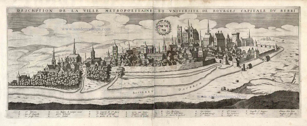
Description de la Ville Metropolitaine et Université de Bourges Capitale du Berri. 1648
Bourges by Jean Boisseau.
[Item number: 25649]
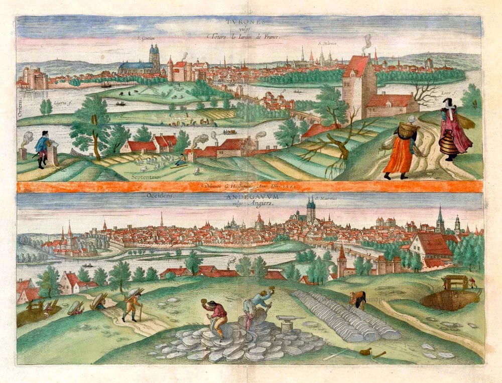
Turones vulgo Tours, le Iardin de France. [on sheet with:] Andegavum vulgo Angiers. c. 1610
Tours and Angers, by Georg Braun and Frans Hogenberg.
[Item number: 25956]
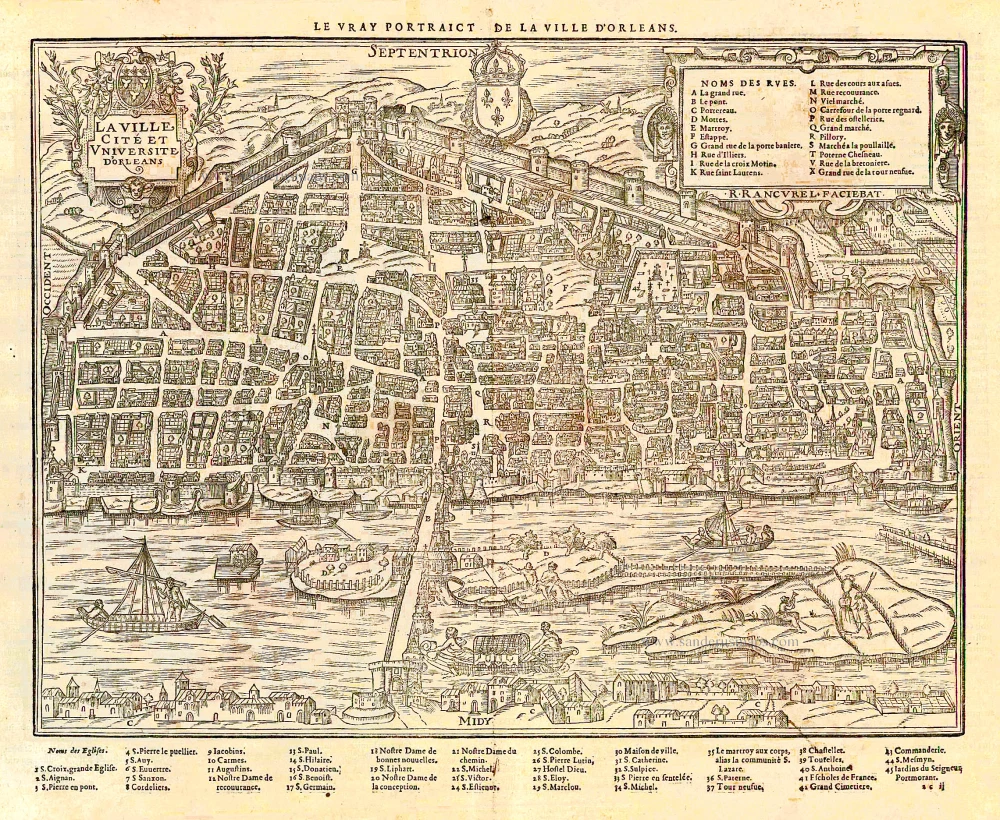
La ville, cité et Université d'Orleans. - [Au-dessus de la carte:] Le vray Portraict de la Ville d'Orleans. 1575
Orléans, by François de Belleforest.
[Item number: 27172]
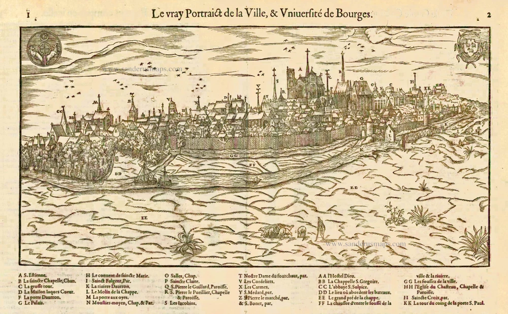
Le vray Portraict de la Ville, & Université de Bourges. 1575
Bourges, by François de Belleforest.
[Item number: 27180]