
Rouen, Nîmes, and Bordeaux, by Georg Braun and Frans Hogenberg. 1612

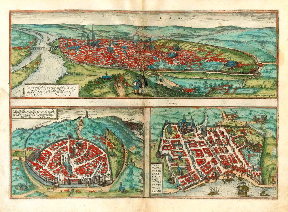
ROUEN
CARTOUCHE: Rotomagus or Rouen, the capital of Normandy.
COMMENTARY BY BRAUN (on verso): "Rouen is the capital of Normandy; to the south, it lies beside the Seine with its plentiful river traffic, to the north beside high hills displaying volcanic activity. Since the city is surrounded by fertile farmland, Emperor Julius Cesar surrounded it early on with massive strong walls, and Roman soldiers were stationed there to protect the whole province. This city is particularly distinguished by its magnificent archbishop's house, splendid monasteries, palace and town hall, the bridge with squared stones, the main church and the three towers, etc."
The city's favourable position between the Seine to the south and the hills in the north is clearly illustrated in this view, which is seen from the east from an ideal hill and also shows the intact city walls from the Roman era. The staffage emphasizes the course taken by the road from Paris leading into the city.
NÎMES
CARTOUCHE: Nîmes, the ancient city in the Roman province of Gallia Narbonensis.
COMMENTARY BY BRAUN (on verso): "Nemausus, called Nismes in the vernacular, possesses a games arena that is called the Amphitheatrum, old tumbledown houses and ruins and also the Temple of Hadrian. There is also a main church dedicated to Our Lady that was built with huge squared stones and is extremely imposing. Three short miles from Nîmes, a wondrous bridge crosses the River Gardon, built with arches on three levels, of which one allows beasts and people to cross, the second carries the water conduit."
Nîmes was a flourishing settlement even in Celtic times and due to its favourable location on the Via Domitia, a major transportation route linking Italy and Spain, was developed into the capital of Narbonensis province. Amongst other things, it was given a 7-km-long city wall and the dominant Tour Magne watchtower (top centre). Also stemming from Roman times is the imposing amphitheatre (left), which could seat some 23,000 spectators and is used for performances even today. Its façade, comprising two storeys, each with 60 arches, is clearly recognizable, even in foreshortening. Above the cathedral and clock tower lies the Maison Carrée, a Roman temple built by Marcus Vipsanius Agrippa around 19 B.C. The 49-m-high Pont du Gard aqueduct, mentioned by Braun and visible top right, is an important work of Roman civil engineering.
BORDEAUX
CARTOUCHE: Faithful illustration of the city of Bordeaux in Aquitaine.
COMMENTARY BY BRAUN (on verso): "Burdegal is rightly called the capital of Aquitaine. Firstly due to its great age, secondly due to its magnificent houses, thirdly because it is considered a bulwark of France on account of its well-fortified castle and its sustained resistance. This will also be ackowledged by the English, who long besieged Bordeaux in order to conquer its fortress, as they have done in other cities with less difficulty."
The fortifications were built by Charles VII of France only following the reconquest of Bordeaux in 1452. Shown on a smaller scale to the right of the château du Hâ is the Gothic cathedral of Saint-André with its free-standing clock tower, the Tour Pey-Berland. Outside the city walls lie the ruins of the Roman amphitheatre.
Braun G. & Hogenberg F. and the Civitates Orbis Terrarum.
The Civitates Orbis Terrarum, also known as the 'Braun & Hogenberg', is a six-volume town atlas and the most excellent book of town views and plans ever published: 363 engravings, sometimes beautifully coloured. It was one of the best-selling works in the last quarter of the 16th century. Georg Braun, a skilled writer, wrote the text accompanying the plans and views on the verso. Many plates were engraved after the original drawings of a professional artist, Joris Hoefnagel (1542-1600). The first volume was published in Latin in 1572 and the sixth in 1617. Frans Hogenberg, a talented engraver, created the tables for volumes I through IV, and Simon van den Neuwel made those for volumes V and VI. Other contributors were cartographers Daniel Freese and Heinrich Rantzau, who provided valuable geographical information. Works by Jacob van Deventer, Sebastian Münster, and Johannes Stumpf were also used as references. Translations appeared in German and French, making the atlas accessible to a broader audience.
Since its original publication of volume 1 in 1572, the Civitates Orbis Terrarum has left an indelible mark on the history of cartography. Seven more editions followed the first volume in 1575, 1577, 1582, 1588, 1593, 1599, and 1612. Vol.2, initially released in 1575, saw subsequent editions in 1597 and 1612. The subsequent volumes, each a treasure trove of historical insights, graced the world in 1581, 1588, 1593, 1599, and 1606. The German translation of the first volume, a testament to its widespread appeal, debuted in 1574, followed by the French edition in 1575.
Several printers were involved: Theodor Graminaeus, Heinrich von Aich, Gottfried von Kempen, Johannis Sinniger, Bertram Buchholtz, and Peter von Brachel, all of whom worked in Cologne.
Georg Braun (1541-1622)
Georg Braun, the author of the text accompanying the plans and views in the Civitates Orbis Terrarum, was born in Cologne in 1541. After his studies in Cologne, he entered the Jesuit Order as a novice, indicating his commitment to learning and intellectual pursuits. In 1561, he obtained his bachelor's degree; in 1562, he received his Magister Artium, further demonstrating his academic achievements. Although he left the Jesuit Order, he continued his studies in theology, gaining a licentiate in theology. His theological background likely influenced the content and tone of the text in the Civitates Orbis Terrarum, adding a unique perspective to the work.
Frans Hogenberg (1535-1590)
Frans Hogenberg was a Flemish and German painter, engraver, and mapmaker. He was born in Mechelen as the son of Nicolaas Hogenberg.
By the end of the 1560s, Frans Hogenberg was employed upon Abraham Ortelius's Theatrum Orbis Terrarum, published in 1570; he is named an engraver of numerous maps. In 1568, he was banned from Antwerp by the Duke of Alva and travelled to London, where he stayed a few years before emigrating to Cologne. He immediately embarked on his two most important works, the Civitates, published in 1572 and the Geschichtsblätter, which appeared in several series from 1569 until about 1587.
Thanks to large-scale projects like the Geschichtsblätter and the Civitates, Hogenberg's social circumstances improved with each passing year. He died as a wealthy man in Cologne in 1590.
Rotomagus, vulgo Roan, Normandiae Metropolis [on sheet with] Nemavsus, Nismes, Civitas Narbonensie Galliae Vetustissima [and] Civitas Burdegalensis in Aquitanea, Genuina Descrip.
Item Number: 22306 Authenticity Guarantee
Category: Antique maps > Europe > France - Cities
Old, antique map with three bird's-eye view plans by Braun and Hogenberg: Rouen, Nîmes and Bordeaux, after Georg Hoefnagel.
Title: Rotomagus, vulgo Roan, Normandiae Metropolis [on sheet with] Nemavsus, Nismes, Civitas Narbonensie Galliae Vetustissima [and] Civitas Burdegalensis in Aquitanea, Genuina Descrip.
Date of the first edition: 1572.
Date of this map: 1612.
Copper engraving, printed on paper.
Size (not including margins): 330 x 485mm (12.99 x 19.09 inches).
Verso: Latin text.
Condition: Uncoloured, excellent.
Condition Rating: A.
From: Civitates Orbis Terrarum, Liber Primus. Cologne, Petrus von Brachel, 1612. (Van der Krogt 4, 41:1.1(1612))
ROUEN
CARTOUCHE: Rotomagus or Rouen, the capital of Normandy.
COMMENTARY BY BRAUN (on verso): "Rouen is the capital of Normandy; to the south, it lies beside the Seine with its plentiful river traffic, to the north beside high hills displaying volcanic activity. Since the city is surrounded by fertile farmland, Emperor Julius Cesar surrounded it early on with massive strong walls, and Roman soldiers were stationed there to protect the whole province. This city is particularly distinguished by its magnificent archbishop's house, splendid monasteries, palace and town hall, the bridge with squared stones, the main church and the three towers, etc."
The city's favourable position between the Seine to the south and the hills in the north is clearly illustrated in this view, which is seen from the east from an ideal hill and also shows the intact city walls from the Roman era. The staffage emphasizes the course taken by the road from Paris leading into the city.
NÎMES
CARTOUCHE: Nîmes, the ancient city in the Roman province of Gallia Narbonensis.
COMMENTARY BY BRAUN (on verso): "Nemausus, called Nismes in the vernacular, possesses a games arena that is called the Amphitheatrum, old tumbledown houses and ruins and also the Temple of Hadrian. There is also a main church dedicated to Our Lady that was built with huge squared stones and is extremely imposing. Three short miles from Nîmes, a wondrous bridge crosses the River Gardon, built with arches on three levels, of which one allows beasts and people to cross, the second carries the water conduit."
Nîmes was a flourishing settlement even in Celtic times and due to its favourable location on the Via Domitia, a major transportation route linking Italy and Spain, was developed into the capital of Narbonensis province. Amongst other things, it was given a 7-km-long city wall and the dominant Tour Magne watchtower (top centre). Also stemming from Roman times is the imposing amphitheatre (left), which could seat some 23,000 spectators and is used for performances even today. Its façade, comprising two storeys, each with 60 arches, is clearly recognizable, even in foreshortening. Above the cathedral and clock tower lies the Maison Carrée, a Roman temple built by Marcus Vipsanius Agrippa around 19 B.C. The 49-m-high Pont du Gard aqueduct, mentioned by Braun and visible top right, is an important work of Roman civil engineering.
BORDEAUX
CARTOUCHE: Faithful illustration of the city of Bordeaux in Aquitaine.
COMMENTARY BY BRAUN (on verso): "Burdegal is rightly called the capital of Aquitaine. Firstly due to its great age, secondly due to its magnificent houses, thirdly because it is considered a bulwark of France on account of its well-fortified castle and its sustained resistance. This will also be ackowledged by the English, who long besieged Bordeaux in order to conquer its fortress, as they have done in other cities with less difficulty."
The fortifications were built by Charles VII of France only following the reconquest of Bordeaux in 1452. Shown on a smaller scale to the right of the château du Hâ is the Gothic cathedral of Saint-André with its free-standing clock tower, the Tour Pey-Berland. Outside the city walls lie the ruins of the Roman amphitheatre.
Braun G. & Hogenberg F. and the Civitates Orbis Terrarum.
The Civitates Orbis Terrarum, also known as the 'Braun & Hogenberg', is a six-volume town atlas and the most excellent book of town views and plans ever published: 363 engravings, sometimes beautifully coloured. It was one of the best-selling works in the last quarter of the 16th century. Georg Braun, a skilled writer, wrote the text accompanying the plans and views on the verso. Many plates were engraved after the original drawings of a professional artist, Joris Hoefnagel (1542-1600). The first volume was published in Latin in 1572 and the sixth in 1617. Frans Hogenberg, a talented engraver, created the tables for volumes I through IV, and Simon van den Neuwel made those for volumes V and VI. Other contributors were cartographers Daniel Freese and Heinrich Rantzau, who provided valuable geographical information. Works by Jacob van Deventer, Sebastian Münster, and Johannes Stumpf were also used as references. Translations appeared in German and French, making the atlas accessible to a broader audience.
Since its original publication of volume 1 in 1572, the Civitates Orbis Terrarum has left an indelible mark on the history of cartography. Seven more editions followed the first volume in 1575, 1577, 1582, 1588, 1593, 1599, and 1612. Vol.2, initially released in 1575, saw subsequent editions in 1597 and 1612. The subsequent volumes, each a treasure trove of historical insights, graced the world in 1581, 1588, 1593, 1599, and 1606. The German translation of the first volume, a testament to its widespread appeal, debuted in 1574, followed by the French edition in 1575.
Several printers were involved: Theodor Graminaeus, Heinrich von Aich, Gottfried von Kempen, Johannis Sinniger, Bertram Buchholtz, and Peter von Brachel, all of whom worked in Cologne.
Georg Braun (1541-1622)
Georg Braun, the author of the text accompanying the plans and views in the Civitates Orbis Terrarum, was born in Cologne in 1541. After his studies in Cologne, he entered the Jesuit Order as a novice, indicating his commitment to learning and intellectual pursuits. In 1561, he obtained his bachelor's degree; in 1562, he received his Magister Artium, further demonstrating his academic achievements. Although he left the Jesuit Order, he continued his studies in theology, gaining a licentiate in theology. His theological background likely influenced the content and tone of the text in the Civitates Orbis Terrarum, adding a unique perspective to the work.
Frans Hogenberg (1535-1590)
Frans Hogenberg was a Flemish and German painter, engraver, and mapmaker. He was born in Mechelen as the son of Nicolaas Hogenberg.
By the end of the 1560s, Frans Hogenberg was employed upon Abraham Ortelius's Theatrum Orbis Terrarum, published in 1570; he is named an engraver of numerous maps. In 1568, he was banned from Antwerp by the Duke of Alva and travelled to London, where he stayed a few years before emigrating to Cologne. He immediately embarked on his two most important works, the Civitates, published in 1572 and the Geschichtsblätter, which appeared in several series from 1569 until about 1587.
Thanks to large-scale projects like the Geschichtsblätter and the Civitates, Hogenberg's social circumstances improved with each passing year. He died as a wealthy man in Cologne in 1590.
Related items

Rare
Description de la Ville de Bourdeaux Cappitalle de la Guienne et Grand Port de Mer. 1648
Bordeaux by J. Boisseau.
[Item number: 25928]
Rotomagus, vulgo Roan, Normandiae Metropolis [on sheet with] Nemavsus, Nismes, Civitas Narbonensie Galliae Vetustissima [and] Civitas Burdegalensis in Aquitanea, Genuina Descrip. 1582
Rouen - Nîmes - Bordeaux, by Braun Georg & Hogenberg Frans.
[Item number: 26680]

Le Pourtraict de la ville de Rouen. 1575
Rouen, by François de Belleforest.
[Item number: 27190]

Le vif pourtraict de la Cité de Bourdeaux. 1575
Bordeaux, by François de Belleforest.
[Item number: 27262]