
Calais by Braun & Hogenberg. 1596
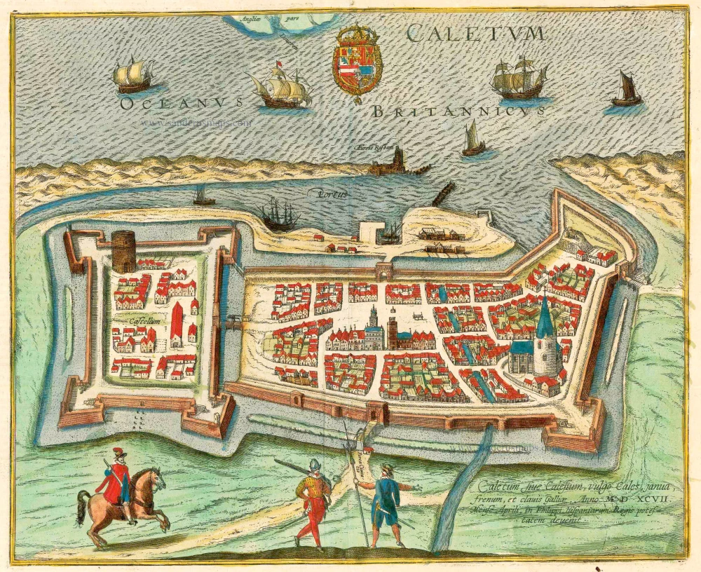
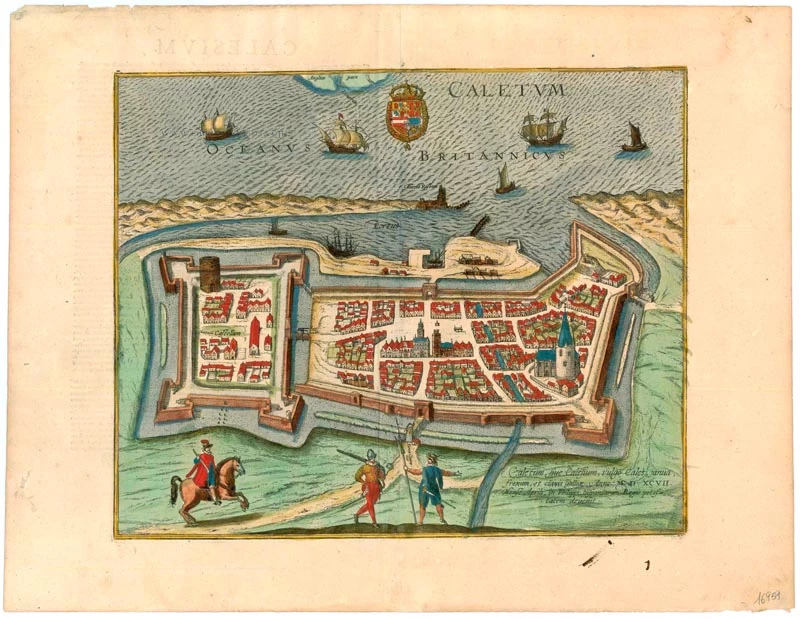

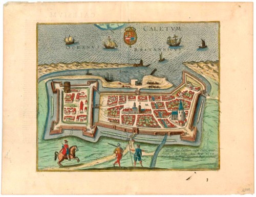

TRANSLATION OF CAPTION: Caletum or Calesium, in French Calais, was a gate of entry, fortress, and key of France that came under the power of Spanish King Philip in April 1597.
COMMENTARY BY BRAUN: "Calais [...] is a city in Flanders, a powerful fortress due to its natural location and the skill of its builders, that has always been considered a key or, as it were, a gateway to France. [...] Calais lies on the border when one travels from Flanders to England, opposite the English port of Dover."
This bird's-eye view shows the city of Calais from the south. Bitterly contested in the Middle Ages, Calais was England's last bastion on the European continent when - after just 200 years in English hands - it was restored to France in 1558. Since the city also suffered severe bombing in the Second World War, little remains today of the historical fabric that is here clearly visible. On the left is the citadel of Calais, built on the foundations of the medieval castle of Philippe Hurepel, Count of Boulogne. The town hall in the city's centre, which was completely remodelled in the Flemish Renaissance style in 1911 and in front of Auguste Rodin's famous monument, The Burghers of Calais, now stands. Also visible on the left is the Tour de Guet, a 13th-century donjon that survives of a former castle, and, on the far right, the church of Notre Dame. (Taschen)
Braun G. & Hogenberg F. and the Civitates Orbis Terrarum.
The Civitates Orbis Terrarum, also known as the 'Braun & Hogenberg', is a six-volume town atlas and the most excellent book of town views and plans ever published: 363 engravings, sometimes beautifully coloured. It was one of the best-selling works in the last quarter of the 16th century. Georg Braun, a skilled writer, wrote the text accompanying the plans and views on the verso. Many plates were engraved after the original drawings of a professional artist, Joris Hoefnagel (1542-1600). The first volume was published in Latin in 1572 and the sixth in 1617. Frans Hogenberg, a talented engraver, created the tables for volumes I through IV, and Simon van den Neuwel made those for volumes V and VI. Other contributors were cartographers Daniel Freese and Heinrich Rantzau, who provided valuable geographical information. Works by Jacob van Deventer, Sebastian Münster, and Johannes Stumpf were also used as references. Translations appeared in German and French, making the atlas accessible to a wider audience.
Since its original publication of volume 1 in 1572, the Civitates Orbis Terrarum has left an indelible mark on the history of cartography. The first volume was followed by seven more editions in 1575, 1577, 1582, 1588, 1593, 1599, and 1612. Vol.2, initially released in 1575, saw subsequent editions in 1597 and 1612. The subsequent volumes, each a treasure trove of historical insights, graced the world in 1581, 1588, 1593, 1599, and 1606. The German translation of the first volume, a testament to its widespread appeal, debuted in 1574, followed by the French edition in 1575.
Several printers were involved: Theodor Graminaeus, Heinrich von Aich, Gottfried von Kempen, Johannis Sinniger, Bertram Buchholtz, and Peter von Brachel, all of whom worked in Cologne.
Georg Braun (1541-1622)
Georg Braun, the author of the text accompanying the plans and views in the Civitates Orbis Terrarum, was born in Cologne in 1541. After his studies in Cologne, he entered the Jesuit Order as a novice, indicating his commitment to learning and intellectual pursuits. In 1561, he obtained his bachelor's degree; in 1562, he received his Magister Artium, further demonstrating his academic achievements. Although he left the Jesuit Order, he continued his studies in theology, gaining a licentiate in theology. His theological background likely influenced the content and tone of the text in the Civitates Orbis Terrarum, adding a unique perspective to the work.
Frans Hogenberg (1535-1590)
Frans Hogenberg was a Flemish and German painter, engraver, and mapmaker. He was born in Mechelen as the son of Nicolaas Hogenberg.
By the end of the 1560s, Frans Hogenberg was employed upon Abraham Ortelius's Theatrum Orbis Terrarum, published in 1570; he is named an engraver of numerous maps. In 1568, he was banned from Antwerp by the Duke of Alva and travelled to London, where he stayed a few years before emigrating to Cologne. He immediately embarked on his two most important works, the Civitates, published in 1572 and the Geschichtsblätter, which appeared in several series from 1569 until about 1587.
Thanks to large-scale projects like the Geschichtsblätter and the Civitates, Hogenberg's social circumstances improved with each passing year. He died as a wealthy man in Cologne in 1590.
Caletum, sive Calesium, vulgo Cales, ...
Item Number: 16959 Authenticity Guarantee
Category: Antique maps > Europe > France - Cities
Old antique plan of Calais by Braun & Hogenberg.
Title: Caletum, sive Calesium, vulgo Cales, ...
Date of the first edition: 1596.
Date of this map: 1596.
Copper engraving, printed on paper.
Size (not including margins): 320 x 390mm (12.6 x 15.35 inches).
Verso: Latin text.
Condition: Excellent, superb old colour.
Condition Rating: A+.
From: Urbium Praecipuarum Mundi Theatrum Quintum Auctore Georgio Braunio Agrippinate. Part 5. Köln, 1596/97. (Van der Krogt 4, 41:1.5)
TRANSLATION OF CAPTION: Caletum or Calesium, in French Calais, was a gate of entry, fortress, and key of France that came under the power of Spanish King Philip in April 1597.
COMMENTARY BY BRAUN: "Calais [...] is a city in Flanders, a powerful fortress due to its natural location and the skill of its builders, that has always been considered a key or, as it were, a gateway to France. [...] Calais lies on the border when one travels from Flanders to England, opposite the English port of Dover."
This bird's-eye view shows the city of Calais from the south. Bitterly contested in the Middle Ages, Calais was England's last bastion on the European continent when - after just 200 years in English hands - it was restored to France in 1558. Since the city also suffered severe bombing in the Second World War, little remains today of the historical fabric that is here clearly visible. On the left is the citadel of Calais, built on the foundations of the medieval castle of Philippe Hurepel, Count of Boulogne. The town hall in the city's centre, which was completely remodelled in the Flemish Renaissance style in 1911 and in front of Auguste Rodin's famous monument, The Burghers of Calais, now stands. Also visible on the left is the Tour de Guet, a 13th-century donjon that survives of a former castle, and, on the far right, the church of Notre Dame. (Taschen)
Braun G. & Hogenberg F. and the Civitates Orbis Terrarum.
The Civitates Orbis Terrarum, also known as the 'Braun & Hogenberg', is a six-volume town atlas and the most excellent book of town views and plans ever published: 363 engravings, sometimes beautifully coloured. It was one of the best-selling works in the last quarter of the 16th century. Georg Braun, a skilled writer, wrote the text accompanying the plans and views on the verso. Many plates were engraved after the original drawings of a professional artist, Joris Hoefnagel (1542-1600). The first volume was published in Latin in 1572 and the sixth in 1617. Frans Hogenberg, a talented engraver, created the tables for volumes I through IV, and Simon van den Neuwel made those for volumes V and VI. Other contributors were cartographers Daniel Freese and Heinrich Rantzau, who provided valuable geographical information. Works by Jacob van Deventer, Sebastian Münster, and Johannes Stumpf were also used as references. Translations appeared in German and French, making the atlas accessible to a wider audience.
Since its original publication of volume 1 in 1572, the Civitates Orbis Terrarum has left an indelible mark on the history of cartography. The first volume was followed by seven more editions in 1575, 1577, 1582, 1588, 1593, 1599, and 1612. Vol.2, initially released in 1575, saw subsequent editions in 1597 and 1612. The subsequent volumes, each a treasure trove of historical insights, graced the world in 1581, 1588, 1593, 1599, and 1606. The German translation of the first volume, a testament to its widespread appeal, debuted in 1574, followed by the French edition in 1575.
Several printers were involved: Theodor Graminaeus, Heinrich von Aich, Gottfried von Kempen, Johannis Sinniger, Bertram Buchholtz, and Peter von Brachel, all of whom worked in Cologne.
Georg Braun (1541-1622)
Georg Braun, the author of the text accompanying the plans and views in the Civitates Orbis Terrarum, was born in Cologne in 1541. After his studies in Cologne, he entered the Jesuit Order as a novice, indicating his commitment to learning and intellectual pursuits. In 1561, he obtained his bachelor's degree; in 1562, he received his Magister Artium, further demonstrating his academic achievements. Although he left the Jesuit Order, he continued his studies in theology, gaining a licentiate in theology. His theological background likely influenced the content and tone of the text in the Civitates Orbis Terrarum, adding a unique perspective to the work.
Frans Hogenberg (1535-1590)
Frans Hogenberg was a Flemish and German painter, engraver, and mapmaker. He was born in Mechelen as the son of Nicolaas Hogenberg.
By the end of the 1560s, Frans Hogenberg was employed upon Abraham Ortelius's Theatrum Orbis Terrarum, published in 1570; he is named an engraver of numerous maps. In 1568, he was banned from Antwerp by the Duke of Alva and travelled to London, where he stayed a few years before emigrating to Cologne. He immediately embarked on his two most important works, the Civitates, published in 1572 and the Geschichtsblätter, which appeared in several series from 1569 until about 1587.
Thanks to large-scale projects like the Geschichtsblätter and the Civitates, Hogenberg's social circumstances improved with each passing year. He died as a wealthy man in Cologne in 1590.
Related items
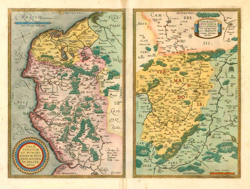
Caletensium et Bononiensium ditionis acurata delineatio. [on sheet with:] Veromanduorum eorumque confinium Exactissima Descript. 1601
Calais & Vermandois, by Abraham Ortelius.
[Item number: 5754]
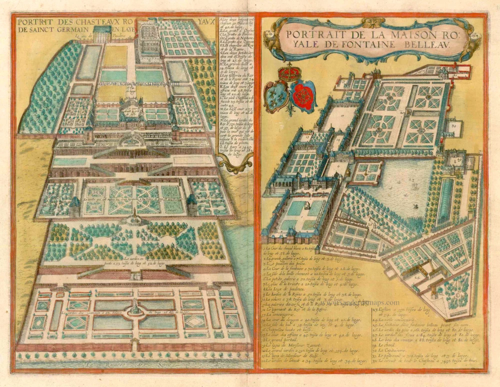
Portrait des Chasteaux Royaux de Sainct Germain en Laye [on sheet with] Portrait de la Maison Royale de Fontaine Belleau. c. 1625
Saint-Germain-en-Laye and Fontainebleau, by Georg Braun and Frans Hogenberg.
[Item number: 16387]
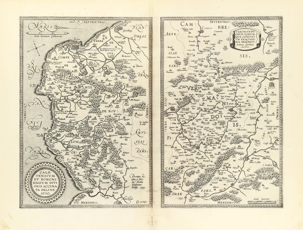
Caletensium et Bononiensium ditionis acurata delineatio. [on sheet with:] Veromanduorum eorumque confinium Exactissima Descript. 1603
Calais & Vermandois by Abraham Ortelius.
[Item number: 22884]
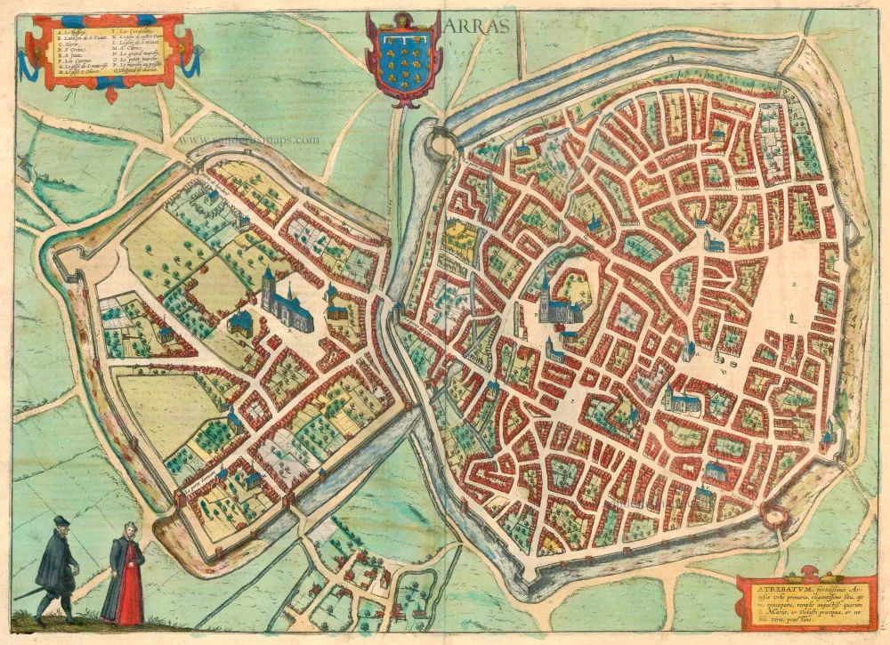
Arras - Atrebatum, fertilissimae Artesiae Urbs primaria, elegantissimo situ, . . . 1599
Arras, by Braun & Hogenberg.
[Item number: 23345]