
Plön, by Georg Braun and Frans Hogenberg. c. 1610

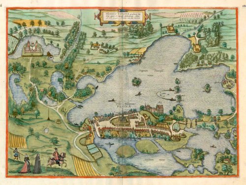
TRANSLATION OF CARTOUCHE TEXT: Drawn on the instructions and at the expense of Heinrich Rantzau, lord of the Lower Elbe, in 1593, when he was 68.
COMMENTARY BY BRAUN: "The Greater Lake, which borders the town and the castle to the south, is two miles long and one mile wide; it is full of fish and the eels exceed the other fish in size and volume; they are caught in five eel crates, one of which belongs to Heinrich Rantzau, the Governor of Denmark, who first tore it down and then rebuilt it from the ground up in a magnificent manner."
Plön is shown in a sweeping bird's-eye view of the countryside surrounding the Greater and Lesser Lake Plön, where many fishermen are seen at work. The palace of Heinrich Rantzau can be seen top left, while Plön castle lies directly above the town. A fortified complex was already established on Olsborg Island in Lake Plön by the 10th century; it was destroyed in 1158 and rebuilt in 1173 beside the small settlement of Plön. In the 12th century, Plön grew into a market town and, in 1236, received its charter. From 1636 to 1761, Plön was the official residence of the Duchy of Schleswig-Holstein-Sonderburg-Plön. (Taschen)
Braun G. & Hogenberg F. and the Civitates Orbis Terrarum.
The Civitates Orbis Terrarum, also known as the 'Braun & Hogenberg', is a six-volume town atlas and the most excellent book of town views and plans ever published: 363 engravings, sometimes beautifully coloured. It was one of the best-selling works in the last quarter of the 16th century. Georg Braun, a skilled writer, wrote the text accompanying the plans and views on the verso. Many plates were engraved after the original drawings of a professional artist, Joris Hoefnagel (1542-1600). The first volume was published in Latin in 1572 and the sixth in 1617. Frans Hogenberg, a talented engraver, created the tables for volumes I through IV, and Simon van den Neuwel made those for volumes V and VI. Other contributors were cartographers Daniel Freese and Heinrich Rantzau, who provided valuable geographical information. Works by Jacob van Deventer, Sebastian Münster, and Johannes Stumpf were also used as references. Translations appeared in German and French, making the atlas accessible to a broader audience.
Since its original publication of volume 1 in 1572, the Civitates Orbis Terrarum has left an indelible mark on the history of cartography. Seven more editions followed the first volume in 1575, 1577, 1582, 1588, 1593, 1599, and 1612. Vol.2, initially released in 1575, saw subsequent editions in 1597 and 1612. The subsequent volumes, each a treasure trove of historical insights, graced the world in 1581, 1588, 1593, 1599, and 1606. The German translation of the first volume, a testament to its widespread appeal, debuted in 1574, followed by the French edition in 1575.
Several printers were involved: Theodor Graminaeus, Heinrich von Aich, Gottfried von Kempen, Johannis Sinniger, Bertram Buchholtz, and Peter von Brachel, all of whom worked in Cologne.
Georg Braun (1541-1622)
Georg Braun, the author of the text accompanying the plans and views in the Civitates Orbis Terrarum, was born in Cologne in 1541. After his studies in Cologne, he entered the Jesuit Order as a novice, indicating his commitment to learning and intellectual pursuits. In 1561, he obtained his bachelor's degree; in 1562, he received his Magister Artium, further demonstrating his academic achievements. Although he left the Jesuit Order, he continued his studies in theology, gaining a licentiate in theology. His theological background likely influenced the content and tone of the text in the Civitates Orbis Terrarum, adding a unique perspective to the work.
Frans Hogenberg (1535-1590)
Frans Hogenberg was a Flemish and German painter, engraver, and mapmaker. He was born in Mechelen as the son of Nicolaas Hogenberg.
By the end of the 1560s, Frans Hogenberg was employed upon Abraham Ortelius's Theatrum Orbis Terrarum, published in 1570; he is named an engraver of numerous maps. In 1568, he was banned from Antwerp by the Duke of Alva and travelled to London, where he stayed a few years before emigrating to Cologne. He immediately embarked on his two most important works, the Civitates, published in 1572 and the Geschichtsblätter, which appeared in several series from 1569 until about 1587.
Thanks to large-scale projects like the Geschichtsblätter and the Civitates, Hogenberg's social circumstances improved with each passing year. He died as a wealthy man in Cologne in 1590.
Urbs Holsatiae Plona.
Item Number: 16701 Authenticity Guarantee
Category: Antique maps > Europe > Germany - Cities
Old, antique bird’s-eye view plan of Plön, by Georg Braun and Frans Hogenberg.
Title: Urbs Holsatiae Plona.
Date of the first edition: 1596.
Date of this map: c. 1610.
Copper engraving, printed on paper.
Size (not including margins): 360 x 495mm (14.17 x 19.49 inches).
Verso: French text.
Condition: Originallcoloured, excellent.
Condition Rating: A+.
From: Théâtre des Principales Villes de tout l'Univers. Tome 5. c. 1610.
TRANSLATION OF CARTOUCHE TEXT: Drawn on the instructions and at the expense of Heinrich Rantzau, lord of the Lower Elbe, in 1593, when he was 68.
COMMENTARY BY BRAUN: "The Greater Lake, which borders the town and the castle to the south, is two miles long and one mile wide; it is full of fish and the eels exceed the other fish in size and volume; they are caught in five eel crates, one of which belongs to Heinrich Rantzau, the Governor of Denmark, who first tore it down and then rebuilt it from the ground up in a magnificent manner."
Plön is shown in a sweeping bird's-eye view of the countryside surrounding the Greater and Lesser Lake Plön, where many fishermen are seen at work. The palace of Heinrich Rantzau can be seen top left, while Plön castle lies directly above the town. A fortified complex was already established on Olsborg Island in Lake Plön by the 10th century; it was destroyed in 1158 and rebuilt in 1173 beside the small settlement of Plön. In the 12th century, Plön grew into a market town and, in 1236, received its charter. From 1636 to 1761, Plön was the official residence of the Duchy of Schleswig-Holstein-Sonderburg-Plön. (Taschen)
Braun G. & Hogenberg F. and the Civitates Orbis Terrarum.
The Civitates Orbis Terrarum, also known as the 'Braun & Hogenberg', is a six-volume town atlas and the most excellent book of town views and plans ever published: 363 engravings, sometimes beautifully coloured. It was one of the best-selling works in the last quarter of the 16th century. Georg Braun, a skilled writer, wrote the text accompanying the plans and views on the verso. Many plates were engraved after the original drawings of a professional artist, Joris Hoefnagel (1542-1600). The first volume was published in Latin in 1572 and the sixth in 1617. Frans Hogenberg, a talented engraver, created the tables for volumes I through IV, and Simon van den Neuwel made those for volumes V and VI. Other contributors were cartographers Daniel Freese and Heinrich Rantzau, who provided valuable geographical information. Works by Jacob van Deventer, Sebastian Münster, and Johannes Stumpf were also used as references. Translations appeared in German and French, making the atlas accessible to a broader audience.
Since its original publication of volume 1 in 1572, the Civitates Orbis Terrarum has left an indelible mark on the history of cartography. Seven more editions followed the first volume in 1575, 1577, 1582, 1588, 1593, 1599, and 1612. Vol.2, initially released in 1575, saw subsequent editions in 1597 and 1612. The subsequent volumes, each a treasure trove of historical insights, graced the world in 1581, 1588, 1593, 1599, and 1606. The German translation of the first volume, a testament to its widespread appeal, debuted in 1574, followed by the French edition in 1575.
Several printers were involved: Theodor Graminaeus, Heinrich von Aich, Gottfried von Kempen, Johannis Sinniger, Bertram Buchholtz, and Peter von Brachel, all of whom worked in Cologne.
Georg Braun (1541-1622)
Georg Braun, the author of the text accompanying the plans and views in the Civitates Orbis Terrarum, was born in Cologne in 1541. After his studies in Cologne, he entered the Jesuit Order as a novice, indicating his commitment to learning and intellectual pursuits. In 1561, he obtained his bachelor's degree; in 1562, he received his Magister Artium, further demonstrating his academic achievements. Although he left the Jesuit Order, he continued his studies in theology, gaining a licentiate in theology. His theological background likely influenced the content and tone of the text in the Civitates Orbis Terrarum, adding a unique perspective to the work.
Frans Hogenberg (1535-1590)
Frans Hogenberg was a Flemish and German painter, engraver, and mapmaker. He was born in Mechelen as the son of Nicolaas Hogenberg.
By the end of the 1560s, Frans Hogenberg was employed upon Abraham Ortelius's Theatrum Orbis Terrarum, published in 1570; he is named an engraver of numerous maps. In 1568, he was banned from Antwerp by the Duke of Alva and travelled to London, where he stayed a few years before emigrating to Cologne. He immediately embarked on his two most important works, the Civitates, published in 1572 and the Geschichtsblätter, which appeared in several series from 1569 until about 1587.
Thanks to large-scale projects like the Geschichtsblätter and the Civitates, Hogenberg's social circumstances improved with each passing year. He died as a wealthy man in Cologne in 1590.
Related items

Marpurg. - Martpurgum Urbs Hassiae Metropolis, Universitate Clara [on sheet with] Cassel. - Cassula, Communiter Cassel, Florentissimu Lanigerae Oppidum 1572-1624
Marburg and Cassel, by Georg Braun and Frans Hogenberg.
[Item number: 17986]

Landshut 1599
Landshut, by Georg Braun and Frans Hogenberg.
[Item number: 24060]