
Rostock by Braun & Hogenberg 1596-1640
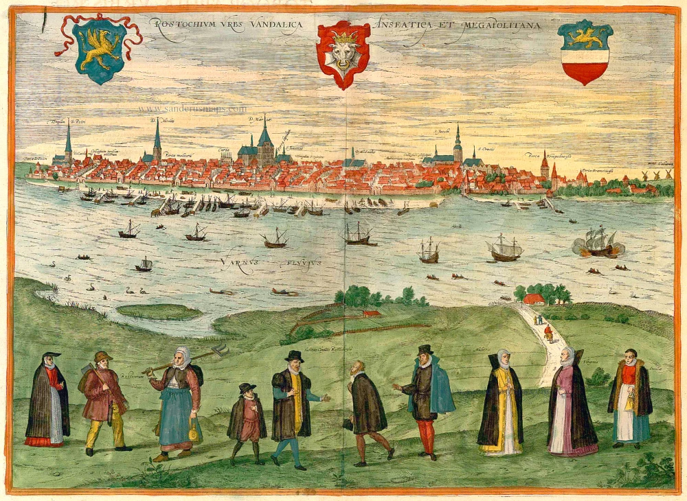
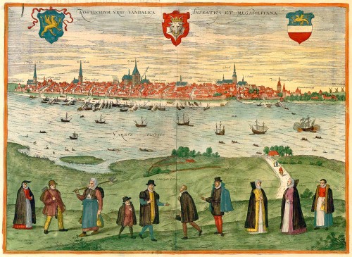


CAPTION: The Mecklenburgish Hanseatic City of Rostock, city of the Vandals.
COMMENTARY BY BRAUN: "Maritime trade is the reason that Rostock has won great regard and influence and a number of citizens have amassed considerable wealth, since some export grain, flour and beer to other parts of Europe, others deal in butter, sheep, dried fish, wood, iron and tin. Rostock beer, of which 25000 barrels are produced each year by 50 brewers, is better than all other Norwegian beers for its quality and taste. That the number seven held a particular significance for the former inhabitants is witnessed by seven remarkable things."
This view of Rostock shows the city, its architecture still heavily indebted to the Gothic style, from across the Warnow River to the north. The present plate is supplemented in the foreground by staffage figures illustrating local costumes, identified from left to right as follows: peasants and councillors from Rostock - burgher - married woman - unmarried woman - maid. Visible on the skyline are a number of important works of brick Gothic architecture: from the left, the churches of St Peter and St Nicholas, the town hall with seven spires, St Mary's church with seven doors and the astronomical clock. Since Braun refers to the number seven, it should be mentioned that Rostock also had seven city gates and seven shipyards. Rostock was a major centre of commerce from the 14th century onwards. Aided by its geographical location, ideal for trade with Scandinavia and the Baltic region, and its natural harbour 15 km from the Baltic Sea, the city was amongst the founding members of the Wendish Hansa. The university, established in 1419, was the first in the Baltic region. At the end of the 16th century Rostock had some 15,000 inhabitants. (Taschen)
Braun G. & Hogenberg F. and the Civitates Orbis Terrarum.
The Civitates Orbis Terrarum, also known as the 'Braun & Hogenberg', is a six-volume town atlas and the most excellent book of town views and plans ever published: 363 engravings, sometimes beautifully coloured. It was one of the best-selling works in the last quarter of the 16th century. Georg Braun, a skilled writer, wrote the text accompanying the plans and views on the verso. Many plates were engraved after the original drawings of a professional artist, Joris Hoefnagel (1542-1600). The first volume was published in Latin in 1572 and the sixth in 1617. Frans Hogenberg, a talented engraver, created the tables for volumes I through IV, and Simon van den Neuwel made those for volumes V and VI. Other contributors were cartographers Daniel Freese and Heinrich Rantzau, who provided valuable geographical information. Works by Jacob van Deventer, Sebastian Münster, and Johannes Stumpf were also used as references. Translations appeared in German and French, making the atlas accessible to a wider audience.
Since its original publication of volume 1 in 1572, the Civitates Orbis Terrarum has left an indelible mark on the history of cartography. The first volume was followed by seven more editions in 1575, 1577, 1582, 1588, 1593, 1599, and 1612. Vol.2, initially released in 1575, saw subsequent editions in 1597 and 1612. The subsequent volumes, each a treasure trove of historical insights, graced the world in 1581, 1588, 1593, 1599, and 1606. The German translation of the first volume, a testament to its widespread appeal, debuted in 1574, followed by the French edition in 1575.
Several printers were involved: Theodor Graminaeus, Heinrich von Aich, Gottfried von Kempen, Johannis Sinniger, Bertram Buchholtz, and Peter von Brachel, all of whom worked in Cologne.
Georg Braun (1541-1622)
Georg Braun, the author of the text accompanying the plans and views in the Civitates Orbis Terrarum, was born in Cologne in 1541. After his studies in Cologne, he entered the Jesuit Order as a novice, indicating his commitment to learning and intellectual pursuits. In 1561, he obtained his bachelor's degree; in 1562, he received his Magister Artium, further demonstrating his academic achievements. Although he left the Jesuit Order, he continued his studies in theology, gaining a licentiate in theology. His theological background likely influenced the content and tone of the text in the Civitates Orbis Terrarum, adding a unique perspective to the work.
Frans Hogenberg (1535-1590)
Frans Hogenberg was a Flemish and German painter, engraver, and mapmaker. He was born in Mechelen as the son of Nicolaas Hogenberg.
By the end of the 1560s, Frans Hogenberg was employed upon Abraham Ortelius's Theatrum Orbis Terrarum, published in 1570; he is named an engraver of numerous maps. In 1568, he was banned from Antwerp by the Duke of Alva and travelled to London, where he stayed a few years before emigrating to Cologne. He immediately embarked on his two most important works, the Civitates, published in 1572 and the Geschichtsblätter, which appeared in several series from 1569 until about 1587.
Thanks to large-scale projects like the Geschichtsblätter and the Civitates, Hogenberg's social circumstances improved with each passing year. He died as a wealthy man in Cologne in 1590.
Rostochium Urbs Vandalica Anseatica et Megapolitana.
Item Number: 22099 Authenticity Guarantee
Category: Antique maps > Europe > Germany - Cities
General view of Rostock by Georg Braun and Frans Hogenberg.
Copper engraving
Size: 36.5 x 49cm (14.2 x 19.1 inches)
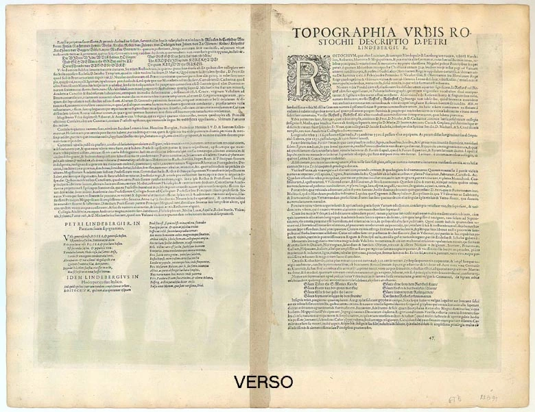
Verso text: Latin
Condition: Old coloured.
Condition Rating: A
References: Taschen, Braun and Hogenberg, p.402.
From: Civitates Orbis Terrarum, ... Part 5. Köln, 1598.
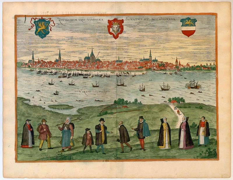
CAPTION: The Mecklenburgish Hanseatic City of Rostock, city of the Vandals.
COMMENTARY BY BRAUN: "Maritime trade is the reason that Rostock has won great regard and influence and a number of citizens have amassed considerable wealth, since some export grain, flour and beer to other parts of Europe, others deal in butter, sheep, dried fish, wood, iron and tin. Rostock beer, of which 25000 barrels are produced each year by 50 brewers, is better than all other Norwegian beers for its quality and taste. That the number seven held a particular significance for the former inhabitants is witnessed by seven remarkable things."
This view of Rostock shows the city, its architecture still heavily indebted to the Gothic style, from across the Warnow River to the north. The present plate is supplemented in the foreground by staffage figures illustrating local costumes, identified from left to right as follows: peasants and councillors from Rostock - burgher - married woman - unmarried woman - maid. Visible on the skyline are a number of important works of brick Gothic architecture: from the left, the churches of St Peter and St Nicholas, the town hall with seven spires, St Mary's church with seven doors and the astronomical clock. Since Braun refers to the number seven, it should be mentioned that Rostock also had seven city gates and seven shipyards. Rostock was a major centre of commerce from the 14th century onwards. Aided by its geographical location, ideal for trade with Scandinavia and the Baltic region, and its natural harbour 15 km from the Baltic Sea, the city was amongst the founding members of the Wendish Hansa. The university, established in 1419, was the first in the Baltic region. At the end of the 16th century Rostock had some 15,000 inhabitants. (Taschen)
Braun G. & Hogenberg F. and the Civitates Orbis Terrarum.
The Civitates Orbis Terrarum, also known as the 'Braun & Hogenberg', is a six-volume town atlas and the most excellent book of town views and plans ever published: 363 engravings, sometimes beautifully coloured. It was one of the best-selling works in the last quarter of the 16th century. Georg Braun, a skilled writer, wrote the text accompanying the plans and views on the verso. Many plates were engraved after the original drawings of a professional artist, Joris Hoefnagel (1542-1600). The first volume was published in Latin in 1572 and the sixth in 1617. Frans Hogenberg, a talented engraver, created the tables for volumes I through IV, and Simon van den Neuwel made those for volumes V and VI. Other contributors were cartographers Daniel Freese and Heinrich Rantzau, who provided valuable geographical information. Works by Jacob van Deventer, Sebastian Münster, and Johannes Stumpf were also used as references. Translations appeared in German and French, making the atlas accessible to a wider audience.
Since its original publication of volume 1 in 1572, the Civitates Orbis Terrarum has left an indelible mark on the history of cartography. The first volume was followed by seven more editions in 1575, 1577, 1582, 1588, 1593, 1599, and 1612. Vol.2, initially released in 1575, saw subsequent editions in 1597 and 1612. The subsequent volumes, each a treasure trove of historical insights, graced the world in 1581, 1588, 1593, 1599, and 1606. The German translation of the first volume, a testament to its widespread appeal, debuted in 1574, followed by the French edition in 1575.
Several printers were involved: Theodor Graminaeus, Heinrich von Aich, Gottfried von Kempen, Johannis Sinniger, Bertram Buchholtz, and Peter von Brachel, all of whom worked in Cologne.
Georg Braun (1541-1622)
Georg Braun, the author of the text accompanying the plans and views in the Civitates Orbis Terrarum, was born in Cologne in 1541. After his studies in Cologne, he entered the Jesuit Order as a novice, indicating his commitment to learning and intellectual pursuits. In 1561, he obtained his bachelor's degree; in 1562, he received his Magister Artium, further demonstrating his academic achievements. Although he left the Jesuit Order, he continued his studies in theology, gaining a licentiate in theology. His theological background likely influenced the content and tone of the text in the Civitates Orbis Terrarum, adding a unique perspective to the work.
Frans Hogenberg (1535-1590)
Frans Hogenberg was a Flemish and German painter, engraver, and mapmaker. He was born in Mechelen as the son of Nicolaas Hogenberg.
By the end of the 1560s, Frans Hogenberg was employed upon Abraham Ortelius's Theatrum Orbis Terrarum, published in 1570; he is named an engraver of numerous maps. In 1568, he was banned from Antwerp by the Duke of Alva and travelled to London, where he stayed a few years before emigrating to Cologne. He immediately embarked on his two most important works, the Civitates, published in 1572 and the Geschichtsblätter, which appeared in several series from 1569 until about 1587.
Thanks to large-scale projects like the Geschichtsblätter and the Civitates, Hogenberg's social circumstances improved with each passing year. He died as a wealthy man in Cologne in 1590.
Related items
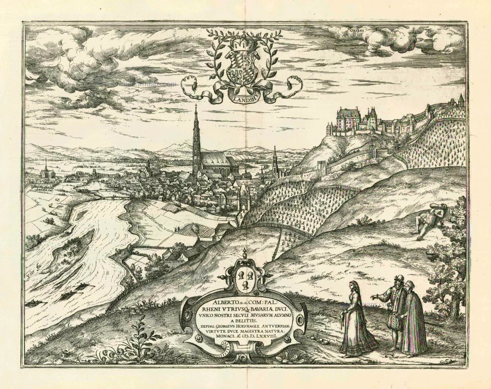
Landshut 1599
Landshut, by Georg Braun and Frans Hogenberg.
[Item number: 24060]
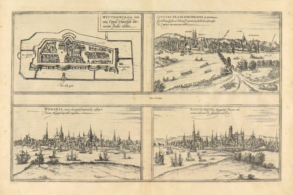
Wittenburga Saxoniae Ippid: Universali litterarum studio celebre. [on sheet with] Civitas Francfordiensis In Marchionatu Brandeburgensi, sita ad Oderam fl: optimorum Gymnasio, & Emporio mercatorum celebris. [and] Wismaria, natura loci populi frequentia, & aedificijs in Ducatu Megapolensj, Nobile Oppidum. [and] Rostochium, Megapolensis Ducatus urbs nominis celebritate, Academia prestans. 1574
Wittenberg - Frankfurt an der Oder - Weimar - Rostock, by Georg Braun & Frans Hogenberg.
[Item number: 28038]