
Munich (München), by Braun and Hogenberg, after Georg Hoefnagel. c. 1593
The item displayed on this page has been sold. However, we have a similar map in stock:
Panoramic view of Munich (München), by Braun and Hogenberg, after Georg Hoefnagel. 1588
Monachium Utriusque Bavariae Civitas Primar.
[Item number: 30926]

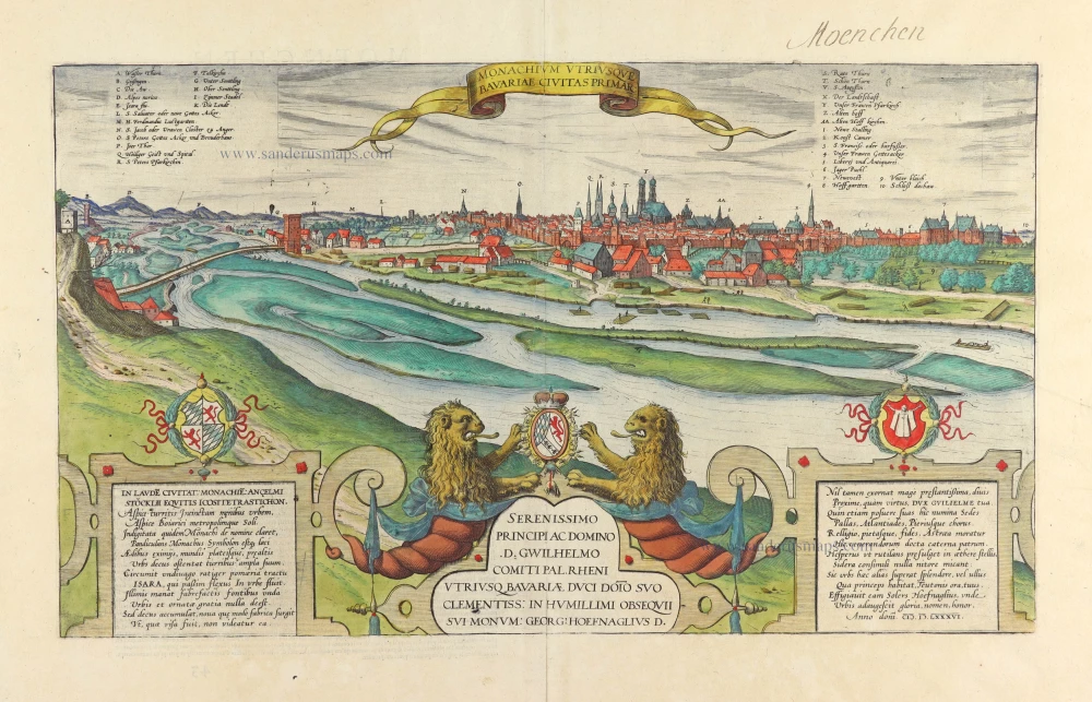


TRANSLATION CARTOUCHE TOP: Munich, capital of the two Bavarias.
CARTOUCHES BOTTOM LEFT AND RIGHT: A poem in 24 verses by the knight Anselmus Stöckli praises the city of Munich.
CARTOUCHE BOTTOM CENTRE: To his most gracious Prince and Lord, D. William, Rhenish Palgrave and Duke of the two Bavarias, his most benevolent Lord as a sign of his humblest gratitude from Georg Hoefnagel.
COMMENTARY BY BRAUN: "When Henry, Duke in Saxony and Bavaria, had returned from the pilgrimage undertaken from piety to Jerusalem [...], he is said to return to his (now known as Upper Bavaria) region and there, near the monastic establishment of the Schefflar chapterhouse, he built a new city, which he called Munich [...]. However, because the accustomed salt and overland route to Salzburg, which even to the present day runs along the Bavarian Alps and is rich in its revenues from salt, at that time ran through Föhring, where there was also a bridge and a trading post, Henry is said to have launched a surprise attack at Föhring, demolishing its bridge and transferring the salt trade along with the bridge toll to the city he had just built."
This plate shows a panoramic view of the city on the Isar and its environs, seen from the east. In the left background, the Alps are visible south of the city (D). The Isar gate (P) stands out amid the city's fortifications. Above the whole tower are the spires of the cathedral of Our Blessed Lady, also known as the Frauenkirche (Y), whose existing structure was begun in 1468. To the right is the Alter Hof with the chapel of St Lawrence. The New Residence was built on the city's northern fringes (7). St Peter's (O) is Munich's oldest parish church. (Taschen)
Braun G. & Hogenberg F. and the Civitates Orbis Terrarum.
The Civitates Orbis Terrarum, also known as the 'Braun & Hogenberg', is a six-volume town atlas and the most excellent book of town views and plans ever published: 363 engravings, sometimes beautifully coloured. It was one of the best-selling works in the last quarter of the 16th century. Georg Braun, a skilled writer, wrote the text accompanying the plans and views on the verso. Many plates were engraved after the original drawings of a professional artist, Joris Hoefnagel (1542-1600). The first volume was published in Latin in 1572 and the sixth in 1617. Frans Hogenberg, a talented engraver, created the tables for volumes I through IV, and Simon van den Neuwel made those for volumes V and VI. Other contributors were cartographers Daniel Freese and Heinrich Rantzau, who provided valuable geographical information. Works by Jacob van Deventer, Sebastian Münster, and Johannes Stumpf were also used as references. Translations appeared in German and French, making the atlas accessible to a wider audience.
Since its original publication of volume 1 in 1572, the Civitates Orbis Terrarum has left an indelible mark on the history of cartography. The first volume was followed by seven more editions in 1575, 1577, 1582, 1588, 1593, 1599, and 1612. Vol.2, initially released in 1575, saw subsequent editions in 1597 and 1612. The subsequent volumes, each a treasure trove of historical insights, graced the world in 1581, 1588, 1593, 1599, and 1606. The German translation of the first volume, a testament to its widespread appeal, debuted in 1574, followed by the French edition in 1575.
Several printers were involved: Theodor Graminaeus, Heinrich von Aich, Gottfried von Kempen, Johannis Sinniger, Bertram Buchholtz, and Peter von Brachel, all of whom worked in Cologne.
Georg Braun (1541-1622)
Georg Braun, the author of the text accompanying the plans and views in the Civitates Orbis Terrarum, was born in Cologne in 1541. After his studies in Cologne, he entered the Jesuit Order as a novice, indicating his commitment to learning and intellectual pursuits. In 1561, he obtained his bachelor's degree; in 1562, he received his Magister Artium, further demonstrating his academic achievements. Although he left the Jesuit Order, he continued his studies in theology, gaining a licentiate in theology. His theological background likely influenced the content and tone of the text in the Civitates Orbis Terrarum, adding a unique perspective to the work.
Frans Hogenberg (1535-1590)
Frans Hogenberg was a Flemish and German painter, engraver, and mapmaker. He was born in Mechelen as the son of Nicolaas Hogenberg.
By the end of the 1560s, Frans Hogenberg was employed upon Abraham Ortelius's Theatrum Orbis Terrarum, published in 1570; he is named an engraver of numerous maps. In 1568, he was banned from Antwerp by the Duke of Alva and travelled to London, where he stayed a few years before emigrating to Cologne. He immediately embarked on his two most important works, the Civitates, published in 1572 and the Geschichtsblätter, which appeared in several series from 1569 until about 1587.
Thanks to large-scale projects like the Geschichtsblätter and the Civitates, Hogenberg's social circumstances improved with each passing year. He died as a wealthy man in Cologne in 1590.
Monachium Utriusque Bavariae Civitas Primar.
Item Number: 30617 Authenticity Guarantee
Category: Antique maps > Europe > Germany - Cities
Panoramic view of Munich (München), by Braun and Hogenberg, after Georg Hoefnagel.
Title: Monachium Utriusque Bavariae Civitas Primar.
With a dedication by Georg Hoefnagel.
Latin poem by Ancelmus Stöcklius, dated M.D.LXXXVI. (1586).
Cartographer: Georg Hoefnagel.
Date of the first edition: 1588.
Date of this map: c. 1593.
Date on map: 1586.
Copper engraving, printed on paper.
Image size: 285 x 485mm (11.22 x 19.09 inches).
Sheet size: 410 x 540mm (16.14 x 21.26 inches).
Verso: French text.
Condition: Original coloured, excellent.
Condition Rating: A+.
From: Liber Quartus - Livre Quatriesme des Principales Villes du Monde, 1593. (Van der Krogt 4, 41:3.4(1593))
TRANSLATION CARTOUCHE TOP: Munich, capital of the two Bavarias.
CARTOUCHES BOTTOM LEFT AND RIGHT: A poem in 24 verses by the knight Anselmus Stöckli praises the city of Munich.
CARTOUCHE BOTTOM CENTRE: To his most gracious Prince and Lord, D. William, Rhenish Palgrave and Duke of the two Bavarias, his most benevolent Lord as a sign of his humblest gratitude from Georg Hoefnagel.
COMMENTARY BY BRAUN: "When Henry, Duke in Saxony and Bavaria, had returned from the pilgrimage undertaken from piety to Jerusalem [...], he is said to return to his (now known as Upper Bavaria) region and there, near the monastic establishment of the Schefflar chapterhouse, he built a new city, which he called Munich [...]. However, because the accustomed salt and overland route to Salzburg, which even to the present day runs along the Bavarian Alps and is rich in its revenues from salt, at that time ran through Föhring, where there was also a bridge and a trading post, Henry is said to have launched a surprise attack at Föhring, demolishing its bridge and transferring the salt trade along with the bridge toll to the city he had just built."
This plate shows a panoramic view of the city on the Isar and its environs, seen from the east. In the left background, the Alps are visible south of the city (D). The Isar gate (P) stands out amid the city's fortifications. Above the whole tower are the spires of the cathedral of Our Blessed Lady, also known as the Frauenkirche (Y), whose existing structure was begun in 1468. To the right is the Alter Hof with the chapel of St Lawrence. The New Residence was built on the city's northern fringes (7). St Peter's (O) is Munich's oldest parish church. (Taschen)
Braun G. & Hogenberg F. and the Civitates Orbis Terrarum.
The Civitates Orbis Terrarum, also known as the 'Braun & Hogenberg', is a six-volume town atlas and the most excellent book of town views and plans ever published: 363 engravings, sometimes beautifully coloured. It was one of the best-selling works in the last quarter of the 16th century. Georg Braun, a skilled writer, wrote the text accompanying the plans and views on the verso. Many plates were engraved after the original drawings of a professional artist, Joris Hoefnagel (1542-1600). The first volume was published in Latin in 1572 and the sixth in 1617. Frans Hogenberg, a talented engraver, created the tables for volumes I through IV, and Simon van den Neuwel made those for volumes V and VI. Other contributors were cartographers Daniel Freese and Heinrich Rantzau, who provided valuable geographical information. Works by Jacob van Deventer, Sebastian Münster, and Johannes Stumpf were also used as references. Translations appeared in German and French, making the atlas accessible to a wider audience.
Since its original publication of volume 1 in 1572, the Civitates Orbis Terrarum has left an indelible mark on the history of cartography. The first volume was followed by seven more editions in 1575, 1577, 1582, 1588, 1593, 1599, and 1612. Vol.2, initially released in 1575, saw subsequent editions in 1597 and 1612. The subsequent volumes, each a treasure trove of historical insights, graced the world in 1581, 1588, 1593, 1599, and 1606. The German translation of the first volume, a testament to its widespread appeal, debuted in 1574, followed by the French edition in 1575.
Several printers were involved: Theodor Graminaeus, Heinrich von Aich, Gottfried von Kempen, Johannis Sinniger, Bertram Buchholtz, and Peter von Brachel, all of whom worked in Cologne.
Georg Braun (1541-1622)
Georg Braun, the author of the text accompanying the plans and views in the Civitates Orbis Terrarum, was born in Cologne in 1541. After his studies in Cologne, he entered the Jesuit Order as a novice, indicating his commitment to learning and intellectual pursuits. In 1561, he obtained his bachelor's degree; in 1562, he received his Magister Artium, further demonstrating his academic achievements. Although he left the Jesuit Order, he continued his studies in theology, gaining a licentiate in theology. His theological background likely influenced the content and tone of the text in the Civitates Orbis Terrarum, adding a unique perspective to the work.
Frans Hogenberg (1535-1590)
Frans Hogenberg was a Flemish and German painter, engraver, and mapmaker. He was born in Mechelen as the son of Nicolaas Hogenberg.
By the end of the 1560s, Frans Hogenberg was employed upon Abraham Ortelius's Theatrum Orbis Terrarum, published in 1570; he is named an engraver of numerous maps. In 1568, he was banned from Antwerp by the Duke of Alva and travelled to London, where he stayed a few years before emigrating to Cologne. He immediately embarked on his two most important works, the Civitates, published in 1572 and the Geschichtsblätter, which appeared in several series from 1569 until about 1587.
Thanks to large-scale projects like the Geschichtsblätter and the Civitates, Hogenberg's social circumstances improved with each passing year. He died as a wealthy man in Cologne in 1590.
Related items
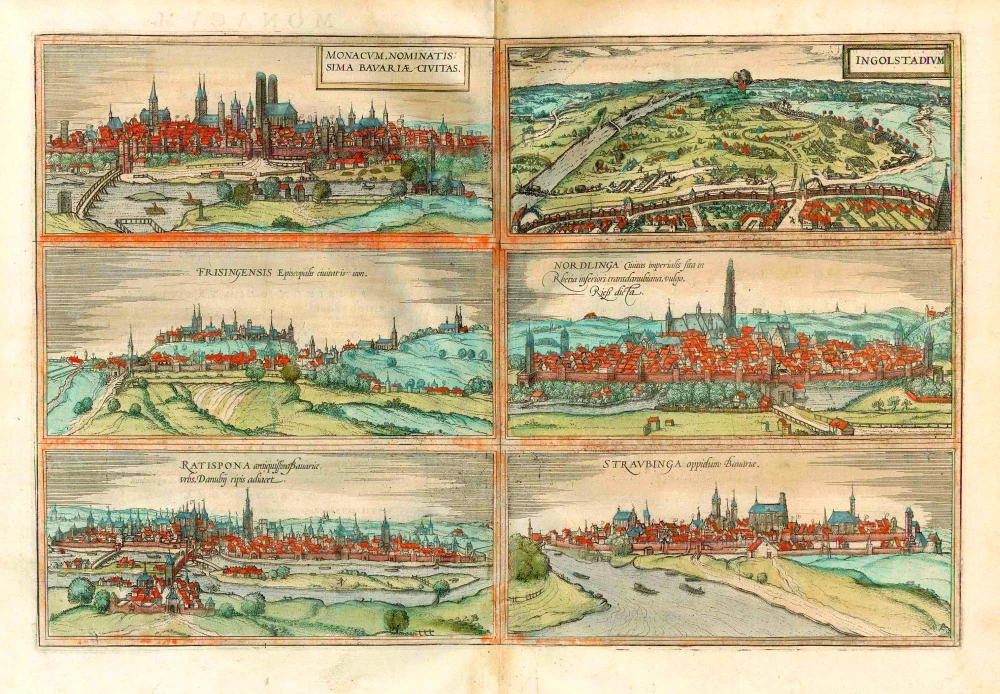
Monacum, nominatis sima Bavariae, Civitas [on sheet with] Ingolstadium [and] Frisingensis ... [and] Nordlinga ... [and] Ratispona ... [and] Straubinga ...
1577
München, Ingolstadt, Freissing, Nördlingen, Regensburg and Straubing, by Georg Braun and Frans Hogenberg.
[Item number: 26679]
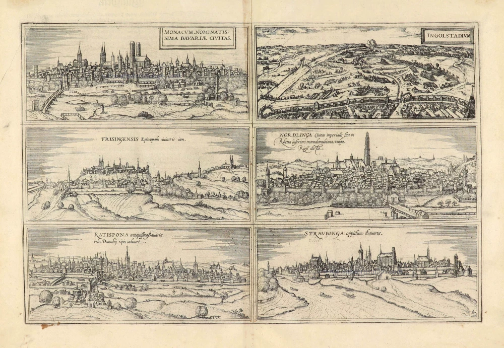
Monacum, nominatis sima Bavariae, Civitas. [on sheet with] Ingolstadium. [and] Frisingensis Episcopalis civitatis icon. [and] Nordlinga Civitas imperialis sita in Rhetia inferioris transdanubiana, vulgo Rieß dicta. [and] Ratispona antiquissima Bavariae urbs, Danubij ripis adiacet. [and] Straubinga oppidum Bavariae. 1574
München, Ingolstadt, Freising, Nördlingen, Regensburg and Straubing, by Georg Braun & Frans Hogenberg.
[Item number: 28041]