
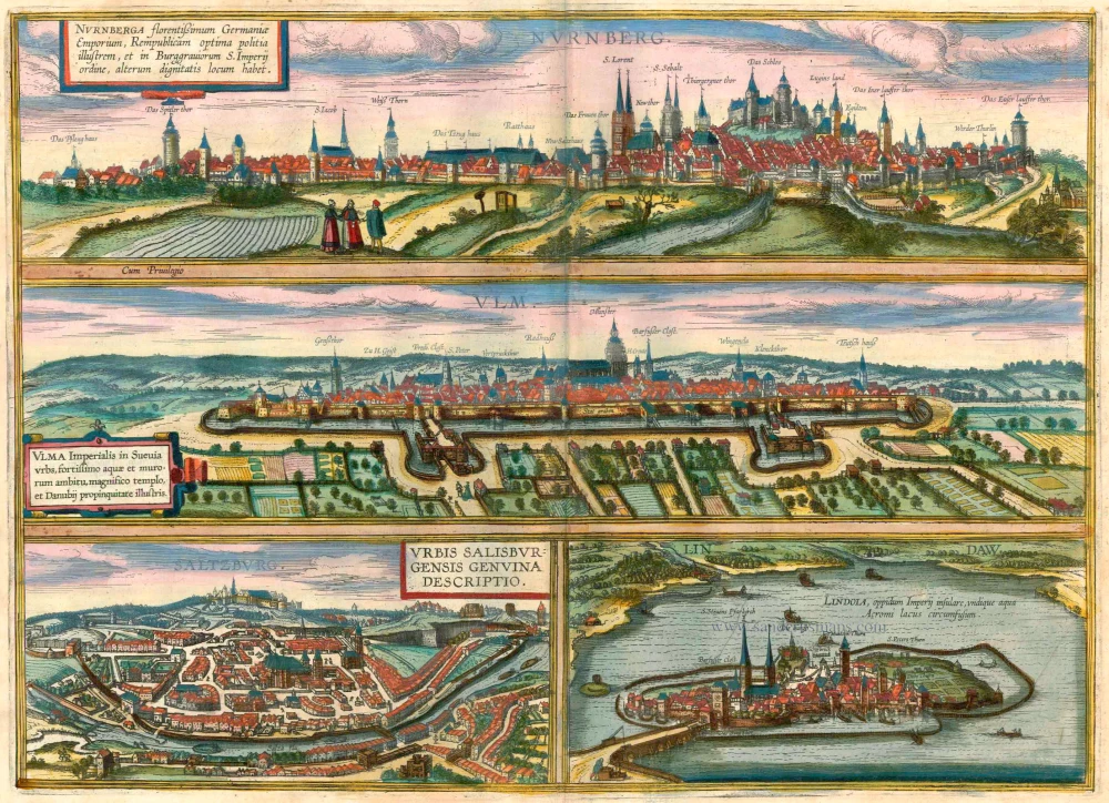
Nürnberg, by Georg Braun and Frans Hogenberg. 1593

TRANSLATION OF CARTOUCHE TEXT: The well-known city of Nuremberg is effectively the centre of all Germany and is distinguished by public and private buildings, very rich merchants and a wise council; it has skilled master craftsmen of all kinds, is fortified by strong city walls, castles and moats of sufficient width and depth. The lover of the fine arts D. Cornelius Chaymox, a Nuremberg merchant, has very kindly supported our topographical project with this plate. COMMENTARY BY BRAUN (on the verso): "The Altmühl flows through Eichstätt towards Kehlheim into the Danube, the Pegnitz flows in the north towards Schwabach and joins the Main at Bamberg. Emperor Charles therefore began construction work, ordering many thousand men to take part, and had a channel dug between these two rivers, which was over 2,000 paces long and 300 feet wide, but the work was in vain, for it rained very much at the time and the ground at that place was marshy, so that the work was not completed." In neither view of Nuremberg does the castle above the city dominate the city, for the hills have been flattened out, especially in this view. Yet one can clearly make out the well-fortified city wall, the mighty castle and the main churches of SS Lawrence and Sebald, as landmarks of the two original parts of the city. The imposing city towers, the Arsenal, the Salt House and the monastery of St Giles are visually emphasized. The present plate is dominated by the figures of patricians in local dress. The two elegantly dressed children to the right of the cartouche are striking, for there are no comparable cases of children as staffage figures. In the 16th century, although Nuremberg had no university, the city was a centre of book printing (Anton Koberger), of art (Michael Wolgemut, Albrecht Dürer, Adam Krafft, Veit Stoss), of literature (Hans Sachs), of geography (Martin Behaim), of educated patrician families (including Pirckheimer, Löffelholz) and of trade. In addition to Augsburg, Nuremberg was the most influential trade city in central Europe. (Taschen)
Braun G. & Hogenberg F. and the Civitates Orbis Terrarum.
The Civitates Orbis Terrarum, also known as the 'Braun & Hogenberg', is a six-volume town atlas and the most excellent book of town views and plans ever published: 363 engravings, sometimes beautifully coloured. It was one of the best-selling works in the last quarter of the 16th century. Georg Braun, a skilled writer, wrote the text accompanying the plans and views on the verso. Many plates were engraved after the original drawings of a professional artist, Joris Hoefnagel (1542-1600). The first volume was published in Latin in 1572 and the sixth in 1617. Frans Hogenberg, a talented engraver, created the tables for volumes I through IV, and Simon van den Neuwel made those for volumes V and VI. Other contributors were cartographers Daniel Freese and Heinrich Rantzau, who provided valuable geographical information. Works by Jacob van Deventer, Sebastian Münster, and Johannes Stumpf were also used as references. Translations appeared in German and French, making the atlas accessible to a broader audience.
Since its original publication of volume 1 in 1572, the Civitates Orbis Terrarum has left an indelible mark on the history of cartography. Seven more editions followed the first volume in 1575, 1577, 1582, 1588, 1593, 1599, and 1612. Vol.2, initially released in 1575, saw subsequent editions in 1597 and 1612. The subsequent volumes, each a treasure trove of historical insights, graced the world in 1581, 1588, 1593, 1599, and 1606. The German translation of the first volume, a testament to its widespread appeal, debuted in 1574, followed by the French edition in 1575.
Several printers were involved: Theodor Graminaeus, Heinrich von Aich, Gottfried von Kempen, Johannis Sinniger, Bertram Buchholtz, and Peter von Brachel, all of whom worked in Cologne.
Georg Braun (1541-1622)
Georg Braun, the author of the text accompanying the plans and views in the Civitates Orbis Terrarum, was born in Cologne in 1541. After his studies in Cologne, he entered the Jesuit Order as a novice, indicating his commitment to learning and intellectual pursuits. In 1561, he obtained his bachelor's degree; in 1562, he received his Magister Artium, further demonstrating his academic achievements. Although he left the Jesuit Order, he continued his studies in theology, gaining a licentiate in theology. His theological background likely influenced the content and tone of the text in the Civitates Orbis Terrarum, adding a unique perspective to the work.
Frans Hogenberg (1535-1590)
Frans Hogenberg was a Flemish and German painter, engraver, and mapmaker. He was born in Mechelen as the son of Nicolaas Hogenberg.
By the end of the 1560s, Frans Hogenberg was employed upon Abraham Ortelius's Theatrum Orbis Terrarum, published in 1570; he is named an engraver of numerous maps. In 1568, he was banned from Antwerp by the Duke of Alva and travelled to London, where he stayed a few years before emigrating to Cologne. He immediately embarked on his two most important works, the Civitates, published in 1572 and the Geschichtsblätter, which appeared in several series from 1569 until about 1587.
Thanks to large-scale projects like the Geschichtsblätter and the Civitates, Hogenberg's social circumstances improved with each passing year. He died as a wealthy man in Cologne in 1590.
Nurnberg - Norenberga, Urbs nobilissima, . . .
Item Number: 27634 Authenticity Guarantee
Category: Antique maps > Europe > Germany - Cities
Old, antique map - panoramic view of Nürnberg, by Georg Braun and Frans Hogenberg.
Date of the first edition: 1575
Date of this map: 1593
Copper engraving, printed on paper.
Size (not including margins): 34 x 49cm (13.3 x 19.1 inches)
Verso text: French
Condition: Original coloured, excellent.
Condition Rating: A
References: Van der Krogt 4, #3127; Fauser, #10035; Taschen, Br. and Hog., p.174.
TRANSLATION OF CARTOUCHE TEXT: The well-known city of Nuremberg is effectively the centre of all Germany and is distinguished by public and private buildings, very rich merchants and a wise council; it has skilled master craftsmen of all kinds, is fortified by strong city walls, castles and moats of sufficient width and depth. The lover of the fine arts D. Cornelius Chaymox, a Nuremberg merchant, has very kindly supported our topographical project with this plate. COMMENTARY BY BRAUN (on the verso): "The Altmühl flows through Eichstätt towards Kehlheim into the Danube, the Pegnitz flows in the north towards Schwabach and joins the Main at Bamberg. Emperor Charles therefore began construction work, ordering many thousand men to take part, and had a channel dug between these two rivers, which was over 2,000 paces long and 300 feet wide, but the work was in vain, for it rained very much at the time and the ground at that place was marshy, so that the work was not completed." In neither view of Nuremberg does the castle above the city dominate the city, for the hills have been flattened out, especially in this view. Yet one can clearly make out the well-fortified city wall, the mighty castle and the main churches of SS Lawrence and Sebald, as landmarks of the two original parts of the city. The imposing city towers, the Arsenal, the Salt House and the monastery of St Giles are visually emphasized. The present plate is dominated by the figures of patricians in local dress. The two elegantly dressed children to the right of the cartouche are striking, for there are no comparable cases of children as staffage figures. In the 16th century, although Nuremberg had no university, the city was a centre of book printing (Anton Koberger), of art (Michael Wolgemut, Albrecht Dürer, Adam Krafft, Veit Stoss), of literature (Hans Sachs), of geography (Martin Behaim), of educated patrician families (including Pirckheimer, Löffelholz) and of trade. In addition to Augsburg, Nuremberg was the most influential trade city in central Europe. (Taschen)
Braun G. & Hogenberg F. and the Civitates Orbis Terrarum.
The Civitates Orbis Terrarum, also known as the 'Braun & Hogenberg', is a six-volume town atlas and the most excellent book of town views and plans ever published: 363 engravings, sometimes beautifully coloured. It was one of the best-selling works in the last quarter of the 16th century. Georg Braun, a skilled writer, wrote the text accompanying the plans and views on the verso. Many plates were engraved after the original drawings of a professional artist, Joris Hoefnagel (1542-1600). The first volume was published in Latin in 1572 and the sixth in 1617. Frans Hogenberg, a talented engraver, created the tables for volumes I through IV, and Simon van den Neuwel made those for volumes V and VI. Other contributors were cartographers Daniel Freese and Heinrich Rantzau, who provided valuable geographical information. Works by Jacob van Deventer, Sebastian Münster, and Johannes Stumpf were also used as references. Translations appeared in German and French, making the atlas accessible to a broader audience.
Since its original publication of volume 1 in 1572, the Civitates Orbis Terrarum has left an indelible mark on the history of cartography. Seven more editions followed the first volume in 1575, 1577, 1582, 1588, 1593, 1599, and 1612. Vol.2, initially released in 1575, saw subsequent editions in 1597 and 1612. The subsequent volumes, each a treasure trove of historical insights, graced the world in 1581, 1588, 1593, 1599, and 1606. The German translation of the first volume, a testament to its widespread appeal, debuted in 1574, followed by the French edition in 1575.
Several printers were involved: Theodor Graminaeus, Heinrich von Aich, Gottfried von Kempen, Johannis Sinniger, Bertram Buchholtz, and Peter von Brachel, all of whom worked in Cologne.
Georg Braun (1541-1622)
Georg Braun, the author of the text accompanying the plans and views in the Civitates Orbis Terrarum, was born in Cologne in 1541. After his studies in Cologne, he entered the Jesuit Order as a novice, indicating his commitment to learning and intellectual pursuits. In 1561, he obtained his bachelor's degree; in 1562, he received his Magister Artium, further demonstrating his academic achievements. Although he left the Jesuit Order, he continued his studies in theology, gaining a licentiate in theology. His theological background likely influenced the content and tone of the text in the Civitates Orbis Terrarum, adding a unique perspective to the work.
Frans Hogenberg (1535-1590)
Frans Hogenberg was a Flemish and German painter, engraver, and mapmaker. He was born in Mechelen as the son of Nicolaas Hogenberg.
By the end of the 1560s, Frans Hogenberg was employed upon Abraham Ortelius's Theatrum Orbis Terrarum, published in 1570; he is named an engraver of numerous maps. In 1568, he was banned from Antwerp by the Duke of Alva and travelled to London, where he stayed a few years before emigrating to Cologne. He immediately embarked on his two most important works, the Civitates, published in 1572 and the Geschichtsblätter, which appeared in several series from 1569 until about 1587.
Thanks to large-scale projects like the Geschichtsblätter and the Civitates, Hogenberg's social circumstances improved with each passing year. He died as a wealthy man in Cologne in 1590.
Related items

Nürnberg c.1716
Nürnberg by Bodenehr G.
[Item number: 13417]

Territorium Norimbergense. 1645-58
Nürnberg by J. Janssonius
[Item number: 18671]

Territorium Norimbergense. 1647-50
Nürnberg, by Willem Blaeu.
[Item number: 18867]

Braunsuicensis et Luneburgensis Ducatuum Vera Delineat [on sheet with:] Norimberg. Agri. Fidissima Descrip. 1612
Braunschweig/Lüneburg & Nürnberg by Ortelius A.
[Item number: 23103]
Nurnberga Florentissimum Germaniae Emporium, ... [on sheet with] Ulma Imperialis in Suevia [and] Saltzburg Urbis Salisburgensis Genvina Descriptio [and] Lindaw - Lindoia, Oppidum Imperij insulare, ... 1572-1624
Nürnberg - Ulm - Salzburg - Lindau by Braun & Hogenberg
[Item number: 23336]

Nurnberga Florentissimum Germaniae Emporium, ... [on sheet with] Ulma Imperialis in Suevia [and] Saltzburg Urbis Salisburgensis Genvina Descriptio [and] Lindaw - Lindoia, Oppidum Imperij insulare, ... 1599
Nürnberg, Ulm, Salzburg, and Lindau, by Georg Braun and Frans Hogenberg.
[Item number: 23926]

Nürnberg. 1658/60
Nürnberg, by Nicolaes Visscher & Pieter Hendricksz. Schut.
[Item number: 26651]

The shöne Brunnen - Nuremberg. 1842
View of the Market Place in Nuremberg.
[Item number: 30295]

Nurnberg. 1673
View of Nurnberg by P.H. Schut, published by Carel Allard.
[Item number: 30559]

Territorium Norimbergense. c. 1610-1650
Nürnberg, by Willem Blaeu.
[Item number: 31468]