
Kiel, by Georg Braun and Frans Hogenberg. c. 1593
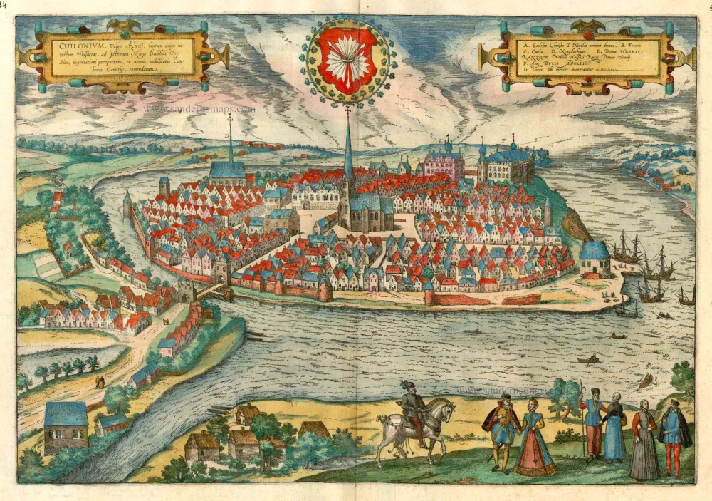


TRANSLATION OF CARTOUCHE TEXT: Chilonium, commonly called Kiel, is an elegant old city in Holstein on an isthmus in the Baltic Sea, noteworthy for a situation favourable to trade and commerce and the annual gatherings of the Cimbrian nobility.
COMMENTARY BY BRAUN: "Where the Belt meets the Duchy of Schleswig-Holstein and Schleswig, it has numerous bends forming narrow necks of land notably surrounded by water on both sides, which the ancient Greeks called an isthmus. Between these necks of land thrusts the sea to the great advantage of the residents, and it provides merchants and their sea-going vessels with a safe refuge where they can recover from the hardships sustained at sea. Kiel also provides an amenity of this kind, which is used similarly. It is an old city, well-supplied and almost surrounded by water. Its name derives from "Kiell" or "Keyl", which means chisel in German."
From an elevated vantage point and looking south, this view shows the island situation of the city systematically laid out on Kiel Fjord and surrounded by the Kleiner Kiel and pasture land. The centre is dominated by the Gothic church of St Nicolas (A). finished in 1240; it was joined by the church of the Holy Spirit (D) in the 14th century. The Holsten gate in the south led to the mainland. Founded by Count Adolf IV between 1233 and 1242, Kiel became a free city in 1242. Lacking links with inland waterways or good overland routes to larger cities, Kiel attained only regional importance as a trading port. One indication of modest circumstances is the dilapidated condition of the fortifications along the fjord. (Taschen)
Braun G. & Hogenberg F. and the Civitates Orbis Terrarum.
The Civitates Orbis Terrarum, also known as the 'Braun & Hogenberg', is a six-volume town atlas and the most excellent book of town views and plans ever published: 363 engravings, sometimes beautifully coloured. It was one of the best-selling works in the last quarter of the 16th century. Georg Braun, a skilled writer, wrote the text accompanying the plans and views on the verso. Many plates were engraved after the original drawings of a professional artist, Joris Hoefnagel (1542-1600). The first volume was published in Latin in 1572 and the sixth in 1617. Frans Hogenberg, a talented engraver, created the tables for volumes I through IV, and Simon van den Neuwel made those for volumes V and VI. Other contributors were cartographers Daniel Freese and Heinrich Rantzau, who provided valuable geographical information. Works by Jacob van Deventer, Sebastian Münster, and Johannes Stumpf were also used as references. Translations appeared in German and French, making the atlas accessible to a wider audience.
Since its original publication of volume 1 in 1572, the Civitates Orbis Terrarum has left an indelible mark on the history of cartography. The first volume was followed by seven more editions in 1575, 1577, 1582, 1588, 1593, 1599, and 1612. Vol.2, initially released in 1575, saw subsequent editions in 1597 and 1612. The subsequent volumes, each a treasure trove of historical insights, graced the world in 1581, 1588, 1593, 1599, and 1606. The German translation of the first volume, a testament to its widespread appeal, debuted in 1574, followed by the French edition in 1575.
Several printers were involved: Theodor Graminaeus, Heinrich von Aich, Gottfried von Kempen, Johannis Sinniger, Bertram Buchholtz, and Peter von Brachel, all of whom worked in Cologne.
Georg Braun (1541-1622)
Georg Braun, the author of the text accompanying the plans and views in the Civitates Orbis Terrarum, was born in Cologne in 1541. After his studies in Cologne, he entered the Jesuit Order as a novice, indicating his commitment to learning and intellectual pursuits. In 1561, he obtained his bachelor's degree; in 1562, he received his Magister Artium, further demonstrating his academic achievements. Although he left the Jesuit Order, he continued his studies in theology, gaining a licentiate in theology. His theological background likely influenced the content and tone of the text in the Civitates Orbis Terrarum, adding a unique perspective to the work.
Frans Hogenberg (1535-1590)
Frans Hogenberg was a Flemish and German painter, engraver, and mapmaker. He was born in Mechelen as the son of Nicolaas Hogenberg.
By the end of the 1560s, Frans Hogenberg was employed upon Abraham Ortelius's Theatrum Orbis Terrarum, published in 1570; he is named an engraver of numerous maps. In 1568, he was banned from Antwerp by the Duke of Alva and travelled to London, where he stayed a few years before emigrating to Cologne. He immediately embarked on his two most important works, the Civitates, published in 1572 and the Geschichtsblätter, which appeared in several series from 1569 until about 1587.
Thanks to large-scale projects like the Geschichtsblätter and the Civitates, Hogenberg's social circumstances improved with each passing year. He died as a wealthy man in Cologne in 1590.
Chilonium, vulgo Kyell.
Item Number: 15658 Authenticity Guarantee
Category: Antique maps > Europe > Germany - Cities
Old, antique bird’s-eye view plan of Kiel, by Georg Braun and Frans Hogenberg.
Title: Chilonium, vulgo Kyell.
Date of the first edition: 1588.
Date of this map: c. 1593.
Copper engraving, printed on paper.
Size (not including margins): 300 x 482mm (11.81 x 18.98 inches).
Verso: French text.
Condition: Original coloured, excellent.
Condition Rating: A+.
From: Liber Quartus - Théatre des Principales Villes de tout L'Univers. Cologne, c. 1593. (Van der Krogt 4, 41:3.4)
TRANSLATION OF CARTOUCHE TEXT: Chilonium, commonly called Kiel, is an elegant old city in Holstein on an isthmus in the Baltic Sea, noteworthy for a situation favourable to trade and commerce and the annual gatherings of the Cimbrian nobility.
COMMENTARY BY BRAUN: "Where the Belt meets the Duchy of Schleswig-Holstein and Schleswig, it has numerous bends forming narrow necks of land notably surrounded by water on both sides, which the ancient Greeks called an isthmus. Between these necks of land thrusts the sea to the great advantage of the residents, and it provides merchants and their sea-going vessels with a safe refuge where they can recover from the hardships sustained at sea. Kiel also provides an amenity of this kind, which is used similarly. It is an old city, well-supplied and almost surrounded by water. Its name derives from "Kiell" or "Keyl", which means chisel in German."
From an elevated vantage point and looking south, this view shows the island situation of the city systematically laid out on Kiel Fjord and surrounded by the Kleiner Kiel and pasture land. The centre is dominated by the Gothic church of St Nicolas (A). finished in 1240; it was joined by the church of the Holy Spirit (D) in the 14th century. The Holsten gate in the south led to the mainland. Founded by Count Adolf IV between 1233 and 1242, Kiel became a free city in 1242. Lacking links with inland waterways or good overland routes to larger cities, Kiel attained only regional importance as a trading port. One indication of modest circumstances is the dilapidated condition of the fortifications along the fjord. (Taschen)
Braun G. & Hogenberg F. and the Civitates Orbis Terrarum.
The Civitates Orbis Terrarum, also known as the 'Braun & Hogenberg', is a six-volume town atlas and the most excellent book of town views and plans ever published: 363 engravings, sometimes beautifully coloured. It was one of the best-selling works in the last quarter of the 16th century. Georg Braun, a skilled writer, wrote the text accompanying the plans and views on the verso. Many plates were engraved after the original drawings of a professional artist, Joris Hoefnagel (1542-1600). The first volume was published in Latin in 1572 and the sixth in 1617. Frans Hogenberg, a talented engraver, created the tables for volumes I through IV, and Simon van den Neuwel made those for volumes V and VI. Other contributors were cartographers Daniel Freese and Heinrich Rantzau, who provided valuable geographical information. Works by Jacob van Deventer, Sebastian Münster, and Johannes Stumpf were also used as references. Translations appeared in German and French, making the atlas accessible to a wider audience.
Since its original publication of volume 1 in 1572, the Civitates Orbis Terrarum has left an indelible mark on the history of cartography. The first volume was followed by seven more editions in 1575, 1577, 1582, 1588, 1593, 1599, and 1612. Vol.2, initially released in 1575, saw subsequent editions in 1597 and 1612. The subsequent volumes, each a treasure trove of historical insights, graced the world in 1581, 1588, 1593, 1599, and 1606. The German translation of the first volume, a testament to its widespread appeal, debuted in 1574, followed by the French edition in 1575.
Several printers were involved: Theodor Graminaeus, Heinrich von Aich, Gottfried von Kempen, Johannis Sinniger, Bertram Buchholtz, and Peter von Brachel, all of whom worked in Cologne.
Georg Braun (1541-1622)
Georg Braun, the author of the text accompanying the plans and views in the Civitates Orbis Terrarum, was born in Cologne in 1541. After his studies in Cologne, he entered the Jesuit Order as a novice, indicating his commitment to learning and intellectual pursuits. In 1561, he obtained his bachelor's degree; in 1562, he received his Magister Artium, further demonstrating his academic achievements. Although he left the Jesuit Order, he continued his studies in theology, gaining a licentiate in theology. His theological background likely influenced the content and tone of the text in the Civitates Orbis Terrarum, adding a unique perspective to the work.
Frans Hogenberg (1535-1590)
Frans Hogenberg was a Flemish and German painter, engraver, and mapmaker. He was born in Mechelen as the son of Nicolaas Hogenberg.
By the end of the 1560s, Frans Hogenberg was employed upon Abraham Ortelius's Theatrum Orbis Terrarum, published in 1570; he is named an engraver of numerous maps. In 1568, he was banned from Antwerp by the Duke of Alva and travelled to London, where he stayed a few years before emigrating to Cologne. He immediately embarked on his two most important works, the Civitates, published in 1572 and the Geschichtsblätter, which appeared in several series from 1569 until about 1587.
Thanks to large-scale projects like the Geschichtsblätter and the Civitates, Hogenberg's social circumstances improved with each passing year. He died as a wealthy man in Cologne in 1590.
Related items

Colonia 1493
Old, antique map - Double page panoramic view of Cologne (Köln) by H. Schedel
[Item number: 5306]
Patavia. 1493
Passau, by Hartmann Schedel.
[Item number: 10103]
Landshut 1599
Landshut, by Georg Braun and Frans Hogenberg.
[Item number: 24060]
Constancia 1493
Konstanz by Hartmann Schedel.
[Item number: 24392]
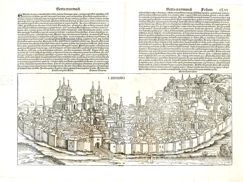
Erfordia 1493
Erfurt by Hartmann Schedel.
[Item number: 24394]