
Kleve, Duisburg, Emmerich, and Gennep, by Georg Braun and Frans Hogenberg. 1597
Braun G. & Hogenberg F. and the Civitates Orbis Terrarum.
The Civitates Orbis Terrarum, also known as the 'Braun & Hogenberg', is a six-volume town atlas and the most excellent book of town views and plans ever published: 363 engravings, sometimes beautifully coloured. It was one of the best-selling works in the last quarter of the 16th century. Georg Braun, a skilled writer, wrote the text accompanying the plans and views on the verso. Many plates were engraved after the original drawings of a professional artist, Joris Hoefnagel (1542-1600). The first volume was published in Latin in 1572 and the sixth in 1617. Frans Hogenberg, a talented engraver, created the tables for volumes I through IV, and Simon van den Neuwel made those for volumes V and VI. Other contributors were cartographers Daniel Freese and Heinrich Rantzau, who provided valuable geographical information. Works by Jacob van Deventer, Sebastian Münster, and Johannes Stumpf were also used as references. Translations appeared in German and French, making the atlas accessible to a broader audience.
Since its original publication of volume 1 in 1572, the Civitates Orbis Terrarum has left an indelible mark on the history of cartography. Seven more editions followed the first volume in 1575, 1577, 1582, 1588, 1593, 1599, and 1612. Vol.2, initially released in 1575, saw subsequent editions in 1597 and 1612. The subsequent volumes, each a treasure trove of historical insights, graced the world in 1581, 1588, 1593, 1599, and 1606. The German translation of the first volume, a testament to its widespread appeal, debuted in 1574, followed by the French edition in 1575.
Several printers were involved: Theodor Graminaeus, Heinrich von Aich, Gottfried von Kempen, Johannis Sinniger, Bertram Buchholtz, and Peter von Brachel, all of whom worked in Cologne.
Georg Braun (1541-1622)
Georg Braun, the author of the text accompanying the plans and views in the Civitates Orbis Terrarum, was born in Cologne in 1541. After his studies in Cologne, he entered the Jesuit Order as a novice, indicating his commitment to learning and intellectual pursuits. In 1561, he obtained his bachelor's degree; in 1562, he received his Magister Artium, further demonstrating his academic achievements. Although he left the Jesuit Order, he continued his studies in theology, gaining a licentiate in theology. His theological background likely influenced the content and tone of the text in the Civitates Orbis Terrarum, adding a unique perspective to the work.
Frans Hogenberg (1535-1590)
Frans Hogenberg was a Flemish and German painter, engraver, and mapmaker. He was born in Mechelen as the son of Nicolaas Hogenberg.
By the end of the 1560s, Frans Hogenberg was employed upon Abraham Ortelius's Theatrum Orbis Terrarum, published in 1570; he is named an engraver of numerous maps. In 1568, he was banned from Antwerp by the Duke of Alva and travelled to London, where he stayed a few years before emigrating to Cologne. He immediately embarked on his two most important works, the Civitates, published in 1572 and the Geschichtsblätter, which appeared in several series from 1569 until about 1587.
Thanks to large-scale projects like the Geschichtsblätter and the Civitates, Hogenberg's social circumstances improved with each passing year. He died as a wealthy man in Cologne in 1590.
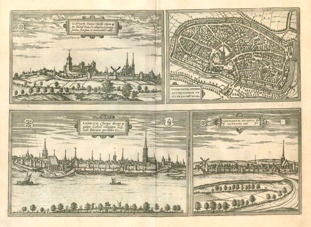
Cliviam, Ducatus Clivensis elegans opp: ... [on sheet with] Duisburgum, Oppidum Antiquissimum Vetus Francoru Regia [on sheet with] Embrica, Clivensis ditionis oppidum Ecclesia collegiata... [on sheet with] Gennapium, Ducatus Clivensis, Opp:
Item Number: 23988 Authenticity Guarantee
Category: Antique maps > Europe > Germany - Cities
Old, antique map with four bird's-eye views by Braun and Hogenberg: Kleve, Duisburg, Emmerich and Gennep.
KLEVE
TRANSLATION OF CARTOUCHE TEXT: Kleve, an elegant town in the Duchy of Cleves, renowned and remarkable for the famous ducal castle and the collegiate foundation.
COMMENTARY BY BRAUN: "The city of Kleve in the Duchy of Cleves is highly regarded because of its age and because the Duke of Jülich, Cleves and Berg has a splendid castle here, where he holds his princely court, and also because of its collegiate church."
This view of Kleve, seen from the direction of the Mühlberg, is dominated by the castle of the Counts and Dukes of Cleves, which has been called Schwanenburg since the 19th century after the legendary Knight of the Swan, Helias. The other building that dominates the silhouette of the city is the Gothic collegiate church of St Mary's Assumption. In the course of the changes carried out in the 15th century, the New City, known as the Hag Quarter, was founded. When the Cleves line died out on 1614, the city passed to Brandenburg. As a residence of the Electors of Brandenburg, Kleve took on the Baroque appearance that is still largely preserved today.
DUISBURG
CARTOUCHE: Duisburg, ancient town, old royal palace of the Franks.
COMMENTARY BY BRAUN: "Duisburg is a city in old Germany between the Ruhr and the Anger, in the old days the Rhine also flowed up to the city walls. As long as the city still bordered the Rhine, a fair was held here, which is now held in Frankfurt."
Duisburg is shown in a bird's-eye view from the west. In the middle of the city rises the late Gothic St Saviour's church, which dates back to the 9th century. This plate, which was faithfully reproduced by Merian even in 1647, also shows the harbour on the navigable dead arm of the Rhine, which gave the city great economic importance up to the 14th century. But in 1290, when Duisburg was pledged by King Rudolf I to Dietrich of Cleves, it lost its privileges and its imperial importance and sank into insignificance as a little farming town. The industrial revolution in the 19th century and the development of the inland port led to an economic upturn.
EMMERICH
CARTOUCHE: Emmerich, a town under the rule of Cleves, famous because of its collegiate church and a school.
COMMENTARY BY BRAUN: "Emmerich is a little town in the Duchy of Cleves with elegant buildings and a great religious foundation, built by St Willibrord himself. Here is a good elementary school, in which many learned men have received their basic education, for many industrious rectors have headed this school."
This view from the opposite bank of the Rhine shows the city of Emmerich, which is mentioned in a document for the first time in 828. The city grew up around a church erected by St Willibrord c. 700 on the site where the church of St Aldegund with late medieval sculptures. In 1233 Emmerich was granted a municipal charter and in 1407 it became a member of the Hanseatic League.
GENAPPE
CARTOUCHE: Genappe, town in the Duchy of Cleves.
This town is located on the Dyle south of Brussels and is shown in the place set in a picturesque landscape, an impression that is reinforced by the windmill. Towards the end of the 12th century the Dukes of Brabant erected a fortress here on the banks of the Dyle, which grew into a little town in the 13th and 14th centuries. In the 15th century the future King Louis XI lived in the castle of Genappe. The town lost its importance as a result of the plague in 1533 and due to religious conflicts in 1578.
Date of the first edition: 1575
Date of this map: 1597
Copper engraving
Size: 34.5 x 49cm (13.5 x 19.1 inches)
Verso text: Latin
Condition: Uncoloured, excellent.
Condition Rating: A
References: Van der Krogt 4, 2061; Taschen, Braun and Hogenberg, p.171.
From: Civitates Orbis Terrarum, ... Part 2: De Praecipuis, Totius Universi Urbibus, Liber Secundus. Köln, Bertram Buchholz, 1597. (Van der Krogt 4, 41:1.2)
Braun G. & Hogenberg F. and the Civitates Orbis Terrarum.
The Civitates Orbis Terrarum, also known as the 'Braun & Hogenberg', is a six-volume town atlas and the most excellent book of town views and plans ever published: 363 engravings, sometimes beautifully coloured. It was one of the best-selling works in the last quarter of the 16th century. Georg Braun, a skilled writer, wrote the text accompanying the plans and views on the verso. Many plates were engraved after the original drawings of a professional artist, Joris Hoefnagel (1542-1600). The first volume was published in Latin in 1572 and the sixth in 1617. Frans Hogenberg, a talented engraver, created the tables for volumes I through IV, and Simon van den Neuwel made those for volumes V and VI. Other contributors were cartographers Daniel Freese and Heinrich Rantzau, who provided valuable geographical information. Works by Jacob van Deventer, Sebastian Münster, and Johannes Stumpf were also used as references. Translations appeared in German and French, making the atlas accessible to a broader audience.
Since its original publication of volume 1 in 1572, the Civitates Orbis Terrarum has left an indelible mark on the history of cartography. Seven more editions followed the first volume in 1575, 1577, 1582, 1588, 1593, 1599, and 1612. Vol.2, initially released in 1575, saw subsequent editions in 1597 and 1612. The subsequent volumes, each a treasure trove of historical insights, graced the world in 1581, 1588, 1593, 1599, and 1606. The German translation of the first volume, a testament to its widespread appeal, debuted in 1574, followed by the French edition in 1575.
Several printers were involved: Theodor Graminaeus, Heinrich von Aich, Gottfried von Kempen, Johannis Sinniger, Bertram Buchholtz, and Peter von Brachel, all of whom worked in Cologne.
Georg Braun (1541-1622)
Georg Braun, the author of the text accompanying the plans and views in the Civitates Orbis Terrarum, was born in Cologne in 1541. After his studies in Cologne, he entered the Jesuit Order as a novice, indicating his commitment to learning and intellectual pursuits. In 1561, he obtained his bachelor's degree; in 1562, he received his Magister Artium, further demonstrating his academic achievements. Although he left the Jesuit Order, he continued his studies in theology, gaining a licentiate in theology. His theological background likely influenced the content and tone of the text in the Civitates Orbis Terrarum, adding a unique perspective to the work.
Frans Hogenberg (1535-1590)
Frans Hogenberg was a Flemish and German painter, engraver, and mapmaker. He was born in Mechelen as the son of Nicolaas Hogenberg.
By the end of the 1560s, Frans Hogenberg was employed upon Abraham Ortelius's Theatrum Orbis Terrarum, published in 1570; he is named an engraver of numerous maps. In 1568, he was banned from Antwerp by the Duke of Alva and travelled to London, where he stayed a few years before emigrating to Cologne. He immediately embarked on his two most important works, the Civitates, published in 1572 and the Geschichtsblätter, which appeared in several series from 1569 until about 1587.
Thanks to large-scale projects like the Geschichtsblätter and the Civitates, Hogenberg's social circumstances improved with each passing year. He died as a wealthy man in Cologne in 1590.
Related items

Gorlitz - Gorlitium, Urbs Superioris Lusatiae, ad vivum delineata, Anno Salutis MDLXXV 1576
Gorlitz, by Georg Braun and Frans Hogenberg.
[Item number: 4057]

Landshut 1599
Landshut, by Georg Braun and Frans Hogenberg.
[Item number: 24060]

Het Logiment der H.H. Staten generael in 't Klooster St. Aechten + ...t Dorp Middelaer + ... Het Huys te Gennep + ... Het Dorp Offel + ... Het Huys te Middelaer + ... De Uytstroomùende Niers. 1652
Six views of the vicinity of Gennep, by Joan Blaeu.
[Item number: 26012]

Clivia Ducatus et Ravesteind Dominium. 1643
Kleve, by Joan Blaeu.
[Item number: 29335]
Rare!
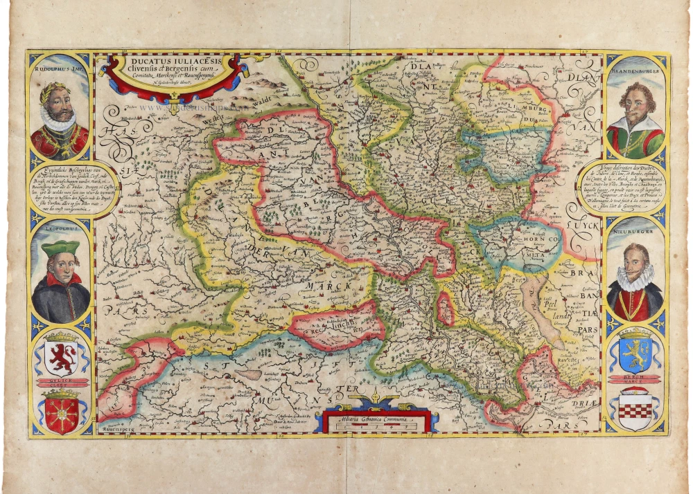
Ducatus Iuliace[n]sis, Clivensis et Bergensis cum Comitatu Merckensi et Ravensbergensi. 1630
Jülich - Kleve - Berg by Nicolaes van Geelkercken, published by Joannes Janssonius
[Item number: 32697]