
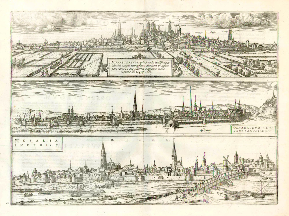
Münster, Osnabrück, and Wesel, by Georg Braun and Frans Hogenberg. 1577
The item displayed on this page has been sold. However, we have a similar map in stock:
Munster - Osnabruck - Wesel by Braun & Hogenberg 1582
Monasterium, Urbs in Media Westphalia Celeberrimi ...
[Item number: 25492]
![Monasterium, Urbs in Media Westphalia Celeberrimi Nominis ... [on sheet with] Osnabrugum Elegans Saxoniae Opp. [and] Wesalia Inferior.](https://sanderusmaps.com/assets/RESIZED/thumb_m25492.jpg)
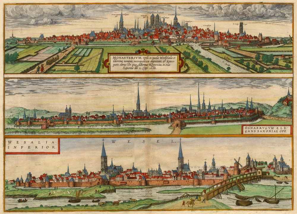
MÜNSTER
TRANSLATION OF CARTOUCHE TEXT: Münster, a city with a famous name situated in the middle of Westphalia, is distinguished as a capital and a cathedral city; Albert Krantz mentions it in his Saxonia, 1520.
COMMENTARY BY BRAUN: "Münster is a large and fortified city, capital of the province of Westphalia [...]. Although the Anabaptists destroyed this city, the walls torn down, the gates damaged by constant bombardment and nothing left unscathed in the churches either, the city was nevertheless rebuilt and is now considered the most beautiful and strongest of all the other cities of Westphalia; the inhabitants live from trade and craft. [...] A good beer is also brewed here, which the people of Münster call Keute and is very similar to the Hamburg beer."
The engraving shows a view of Münster from the southwest and devotes much attention to the surrounding countryside with its windmills, neat fields, and the dramatic clouds overhead. The well-fortified city is hallmarked by its churches and steeples, including the Überwasser church on the left, the soaring cathedral of St Paul's in the centre, St Lambert's church on the right and St Ludgerius's church on the far right. In the foreground, Münster's fortifications include defensive works protecting the point at which the River Aa flows into the city. Münster was granted its charter in 1170 and joined the Hanseatic League in the mid-1300s. The city's economic prosperity during this period is reflected even today in its primary market square, the Prinzipal-Markt. The Münster Rebellion of 1534/35, when Protestant Anabaptists temporarily took over the city's running, was particularly significant. In June 1535, after a lengthy siege, the city was starved out and stormed by Bishop Franz von Waldeck. The Anabaptists were executed, and - as a deterrent - their corpses were displayed in iron baskets hung from St Lambert's steeple.
OSNABRÜCK
COMMENTARY BY BRAUN: "Emperor Charlemagne built a church here in honour of SS Peter and Crispin. Osnabrück has two monasteries, conducts much trade, does a good business in grey cloth and linen, and lies in an attractive valley on the River Hase. Good beer is made here, called Büse. [...] Since Emperor Charlemagne particularly liked this city, he also granted it privileges: he ordered the building of a school in which Greek and Latin were taught."
Like those preceding and following it, the engraving of Osnabrück is seen from the relatively low perspective of someone approaching the city, in this case from Klushügel Hill. The many churches dominate the view: St Peter's cathedral on the left, whose two massive towers still hallmark the skyline today. In the centre, the late Gothic three-aisled church of St Catherine, with its 103-m-high spire, is the tallest medieval building in Lower Saxony. Osnabrück developed after AD 780 around the see created by Charlemagne. The city's name probably derives from the Lower Saxon words Ossen and Brügge, meaning "ox bridge". The Peace of Westphalia was concluded in 1648 in the late Gothic town hall.
WESEL
COMMENTARY BY BRAUN: "The Cleves city of Lower Wesel, where the Lippe flows into the Rhine, is graced with wealth and renown, numerous buildings and flourishing commerce. [...] The city benefits greatly from the Rhine flowing past, which often alters its usual course and moves westward towards the sea and away from the city. [...] As a particular token of the charity of the highly esteemed and learned Heinrich Olichschleger the Elder, a hospital was built for elderly men in need, to whom he assures an annual living through his benevolence."
The view shows the city of Wesel from the south, where the Lippe joins the Rhine. Recognisable on the left is St Willibrod's cathedral, only recently expanded into a five-aisled church, and on the right, the filial church of SS Nicholas and Antony, known as the Mathenakirche, after its location in the Mathena district. The boat with the bulbous hull in the foreground is based on Netherlandish ocean-going vessels and was suitable for sailing and towing (i.e. by horses or people towing the boat upstream). The home for the elderly, as mentioned by Braun and endowed by Heinrich Olichschleger in 1524, was one of the private foundations that typically housed six to twelve elderly people; in this particular case, the hospital accommodated twelve men and six women in separate buildings. (Taschen)
Braun G. & Hogenberg F. and the Civitates Orbis Terrarum.
The Civitates Orbis Terrarum, also known as the 'Braun & Hogenberg', is a six-volume town atlas and the most excellent book of town views and plans ever published: 363 engravings, sometimes beautifully coloured. It was one of the best-selling works in the last quarter of the 16th century. Georg Braun, a skilled writer, wrote the text accompanying the plans and views on the verso. Many plates were engraved after the original drawings of a professional artist, Joris Hoefnagel (1542-1600). The first volume was published in Latin in 1572 and the sixth in 1617. Frans Hogenberg, a talented engraver, created the tables for volumes I through IV, and Simon van den Neuwel made those for volumes V and VI. Other contributors were cartographers Daniel Freese and Heinrich Rantzau, who provided valuable geographical information. Works by Jacob van Deventer, Sebastian Münster, and Johannes Stumpf were also used as references. Translations appeared in German and French, making the atlas accessible to a wider audience.
Since its original publication of volume 1 in 1572, the Civitates Orbis Terrarum has left an indelible mark on the history of cartography. The first volume was followed by seven more editions in 1575, 1577, 1582, 1588, 1593, 1599, and 1612. Vol.2, initially released in 1575, saw subsequent editions in 1597 and 1612. The subsequent volumes, each a treasure trove of historical insights, graced the world in 1581, 1588, 1593, 1599, and 1606. The German translation of the first volume, a testament to its widespread appeal, debuted in 1574, followed by the French edition in 1575.
Several printers were involved: Theodor Graminaeus, Heinrich von Aich, Gottfried von Kempen, Johannis Sinniger, Bertram Buchholtz, and Peter von Brachel, all of whom worked in Cologne.
Georg Braun (1541-1622)
Georg Braun, the author of the text accompanying the plans and views in the Civitates Orbis Terrarum, was born in Cologne in 1541. After his studies in Cologne, he entered the Jesuit Order as a novice, indicating his commitment to learning and intellectual pursuits. In 1561, he obtained his bachelor's degree; in 1562, he received his Magister Artium, further demonstrating his academic achievements. Although he left the Jesuit Order, he continued his studies in theology, gaining a licentiate in theology. His theological background likely influenced the content and tone of the text in the Civitates Orbis Terrarum, adding a unique perspective to the work.
Frans Hogenberg (1535-1590)
Frans Hogenberg was a Flemish and German painter, engraver, and mapmaker. He was born in Mechelen as the son of Nicolaas Hogenberg.
By the end of the 1560s, Frans Hogenberg was employed upon Abraham Ortelius's Theatrum Orbis Terrarum, published in 1570; he is named an engraver of numerous maps. In 1568, he was banned from Antwerp by the Duke of Alva and travelled to London, where he stayed a few years before emigrating to Cologne. He immediately embarked on his two most important works, the Civitates, published in 1572 and the Geschichtsblätter, which appeared in several series from 1569 until about 1587.
Thanks to large-scale projects like the Geschichtsblätter and the Civitates, Hogenberg's social circumstances improved with each passing year. He died as a wealthy man in Cologne in 1590.
Monasterium, Urbs in Media Westphalia Celeberrimi Nominis ... [on sheet with] Osnabrugum Elegans Saxoniae Opp. [and] Wesalia Inferior.
Item Number: 18794 Authenticity Guarantee
Category: Antique maps > Europe > Germany - Cities
Old, antique bird’s-eye view plan of Münster, Osnabrück, and Wesel, by Georg Braun and Frans Hogenberg.
Title: Monasterium, Urbs in Media Westphalia Celeberrimi Nominis ... [on sheet with] Osnabrugum Elegans Saxoniae Opp. [and] Wesalia Inferior.
Date of the first edition: 1572.
Date of this map: 1577.
Copper engraving, printed on paper.
Size (not including margins): 340 x 465mm (13.39 x 18.31 inches).
Verso: Latin text.
Condition: Original coloured., excellent.
Condition Rating: A+.
From: Civitates Orbis Terrarum, Liber Primus. Köln, Gottfried von Kempen, 1577. (Van der Krogt 4, 41:1.1)
MÜNSTER
TRANSLATION OF CARTOUCHE TEXT: Münster, a city with a famous name situated in the middle of Westphalia, is distinguished as a capital and a cathedral city; Albert Krantz mentions it in his Saxonia, 1520.
COMMENTARY BY BRAUN: "Münster is a large and fortified city, capital of the province of Westphalia [...]. Although the Anabaptists destroyed this city, the walls torn down, the gates damaged by constant bombardment and nothing left unscathed in the churches either, the city was nevertheless rebuilt and is now considered the most beautiful and strongest of all the other cities of Westphalia; the inhabitants live from trade and craft. [...] A good beer is also brewed here, which the people of Münster call Keute and is very similar to the Hamburg beer."
The engraving shows a view of Münster from the southwest and devotes much attention to the surrounding countryside with its windmills, neat fields, and the dramatic clouds overhead. The well-fortified city is hallmarked by its churches and steeples, including the Überwasser church on the left, the soaring cathedral of St Paul's in the centre, St Lambert's church on the right and St Ludgerius's church on the far right. In the foreground, Münster's fortifications include defensive works protecting the point at which the River Aa flows into the city. Münster was granted its charter in 1170 and joined the Hanseatic League in the mid-1300s. The city's economic prosperity during this period is reflected even today in its primary market square, the Prinzipal-Markt. The Münster Rebellion of 1534/35, when Protestant Anabaptists temporarily took over the city's running, was particularly significant. In June 1535, after a lengthy siege, the city was starved out and stormed by Bishop Franz von Waldeck. The Anabaptists were executed, and - as a deterrent - their corpses were displayed in iron baskets hung from St Lambert's steeple.
OSNABRÜCK
COMMENTARY BY BRAUN: "Emperor Charlemagne built a church here in honour of SS Peter and Crispin. Osnabrück has two monasteries, conducts much trade, does a good business in grey cloth and linen, and lies in an attractive valley on the River Hase. Good beer is made here, called Büse. [...] Since Emperor Charlemagne particularly liked this city, he also granted it privileges: he ordered the building of a school in which Greek and Latin were taught."
Like those preceding and following it, the engraving of Osnabrück is seen from the relatively low perspective of someone approaching the city, in this case from Klushügel Hill. The many churches dominate the view: St Peter's cathedral on the left, whose two massive towers still hallmark the skyline today. In the centre, the late Gothic three-aisled church of St Catherine, with its 103-m-high spire, is the tallest medieval building in Lower Saxony. Osnabrück developed after AD 780 around the see created by Charlemagne. The city's name probably derives from the Lower Saxon words Ossen and Brügge, meaning "ox bridge". The Peace of Westphalia was concluded in 1648 in the late Gothic town hall.
WESEL
COMMENTARY BY BRAUN: "The Cleves city of Lower Wesel, where the Lippe flows into the Rhine, is graced with wealth and renown, numerous buildings and flourishing commerce. [...] The city benefits greatly from the Rhine flowing past, which often alters its usual course and moves westward towards the sea and away from the city. [...] As a particular token of the charity of the highly esteemed and learned Heinrich Olichschleger the Elder, a hospital was built for elderly men in need, to whom he assures an annual living through his benevolence."
The view shows the city of Wesel from the south, where the Lippe joins the Rhine. Recognisable on the left is St Willibrod's cathedral, only recently expanded into a five-aisled church, and on the right, the filial church of SS Nicholas and Antony, known as the Mathenakirche, after its location in the Mathena district. The boat with the bulbous hull in the foreground is based on Netherlandish ocean-going vessels and was suitable for sailing and towing (i.e. by horses or people towing the boat upstream). The home for the elderly, as mentioned by Braun and endowed by Heinrich Olichschleger in 1524, was one of the private foundations that typically housed six to twelve elderly people; in this particular case, the hospital accommodated twelve men and six women in separate buildings. (Taschen)
Braun G. & Hogenberg F. and the Civitates Orbis Terrarum.
The Civitates Orbis Terrarum, also known as the 'Braun & Hogenberg', is a six-volume town atlas and the most excellent book of town views and plans ever published: 363 engravings, sometimes beautifully coloured. It was one of the best-selling works in the last quarter of the 16th century. Georg Braun, a skilled writer, wrote the text accompanying the plans and views on the verso. Many plates were engraved after the original drawings of a professional artist, Joris Hoefnagel (1542-1600). The first volume was published in Latin in 1572 and the sixth in 1617. Frans Hogenberg, a talented engraver, created the tables for volumes I through IV, and Simon van den Neuwel made those for volumes V and VI. Other contributors were cartographers Daniel Freese and Heinrich Rantzau, who provided valuable geographical information. Works by Jacob van Deventer, Sebastian Münster, and Johannes Stumpf were also used as references. Translations appeared in German and French, making the atlas accessible to a wider audience.
Since its original publication of volume 1 in 1572, the Civitates Orbis Terrarum has left an indelible mark on the history of cartography. The first volume was followed by seven more editions in 1575, 1577, 1582, 1588, 1593, 1599, and 1612. Vol.2, initially released in 1575, saw subsequent editions in 1597 and 1612. The subsequent volumes, each a treasure trove of historical insights, graced the world in 1581, 1588, 1593, 1599, and 1606. The German translation of the first volume, a testament to its widespread appeal, debuted in 1574, followed by the French edition in 1575.
Several printers were involved: Theodor Graminaeus, Heinrich von Aich, Gottfried von Kempen, Johannis Sinniger, Bertram Buchholtz, and Peter von Brachel, all of whom worked in Cologne.
Georg Braun (1541-1622)
Georg Braun, the author of the text accompanying the plans and views in the Civitates Orbis Terrarum, was born in Cologne in 1541. After his studies in Cologne, he entered the Jesuit Order as a novice, indicating his commitment to learning and intellectual pursuits. In 1561, he obtained his bachelor's degree; in 1562, he received his Magister Artium, further demonstrating his academic achievements. Although he left the Jesuit Order, he continued his studies in theology, gaining a licentiate in theology. His theological background likely influenced the content and tone of the text in the Civitates Orbis Terrarum, adding a unique perspective to the work.
Frans Hogenberg (1535-1590)
Frans Hogenberg was a Flemish and German painter, engraver, and mapmaker. He was born in Mechelen as the son of Nicolaas Hogenberg.
By the end of the 1560s, Frans Hogenberg was employed upon Abraham Ortelius's Theatrum Orbis Terrarum, published in 1570; he is named an engraver of numerous maps. In 1568, he was banned from Antwerp by the Duke of Alva and travelled to London, where he stayed a few years before emigrating to Cologne. He immediately embarked on his two most important works, the Civitates, published in 1572 and the Geschichtsblätter, which appeared in several series from 1569 until about 1587.
Thanks to large-scale projects like the Geschichtsblätter and the Civitates, Hogenberg's social circumstances improved with each passing year. He died as a wealthy man in Cologne in 1590.
Related items
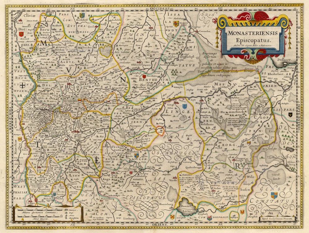
Monasteriensis Episcopatus 1659-72
Munster, by J. Blaeu.
[Item number: 9682]
No title. 1619
Westfalen (Central), by Gerard Mercator.
[Item number: 12586]
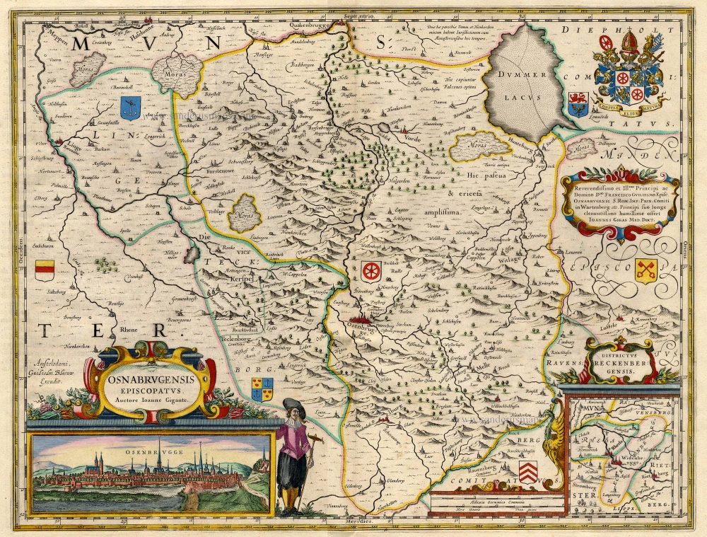
Osnabrugensis Episcopatus. 1645-58
Osnabrück, by J. Janssonius.
[Item number: 18666]
Monasteriensis Episcopatus. 1642-43
Münster, by Blaeu W.
[Item number: 18716]
Osnabrugensis Episcopatus. 1642-43
Osnabrück, by Blaeu W.
[Item number: 18729]
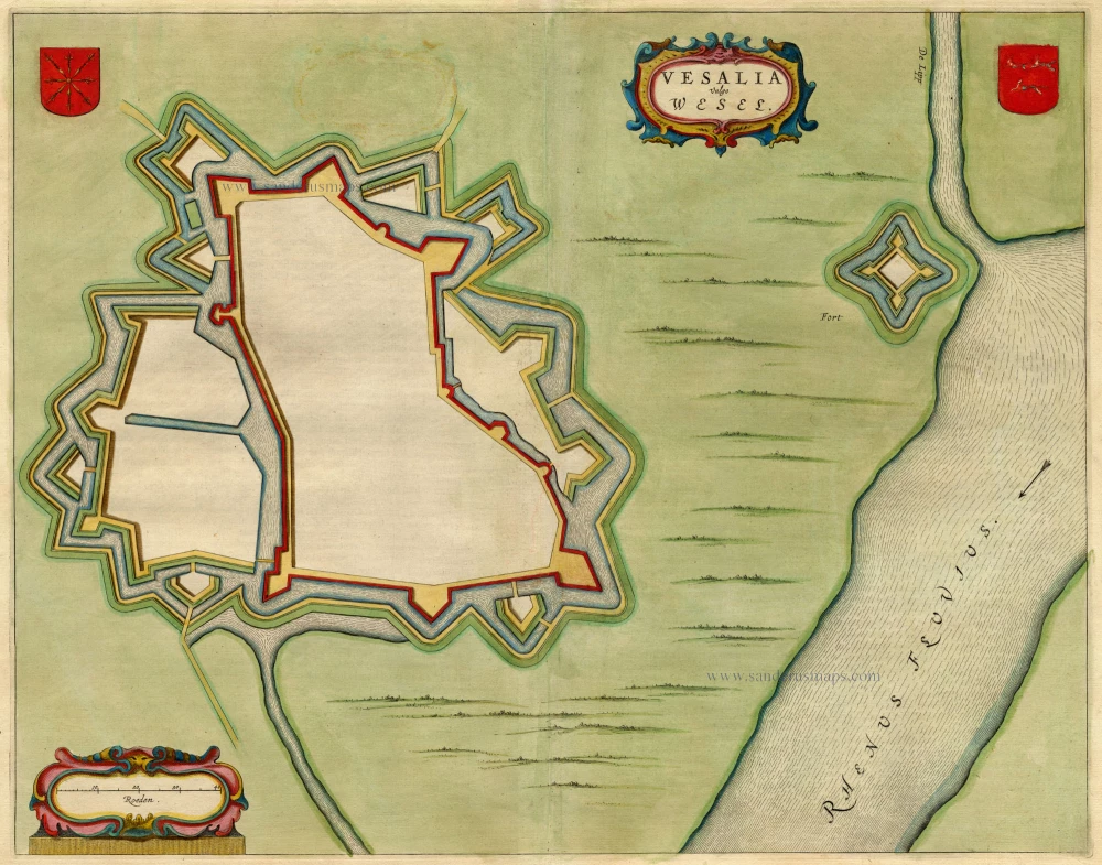
Vesalia - Wesel 1649
Wesel, by Blaeu J.
[Item number: 19687]
Monasterium, Urbs in Media Westphalia Celeberrimi Nominis ... [on sheet with] Osnabrugum Elegans Saxoniae Opp. [and] Wesalia Inferior. 1612
Münster, Osnabrück and Wesel, by Georg Braun and Frans Hogenberg.
[Item number: 22320]
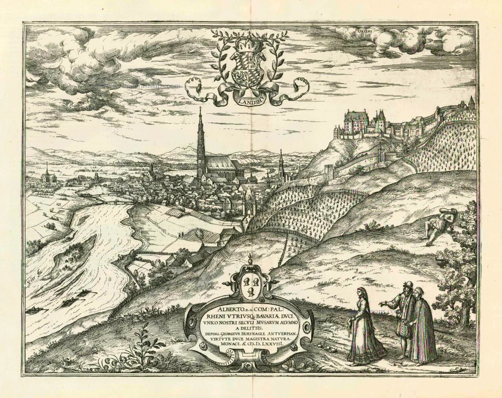
Landshut 1599
Landshut, by Georg Braun and Frans Hogenberg.
[Item number: 24060]