
Rare!
Jülich - Kleve - Berg by Nicolaes van Geelkercken, published by Joannes Janssonius 1630
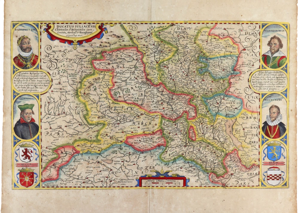
The purpose of the map is stated in subtitles in French and Dutch in the side borders: the war between the Emperor and the German Electors. The side borders show, in addition to the text in the cartouche, the coats of arms of the regions Gulick, Cleef, Bergh, and Marck and the portraits of the four leading players in the struggle: Rudolphus Imp., Leopoldus, Brandenburger (Marquis Ernst, brother of elector Johann Sigismund von Brandenburg) and Nieuburger (Crown Prince Wolfgang Wilhelm von Pfalz-Neuburg). The geographical content is based on a compilation of various regional maps from Mercator's atlas of 1585.
The Janssonius Family
Joannes Janssonius (Arnhem, 1588-1664), son of the Arnhem publisher Jan Janssen, married Elisabeth Hondius, daughter of Jodocus Hondius, in Amsterdam in 1612. After his marriage, he settled down in this town as a bookseller and publisher of cartographic material. In 1618, he established himself in Amsterdam next door to Blaeu’s bookshop. He entered into serious competition with Willem Jansz. Blaeu when copying Blaeu’s Licht der Zeevaert after the expiration of the privilege in 1620. His activities concerned the publication of atlases, books, single maps, and an extensive book trade with branches in Frankfurt, Danzig, Stockholm, Copenhagen, Berlin, Koningsbergen, Geneva, and Lyon. In 1631, he began publishing atlases together with Henricus Hondius.
In the early 1640s, Henricus Hondius left the atlas publishing business to Janssonius. Competition with Joan Blaeu, Willem’s son and successor, in atlas production, prompted Janssonius to enlarge his Atlas Novus finally into a work of six volumes, into which a sea atlas and an atlas of the Old World were inserted. Other atlases published by Janssonius are Mercator’s Atlas Minor, Hornius’s historical atlas (1652), the townbooks in eight volumes (1657), Cellarius’s Atlas Coelestis and several sea atlases and pilot guides.
After the death of Joannes Janssonius, the shop and publishing firm were continued by the heirs under the direction of Johannes van Waesbergen (c. 1616-1681), son-in-law of Joannes Janssonius. Van Waesbergen added Janssonius's name to his own.
In 1676, Joannes Janssonius’s heirs sold by auction “all the remaining Atlases in Latin, French, High and Low German, as well as the Stedeboecken in Latin, in 8 volumes, bound and unbound, maps, plates belonging to the Atlas and Stedeboecken.” The copperplates from Janssonius’s atlases were afterwards sold to Schenk and Valck.
Nicolaes van Geelkercken (c.1585-1656)
Cartographer, engraver and surveyor of Amsterdam and Friesland (1614-1616), Leiden (1616-1628) and Arnhem (1628-1656).
Ducatus Iuliace[n]sis, Clivensis et Bergensis cum Comitatu Merckensi et Ravensbergensi.
Item Number: 32697 Authenticity Guarantee
Category: Antique maps > Europe > Germany
Jülich - Kleve - Berg by Nicolaes van Geelkercken, published by Joannes Janssonius.
Title: Ducatus Iuliace[n]sis, Clivensis et Bergensis cum Comitatu Merckensi et Ravensbergensi.
N. Geilenkerckensis delineat.
Eygentlicke Beschryvinge van de Hertochdommen van Gulick, Cleef, ende Bergh, ende de Graefschappen van der Marck, ende Revensperg, met alle de Steden, Dorpen ende Casteelen: uyt de welcke men sien can waer die tegenwordige Oorloge is tusschen den Keyser ende die Duytsche Vorsten; alles op sijn seker mate nae die const van Geometria.
T'Amsterdam Gedruckt Bij Dauijt de Meine Inde Werelt Cart.
Cartographer: Nicolaes van Geelkercken.
Date: 1630.
Copper engraving, printed on paper.
Image size: 320 x 545mm (12½ x 21½ inches).
Sheet size: 470 x 575mm (18½ x 22¾ inches).
Verso: Blank.
Condition: Hand-coloured, excellent.
Condition Rating: A+.
From: Atlantis Maioris Appendix, sive Pars Altera, ... Amsterdam, J. Janssonius, 1630. (Van der Krogt 1, 1:202)
The purpose of the map is stated in subtitles in French and Dutch in the side borders: the war between the Emperor and the German Electors. The side borders show, in addition to the text in the cartouche, the coats of arms of the regions Gulick, Cleef, Bergh, and Marck and the portraits of the four leading players in the struggle: Rudolphus Imp., Leopoldus, Brandenburger (Marquis Ernst, brother of elector Johann Sigismund von Brandenburg) and Nieuburger (Crown Prince Wolfgang Wilhelm von Pfalz-Neuburg). The geographical content is based on a compilation of various regional maps from Mercator's atlas of 1585.
The Janssonius Family
Joannes Janssonius (Arnhem, 1588-1664), son of the Arnhem publisher Jan Janssen, married Elisabeth Hondius, daughter of Jodocus Hondius, in Amsterdam in 1612. After his marriage, he settled down in this town as a bookseller and publisher of cartographic material. In 1618, he established himself in Amsterdam next door to Blaeu’s bookshop. He entered into serious competition with Willem Jansz. Blaeu when copying Blaeu’s Licht der Zeevaert after the expiration of the privilege in 1620. His activities concerned the publication of atlases, books, single maps, and an extensive book trade with branches in Frankfurt, Danzig, Stockholm, Copenhagen, Berlin, Koningsbergen, Geneva, and Lyon. In 1631, he began publishing atlases together with Henricus Hondius.
In the early 1640s, Henricus Hondius left the atlas publishing business to Janssonius. Competition with Joan Blaeu, Willem’s son and successor, in atlas production, prompted Janssonius to enlarge his Atlas Novus finally into a work of six volumes, into which a sea atlas and an atlas of the Old World were inserted. Other atlases published by Janssonius are Mercator’s Atlas Minor, Hornius’s historical atlas (1652), the townbooks in eight volumes (1657), Cellarius’s Atlas Coelestis and several sea atlases and pilot guides.
After the death of Joannes Janssonius, the shop and publishing firm were continued by the heirs under the direction of Johannes van Waesbergen (c. 1616-1681), son-in-law of Joannes Janssonius. Van Waesbergen added Janssonius's name to his own.
In 1676, Joannes Janssonius’s heirs sold by auction “all the remaining Atlases in Latin, French, High and Low German, as well as the Stedeboecken in Latin, in 8 volumes, bound and unbound, maps, plates belonging to the Atlas and Stedeboecken.” The copperplates from Janssonius’s atlases were afterwards sold to Schenk and Valck.
Nicolaes van Geelkercken (c.1585-1656)
Cartographer, engraver and surveyor of Amsterdam and Friesland (1614-1616), Leiden (1616-1628) and Arnhem (1628-1656).
Related items

Schenken-Schans + Het Tolhuis + Griethuisen + 'T Huis te Hal + Christina oft Nieu Schenckenschans 1652
Five, views of Kleve - Schenkenschans by Joan Blaeu.
[Item number: 5313]

De Ghelegentheyt ende Belegheringhe van Schencken-Schans 1649
The siege of Schenkenschanz (Kleve) in 1635-36, by J. Blaeu
[Item number: 9168]

Le Duché de Cleves. 1683-1696
Kleve, by Visscher N. II
[Item number: 10654]

Iuliacensis et Montensis Ducatus. - De Hertoghdomen Gulick en Berghe. 1635
Jülich and Berg, by Willem and Joan Blaeu.
[Item number: 10774]

Clivia Ducatus et Ravesteind Dominium 1645-58
Kleve, by Janssonius J.
[Item number: 19441]

Le Duche de Cleves la Seigneurie de Ravenstein et le Comte de Meurs 1710
Cleves (Kleve), by Jaillot - Covens & Mortier.
[Item number: 23841]

Le Duché de Juliers, l'Abbaye de St Cornelis Munster, la Baronie de Wickrad, et la ville impériale d'Aix la Chapelle. 1721-41
Jülich, by Covens & Mortier.
[Item number: 23845]
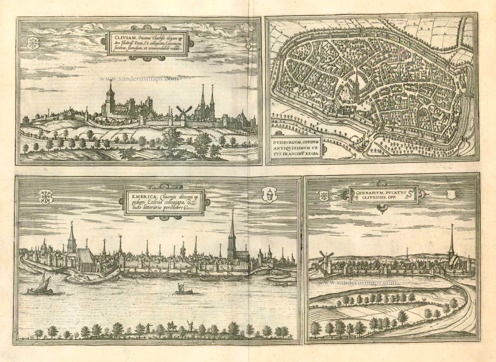
Cliviam, Ducatus Clivensis elegans opp: ... [on sheet with] Duisburgum, Oppidum Antiquissimum Vetus Francoru Regia [on sheet with] Embrica, Clivensis ditionis oppidum Ecclesia collegiata... [on sheet with] Gennapium, Ducatus Clivensis, Opp: 1597
Kleve, Duisburg, Emmerich, and Gennep, by Georg Braun and Frans Hogenberg.
[Item number: 23988]

Clivia Ducatus et Ravesteind Dominium. 1643
Kleve, by Joan Blaeu.
[Item number: 29335]