
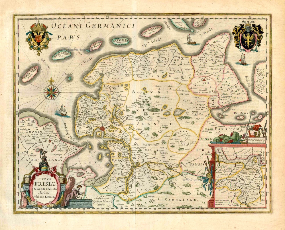
Ost-Friesland by Petrus Kaerius (Pieter Van den Keere). 1622
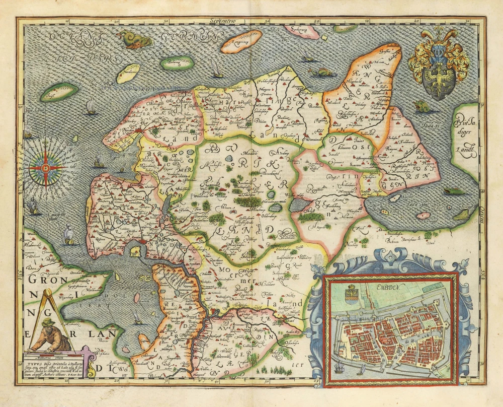
This map is based on the cartographical work of the learned Ubbo Emmius (1547-1625), one of the most important personages in the history of Eastern Friesland. It was first published in Emden and later in Amsterdam by Cornelis Claesz. in 1599. After the death of Cornelis Claesz. (1609), Pieter van den Keere purchased several copperplates at the auction of his estate the following year. Among them was Ubbo Emmius's map of Eastern Friesland.
In 1617, he used this copperplate (and two others) to publish his Germania Inferior. The original copperplate was too big, so he adapted the plate to fit in with the other atlas sheets. The copperplate was sawn off; roughly 2.5 cm was removed on the lower edge, and about 4.5 cm was sawn off the left side. Further, graduation of degrees of longitude and latitude was added along the borders, though no change was made in the topographical content.
Removing both cartouches on the left side changed the visual image of the map. In their place, within an opened pair of dividers, Van den Keere now engraved a surveyor taking measurements. Below, in a rectangular cartouche, the title of the older small cartouche from the previous state is included anew. The only part of the author's name that remains is Ubone. After that comes the name of the new publisher: P. Keer. Exc.
Pieter Van den Keere (Petrus Kaerius) (1571-c.1650)
Pieter van den Keere was born in Ghent in 1571 as the son of the type-founder, Hendrik van den Keere. In 1584, he moved with his family to London for religious reasons. There, Van den Keere received training as an engraver from Jodocus Hondius, his brother-in-law. Not only the companionship with Jodocus Hondius but also the acquaintanceship with Pieter van den Berghe (Petrus Montanus), author of the text of the Germania Inferior, originates from the years of refuge in London.
Upon their settlement in Amsterdam in 1593, both Keere and Hondius embarked on a monumental project. Their collaboration resulted in the creation of a large wall map of Europe, a masterpiece that still stands as a testament to their skill and vision, dated 1595: Nova totius Europae descriptio.
In 1610, he set up a workshop in the Kalverstraat that he called ‘In den onseeckeren tijd’ (In the uncertain time). During this period, he made numerous copperplates, including maps for his Atlas of the Netherlands and the Atlas Minor published by Jodocus Hondius.
The Germania Inferior (1617) is the first original atlas of the Netherlands published in folio size. The text for the atlas, both in Dutch and in French, was written by Petrus Montanus. After 1623, Claes Jansz. Visscher bought the plates and substituted his name for Kaerius’s. In 1634, Visscher included many of these maps in his Germana Inferior.
Kaerius's fame is not only based on his atlas of the Netherlands. He is even better known as an engraver of many loose-leaf maps and as a collaborator of book publishers. His maps are found, i.e., in the Caert thresoor (Barent Langenes, 1598), Licht der Zeevaert (Blaeu, 1608), Atlas Minor (Hondius, 1628), and Caertboeck vande Midellandsche Zee (Barents, 1595).
TYPUS Frisiae Orientalis à Dullarto sinu, atq. amasi ostio ad Iada usq fl. singulari studio ac industria concinat et ad vivum expressus.
Item Number: 28531 Authenticity Guarantee
Category: Antique maps > Europe > Germany
Old, antique map of Ost-Friesland, by Petrus Kaerius (Pieter Van den Keere).
Title: TYPUS Frisiae Orientalis à Dullarto sinu, atq. amasi ostio ad Iada usq fl. singulari studio ac industria concinat et ad vivum expressus.
Authore ubbone. P. Keer. Exc.
Cartographer: Ubbo Emmius.
Engraver: Petrus Kaerius (Pieter Van den Keere).
Date of the first edition: 1617.
Date of this map: 1622.
Copper engraving, printed on paper.
Map size: 400 x 505mm (15.75 x 19.88 inches).
Sheet size: 440 x 550mm (17.32 x 21.65 inches).
Verso: Latin text.
Condition: Original coloured, excellent.
Condition Rating: A+.
References: Van der Krogt 3, 2310:364; Schilder 8, p.545-546 App.3 37.2
From: Petri Kaerii Germania Inferior id est, XVII provinciarum ejus novae et exactae Tabulae Geographicae, cum Luculentis Singularum descriptionibus additis. Amsterdam, 1622. (Koeman, Kee2; Van der Krogt 3, 64:02)
This map is based on the cartographical work of the learned Ubbo Emmius (1547-1625), one of the most important personages in the history of Eastern Friesland. It was first published in Emden and later in Amsterdam by Cornelis Claesz. in 1599. After the death of Cornelis Claesz. (1609), Pieter van den Keere purchased several copperplates at the auction of his estate the following year. Among them was Ubbo Emmius's map of Eastern Friesland.
In 1617, he used this copperplate (and two others) to publish his Germania Inferior. The original copperplate was too big, so he adapted the plate to fit in with the other atlas sheets. The copperplate was sawn off; roughly 2.5 cm was removed on the lower edge, and about 4.5 cm was sawn off the left side. Further, graduation of degrees of longitude and latitude was added along the borders, though no change was made in the topographical content.
Removing both cartouches on the left side changed the visual image of the map. In their place, within an opened pair of dividers, Van den Keere now engraved a surveyor taking measurements. Below, in a rectangular cartouche, the title of the older small cartouche from the previous state is included anew. The only part of the author's name that remains is Ubone. After that comes the name of the new publisher: P. Keer. Exc.
Pieter Van den Keere (Petrus Kaerius) (1571-c.1650)
Pieter van den Keere was born in Ghent in 1571 as the son of the type-founder, Hendrik van den Keere. In 1584, he moved with his family to London for religious reasons. There, Van den Keere received training as an engraver from Jodocus Hondius, his brother-in-law. Not only the companionship with Jodocus Hondius but also the acquaintanceship with Pieter van den Berghe (Petrus Montanus), author of the text of the Germania Inferior, originates from the years of refuge in London.
Upon their settlement in Amsterdam in 1593, both Keere and Hondius embarked on a monumental project. Their collaboration resulted in the creation of a large wall map of Europe, a masterpiece that still stands as a testament to their skill and vision, dated 1595: Nova totius Europae descriptio.
In 1610, he set up a workshop in the Kalverstraat that he called ‘In den onseeckeren tijd’ (In the uncertain time). During this period, he made numerous copperplates, including maps for his Atlas of the Netherlands and the Atlas Minor published by Jodocus Hondius.
The Germania Inferior (1617) is the first original atlas of the Netherlands published in folio size. The text for the atlas, both in Dutch and in French, was written by Petrus Montanus. After 1623, Claes Jansz. Visscher bought the plates and substituted his name for Kaerius’s. In 1634, Visscher included many of these maps in his Germana Inferior.
Kaerius's fame is not only based on his atlas of the Netherlands. He is even better known as an engraver of many loose-leaf maps and as a collaborator of book publishers. His maps are found, i.e., in the Caert thresoor (Barent Langenes, 1598), Licht der Zeevaert (Blaeu, 1608), Atlas Minor (Hondius, 1628), and Caertboeck vande Midellandsche Zee (Barents, 1595).
Related items

Westfalia Cum Dioecesi Bremensi 1595
Ost-Friesland, Oldenburg, and Bremen by Gerard Mercator.
[Item number: 19091]

Frisia Orientalis [With inset:] Rideriae Portionis. 1612
Ost-Friesland by Ortelius A.
[Item number: 22948]

Frisia Orientalis [With inset:] Rideriae Portionis. 1612
Ost-Friesland by Abraham Ortelius.
[Item number: 23047]
Typus Frisiae Orientalis. 1643
Ost-Friesland, by Willem Blaeu.
[Item number: 27110]
TYPUS Frisiae Orientalis à Dullarto sinu, atq. amasi ostio ad Iada usq fl. singulari studio ac industria concinat et ad vivum expressus. 1622
Ost-Friesland by Petrus Kaerius (Pieter Van den Keere).
[Item number: 28212]

La Seigneurie d'Ouest-Frise ou Frise Occidentale, divisée en ses Trois Parties, subdivisées en leurs Iuridictions. 1692
West-Friesland by N. Sanson, so-called published by Hubert Jaillot. (Pirated edition by Pierre Mortier).
[Item number: 31376]

La Frise Orientale. 1633
Ost-Friesland by C. Tassin.
[Item number: 31757]