
Rheinland-Westfalen & Nieder Sachsen, by F. De Wit. c. 1697-1704
Frederick de Wit (1630-1706)
The engraver and map-seller, Frederick de Wit, was born in Gouda (Netherlands) in 1630 as a son of Hendrick Fredericksz de Wit. Through his marriage with Maria van der Waag of Amsterdam in 1661, he obtained citizenship of the city where he had been working since 1648 and where he became one of the most famous engravers of maps of the second half of the 17th century. Although De Wit was a Catholic, which meant that he was not favoured at the time by the city council, he was awarded the honour of being listed as one of the "excellent citizens" on the roll of the city council in the years 1694-1704. However, his name was not written in the Guild of St. Luke book before 1664. At that time, he lived on the Kalverstraat "in de Witte Pascaert", where he stayed until his death in 1706. His earliest dates on maps engraved are 1659 (Regni Daniae) and 1660 (World map).
Frederick de Wit published several world atlases, a sea atlas, and an atlas of the Netherlands.
The dating of the maps is difficult. However, as a privilege was granted in 1689, the annotation 'cum privilegio' marks an edition after 1688.
Around 1700, Frederick de Wit entered the market with a town atlas. He produced two volumes with a total of 260 plans and views. Most were printed from plates used for Janssonius and Blaeu town atlases.
After he died in 1706, his widow continued the shop until 1709. The plates and stock of De Wit's atlas were sold to Covens & Mortier in 1710, who sold the atlas for an extended period.
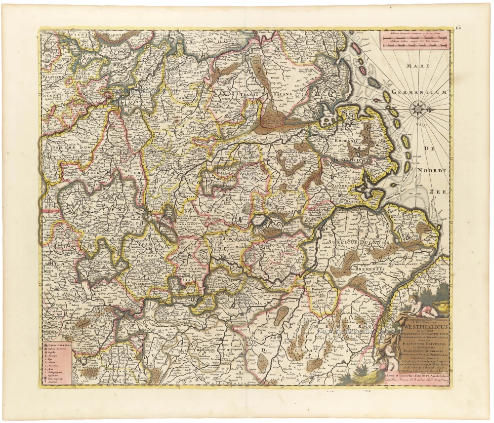
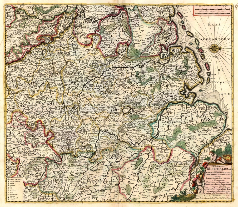
S.R.I. Circulus Westphalicus in quo sunt Episcopatus Monarsteriensis Paderbornensis et Osnabrugiensis, Ducatus Iuliasnensis, Clivensis, et Montensis, Principatus Mindensis, Ferdensis et Frisiae Orientalis, Comitatus Marchiae, Oldenburgi, Ravenspergae ...
Item Number: 33159 Authenticity Guarantee
Category: Antique maps > Europe > Germany
Rheinland-Westfalen & Nieder Sachsen, by F. De Wit.
Title: S.R.I. Circulus Westphalicus in quo sunt Episcopatus Monarsteriensis Paderbornensis et Osnabrugiensis, Ducatus Iuliasnensis, Clivensis, et Montensis, Principatus Mindensis, Ferdensis et Frisiae Orientalis, Comitatus Marchiae, Oldenburgi, Ravenspergae ...
Editore et Correctore F. De Witt. Amstelodami Cum Priv. Potent. D.D. Ordin. Holl. West-frisiaeq.
Oriented to the east.
Date of the first edition: c. 1697.
Date of this map: c. 1697-1704.
Copper engraving, printed on paper.
Image size: 470 x 540mm (18½ x 21¼ inches).
Sheet size: 535 x 630mm (21 x 24¾ inches).
Verso: Blank.
Condition: Original coloured, excellent.
Condition Rating: A.
From: Composite Atlas by F. De Wit, c. 1700.
Frederick de Wit (1630-1706)
The engraver and map-seller, Frederick de Wit, was born in Gouda (Netherlands) in 1630 as a son of Hendrick Fredericksz de Wit. Through his marriage with Maria van der Waag of Amsterdam in 1661, he obtained citizenship of the city where he had been working since 1648 and where he became one of the most famous engravers of maps of the second half of the 17th century. Although De Wit was a Catholic, which meant that he was not favoured at the time by the city council, he was awarded the honour of being listed as one of the "excellent citizens" on the roll of the city council in the years 1694-1704. However, his name was not written in the Guild of St. Luke book before 1664. At that time, he lived on the Kalverstraat "in de Witte Pascaert", where he stayed until his death in 1706. His earliest dates on maps engraved are 1659 (Regni Daniae) and 1660 (World map).
Frederick de Wit published several world atlases, a sea atlas, and an atlas of the Netherlands.
The dating of the maps is difficult. However, as a privilege was granted in 1689, the annotation 'cum privilegio' marks an edition after 1688.
Around 1700, Frederick de Wit entered the market with a town atlas. He produced two volumes with a total of 260 plans and views. Most were printed from plates used for Janssonius and Blaeu town atlases.
After he died in 1706, his widow continued the shop until 1709. The plates and stock of De Wit's atlas were sold to Covens & Mortier in 1710, who sold the atlas for an extended period.
Related items

[No title] 1636
Central Westfalen, by Gerard Mercator, published by Henricus Hondius.
[Item number: 7356]

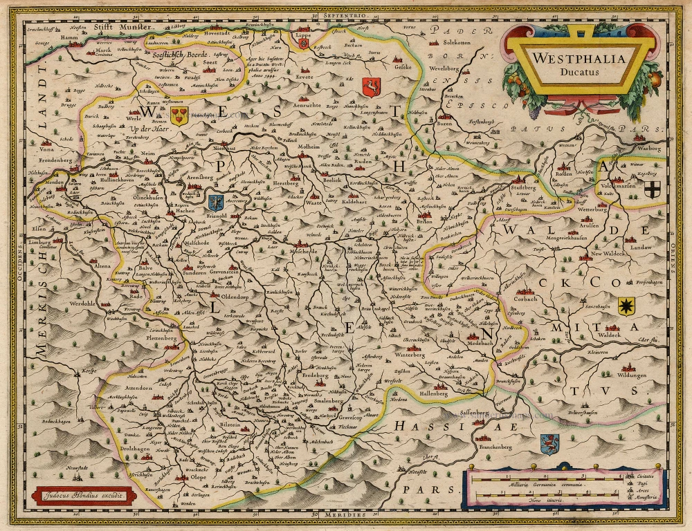
Westphalia Ducatus. 1662
Westfalen, by Blaeu W. & J.
[Item number: 9687]

Westphalia Ducatus 1636
Westfalen by Hondius-Janssonius.
[Item number: 9712]
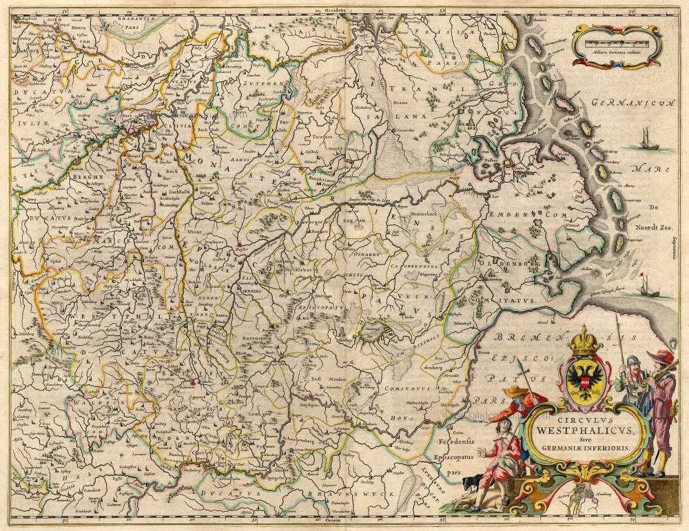
S.R.I. Circulus Westphalicus in quo sunt Episcopatus Monarsteriensis Paderbornensis et Osnabrugiensis, Ducatus Iuliasnensis, Clivensis, et Montensis, Principatus Mindensis, Ferdensis et Frisiae Orientalis, Comitatus Marchiae, Oldenburgi, Ravenspergae ... c. 1680
Rheinland-Westfalen & Nieder Sachsen, by F. De Wit.
[Item number: 10569]

No title. 1619
Westfalen (Central), by Gerard Mercator.
[Item number: 12586]

S.R.I. Westphaliae Circulus, in omnes ejusdem subjacentes Provincias. 1683-1696
Westfalen, by Visscher N. II.
[Item number: 18690]
Circulus Westphalicus sive Germaniae Inferioris 1642-43
Westfalen, by Blaeu W.
[Item number: 18715]
Westphalia Ducatus. 1630
Westfalen, by Hondius J.
[Item number: 18975]
Westphaliae totius, finitimarumque Regionum accurata descriptio. 1612
Westfalen by Ortelius A.
[Item number: 23000]

Westphaliae totius, finitimarumque Regionum accurata descriptio. 1612
Westfalen by Ortelius A.
[Item number: 23121]

Le Duché de Westphalie ainsi qu'il est presentement possedé par l'Eslecteur de Cologne 1710
Westphalia (Westfalen), by N. Sanson - Covens & Mortier.
[Item number: 23838]

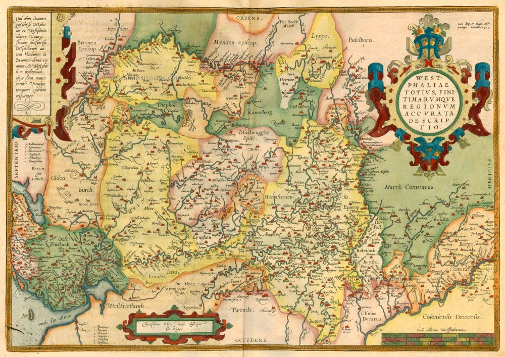
Westphaliae totius, finitimarumque Regionum accurata descriptio. 1579
Westfalen by Abraham Ortelius.
[Item number: 25319]
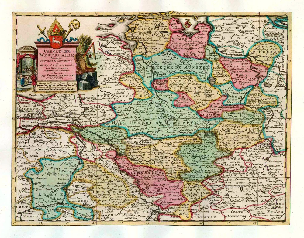
Cercle de Westphalie. 1713
Westfalen, by Pieter van der Aa.
[Item number: 26190]
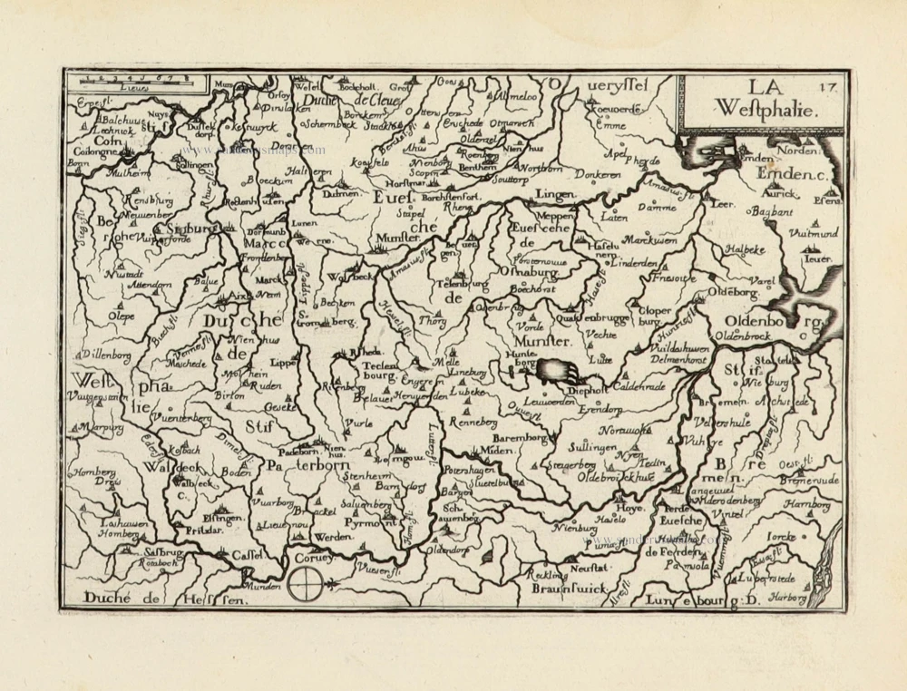
La Westphalie. 1633
Westfalen by C. Tassin.
[Item number: 31765]