
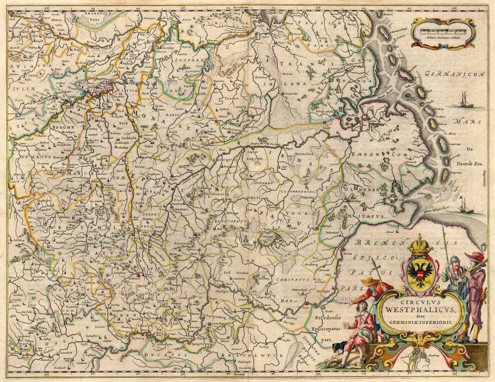
*** Extremely rare map of Westphalia, by Pieter Verbiest. *** 1624

EXTREMELY RARE MAP OF WESTPHALIA, BY PIETER VERBIEST
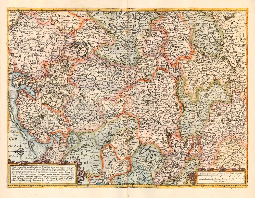
This map was the only map reissued by the Mercator heirs and put on the market in 1599. The current situation in the theatre of war prompted the publication. The Lower Rhine and the Northwest German regions also got drawn into the hostilities in the Revolt of the Northern Provinces against the Spanish Crown. In November 1598, Spanish commander Francisco de Mendoza crossed the Lower Rhine with an army. Even though they did not engage Prince Maurits in direct combat, the Spanish mercenary troops plundered and destroyed large areas on the right bank of the Rhine to Munster. The Mercator heirs responded to the current event and put a map on the market showing the area between the Rhine and the Weser. In so doing, they arrived at a cooperative arrangement with Amsterdam. There are some exemplars of this map on which the Latin title is covered by a strip of paper with Dutch text in letterpress. The Latin title and the Dutch variant name different persons as having contributed to the creation of the map. The Latin version identifies Gerard Mercator as the author. This might have been done in hommage to the great cartographer who had died in 1594. But it is much more plausible that his grandson Gerard II (c. 1563-1628) had compiled it from his grandfather's material. The map of Westphalia was composed with the aid of three Atlas maps from the 1585 instalment of his Atlas series. The Dutch title identifies Rumold Mercator as the printer of this map.
Pieter Verbiest II (Petrus Verbist) and Isaak Verbiest (Isack Verbist)
Pieter Verbiest (Antwerpen, 1605-1693) was an Antwerp cartographer and engraver. Little is known about his life.
One of his most important works is the Novus Tabularum Geographicorum Belgicae (Antwerp, 1636), a pocket atlas of which two more editions were published later (1644 and 1652). Isaak Verbiest, probably a brother of Pieter, drew and engraved certain maps. Their collaboration also led to the production of two rare world maps.
Pieter Verbiest also published folio maps as separate publications. Koeman describes three editions of a Verbiest Atlas of the Netherlands, published between 1636 and 1652. Only one copy of each of these atlases is known.
Verbiest maps, some with beautiful decorative borders, city views, costumed figures, and coats of arms, were sometimes bound in composite atlases. Occasionally, copies of these scarce maps come onto the market.
Pieter Verbiest II was the son of Pieter Verbiest I (c. 1585-c. 1642), publisher and illuminator of maps in Antwerp.
Tabula Geographica amplißimae ditionis Westphaliae conterminarumq provinciarium: delineata eo, quo Admirandus Arragoniae Potentißimi Hispaniar Regis Archistrategus, eam occupaverat, tempore. Continenturq haec tabella Ducatus Cliviae, Juliaci, Geldriae, Be
Currently not available
Item Number: 27741 Authenticity Guarantee
Category: Antique maps > Europe > Germany
Old, antique map of Westphalia, by Pieter Verbiest.
Alte, antike Karte von Westfalen, von Pieter Verbiest.
Third state.
Oriented to the east.
Cartographer: Rumold Mercator
Date of the first state: 1599 (R. Mercator), 2 recorded copies.
Date of the second state: 1604 (C. Claesz), 9 recorded copies.
Date of the third state (this map): 1624 (P. Verbiest), 1 recorded copy (Brussel, Kon. Bibl.).
Date of the fourth state: 1634 (P. Verbiest), 2 recorded copies.
Date on map: 1624
Copper engraving, printed on paper.
Size (not including margins): 40 x 53.5cm (15.6 x 20.9 inches)
Verso: Blank
Condition: Original coloured, excellent.
Condition Rating: A+
References: Schilder 7, #15.10 State 3 - Ill. 15.72.
Separate publication. From a composite atlas published c. 1630.
EXTREMELY RARE MAP OF WESTPHALIA, BY PIETER VERBIEST
This map was the only map reissued by the Mercator heirs and put on the market in 1599. The current situation in the theatre of war prompted the publication. The Lower Rhine and the Northwest German regions also got drawn into the hostilities in the Revolt of the Northern Provinces against the Spanish Crown. In November 1598, Spanish commander Francisco de Mendoza crossed the Lower Rhine with an army. Even though they did not engage Prince Maurits in direct combat, the Spanish mercenary troops plundered and destroyed large areas on the right bank of the Rhine to Munster. The Mercator heirs responded to the current event and put a map on the market showing the area between the Rhine and the Weser. In so doing, they arrived at a cooperative arrangement with Amsterdam. There are some exemplars of this map on which the Latin title is covered by a strip of paper with Dutch text in letterpress. The Latin title and the Dutch variant name different persons as having contributed to the creation of the map. The Latin version identifies Gerard Mercator as the author. This might have been done in hommage to the great cartographer who had died in 1594. But it is much more plausible that his grandson Gerard II (c. 1563-1628) had compiled it from his grandfather's material. The map of Westphalia was composed with the aid of three Atlas maps from the 1585 instalment of his Atlas series. The Dutch title identifies Rumold Mercator as the printer of this map.
Pieter Verbiest II (Petrus Verbist) and Isaak Verbiest (Isack Verbist)
Pieter Verbiest (Antwerpen, 1605-1693) was an Antwerp cartographer and engraver. Little is known about his life.
One of his most important works is the Novus Tabularum Geographicorum Belgicae (Antwerp, 1636), a pocket atlas of which two more editions were published later (1644 and 1652). Isaak Verbiest, probably a brother of Pieter, drew and engraved certain maps. Their collaboration also led to the production of two rare world maps.
Pieter Verbiest also published folio maps as separate publications. Koeman describes three editions of a Verbiest Atlas of the Netherlands, published between 1636 and 1652. Only one copy of each of these atlases is known.
Verbiest maps, some with beautiful decorative borders, city views, costumed figures, and coats of arms, were sometimes bound in composite atlases. Occasionally, copies of these scarce maps come onto the market.
Pieter Verbiest II was the son of Pieter Verbiest I (c. 1585-c. 1642), publisher and illuminator of maps in Antwerp.
Related items

Westphalia Ducatus. 1662
Westfalen, by Blaeu W. & J.
[Item number: 9687]

Westphalia Ducatus 1636
Westfalen by Hondius-Janssonius.
[Item number: 9712]
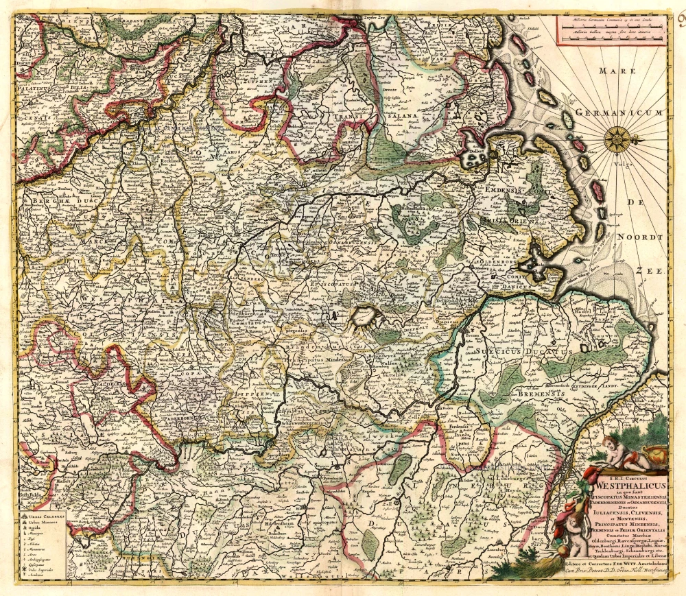
S.R.I. Circulus Westphalicus in quo sunt Episcopatus Monarsteriensis Paderbornensis et Osnabrugiensis, Ducatus Iuliasnensis, Clivensis, et Montensis, Principatus Mindensis, Ferdensis et Frisiae Orientalis, Comitatus Marchiae, Oldenburgi, Ravenspergae ... c. 1680
Rheinland-Westfalen & Nieder Sachsen, by F. De Wit.
[Item number: 10569]

No title. 1619
Westfalen (Central), by Gerard Mercator.
[Item number: 12586]

S.R.I. Westphaliae Circulus, in omnes ejusdem subjacentes Provincias. 1683-1696
Westfalen, by Visscher N. II.
[Item number: 18690]
Circulus Westphalicus sive Germaniae Inferioris 1642-43
Westfalen, by Blaeu W.
[Item number: 18715]
Westphalia Ducatus. 1630
Westfalen, by Hondius J.
[Item number: 18975]

Le Duché de Westphalie ainsi qu'il est presentement possedé par l'Eslecteur de Cologne 1710
Westphalia (Westfalen), by N. Sanson - Covens & Mortier.
[Item number: 23838]
Cercle de Westphalie. 1713
Westfalen, by Pieter van der Aa.
[Item number: 26190]

Archiepiscopatus Coloniensis; Ducatibus Iuliacensi et Montensi Intermedius: Queis in Septentrionem adjacent Geldria Hispanica, ac Comitatus Mursanus. c. 1680-1700
North Rhein-Westphalia, by Gerard Valk.
[Item number: 29659]