
Crete by Guillaume Sanson. 1676

SANSON FAMILY
Nicolas Sanson (1600-1667) - Guillaume Sanson (1633-1703) - Pierre Moullart-Sanson (? -1730)
Originally from Abbeville, Nicolas I Sanson showed a keen interest in historical geography. He was still very young; he published a map of ancient Gaul and two treatises, Britannia and Portus Itius on Abbeville and Boulogne's origins. His meeting with Melchior Tavernier was decisive: it prompted him to give up his duties as a military engineer in Picardy and devote himself to engraved cartography.
At the same time, Sanson had drawn up the outline of modern France. He got the help of Tavernier, who encouraged him to compete with the Dutch map publishers. Tavernier contacted other French cartographers whose works he published.
From 1643, N. Sanson obtained a privilege to publish a work personally, the Princes souverains de l'Italie. Then, in 1644 and 1645, he had his famous geographical tables printed, which significantly contributed to his fame. He also published a series of atlases in quarto of the four continents.
In 1648, N. Sanson associated himself with Mariette to publish atlases. From then on, specific maps bore his name and others Mariette's. N. Sanson and Mariette worked together for more than 20 years. After the death of N. Sanson, Mariette acquired the entire fund. Since Mariette only wanted to publish complete atlases, individual maps were no longer sold, and some army generals complained to the king.
The disagreement between the Sanson family and Pierre II Mariette culminated in 1671 when Guillaume Sanson took the case to court. There was no longer any question of collaboration: Guillaume Sanson started working for another publisher, Alexis-Hubert Jaillot.
The Sanson family faced financial difficulties, and in 1692, their cousin, Pierre Moullart-Sanson, bought the entire geographic fund from his uncles and aunt. Pierre Moullart-Sanson was the son of Françoise Sanson (third child of Nicolas) and Pierre Moullart. He restarted the publishing of Sanson's world atlas, and in 1704 he acquired a privilege for publishing all the works of Nicolas and Guillaume Sanson, which continued to be published until 1730.
Creta Insula Olerumq: Deum Natalibus, Iovis Incunabulis, Sepulchroq: Inclyta: ...
Item Number: 28522 Authenticity Guarantee
Category: Antique maps > Europe > Greece & Greek Islands
Old, antique map of Crete, by Guillaume Sanson.
RARE!
Title: Creta Insula Olerumq: Deum Natalibus, Iovis Incunabulis, Sepulchroq: Inclyta: ...
Conatibys Geographicis Gulielmi Sanson Nicolai Filii. MDCLXXVI.
Lutetiae Parisiorum Apud Autorem Cum Privilegio ad 20 Annos.
Date of the first edition: 1676.
Date of this map: 1676.
Date on map: 1676.
Copper engraving, printed on paper.
Map size: 390 x 540mm (15.35 x 21.26 inches).
Sheet size: 445 x 610mm (17.52 x 24.02 inches).
Verso: Blank.
Condition: Backed with paper.
Condition Rating: A.
References: Zacharakis, 3168/2691
From: Cartes et Tables de la Geographie Ancienne et Nouvelle ou Methode pour s'Instruire Avec facilite de la Geographie, et Connoistre des Empires, Monarchies, Royaumes, Estats, Republiques, et Peuples ... Par les Srs. Sanson, Geographes du Roy ... A Paris. Chez l'Autheur ... 1697. (With maps dated until 1709).
SANSON FAMILY
Nicolas Sanson (1600-1667) - Guillaume Sanson (1633-1703) - Pierre Moullart-Sanson (? -1730)
Originally from Abbeville, Nicolas I Sanson showed a keen interest in historical geography. He was still very young; he published a map of ancient Gaul and two treatises, Britannia and Portus Itius on Abbeville and Boulogne's origins. His meeting with Melchior Tavernier was decisive: it prompted him to give up his duties as a military engineer in Picardy and devote himself to engraved cartography.
At the same time, Sanson had drawn up the outline of modern France. He got the help of Tavernier, who encouraged him to compete with the Dutch map publishers. Tavernier contacted other French cartographers whose works he published.
From 1643, N. Sanson obtained a privilege to publish a work personally, the Princes souverains de l'Italie. Then, in 1644 and 1645, he had his famous geographical tables printed, which significantly contributed to his fame. He also published a series of atlases in quarto of the four continents.
In 1648, N. Sanson associated himself with Mariette to publish atlases. From then on, specific maps bore his name and others Mariette's. N. Sanson and Mariette worked together for more than 20 years. After the death of N. Sanson, Mariette acquired the entire fund. Since Mariette only wanted to publish complete atlases, individual maps were no longer sold, and some army generals complained to the king.
The disagreement between the Sanson family and Pierre II Mariette culminated in 1671 when Guillaume Sanson took the case to court. There was no longer any question of collaboration: Guillaume Sanson started working for another publisher, Alexis-Hubert Jaillot.
The Sanson family faced financial difficulties, and in 1692, their cousin, Pierre Moullart-Sanson, bought the entire geographic fund from his uncles and aunt. Pierre Moullart-Sanson was the son of Françoise Sanson (third child of Nicolas) and Pierre Moullart. He restarted the publishing of Sanson's world atlas, and in 1704 he acquired a privilege for publishing all the works of Nicolas and Guillaume Sanson, which continued to be published until 1730.
Related items

Creta Iovis magni, medio iacet insula ponto. Ex conatibus geographicis Abrahami Ortelij. [On sheet with:] Corsica [and:] Insulae Maris Ionii [and:] Sardinia 1624
Crete, Corsica and Sardinia by Ortelius A.
[Item number: 2052]

Cyprus Insula - Candia, olim Creta. 1572
Cyprus - Crete, by A. Ortelius.
[Item number: 16585]
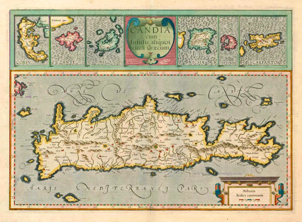
Candia cum insulis aliquot circa Graeciam. 1623
Crete with the isles of Corfu, Zante, Milo, Nicsia, Santorini and Scarpanto by Gerard Mercator.
[Item number: 20541]

Candia Insula [on sheet with] Archipelagi Insularum aliquot descrip. 1612
Crete and 10 Aegean islands, by Abraham Ortelius.
[Item number: 22976]
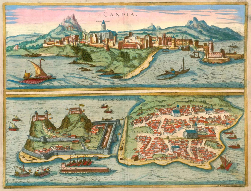
Candia [on sheet with] La Cita de Corphu 1597
Crete (Iraklion) & Corfu, by Georg Braun and Frans Hogenberg.
[Item number: 23289]

Candia [on sheet with] La Cita de Corphu 1575-1612
Crete - Heraklion (Irákleio) & Corfu (Kérkyra), by Georg Braun and Frans Hogenberg.
[Item number: 24007]

Candia vel Creta insula posta nel mare Mediterraneo ... After 1575
Crete (Creta) by Giovanni Francesco Camocio
[Item number: 27579]

Candia [on sheet with:] Corphu. 1638
Crete - Corfu, by Matthäus Merian.
[Item number: 27982]

Tabula nova Candiae. 1541
Crete, by Lorenz Fries
[Item number: 28127]

First edition
Creta Iovis magni, medio iacet insula ponto. [On sheet with:] Corsica [and:] Insulae Maris Ionii [and:] Sardinia. 1584
Corsica, Crete (Creta), Sardinia, by Abraham Ortelius.
[Item number: 29148]

Candia - [Above map :] Descrittione del l'Isola di Candia. 1590
Crete by Thomasso Porcacchi.
[Item number: 29838]

Candia [on sheet with] La Cita de Corphu. 1657
Crete (Iraklion) & Corfu, by Georg Braun and Frans Hogenberg, published by J. Janssonius.
[Item number: 31080]
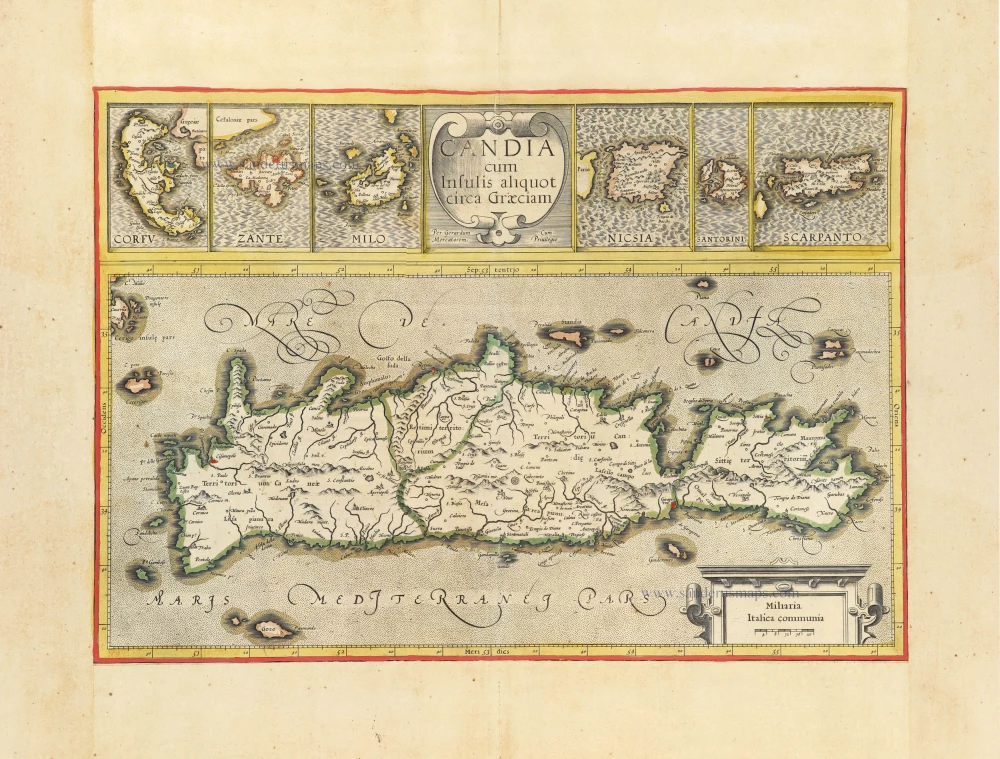
Candia cum insulis aliquot circa Graeciam. c. 1610-1650
Crete and Mediterranean Islands, by Gerard Mercator.
[Item number: 31324]

Retimo in Candia. c. 1690
Rethymno (Crete) by J. Peeters, published by Gaspar Huberti.
[Item number: 31366]

Porta Suda Paleo in Candia. c. 1690
Souda (Crete) by J. Peeters.
[Item number: 31367]

Canea in Candia. c. 1690
Chania (Crete) by J. Peeters.
[Item number: 31377]

La Citta di Candia. c. 1690
Irakleio (Crete) by J. Peeters.
[Item number: 31378]

Candia 1618
Crete by Petrus Bertius, published by Jodocus Hondius II.
[Item number: 31848]