
Pozzuoli - Baia, by Braun & Hogenberg. 1575

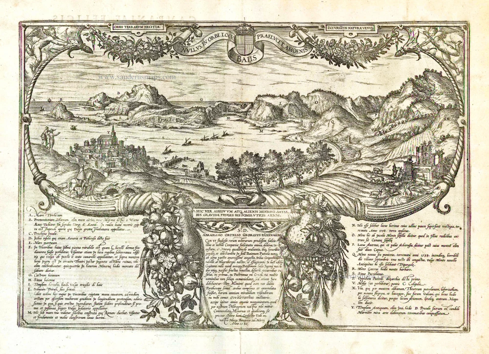
COMMENTARY BY BRAUN: "Next to Pozzuoli, enormous columns rising out of the sea can be observed, on top of which several crumbling arches still rest. Similar columns can also be seen in the water on the other side near Baia. Emperor Caligula erected a bridge here from one location to the other, as Sueton attests. Caligula had conceived of a new and entirely unheard-of miracle, namely, of connecting the two locations of Pozzuoli and Baia, situated 6,300 paces apart, with a bridge. For this, he had all large ships brought over and anchored together so that he could walk over them as if on the Via Appia."
Both plates of Pozzuoli and Baia belong together thematically. Both towns in the Gulf of Naples have Greek origins. Pozzuoli was founded as Dikaiacheia in 531 BC; from 194 BC, it carried the name Puteoli. Baia was the harbour of the ancient city of Cumae, founded by the Greeks. Pozzuoli was one of the most important Roman ports; in AD 39, Caligula supposedly erected a bridge of ships from Pozzuoli to Baia to refute a prophecy claiming that he only had a chance of becoming emperor if he rode a horse to Baia over the Gulf. Baia was already known during Roman times for its springs and was revered as a healing bath; the remains of ancient thermal baths are found here. Both perspectives are enlivened by the animated depiction of the Gulf of Naples. (Taschen)
Braun G. & Hogenberg F. and the Civitates Orbis Terrarum.
The Civitates Orbis Terrarum, also known as the 'Braun & Hogenberg', is a six-volume town atlas and the most excellent book of town views and plans ever published: 363 engravings, sometimes beautifully coloured. It was one of the best-selling works in the last quarter of the 16th century. Georg Braun, a skilled writer, wrote the text accompanying the plans and views on the verso. Many plates were engraved after the original drawings of a professional artist, Joris Hoefnagel (1542-1600). The first volume was published in Latin in 1572 and the sixth in 1617. Frans Hogenberg, a talented engraver, created the tables for volumes I through IV, and Simon van den Neuwel made those for volumes V and VI. Other contributors were cartographers Daniel Freese and Heinrich Rantzau, who provided valuable geographical information. Works by Jacob van Deventer, Sebastian Münster, and Johannes Stumpf were also used as references. Translations appeared in German and French, making the atlas accessible to a broader audience.
Since its original publication of volume 1 in 1572, the Civitates Orbis Terrarum has left an indelible mark on the history of cartography. Seven more editions followed the first volume in 1575, 1577, 1582, 1588, 1593, 1599, and 1612. Vol.2, initially released in 1575, saw subsequent editions in 1597 and 1612. The subsequent volumes, each a treasure trove of historical insights, graced the world in 1581, 1588, 1593, 1599, and 1606. The German translation of the first volume, a testament to its widespread appeal, debuted in 1574, followed by the French edition in 1575.
Several printers were involved: Theodor Graminaeus, Heinrich von Aich, Gottfried von Kempen, Johannis Sinniger, Bertram Buchholtz, and Peter von Brachel, all of whom worked in Cologne.
Georg Braun (1541-1622)
Georg Braun, the author of the text accompanying the plans and views in the Civitates Orbis Terrarum, was born in Cologne in 1541. After his studies in Cologne, he entered the Jesuit Order as a novice, indicating his commitment to learning and intellectual pursuits. In 1561, he obtained his bachelor's degree; in 1562, he received his Magister Artium, further demonstrating his academic achievements. Although he left the Jesuit Order, he continued his studies in theology, gaining a licentiate in theology. His theological background likely influenced the content and tone of the text in the Civitates Orbis Terrarum, adding a unique perspective to the work.
Frans Hogenberg (1535-1590)
Frans Hogenberg was a Flemish and German painter, engraver, and mapmaker. He was born in Mechelen as the son of Nicolaas Hogenberg.
By the end of the 1560s, Frans Hogenberg was employed upon Abraham Ortelius's Theatrum Orbis Terrarum, published in 1570; he is named an engraver of numerous maps. In 1568, he was banned from Antwerp by the Duke of Alva and travelled to London, where he stayed a few years before emigrating to Cologne. He immediately embarked on his two most important works, the Civitates, published in 1572 and the Geschichtsblätter, which appeared in several series from 1569 until about 1587.
Thanks to large-scale projects like the Geschichtsblätter and the Civitates, Hogenberg's social circumstances improved with each passing year. He died as a wealthy man in Cologne in 1590.
Puteoli - Baiae
Item Number: 17963 Authenticity Guarantee
Category: Antique maps > Europe > Italy - Cities
Antique map of Pozzuoli - Baia by Braun & Hogenberg.
Title: Puteoli - Baiae
Date of the first edition: 1575.
Date of this map: 1575.
Copper engraving, printed on paper.
Size (not including margins): 290 x 490mm (11.42 x 19.29 inches).
Verso: Latin text.
Condition: Original coloured, slight browning at centrefold.
Condition Rating: A.
From: Civitates Orbis Terrarum, ... Part 2: De Praecipuis, Totius Universi Urbibus, Liber Secundus. Köln, Gottfried von Kempen, 1575. (Van der Krogt 4, 41:1.2)
COMMENTARY BY BRAUN: "Next to Pozzuoli, enormous columns rising out of the sea can be observed, on top of which several crumbling arches still rest. Similar columns can also be seen in the water on the other side near Baia. Emperor Caligula erected a bridge here from one location to the other, as Sueton attests. Caligula had conceived of a new and entirely unheard-of miracle, namely, of connecting the two locations of Pozzuoli and Baia, situated 6,300 paces apart, with a bridge. For this, he had all large ships brought over and anchored together so that he could walk over them as if on the Via Appia."
Both plates of Pozzuoli and Baia belong together thematically. Both towns in the Gulf of Naples have Greek origins. Pozzuoli was founded as Dikaiacheia in 531 BC; from 194 BC, it carried the name Puteoli. Baia was the harbour of the ancient city of Cumae, founded by the Greeks. Pozzuoli was one of the most important Roman ports; in AD 39, Caligula supposedly erected a bridge of ships from Pozzuoli to Baia to refute a prophecy claiming that he only had a chance of becoming emperor if he rode a horse to Baia over the Gulf. Baia was already known during Roman times for its springs and was revered as a healing bath; the remains of ancient thermal baths are found here. Both perspectives are enlivened by the animated depiction of the Gulf of Naples. (Taschen)
Braun G. & Hogenberg F. and the Civitates Orbis Terrarum.
The Civitates Orbis Terrarum, also known as the 'Braun & Hogenberg', is a six-volume town atlas and the most excellent book of town views and plans ever published: 363 engravings, sometimes beautifully coloured. It was one of the best-selling works in the last quarter of the 16th century. Georg Braun, a skilled writer, wrote the text accompanying the plans and views on the verso. Many plates were engraved after the original drawings of a professional artist, Joris Hoefnagel (1542-1600). The first volume was published in Latin in 1572 and the sixth in 1617. Frans Hogenberg, a talented engraver, created the tables for volumes I through IV, and Simon van den Neuwel made those for volumes V and VI. Other contributors were cartographers Daniel Freese and Heinrich Rantzau, who provided valuable geographical information. Works by Jacob van Deventer, Sebastian Münster, and Johannes Stumpf were also used as references. Translations appeared in German and French, making the atlas accessible to a broader audience.
Since its original publication of volume 1 in 1572, the Civitates Orbis Terrarum has left an indelible mark on the history of cartography. Seven more editions followed the first volume in 1575, 1577, 1582, 1588, 1593, 1599, and 1612. Vol.2, initially released in 1575, saw subsequent editions in 1597 and 1612. The subsequent volumes, each a treasure trove of historical insights, graced the world in 1581, 1588, 1593, 1599, and 1606. The German translation of the first volume, a testament to its widespread appeal, debuted in 1574, followed by the French edition in 1575.
Several printers were involved: Theodor Graminaeus, Heinrich von Aich, Gottfried von Kempen, Johannis Sinniger, Bertram Buchholtz, and Peter von Brachel, all of whom worked in Cologne.
Georg Braun (1541-1622)
Georg Braun, the author of the text accompanying the plans and views in the Civitates Orbis Terrarum, was born in Cologne in 1541. After his studies in Cologne, he entered the Jesuit Order as a novice, indicating his commitment to learning and intellectual pursuits. In 1561, he obtained his bachelor's degree; in 1562, he received his Magister Artium, further demonstrating his academic achievements. Although he left the Jesuit Order, he continued his studies in theology, gaining a licentiate in theology. His theological background likely influenced the content and tone of the text in the Civitates Orbis Terrarum, adding a unique perspective to the work.
Frans Hogenberg (1535-1590)
Frans Hogenberg was a Flemish and German painter, engraver, and mapmaker. He was born in Mechelen as the son of Nicolaas Hogenberg.
By the end of the 1560s, Frans Hogenberg was employed upon Abraham Ortelius's Theatrum Orbis Terrarum, published in 1570; he is named an engraver of numerous maps. In 1568, he was banned from Antwerp by the Duke of Alva and travelled to London, where he stayed a few years before emigrating to Cologne. He immediately embarked on his two most important works, the Civitates, published in 1572 and the Geschichtsblätter, which appeared in several series from 1569 until about 1587.
Thanks to large-scale projects like the Geschichtsblätter and the Civitates, Hogenberg's social circumstances improved with each passing year. He died as a wealthy man in Cologne in 1590.
Related items

Calatia vulgo Caiazo, perantiquum Campaniae foelicis oppidum. 1596
Caiazzo, by Braun & Hogenberg.
[Item number: 22118]

Novara Mediolanensis Ducatus Civitas c. 1625
Novara by Braun and Hogenberg.
[Item number: 24530]
Nullus in Orbe Locus Baiis Praelucet Amoenis. 1616
Pozzuoli, by Braun Georg & Hogenberg Frans.
[Item number: 26912]