Genua and Florence by Georg Braun & Frans Hogenberg 1577
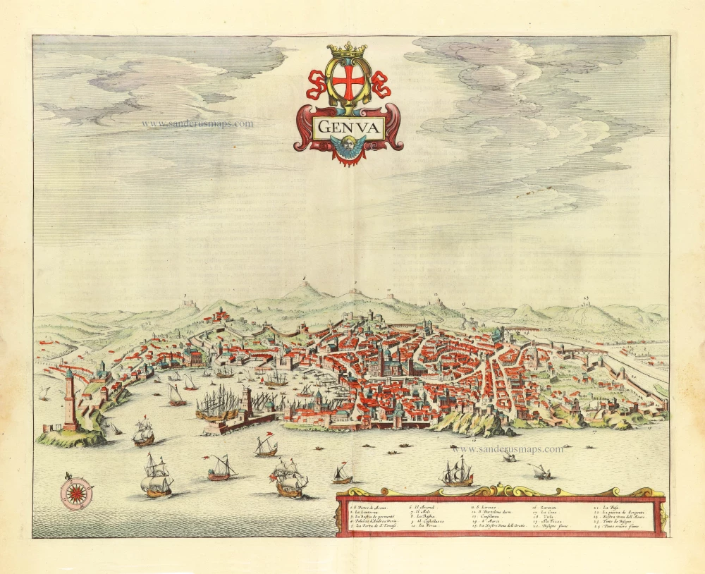
GENOA (GENOVA):
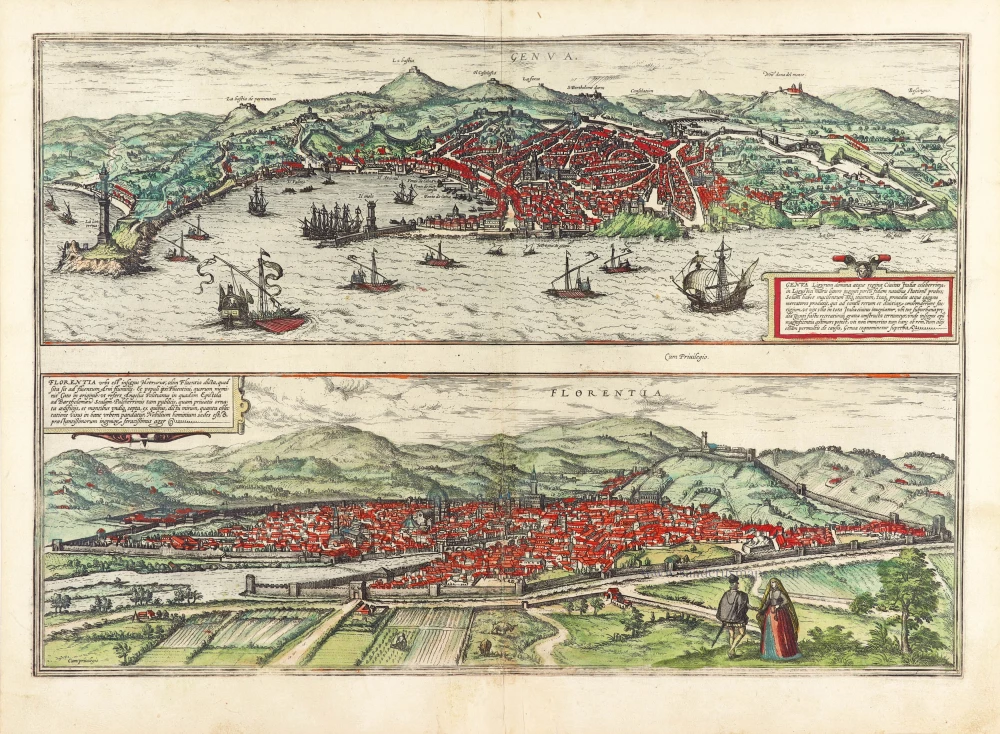
TRANSLATION OF CARTOUCHE TEXT: Genoa, mistress and queen of Liguria, an illustrious city in Italy, provides a safe anchorage for ships with her huge harbour on the coast of the Ligurian Sea. The city has poor and barren soil, a fact that has produced shrewd and prudent merchants. These latter have raised it to such prosperity in goods and wealth that in all Italy, there is barely another city before whose gates lie so many country estates, built purely for leisure and with incredible pride. It can be judged from this that the Genoese parade their wealth ostentatiously: not without reason does the city [...] bear the epithet "the proud".
COMMENTARY BY BRAUN: "Genoa, the capital of Liguria, is a powerful, proud and very ancient city. [...] It has an extremely well-fortified and safe harbour and is famous for its honest merchants. In all periods, it has produced excellent merchants who deal with water and land in all things. [...] It recognizes the King of Spain as its supreme lord and is ruled by a duke appointed afresh every year."
The trading port and city of Genova are presented from an ideal, elevated viewpoint from the south. The city's layout can be clearly seen as it slopes down to the sea. In the centre stands the Romanesque cathedral of San Lorenzo, built in the 13th century. Higher up the hillside lies the Palazzo Ducale, here still a medieval complex from the 13th century. The approximately 80-m-high lighthouse (La Lanterna) on the left is another symbol of the city. Genoa's economic importance is underlined by the volume of shipping in front of the port; the New World was discovered in 1492 by the Genoa-born Columbus. 1407 saw the founding in Genoa of the Banco di San Giorgio, which lent money to various monarchs in the early modern era and thereby earned Genoa an exceptionally important position within the network of Europe's ruling houses.
FLORENCE (FIRENZE):
CARTOUCHE: Florence is a distinguished city in Etruria, formerly called Fluentia because it lies on the stream of the River Arno. [...] Embellished with beautiful public and private buildings and surrounded by hills on all sides, Florence is the residence of famous men and a fertile field for outstanding talents.
COMMENTARY BY BRAUN: "For just as Venice is called the rich, Milan the great, Genoa the proud, Bologna the fertile, Ravenna the ancient, Naples the noble and Rome the holy city, Florence is called the beautiful. It has magnificent churches, of which Santa Maria del Fiore is particularly wonderful: it is built of marble and beside it stands a tower, also of marble, quite magnificently furnished with bells."
The engraving shows Florence from the southwest. On the far side of the Arno, the cathedral of Santa Maria del Fiore, with its impressive cupola (1418-1436) by Filippo Brunelleschi, soars above the roofs of the densely packed houses. Visible in front of it is the bell tower, built from 1330 to designs by Giotto, and the Baptistery (11th-12th century) with its magnificent bronze doors by Andrea Pisano and Lorenzo Ghiberti (1330-1452). Behind it to the right, as a symbol of secular power, is the Palazzo della Signoria (14th cent.), today known as the Palazzo Vecchio, with its 94-m-high tower. Florence was founded as a Roman colony in Caesar's day when it marked the intersection of two major trade routes. In the 14th and 15th centuries, it developed into a city of art and culture, attracting many artists and intellectuals, including Sandro Botticelli, Galileo Galilei, Leonardo de Vinci and Niccolo Machiavelli. Under the rule of the Medici family, Florence also developed into an important centre of finance and trade. With a population of around 366,000, Florence is today the capital of Tuscany. (Taschen)
Braun G. & Hogenberg F. and the Civitates Orbis Terrarum.
The Civitates Orbis Terrarum, also known as the 'Braun & Hogenberg', is a six-volume town atlas and the most excellent book of town views and plans ever published: 363 engravings, sometimes beautifully coloured. It was one of the best-selling works in the last quarter of the 16th century. Georg Braun, a skilled writer, wrote the text accompanying the plans and views on the verso. Many plates were engraved after the original drawings of a professional artist, Joris Hoefnagel (1542-1600). The first volume was published in Latin in 1572 and the sixth in 1617. Frans Hogenberg, a talented engraver, created the tables for volumes I through IV, and Simon van den Neuwel made those for volumes V and VI. Other contributors were cartographers Daniel Freese and Heinrich Rantzau, who provided valuable geographical information. Works by Jacob van Deventer, Sebastian Münster, and Johannes Stumpf were also used as references. Translations appeared in German and French, making the atlas accessible to a broader audience.
Since its original publication of volume 1 in 1572, the Civitates Orbis Terrarum has left an indelible mark on the history of cartography. Seven more editions followed the first volume in 1575, 1577, 1582, 1588, 1593, 1599, and 1612. Vol.2, initially released in 1575, saw subsequent editions in 1597 and 1612. The subsequent volumes, each a treasure trove of historical insights, graced the world in 1581, 1588, 1593, 1599, and 1606. The German translation of the first volume, a testament to its widespread appeal, debuted in 1574, followed by the French edition in 1575.
Several printers were involved: Theodor Graminaeus, Heinrich von Aich, Gottfried von Kempen, Johannis Sinniger, Bertram Buchholtz, and Peter von Brachel, all of whom worked in Cologne.
Georg Braun (1541-1622)
Georg Braun, the author of the text accompanying the plans and views in the Civitates Orbis Terrarum, was born in Cologne in 1541. After his studies in Cologne, he entered the Jesuit Order as a novice, indicating his commitment to learning and intellectual pursuits. In 1561, he obtained his bachelor's degree; in 1562, he received his Magister Artium, further demonstrating his academic achievements. Although he left the Jesuit Order, he continued his studies in theology, gaining a licentiate in theology. His theological background likely influenced the content and tone of the text in the Civitates Orbis Terrarum, adding a unique perspective to the work.
Frans Hogenberg (1535-1590)
Frans Hogenberg was a Flemish and German painter, engraver, and mapmaker. He was born in Mechelen as the son of Nicolaas Hogenberg.
By the end of the 1560s, Frans Hogenberg was employed upon Abraham Ortelius's Theatrum Orbis Terrarum, published in 1570; he is named an engraver of numerous maps. In 1568, he was banned from Antwerp by the Duke of Alva and travelled to London, where he stayed a few years before emigrating to Cologne. He immediately embarked on his two most important works, the Civitates, published in 1572 and the Geschichtsblätter, which appeared in several series from 1569 until about 1587.
Thanks to large-scale projects like the Geschichtsblätter and the Civitates, Hogenberg's social circumstances improved with each passing year. He died as a wealthy man in Cologne in 1590.
Genua Ligurum Domina [on sheet with] Florentia Urbs est Insignis Hetruariae, olim Fluentia Dicta.
Item Number: 29978 Authenticity Guarantee
Category: Antique maps > Europe > Italy - Cities
Old, antique bird’s-eye view plan of Genua and Florence by Georg Braun & Frans Hogenberg.
Title: Genua Ligurum Domina [on sheet with] Florentia Urbs est Insignis Hetruariae, olim Fluentia Dicta.
Cum privilegio.
Date of the first edition: 1572.
Date of this map: 1577.
Copper engraving, printed on paper.
Image size: 330 x 480mm (12.99 x 18.9 inches).
Sheet size: 380 x 515mm (14.96 x 20.28 inches).
Verso: Latin text.
Condition: Original coloured, excellent.
Condition Rating: A+.
From: Civitates Orbis Terrarum, Liber Primus. Köln, Gottfried von Kempen, 1577. (Van der Krogt 4, 41:1.1)
GENOA (GENOVA):
TRANSLATION OF CARTOUCHE TEXT: Genoa, mistress and queen of Liguria, an illustrious city in Italy, provides a safe anchorage for ships with her huge harbour on the coast of the Ligurian Sea. The city has poor and barren soil, a fact that has produced shrewd and prudent merchants. These latter have raised it to such prosperity in goods and wealth that in all Italy, there is barely another city before whose gates lie so many country estates, built purely for leisure and with incredible pride. It can be judged from this that the Genoese parade their wealth ostentatiously: not without reason does the city [...] bear the epithet "the proud".
COMMENTARY BY BRAUN: "Genoa, the capital of Liguria, is a powerful, proud and very ancient city. [...] It has an extremely well-fortified and safe harbour and is famous for its honest merchants. In all periods, it has produced excellent merchants who deal with water and land in all things. [...] It recognizes the King of Spain as its supreme lord and is ruled by a duke appointed afresh every year."
The trading port and city of Genova are presented from an ideal, elevated viewpoint from the south. The city's layout can be clearly seen as it slopes down to the sea. In the centre stands the Romanesque cathedral of San Lorenzo, built in the 13th century. Higher up the hillside lies the Palazzo Ducale, here still a medieval complex from the 13th century. The approximately 80-m-high lighthouse (La Lanterna) on the left is another symbol of the city. Genoa's economic importance is underlined by the volume of shipping in front of the port; the New World was discovered in 1492 by the Genoa-born Columbus. 1407 saw the founding in Genoa of the Banco di San Giorgio, which lent money to various monarchs in the early modern era and thereby earned Genoa an exceptionally important position within the network of Europe's ruling houses.
FLORENCE (FIRENZE):
CARTOUCHE: Florence is a distinguished city in Etruria, formerly called Fluentia because it lies on the stream of the River Arno. [...] Embellished with beautiful public and private buildings and surrounded by hills on all sides, Florence is the residence of famous men and a fertile field for outstanding talents.
COMMENTARY BY BRAUN: "For just as Venice is called the rich, Milan the great, Genoa the proud, Bologna the fertile, Ravenna the ancient, Naples the noble and Rome the holy city, Florence is called the beautiful. It has magnificent churches, of which Santa Maria del Fiore is particularly wonderful: it is built of marble and beside it stands a tower, also of marble, quite magnificently furnished with bells."
The engraving shows Florence from the southwest. On the far side of the Arno, the cathedral of Santa Maria del Fiore, with its impressive cupola (1418-1436) by Filippo Brunelleschi, soars above the roofs of the densely packed houses. Visible in front of it is the bell tower, built from 1330 to designs by Giotto, and the Baptistery (11th-12th century) with its magnificent bronze doors by Andrea Pisano and Lorenzo Ghiberti (1330-1452). Behind it to the right, as a symbol of secular power, is the Palazzo della Signoria (14th cent.), today known as the Palazzo Vecchio, with its 94-m-high tower. Florence was founded as a Roman colony in Caesar's day when it marked the intersection of two major trade routes. In the 14th and 15th centuries, it developed into a city of art and culture, attracting many artists and intellectuals, including Sandro Botticelli, Galileo Galilei, Leonardo de Vinci and Niccolo Machiavelli. Under the rule of the Medici family, Florence also developed into an important centre of finance and trade. With a population of around 366,000, Florence is today the capital of Tuscany. (Taschen)
Braun G. & Hogenberg F. and the Civitates Orbis Terrarum.
The Civitates Orbis Terrarum, also known as the 'Braun & Hogenberg', is a six-volume town atlas and the most excellent book of town views and plans ever published: 363 engravings, sometimes beautifully coloured. It was one of the best-selling works in the last quarter of the 16th century. Georg Braun, a skilled writer, wrote the text accompanying the plans and views on the verso. Many plates were engraved after the original drawings of a professional artist, Joris Hoefnagel (1542-1600). The first volume was published in Latin in 1572 and the sixth in 1617. Frans Hogenberg, a talented engraver, created the tables for volumes I through IV, and Simon van den Neuwel made those for volumes V and VI. Other contributors were cartographers Daniel Freese and Heinrich Rantzau, who provided valuable geographical information. Works by Jacob van Deventer, Sebastian Münster, and Johannes Stumpf were also used as references. Translations appeared in German and French, making the atlas accessible to a broader audience.
Since its original publication of volume 1 in 1572, the Civitates Orbis Terrarum has left an indelible mark on the history of cartography. Seven more editions followed the first volume in 1575, 1577, 1582, 1588, 1593, 1599, and 1612. Vol.2, initially released in 1575, saw subsequent editions in 1597 and 1612. The subsequent volumes, each a treasure trove of historical insights, graced the world in 1581, 1588, 1593, 1599, and 1606. The German translation of the first volume, a testament to its widespread appeal, debuted in 1574, followed by the French edition in 1575.
Several printers were involved: Theodor Graminaeus, Heinrich von Aich, Gottfried von Kempen, Johannis Sinniger, Bertram Buchholtz, and Peter von Brachel, all of whom worked in Cologne.
Georg Braun (1541-1622)
Georg Braun, the author of the text accompanying the plans and views in the Civitates Orbis Terrarum, was born in Cologne in 1541. After his studies in Cologne, he entered the Jesuit Order as a novice, indicating his commitment to learning and intellectual pursuits. In 1561, he obtained his bachelor's degree; in 1562, he received his Magister Artium, further demonstrating his academic achievements. Although he left the Jesuit Order, he continued his studies in theology, gaining a licentiate in theology. His theological background likely influenced the content and tone of the text in the Civitates Orbis Terrarum, adding a unique perspective to the work.
Frans Hogenberg (1535-1590)
Frans Hogenberg was a Flemish and German painter, engraver, and mapmaker. He was born in Mechelen as the son of Nicolaas Hogenberg.
By the end of the 1560s, Frans Hogenberg was employed upon Abraham Ortelius's Theatrum Orbis Terrarum, published in 1570; he is named an engraver of numerous maps. In 1568, he was banned from Antwerp by the Duke of Alva and travelled to London, where he stayed a few years before emigrating to Cologne. He immediately embarked on his two most important works, the Civitates, published in 1572 and the Geschichtsblätter, which appeared in several series from 1569 until about 1587.
Thanks to large-scale projects like the Geschichtsblätter and the Civitates, Hogenberg's social circumstances improved with each passing year. He died as a wealthy man in Cologne in 1590.

