
Naples (Napoli) by Georg Braun & Frans Hogenberg 1612
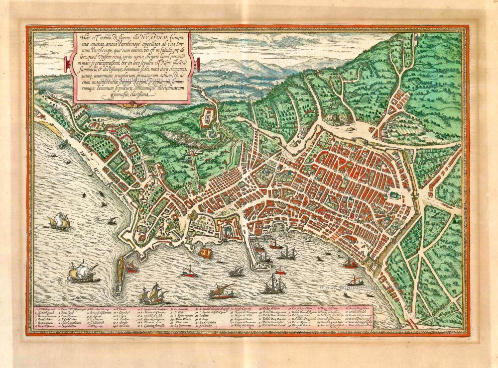


TRANSLATION CARTOUCHE: This is the notable and flourishing city of Naples in Campania, formerly called Parthenope, after Parthenope the siren, who was buried in this place. As legend relates, the sirens cast themselves into the sea in fury after they had been unable to seduce Odysseus and his companions with their song. Naples, today the residence of illustrious families and most learned men, is distinguished for the wonderful mildness of its air and its delightful location, the magnificence of its churches, private houses and palaces, beautiful tombs of kings, queens and high-ranking persons, and a university with all the faculties.
COMMENTARY BY BRAUN: "The fertile region around Naples [...] was the reason that the Romans liked to go to Naples after their work to rest and relax and to seek entertainment. This is where, amongst others, the most excellent poet Virgil lived, who wrote his Georgica book on agriculture here, so Servius says. Livy, Horace, Claudianus, Francesco Petrarch, Lorenzo Valla, Flavio Biondo and many others also lived here. [...] The streets are clean and straight. The strongest fortress in Naples is the Castel Nuovo, which may be rightly considered the safest castle in all Europe."
Naples is presented from a plan-like bird's-eye view. The dominant impression is of a bustling city and trading port with a well-designed layout and impregnable citadel. Naples saw its greatest flowering in the early modern era under Alfonso V of Aragon, who as Alfonso I was also king of Naples and Sicily. Between 1450 and 1550 it grew from 40,000 to 210,000 inhabitants and thereby became Europe's second-largest city after Paris. Noteworthy here are the three forts: the Castel Nuovo (10) lies directly on the seafront beside the large mole. On the rocky promontory on the left, the Castel dell'Ovo (12) in the Santa Lucia district is a harbour fort from the 9th century. Looking out over the bay from above the city, lastly, is the 14th-centuy Castle Sant'Elmo (Castel S. Martino, 11), next to the Certosa di San Martino (41). (Taschen)
Braun G. & Hogenberg F. and the Civitates Orbis Terrarum.
The Civitates Orbis Terrarum, also known as the 'Braun & Hogenberg', is a six-volume town atlas and the most excellent book of town views and plans ever published: 363 engravings, sometimes beautifully coloured. It was one of the best-selling works in the last quarter of the 16th century. Georg Braun, a skilled writer, wrote the text accompanying the plans and views on the verso. Many plates were engraved after the original drawings of a professional artist, Joris Hoefnagel (1542-1600). The first volume was published in Latin in 1572 and the sixth in 1617. Frans Hogenberg, a talented engraver, created the tables for volumes I through IV, and Simon van den Neuwel made those for volumes V and VI. Other contributors were cartographers Daniel Freese and Heinrich Rantzau, who provided valuable geographical information. Works by Jacob van Deventer, Sebastian Münster, and Johannes Stumpf were also used as references. Translations appeared in German and French, making the atlas accessible to a broader audience.
Since its original publication of volume 1 in 1572, the Civitates Orbis Terrarum has left an indelible mark on the history of cartography. Seven more editions followed the first volume in 1575, 1577, 1582, 1588, 1593, 1599, and 1612. Vol.2, initially released in 1575, saw subsequent editions in 1597 and 1612. The subsequent volumes, each a treasure trove of historical insights, graced the world in 1581, 1588, 1593, 1599, and 1606. The German translation of the first volume, a testament to its widespread appeal, debuted in 1574, followed by the French edition in 1575.
Several printers were involved: Theodor Graminaeus, Heinrich von Aich, Gottfried von Kempen, Johannis Sinniger, Bertram Buchholtz, and Peter von Brachel, all of whom worked in Cologne.
Georg Braun (1541-1622)
Georg Braun, the author of the text accompanying the plans and views in the Civitates Orbis Terrarum, was born in Cologne in 1541. After his studies in Cologne, he entered the Jesuit Order as a novice, indicating his commitment to learning and intellectual pursuits. In 1561, he obtained his bachelor's degree; in 1562, he received his Magister Artium, further demonstrating his academic achievements. Although he left the Jesuit Order, he continued his studies in theology, gaining a licentiate in theology. His theological background likely influenced the content and tone of the text in the Civitates Orbis Terrarum, adding a unique perspective to the work.
Frans Hogenberg (1535-1590)
Frans Hogenberg was a Flemish and German painter, engraver, and mapmaker. He was born in Mechelen as the son of Nicolaas Hogenberg.
By the end of the 1560s, Frans Hogenberg was employed upon Abraham Ortelius's Theatrum Orbis Terrarum, published in 1570; he is named an engraver of numerous maps. In 1568, he was banned from Antwerp by the Duke of Alva and travelled to London, where he stayed a few years before emigrating to Cologne. He immediately embarked on his two most important works, the Civitates, published in 1572 and the Geschichtsblätter, which appeared in several series from 1569 until about 1587.
Thanks to large-scale projects like the Geschichtsblätter and the Civitates, Hogenberg's social circumstances improved with each passing year. He died as a wealthy man in Cologne in 1590.
Haec est Nobilis, & Florens Illa Neapolis ...
Item Number: 27644 Authenticity Guarantee
Category: Antique maps > Europe > Italy - Cities
Old, antique bird’s-eye view plan of Naples (Napoli), by Georg Braun & Frans Hogenberg.
Title: Haec est Nobilis, & Florens Illa Neapolis ...
Date of the first edition: 1572.
Date of this map: 1612.
Copper engraving, printed on paper.
Size (not including margins): 330 x 480mm (12.99 x 18.9 inches).
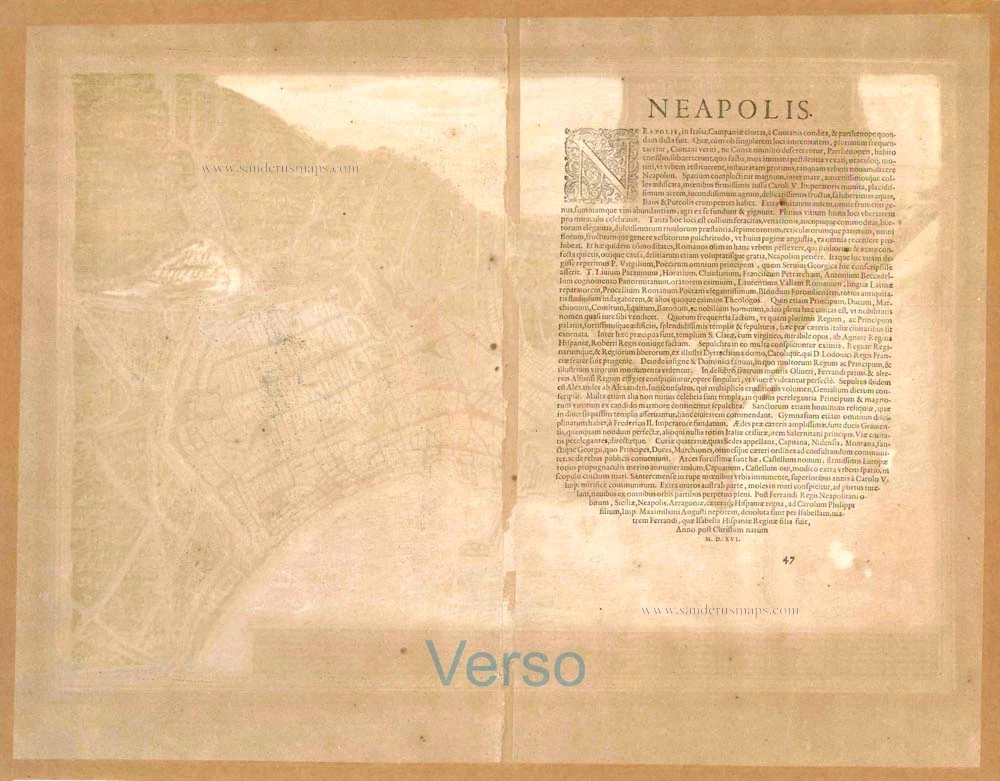
Verso: Latin text.
Condition: Original coloured, heightened in gold, margins browned due to prior framing.
Condition Rating: A
References: Van der Krogt 4, 2988 State 1; Fauser, #9603; Taschen, Br. Hog. p.112; Pane & Valerio (Napoli), #14
From: Civitates Orbis Terrarum, Liber Primus. Cologne, Petrus von Brachel, 1612. (Van der Krogt 4, 41:1.1(1612))
TRANSLATION CARTOUCHE: This is the notable and flourishing city of Naples in Campania, formerly called Parthenope, after Parthenope the siren, who was buried in this place. As legend relates, the sirens cast themselves into the sea in fury after they had been unable to seduce Odysseus and his companions with their song. Naples, today the residence of illustrious families and most learned men, is distinguished for the wonderful mildness of its air and its delightful location, the magnificence of its churches, private houses and palaces, beautiful tombs of kings, queens and high-ranking persons, and a university with all the faculties.
COMMENTARY BY BRAUN: "The fertile region around Naples [...] was the reason that the Romans liked to go to Naples after their work to rest and relax and to seek entertainment. This is where, amongst others, the most excellent poet Virgil lived, who wrote his Georgica book on agriculture here, so Servius says. Livy, Horace, Claudianus, Francesco Petrarch, Lorenzo Valla, Flavio Biondo and many others also lived here. [...] The streets are clean and straight. The strongest fortress in Naples is the Castel Nuovo, which may be rightly considered the safest castle in all Europe."
Naples is presented from a plan-like bird's-eye view. The dominant impression is of a bustling city and trading port with a well-designed layout and impregnable citadel. Naples saw its greatest flowering in the early modern era under Alfonso V of Aragon, who as Alfonso I was also king of Naples and Sicily. Between 1450 and 1550 it grew from 40,000 to 210,000 inhabitants and thereby became Europe's second-largest city after Paris. Noteworthy here are the three forts: the Castel Nuovo (10) lies directly on the seafront beside the large mole. On the rocky promontory on the left, the Castel dell'Ovo (12) in the Santa Lucia district is a harbour fort from the 9th century. Looking out over the bay from above the city, lastly, is the 14th-centuy Castle Sant'Elmo (Castel S. Martino, 11), next to the Certosa di San Martino (41). (Taschen)
Braun G. & Hogenberg F. and the Civitates Orbis Terrarum.
The Civitates Orbis Terrarum, also known as the 'Braun & Hogenberg', is a six-volume town atlas and the most excellent book of town views and plans ever published: 363 engravings, sometimes beautifully coloured. It was one of the best-selling works in the last quarter of the 16th century. Georg Braun, a skilled writer, wrote the text accompanying the plans and views on the verso. Many plates were engraved after the original drawings of a professional artist, Joris Hoefnagel (1542-1600). The first volume was published in Latin in 1572 and the sixth in 1617. Frans Hogenberg, a talented engraver, created the tables for volumes I through IV, and Simon van den Neuwel made those for volumes V and VI. Other contributors were cartographers Daniel Freese and Heinrich Rantzau, who provided valuable geographical information. Works by Jacob van Deventer, Sebastian Münster, and Johannes Stumpf were also used as references. Translations appeared in German and French, making the atlas accessible to a broader audience.
Since its original publication of volume 1 in 1572, the Civitates Orbis Terrarum has left an indelible mark on the history of cartography. Seven more editions followed the first volume in 1575, 1577, 1582, 1588, 1593, 1599, and 1612. Vol.2, initially released in 1575, saw subsequent editions in 1597 and 1612. The subsequent volumes, each a treasure trove of historical insights, graced the world in 1581, 1588, 1593, 1599, and 1606. The German translation of the first volume, a testament to its widespread appeal, debuted in 1574, followed by the French edition in 1575.
Several printers were involved: Theodor Graminaeus, Heinrich von Aich, Gottfried von Kempen, Johannis Sinniger, Bertram Buchholtz, and Peter von Brachel, all of whom worked in Cologne.
Georg Braun (1541-1622)
Georg Braun, the author of the text accompanying the plans and views in the Civitates Orbis Terrarum, was born in Cologne in 1541. After his studies in Cologne, he entered the Jesuit Order as a novice, indicating his commitment to learning and intellectual pursuits. In 1561, he obtained his bachelor's degree; in 1562, he received his Magister Artium, further demonstrating his academic achievements. Although he left the Jesuit Order, he continued his studies in theology, gaining a licentiate in theology. His theological background likely influenced the content and tone of the text in the Civitates Orbis Terrarum, adding a unique perspective to the work.
Frans Hogenberg (1535-1590)
Frans Hogenberg was a Flemish and German painter, engraver, and mapmaker. He was born in Mechelen as the son of Nicolaas Hogenberg.
By the end of the 1560s, Frans Hogenberg was employed upon Abraham Ortelius's Theatrum Orbis Terrarum, published in 1570; he is named an engraver of numerous maps. In 1568, he was banned from Antwerp by the Duke of Alva and travelled to London, where he stayed a few years before emigrating to Cologne. He immediately embarked on his two most important works, the Civitates, published in 1572 and the Geschichtsblätter, which appeared in several series from 1569 until about 1587.
Thanks to large-scale projects like the Geschichtsblätter and the Civitates, Hogenberg's social circumstances improved with each passing year. He died as a wealthy man in Cologne in 1590.
Related items
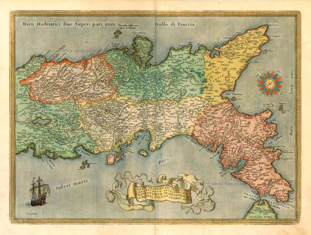
Regni Neapolitani Verissima Secundum Antiquorum et Recentiorum Traditionem Descriptio, Pyrrho Ligorio Auct. 1601
Napoli, by A. Ortelius.
[Item number: 8072]
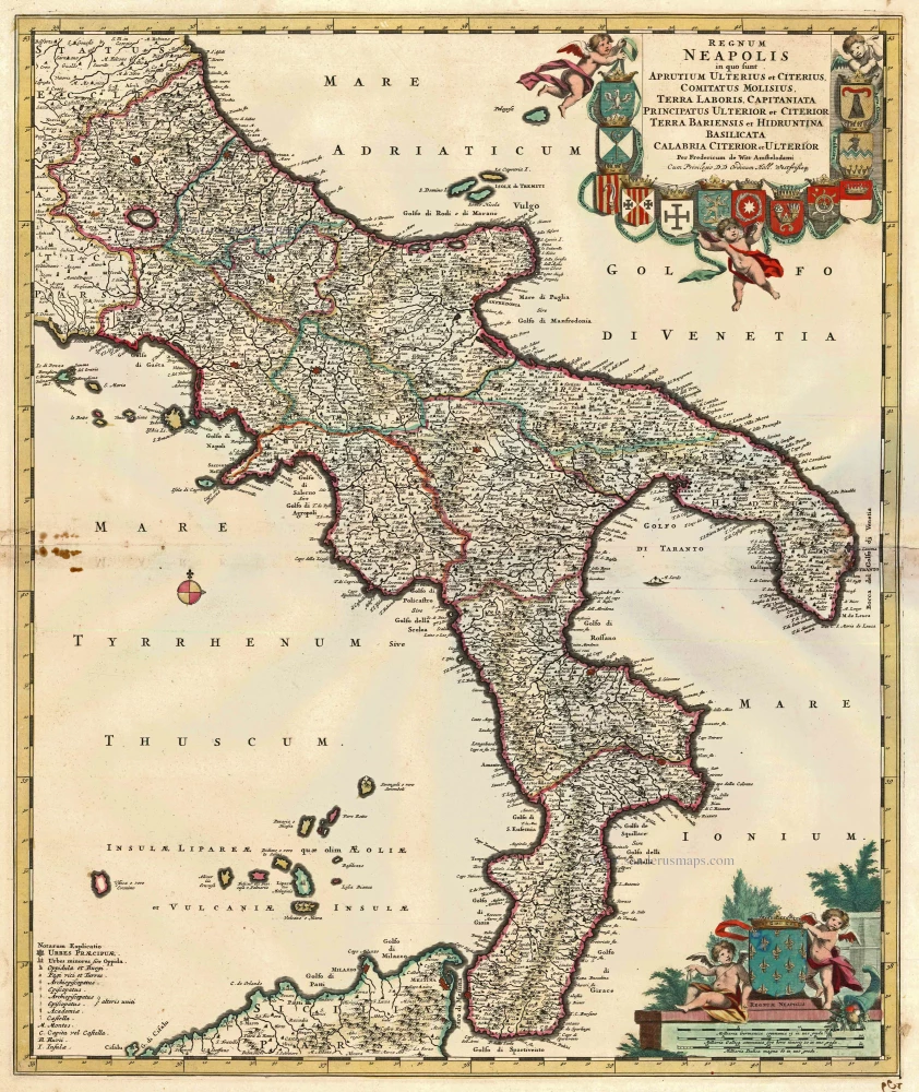
Regnum Neapolis in quo sunt Aprutium Ulterius et Citerius, Comitatus Molisius, Terra Laboris, Capitaniata Orincipatus Ulterior et Citerior Terra Bariensis et Hidruntina Basilicata Calabria Citerior et Ulterior. c. 1680
Napoli (Kingdom) by Frederik de Wit.
[Item number: 14832]
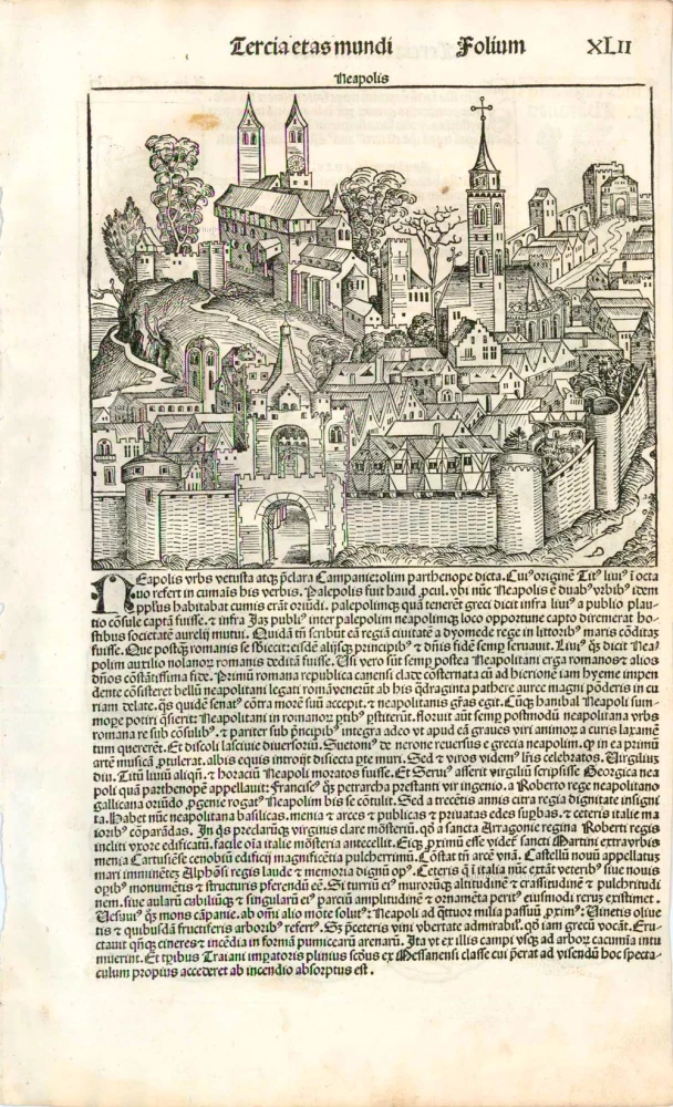
Neapolis. 1493
Naples (Napoli) by Schedel H.
[Item number: 24705]
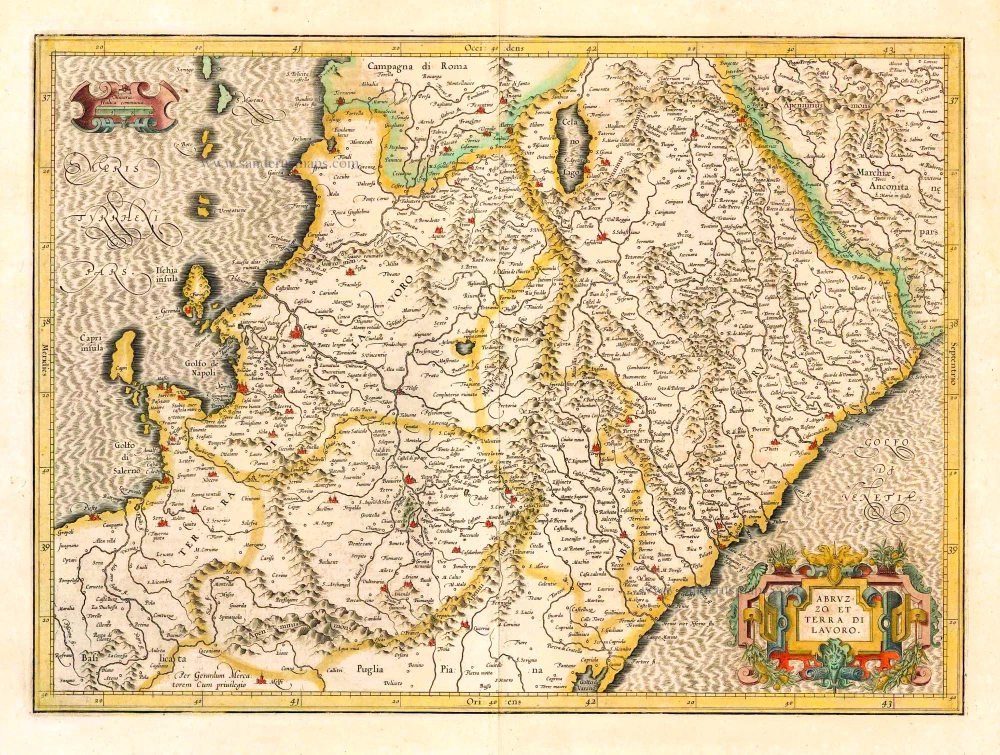
Abruzzo et Terra di Lavoro. 1619
Napoli (North) by Gerard Mercator.
[Item number: 26116]
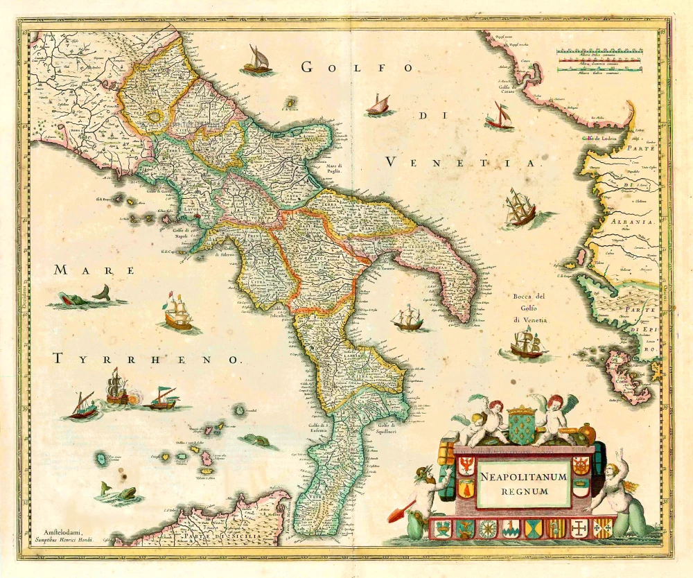
Neapolitanum Regnum. 1641
The Kingdom of Napoli, by Henricus Hondius.
[Item number: 26406]
Big and spectacular view
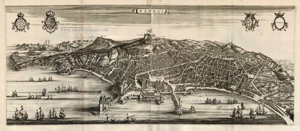
Napoli. 1704
Napels (Napoli), by Pieter Mortier.
[Item number: 27910]
![Profile and map of Capri [on verso:] bird's-eye view plan of Naples (Napoli), by Vincenzo Coronelli.](https://sanderusmaps.com/assets/WEBP/m28887.webp)
Isola di Capri. / La Citta di Napoli. 1696
Profile and map of Capri [on verso:] bird's-eye view plan of Naples (Napoli), by Vincenzo Coronelli.
[Item number: 28887]

Novißima & exactißima Totius Regni Neapolis. c. 1720
Kingdom of Naples (Napoli), by J.B. Homann.
[Item number: 32300]