
Milan (Milano) by Georg Braun & Frans Hogenberg. 1572
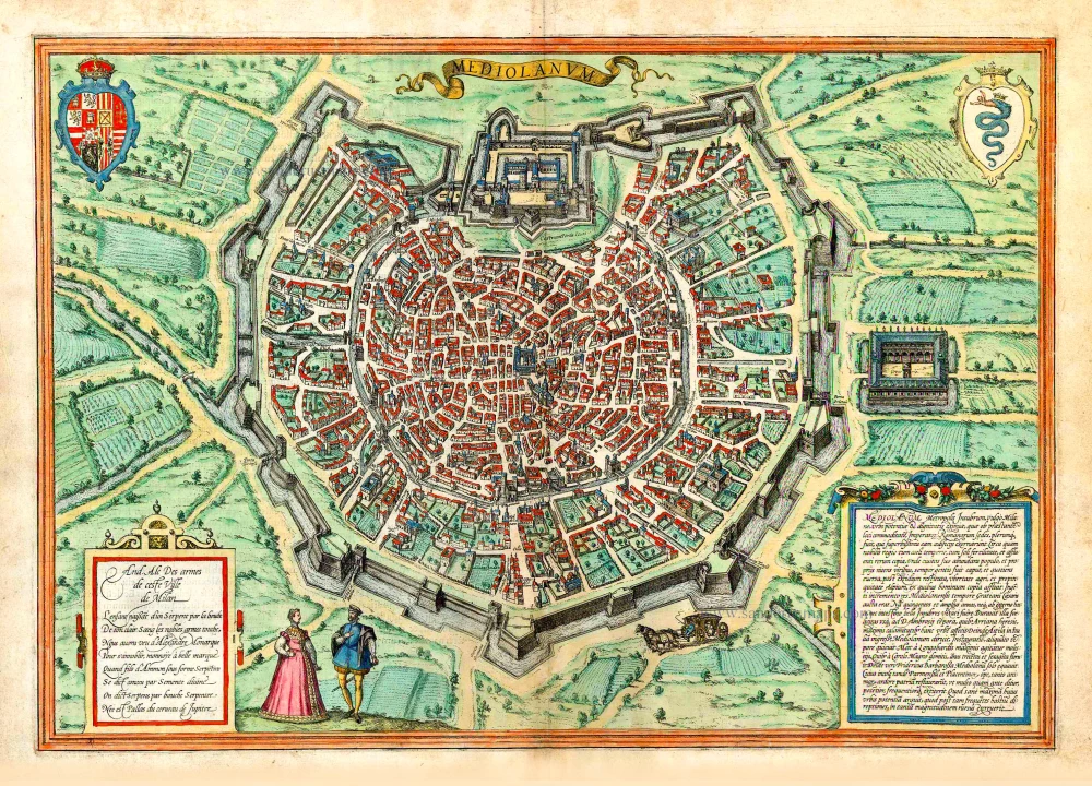


CARTOUCHE LEFT: Commentary on the city's coat of arms top right by the humanist and emblematician Andrea Alciato.
TRANSLATION CARTOUCHE RIGHT: Mediolanum, the capital of the Insubrians, commonly known as Milan, was an extremely powerful and dignified city, which due to its favourable location, was generally the seat of the Roman emperors, who embellished it with superb buildings. The region around Milan has a temperate climate, the soils are fertile, and everything is abundant. [...] The fecund fields and the proximity to the Alps meant that many people flocked from the latter to Milan. Due to a large influx at the time of Emperor Gratian, Milan grew bigger. For over 500 years, the Insubrians were troubled neither by external enemies nor internal fighting. This good fortune lasted until the time of St Ambrose when the Arian heresy inflicted great harm upon the city. Then Attila, who had invaded Italy, destroyed Milan. For a long time after its reconstruction, it had peace. Then it was visited by the Lombards. After their subjugation by Charlemagne, it flourished for 360 years. But then Frederick Barbarossa razed Milan to the ground. With the help of Parma and Piacenza, its inhabitants rebuilt their city with such zeal and ardour that it arose even more prosperous, powerful and populated than before [...].
COMMENTARY BY BRAUN: "Milan can be numbered amongst the largest cities in Europe. Running through its suburbs are canals, along which all the necessities of life can be brought into the city by boat. So many different artisans live here that it is said that there are enough to rebuild Italy, but first, you would have to destroy Milan to persuade its craftsmen and artists to migrate across the rest of Italy. The city has many magnificent houses, each more beautiful than the next, including its main church, with which few order churches in the whole world bear comparison in terms of size and marble décor."
The plan view conveys an impressive picture of the city's distinctively regular layout. The bastion-like city wall replaced the medieval fortifications in the 16th/17th centuries, which is particularly easy to recognize from this bird's-eye perspective. It starts from the Castello Sforzesco (top centre), the former fortified palace of the Sforza Dukes of Milan. In the very centre of the city lies the cathedral of Santa Maria Nascente, which commenced in the 14th century and was consecrated in 1572. The Gothic city core is located around the cathedral of Santa Maria Nascente, which commenced in the 14th century and was consecrated in 1572. The Gothic city core is located around the cathedral square. Milan's oldest churches are also visible in this engraving, founded in the 4th century: San Lorenzo Maggiore (centre left), Sant'Ambrogio (top left) and Sant'Eustorgio. Leonardo da Vinci's famous Last Supper (1495/97) is housed in Santa Maria delle Grazie (left of the Castello). When Francesco Sforza died without heirs in 1535, Milan passed to Emperor Charles V, who in 1555 bequeathed it in turn to his son Philip II of Spain. Milan remained in Spanish possession until the 18th century. The city is today Italy's financial, fashion and media capital, with 1.3 million inhabitants. (Taschen)
Braun G. & Hogenberg F. and the Civitates Orbis Terrarum.
The Civitates Orbis Terrarum, also known as the 'Braun & Hogenberg', is a six-volume town atlas and the most excellent book of town views and plans ever published: 363 engravings, sometimes beautifully coloured. It was one of the best-selling works in the last quarter of the 16th century. Georg Braun, a skilled writer, wrote the text accompanying the plans and views on the verso. Many plates were engraved after the original drawings of a professional artist, Joris Hoefnagel (1542-1600). The first volume was published in Latin in 1572 and the sixth in 1617. Frans Hogenberg, a talented engraver, created the tables for volumes I through IV, and Simon van den Neuwel made those for volumes V and VI. Other contributors were cartographers Daniel Freese and Heinrich Rantzau, who provided valuable geographical information. Works by Jacob van Deventer, Sebastian Münster, and Johannes Stumpf were also used as references. Translations appeared in German and French, making the atlas accessible to a broader audience.
Since its original publication of volume 1 in 1572, the Civitates Orbis Terrarum has left an indelible mark on the history of cartography. Seven more editions followed the first volume in 1575, 1577, 1582, 1588, 1593, 1599, and 1612. Vol.2, initially released in 1575, saw subsequent editions in 1597 and 1612. The subsequent volumes, each a treasure trove of historical insights, graced the world in 1581, 1588, 1593, 1599, and 1606. The German translation of the first volume, a testament to its widespread appeal, debuted in 1574, followed by the French edition in 1575.
Several printers were involved: Theodor Graminaeus, Heinrich von Aich, Gottfried von Kempen, Johannis Sinniger, Bertram Buchholtz, and Peter von Brachel, all of whom worked in Cologne.
Georg Braun (1541-1622)
Georg Braun, the author of the text accompanying the plans and views in the Civitates Orbis Terrarum, was born in Cologne in 1541. After his studies in Cologne, he entered the Jesuit Order as a novice, indicating his commitment to learning and intellectual pursuits. In 1561, he obtained his bachelor's degree; in 1562, he received his Magister Artium, further demonstrating his academic achievements. Although he left the Jesuit Order, he continued his studies in theology, gaining a licentiate in theology. His theological background likely influenced the content and tone of the text in the Civitates Orbis Terrarum, adding a unique perspective to the work.
Frans Hogenberg (1535-1590)
Frans Hogenberg was a Flemish and German painter, engraver, and mapmaker. He was born in Mechelen as the son of Nicolaas Hogenberg.
By the end of the 1560s, Frans Hogenberg was employed upon Abraham Ortelius's Theatrum Orbis Terrarum, published in 1570; he is named an engraver of numerous maps. In 1568, he was banned from Antwerp by the Duke of Alva and travelled to London, where he stayed a few years before emigrating to Cologne. He immediately embarked on his two most important works, the Civitates, published in 1572 and the Geschichtsblätter, which appeared in several series from 1569 until about 1587.
Thanks to large-scale projects like the Geschichtsblätter and the Civitates, Hogenberg's social circumstances improved with each passing year. He died as a wealthy man in Cologne in 1590.
Mediolanum Metropolis Insubrum, vulgo Milano, ...
Item Number: 27057 Authenticity Guarantee
Category: Antique maps > Europe > Italy - Cities
Old, antique bird's-eye view plan of Milan (Milano) by Braun Georg & Hogenberg Frans.
Title: Mediolanum Metropolis Insubrum, vulgo Milano, ...
Date of the first edition: 1572.
Date of this map: 1572.
Copper engraving, printed on paper.
Size (not including margins): 335 x 485mm (13.19 x 19.09 inches).
Verso: Latin text.
Condition: Original coloured, excellent.
Condition Rating: A+.
From: Civitates Orbis Terrarum, Liber Primus. Cologne, Theodor Graminaeus, 1572.. (Van der Krogt 4, 41:0)
CARTOUCHE LEFT: Commentary on the city's coat of arms top right by the humanist and emblematician Andrea Alciato.
TRANSLATION CARTOUCHE RIGHT: Mediolanum, the capital of the Insubrians, commonly known as Milan, was an extremely powerful and dignified city, which due to its favourable location, was generally the seat of the Roman emperors, who embellished it with superb buildings. The region around Milan has a temperate climate, the soils are fertile, and everything is abundant. [...] The fecund fields and the proximity to the Alps meant that many people flocked from the latter to Milan. Due to a large influx at the time of Emperor Gratian, Milan grew bigger. For over 500 years, the Insubrians were troubled neither by external enemies nor internal fighting. This good fortune lasted until the time of St Ambrose when the Arian heresy inflicted great harm upon the city. Then Attila, who had invaded Italy, destroyed Milan. For a long time after its reconstruction, it had peace. Then it was visited by the Lombards. After their subjugation by Charlemagne, it flourished for 360 years. But then Frederick Barbarossa razed Milan to the ground. With the help of Parma and Piacenza, its inhabitants rebuilt their city with such zeal and ardour that it arose even more prosperous, powerful and populated than before [...].
COMMENTARY BY BRAUN: "Milan can be numbered amongst the largest cities in Europe. Running through its suburbs are canals, along which all the necessities of life can be brought into the city by boat. So many different artisans live here that it is said that there are enough to rebuild Italy, but first, you would have to destroy Milan to persuade its craftsmen and artists to migrate across the rest of Italy. The city has many magnificent houses, each more beautiful than the next, including its main church, with which few order churches in the whole world bear comparison in terms of size and marble décor."
The plan view conveys an impressive picture of the city's distinctively regular layout. The bastion-like city wall replaced the medieval fortifications in the 16th/17th centuries, which is particularly easy to recognize from this bird's-eye perspective. It starts from the Castello Sforzesco (top centre), the former fortified palace of the Sforza Dukes of Milan. In the very centre of the city lies the cathedral of Santa Maria Nascente, which commenced in the 14th century and was consecrated in 1572. The Gothic city core is located around the cathedral of Santa Maria Nascente, which commenced in the 14th century and was consecrated in 1572. The Gothic city core is located around the cathedral square. Milan's oldest churches are also visible in this engraving, founded in the 4th century: San Lorenzo Maggiore (centre left), Sant'Ambrogio (top left) and Sant'Eustorgio. Leonardo da Vinci's famous Last Supper (1495/97) is housed in Santa Maria delle Grazie (left of the Castello). When Francesco Sforza died without heirs in 1535, Milan passed to Emperor Charles V, who in 1555 bequeathed it in turn to his son Philip II of Spain. Milan remained in Spanish possession until the 18th century. The city is today Italy's financial, fashion and media capital, with 1.3 million inhabitants. (Taschen)
Braun G. & Hogenberg F. and the Civitates Orbis Terrarum.
The Civitates Orbis Terrarum, also known as the 'Braun & Hogenberg', is a six-volume town atlas and the most excellent book of town views and plans ever published: 363 engravings, sometimes beautifully coloured. It was one of the best-selling works in the last quarter of the 16th century. Georg Braun, a skilled writer, wrote the text accompanying the plans and views on the verso. Many plates were engraved after the original drawings of a professional artist, Joris Hoefnagel (1542-1600). The first volume was published in Latin in 1572 and the sixth in 1617. Frans Hogenberg, a talented engraver, created the tables for volumes I through IV, and Simon van den Neuwel made those for volumes V and VI. Other contributors were cartographers Daniel Freese and Heinrich Rantzau, who provided valuable geographical information. Works by Jacob van Deventer, Sebastian Münster, and Johannes Stumpf were also used as references. Translations appeared in German and French, making the atlas accessible to a broader audience.
Since its original publication of volume 1 in 1572, the Civitates Orbis Terrarum has left an indelible mark on the history of cartography. Seven more editions followed the first volume in 1575, 1577, 1582, 1588, 1593, 1599, and 1612. Vol.2, initially released in 1575, saw subsequent editions in 1597 and 1612. The subsequent volumes, each a treasure trove of historical insights, graced the world in 1581, 1588, 1593, 1599, and 1606. The German translation of the first volume, a testament to its widespread appeal, debuted in 1574, followed by the French edition in 1575.
Several printers were involved: Theodor Graminaeus, Heinrich von Aich, Gottfried von Kempen, Johannis Sinniger, Bertram Buchholtz, and Peter von Brachel, all of whom worked in Cologne.
Georg Braun (1541-1622)
Georg Braun, the author of the text accompanying the plans and views in the Civitates Orbis Terrarum, was born in Cologne in 1541. After his studies in Cologne, he entered the Jesuit Order as a novice, indicating his commitment to learning and intellectual pursuits. In 1561, he obtained his bachelor's degree; in 1562, he received his Magister Artium, further demonstrating his academic achievements. Although he left the Jesuit Order, he continued his studies in theology, gaining a licentiate in theology. His theological background likely influenced the content and tone of the text in the Civitates Orbis Terrarum, adding a unique perspective to the work.
Frans Hogenberg (1535-1590)
Frans Hogenberg was a Flemish and German painter, engraver, and mapmaker. He was born in Mechelen as the son of Nicolaas Hogenberg.
By the end of the 1560s, Frans Hogenberg was employed upon Abraham Ortelius's Theatrum Orbis Terrarum, published in 1570; he is named an engraver of numerous maps. In 1568, he was banned from Antwerp by the Duke of Alva and travelled to London, where he stayed a few years before emigrating to Cologne. He immediately embarked on his two most important works, the Civitates, published in 1572 and the Geschichtsblätter, which appeared in several series from 1569 until about 1587.
Thanks to large-scale projects like the Geschichtsblätter and the Civitates, Hogenberg's social circumstances improved with each passing year. He died as a wealthy man in Cologne in 1590.
Related items
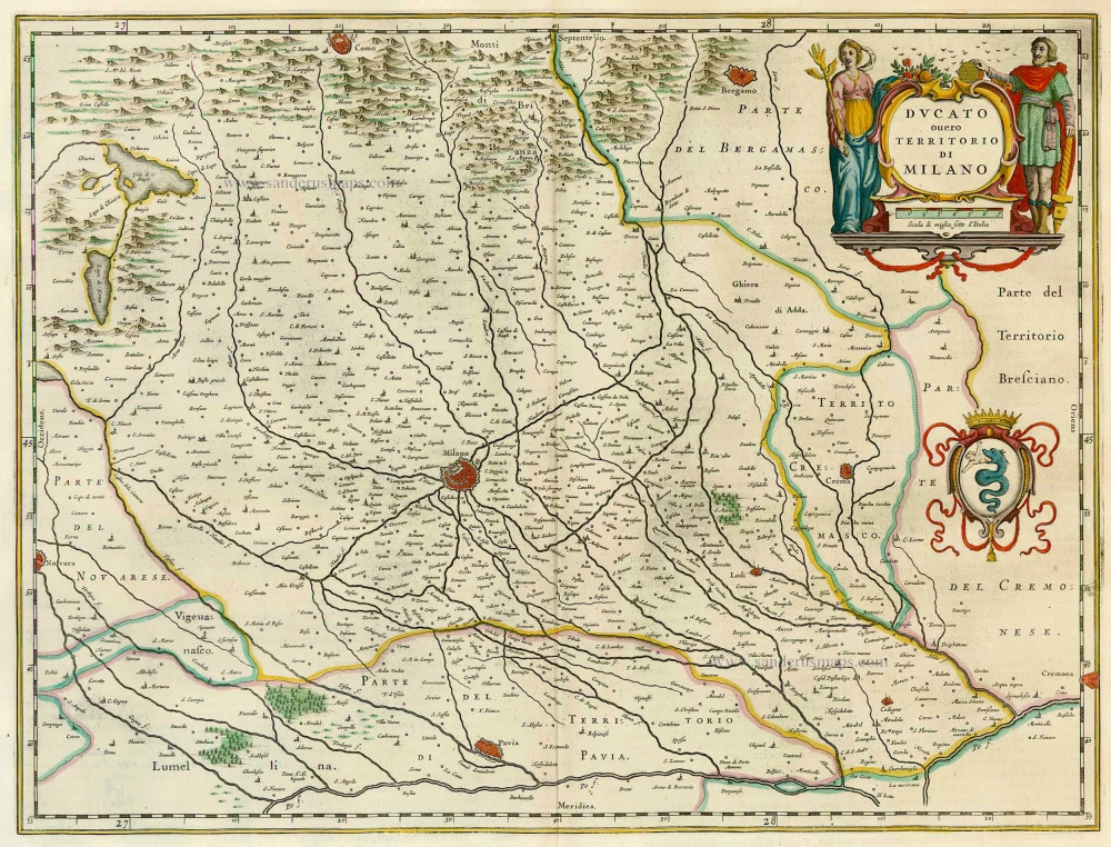
Ducato ouero Territorio di Milano 1664-65
Milano, by J. Blaeu.
[Item number: 7057]
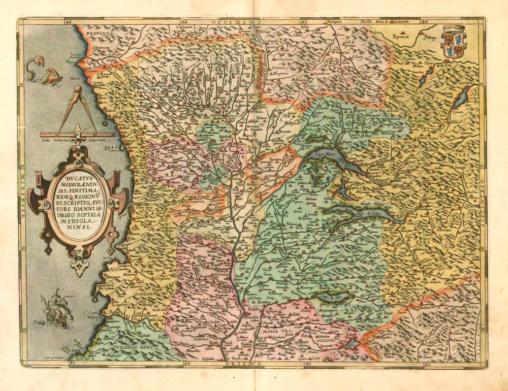
Ducatus Mediolanensis, finitimarumq, Regionu descriptio, auctore Ioanne Georgio Septala Mediolanense. 1601
Milano by A. Ortelius.
[Item number: 8062]
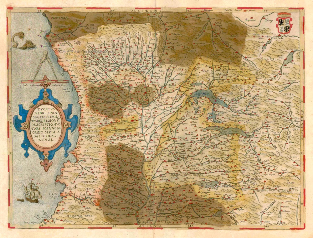
Ducatus Mediolanensis, finitimarumq, Regionu descriptio, auctore Ioanne Georgio Septala Mediolanense. 1579
Milano by Abraham Ortelius.
[Item number: 23348]
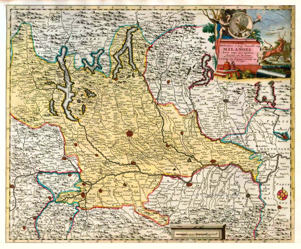
Carte Particuliere et toute Nouvelle du Milanois. Avec tous ses confins. 1713
Milano, by P. Van der Aa.
[Item number: 26084]
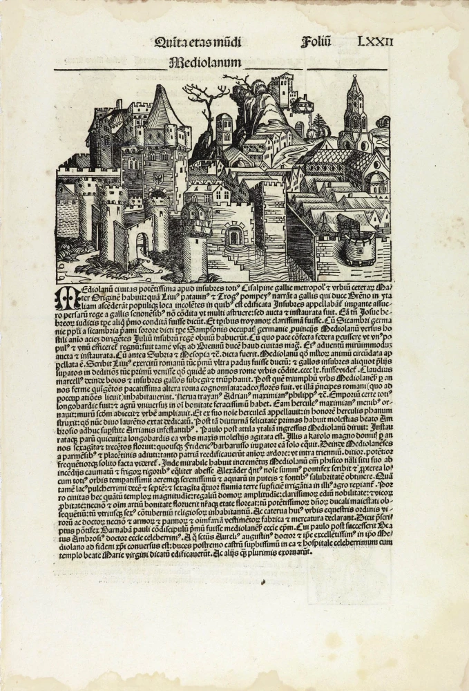
Mediolanum. 1493
Milano by Hartmann Schedel.
[Item number: 28339]