
Ancient Italy, by Paolo Santini, after Nicolas Sanson & Sr. Robert de Vaugondy. 1776-79

Francesco and Paolo Santini (c.1729-1793)
Francesco Santini, a Venetian publisher, acquired the printing plates of Vaugondy’s Atlas Universel …, a commercial and cartographic success, with widespread influence on mapmakers throughout Europe. Together with his brother Paolo, he commissioned a new set of plates and reissued the atlas in 1776. The following year, Paolo Santini assigned all his publication rights to M. Remondini, who in 1777 reissued the same atlas but with his name.
SANSON FAMILY
Nicolas Sanson (1600-1667) - Guillaume Sanson (1633-1703) - Pierre Moullart-Sanson (? -1730)
Originally from Abbeville, Nicolas I Sanson showed a keen interest in historical geography. He was still very young; he published a map of ancient Gaul and two treatises, Britannia and Portus Itius on Abbeville and Boulogne's origins. His meeting with Melchior Tavernier was decisive: it prompted him to give up his duties as a military engineer in Picardy and devote himself to engraved cartography.
At the same time, Sanson had drawn up the outline of modern France. He got the help of Tavernier, who encouraged him to compete with the Dutch map publishers. Tavernier contacted other French cartographers whose works he published.
From 1643, N. Sanson obtained a privilege to publish a work personally, the Princes souverains de l'Italie. Then, in 1644 and 1645, he had his famous geographical tables printed, which significantly contributed to his fame. He also published a series of atlases in quarto of the four continents.
In 1648, N. Sanson associated himself with Mariette to publish atlases. From then on, specific maps bore his name and others Mariette's. N. Sanson and Mariette worked together for more than 20 years. After the death of N. Sanson, Mariette acquired the entire fund. Since Mariette only wanted to publish complete atlases, individual maps were no longer sold, and some army generals complained to the king.
The disagreement between the Sanson family and Pierre II Mariette culminated in 1671 when Guillaume Sanson took the case to court. There was no longer any question of collaboration: Guillaume Sanson started working for another publisher, Alexis-Hubert Jaillot.
The Sanson family faced financial difficulties, and in 1692, their cousin, Pierre Moullart-Sanson, bought the entire geographic fund from his uncles and aunt. Pierre Moullart-Sanson was the son of Françoise Sanson (third child of Nicolas) and Pierre Moullart. He restarted the publishing of Sanson's world atlas, and in 1704 he acquired a privilege for publishing all the works of Nicolas and Guillaume Sanson, which continued to be published until 1730.
Gilles and Didier Robert de Vaugondy
Gilles Robert de Vaugondy (1688-1766) and his son Didier Robert de Vaugondy (1723-1786) were leading cartographers in France during the 18th century. They served both as geographer to the king of France. The father, Gilles is also known as ‘Le Sieur’ or ‘Monsieur Robert’. He descended from the Nicolas Sanson family through Sanson's grandson Pierre Moulard-Sanson, from whom he inherited Sanson's cartographic material. After Hubert Jaillot died in 1712, the de Vaugondy's acquired numerous copies of his maps and plates, which formed the basis of their beautiful Atlas Universel (1757).
Their business flourished from 1731 to 1778. They made a substantial contribution to the world of cartography.
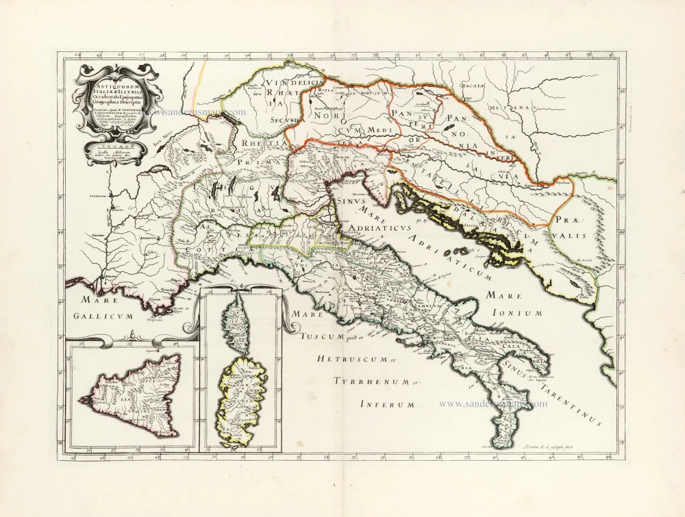
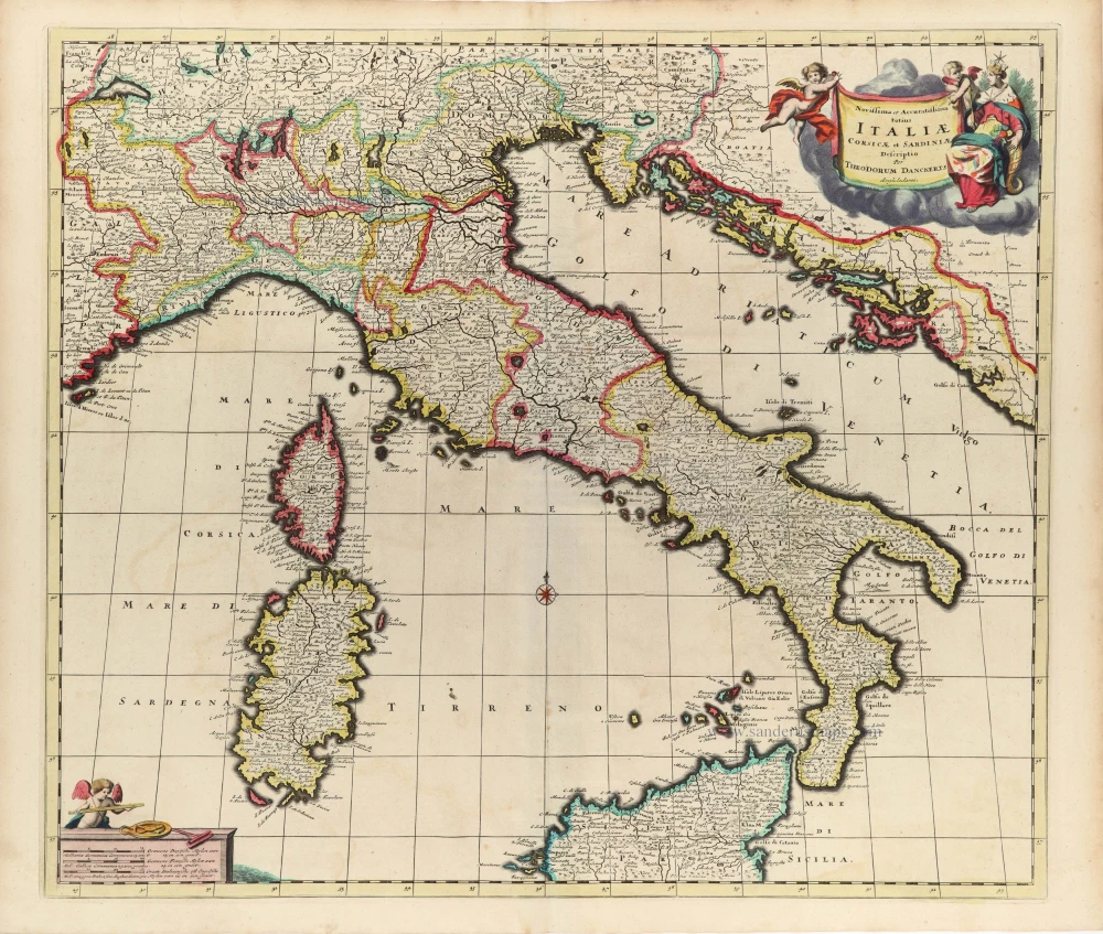
Italia Antiqua cum Insulis Sicilia, Sardinia, et Corsica,
Item Number: 28107 Authenticity Guarantee
Category: Antique maps > Europe > Italy
Ancient Italy, by Paolo Santini, after Nicolas Sanson & Sr. Robert de Vaugondy.
Title: Italia Antiqua cum Insulis Sicilia, Sardinia, et Corsica,
in suas majores partes et populos divisa,
a Nicolao Sanson Christ. Regis Geographo,
revisa et ad observationes astronomicas redacta
accurante Robert de Vaugondy filio.
A Venise | Par P. Santini 1778. | Chez Mr. Remondini.
Cartographer: Nicolas Sanson & Sr. Robert de Vaugondy.
Date of the first edition: 1751 (de Vaugondy).
Date of this map: 1776-79.
Date on map: 1778.
Copper engraving, printed on paper.
Size (not including margins): 475 x 560mm (18¾ x 22 inches).
Verso: Blank.
Condition: Original coloured in outline, excellent.
Condition Rating: A.
From: Atlas Universel dressé sur les meilleures cartes modernes. Venice, Remondini, 1776-79.
Francesco and Paolo Santini (c.1729-1793)
Francesco Santini, a Venetian publisher, acquired the printing plates of Vaugondy’s Atlas Universel …, a commercial and cartographic success, with widespread influence on mapmakers throughout Europe. Together with his brother Paolo, he commissioned a new set of plates and reissued the atlas in 1776. The following year, Paolo Santini assigned all his publication rights to M. Remondini, who in 1777 reissued the same atlas but with his name.
SANSON FAMILY
Nicolas Sanson (1600-1667) - Guillaume Sanson (1633-1703) - Pierre Moullart-Sanson (? -1730)
Originally from Abbeville, Nicolas I Sanson showed a keen interest in historical geography. He was still very young; he published a map of ancient Gaul and two treatises, Britannia and Portus Itius on Abbeville and Boulogne's origins. His meeting with Melchior Tavernier was decisive: it prompted him to give up his duties as a military engineer in Picardy and devote himself to engraved cartography.
At the same time, Sanson had drawn up the outline of modern France. He got the help of Tavernier, who encouraged him to compete with the Dutch map publishers. Tavernier contacted other French cartographers whose works he published.
From 1643, N. Sanson obtained a privilege to publish a work personally, the Princes souverains de l'Italie. Then, in 1644 and 1645, he had his famous geographical tables printed, which significantly contributed to his fame. He also published a series of atlases in quarto of the four continents.
In 1648, N. Sanson associated himself with Mariette to publish atlases. From then on, specific maps bore his name and others Mariette's. N. Sanson and Mariette worked together for more than 20 years. After the death of N. Sanson, Mariette acquired the entire fund. Since Mariette only wanted to publish complete atlases, individual maps were no longer sold, and some army generals complained to the king.
The disagreement between the Sanson family and Pierre II Mariette culminated in 1671 when Guillaume Sanson took the case to court. There was no longer any question of collaboration: Guillaume Sanson started working for another publisher, Alexis-Hubert Jaillot.
The Sanson family faced financial difficulties, and in 1692, their cousin, Pierre Moullart-Sanson, bought the entire geographic fund from his uncles and aunt. Pierre Moullart-Sanson was the son of Françoise Sanson (third child of Nicolas) and Pierre Moullart. He restarted the publishing of Sanson's world atlas, and in 1704 he acquired a privilege for publishing all the works of Nicolas and Guillaume Sanson, which continued to be published until 1730.
Gilles and Didier Robert de Vaugondy
Gilles Robert de Vaugondy (1688-1766) and his son Didier Robert de Vaugondy (1723-1786) were leading cartographers in France during the 18th century. They served both as geographer to the king of France. The father, Gilles is also known as ‘Le Sieur’ or ‘Monsieur Robert’. He descended from the Nicolas Sanson family through Sanson's grandson Pierre Moulard-Sanson, from whom he inherited Sanson's cartographic material. After Hubert Jaillot died in 1712, the de Vaugondy's acquired numerous copies of his maps and plates, which formed the basis of their beautiful Atlas Universel (1757).
Their business flourished from 1731 to 1778. They made a substantial contribution to the world of cartography.
Related items

Italia Antiqua Philippo Cluvero Borusso Designatore. / Iodocus Hondius excud. 1630
Ancient Italy, by J. Janssonius - J. Hondius.
[Item number: 26223]

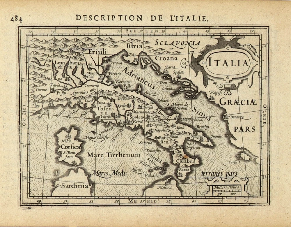
L'Italie Divisée en ses différents Etats, Royaumes et Républiques. 1776-79
Italy, by Sr. Janvier Jean Denis.
[Item number: 28076]

Nova Italiae Delineatio. 1642-43
Italy by Willem Blaeu.
[Item number: 28676]
Rare
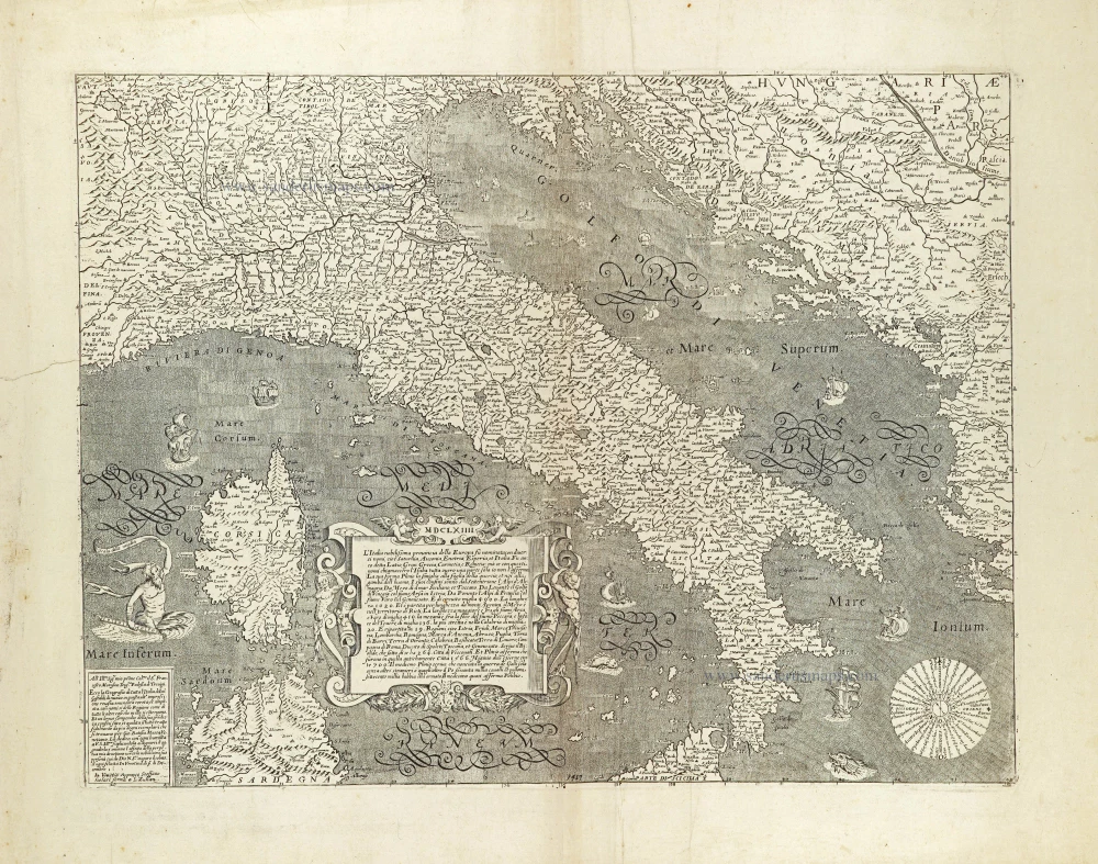
L'Italia nobilissima provincia della Europa su nominata con diversi nomi, ... 1664
Italy by Donato Rascicotti, published in Venice by Steffano Scolari.
[Item number: 28782]

Nouvelle Carte de L'Etat present de l'Italie pour parvenir par une Methode nouvelle, a la connoissance de la Geographie, et de l'Histoire; et tres utile pour les voiages. 1713
Map of Italy by Zacharias Châtelain.
[Item number: 29641]

Carte Generale de l'Italie et des Isles et Pays Circonvoisins. 1652
Italy by Nicolas Sanson.
[Item number: 29672]

Italia Antiqua Cum Insulis Sicilia Sardinia & Corsica. 1652
Ancient Italy (Italia) by Nicolas Sanson.
[Item number: 29692]
Antiquorum Italiae & Illyrici Occidentalis Episcopatuu Geographica descriptio. 1641 or later
Ancient Italy (Italia) & Dalmatia by Melchior Tavernier.
[Item number: 30035]
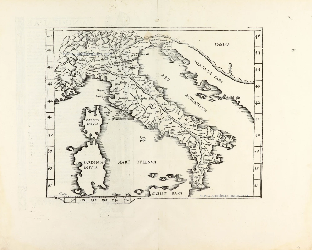
Ta .NO. Italiae. 1525
Italy, by Lorenz Fries.
[Item number: 30321]

Tabula .VI. Euro. 1525
Ptolemy map of Italy by Lorenz Fries, after Martin Waldseemüller.
[Item number: 30370]

Italiae Novissima Descriptio Auctore Iacobo Castaldo Pedemontano. 1584
Italy by Abraham Ortelius.
[Item number: 30985]

Italien in seine unterschiedene Laender eingeteilet c. 1745.
Italy by J.G. Schreiber.
[Item number: 31106]

L'Italie distinguée suivant l'estendue de tous les Estats, Royaumes, Republiques, Duchés, Principautés qui la partagent presentement. 1692
Italy by N. Sanson, so-called published by Hubert Jaillot. (Pirated edition by Pierre Mortier).
[Item number: 31275]
Italia. 1618
Italy by Petrus Bertius, published by Jodocus Hondius II.
[Item number: 31645]
Scarce and decorative map
Novissima et Accuratissima totius Italiae Corsicae et Sardiniae. c. 1680
Italy by Theodore Danckerts.
[Item number: 32501]