
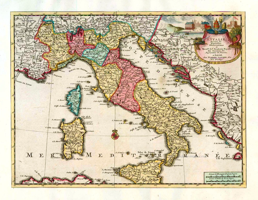
Map of Italy by Zacharias Châtelain. 1713

The Châtelain Family
Zacharias Châtelain (1684-1743) was a bookseller and publisher of Amsterdam. He was succeeded by his sons Zacharias jr and Henry Abraham. The Châtelain family was best known for the historical atlas Atlas Historique, ou nouvelle introduction à l’histoire…, a major work of its time. It was an encyclopaedia in seven volumes, including geography as one of its main subjects. The atlas was published in Amsterdam in seven volumes in various editions with different imprints from 1705 to 1739. An anonym person (Mr. C***) compiled the work with compositions of text, maps, plates and chronological and genealogical tables by Gueudeville, except volume 7, where H.P. Limiers took over this task. The maps were made mainly after the work of Guillaume de l'Isle.
The 1705 edition was published with the imprint “L’Honoré & Châtelain”. Later editions had the imprint: “les Frères Châtelain Libraires” or “L’Honoré & Châtelain Libraires”.
Nouvelle Carte de L'Etat present de l'Italie pour parvenir par une Methode nouvelle, a la connoissance de la Geographie, et de l'Histoire; et tres utile pour les voiages.
Item Number: 29641 Authenticity Guarantee
Category: Antique maps > Europe > Italy
Old, antique map of Italy by Zacharias Châtelain.
Title: Nouvelle Carte de L'Etat present de l'Italie pour parvenir par une Methode nouvelle, a la connoissance de la Geographie, et de l'Histoire; et tres utile pour les voiages.
Date of the first edition: 1705.
Date of this map: 1713.
Copper engraving, printed on paper.
Map size, including text: 335 x 665mm (13.19 x 26.18 inches).
Sheet size: 440 x 660mm (17.32 x 25.98 inches).
Verso: Blank.
Condition: Excellent.
Condition Rating: A+.
From: Châtelain Z. Atlas Historique, ou Nouvelle Introduction A l'Histoire, à la Chronologie & à la Geographie Ancienne & Moderne; ... Tome Premier. Conténant la Gréce, l'Histoire Romaine, Rome Moderne, Naples, la France, l'Espagne, & les Provinces Unies.A Amsterdam, Chez L'Honoré & Châtelain, M.DCC.XIII. (1713). (Koeman II, p. 35, Cha2)
The Châtelain Family
Zacharias Châtelain (1684-1743) was a bookseller and publisher of Amsterdam. He was succeeded by his sons Zacharias jr and Henry Abraham. The Châtelain family was best known for the historical atlas Atlas Historique, ou nouvelle introduction à l’histoire…, a major work of its time. It was an encyclopaedia in seven volumes, including geography as one of its main subjects. The atlas was published in Amsterdam in seven volumes in various editions with different imprints from 1705 to 1739. An anonym person (Mr. C***) compiled the work with compositions of text, maps, plates and chronological and genealogical tables by Gueudeville, except volume 7, where H.P. Limiers took over this task. The maps were made mainly after the work of Guillaume de l'Isle.
The 1705 edition was published with the imprint “L’Honoré & Châtelain”. Later editions had the imprint: “les Frères Châtelain Libraires” or “L’Honoré & Châtelain Libraires”.
Related items

Italiae Veteris Specimen 1601
ITALY by Abraham Ortelius
[Item number: 12412]

Italia, Divisa in Statum Ecclesiasticum, Regnum Neapolitanum, Resp. Venetiarum, Genuae, et Lucae: Magnum Ducatum Etruriae, Ducatus Sabaudiae, Mediolani, Mutinae, Parmae et Mirandulae: Insulas Siliciam, Sardiniam, et Superjacentia Regna et Regiones c. 1730.
Italy, by Valk G.& L.
[Item number: 14145]

Italia XIX Nova Tabula. 1545
ITALY by Münster S.
[Item number: 17073]
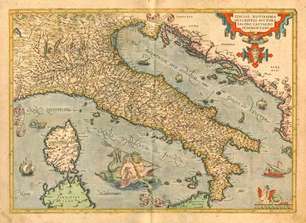
Italiae Novissima Descriptio Auctore Iacobo Castaldo Pedemontano. 1612
Italy by Abraham Ortelius
[Item number: 22982]
L'Italie. 1713
Italy, by Pieter Van der Aa.
[Item number: 26083]

Italia Antiqua Philippo Cluvero Borusso Designatore. / Iodocus Hondius excud. 1630
Ancient Italy, by J. Janssonius - J. Hondius.
[Item number: 26223]

Italia. 1597
Italy, by Giovanni Magini.
[Item number: 26517]

L'Italie Divisée en ses différents Etats, Royaumes et Républiques. 1776-79
Italy, by Sr. Janvier Jean Denis.
[Item number: 28076]

Italia Antiqua cum Insulis Sicilia, Sardinia, et Corsica, 1776-79
Ancient Italy, by Paolo Santini, after Nicolas Sanson & Sr. Robert de Vaugondy.
[Item number: 28107]
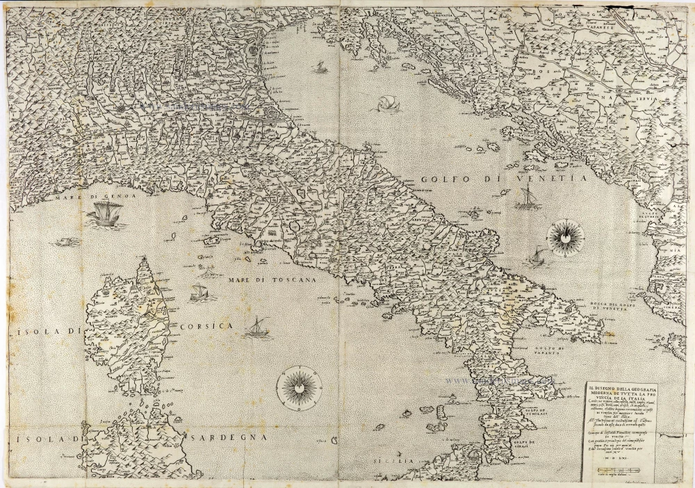
The most important Italy map of the 16th century
Il Disegno della Geografia Moderna de Tutta la Provincia de la Italia. 1561
Italy by Giacomo Gastaldi. (Italia)
[Item number: 28121]

Nova Italiae Delineatio. 1642-43
Italy by Willem Blaeu.
[Item number: 28676]
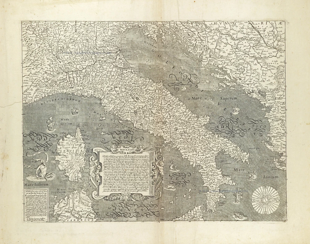
Rare
L'Italia nobilissima provincia della Europa su nominata con diversi nomi, ... 1664
Italy by Donato Rascicotti, published in Venice by Steffano Scolari.
[Item number: 28782]

Rare
Italiae, Sardiniae, Corsicae, et confinium Regionum nova Tabula, effigies praecipuarum Urbiu[m] et habituum inibi simul complectens. 1640
Italy, by Willem Blaeu, published by Cornelis Danckerts.
[Item number: 29405]

Carte Generale de l'Italie et des Isles et Pays Circonvoisins. 1652
Italy by Nicolas Sanson.
[Item number: 29672]

Italia Antiqua Cum Insulis Sicilia Sardinia & Corsica. 1652
Ancient Italy (Italia) by Nicolas Sanson.
[Item number: 29692]
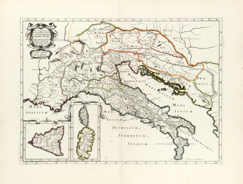
Antiquorum Italiae & Illyrici Occidentalis Episcopatuu Geographica descriptio. 1641 or later
Ancient Italy (Italia) & Dalmatia by Melchior Tavernier.
[Item number: 30035]

Tabula .VI. Euro. 1525
Ptolemy map of Italy by Lorenz Fries, after Martin Waldseemüller.
[Item number: 30370]

Italiae Veteris Specimen. 1595
Ancient Italy, by Abraham Ortelius
[Item number: 30532]

Italiae Novissima Descriptio Auctore Iacobo Castaldo Pedemontano. 1584
Italy by Abraham Ortelius.
[Item number: 30985]

Italien in seine unterschiedene Laender eingeteilet c. 1745.
Italy by J.G. Schreiber.
[Item number: 31106]

L'Italie distinguée suivant l'estendue de tous les Estats, Royaumes, Republiques, Duchés, Principautés qui la partagent presentement. 1692
Italy by N. Sanson, so-called published by Hubert Jaillot. (Pirated edition by Pierre Mortier).
[Item number: 31275]
Italia. 1618
Italy by Petrus Bertius, published by Jodocus Hondius II.
[Item number: 31645]
Scarce and decorative map
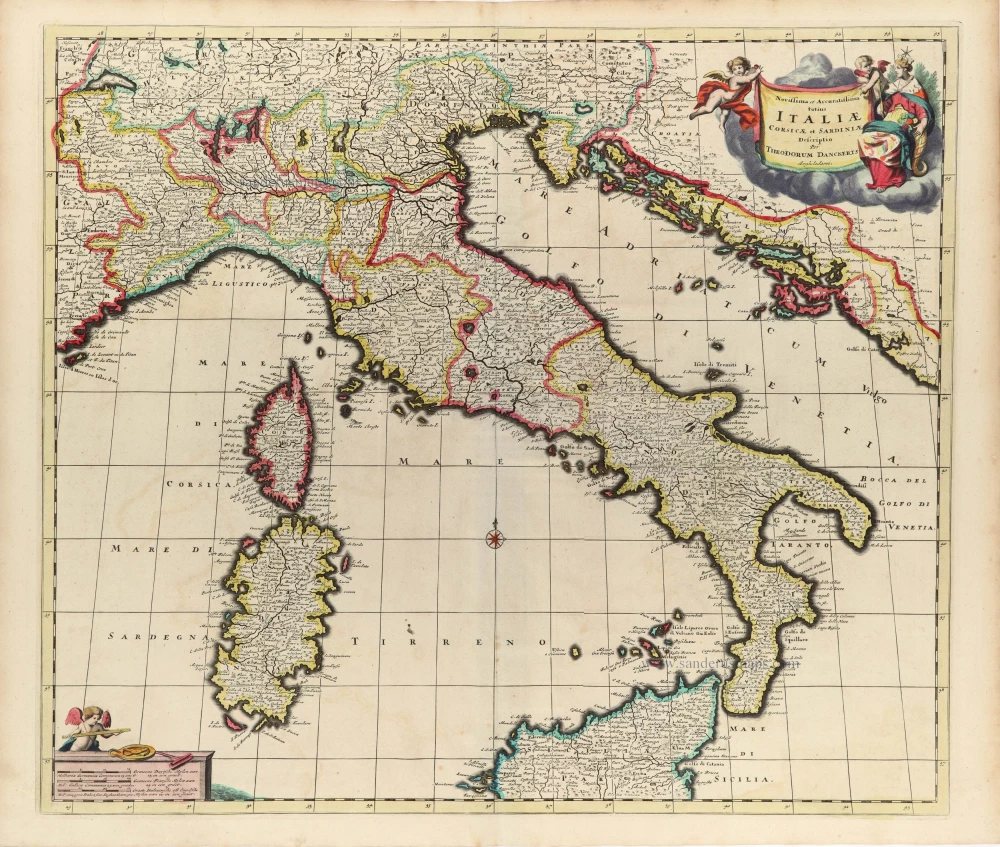
Novissima et Accuratissima totius Italiae Corsicae et Sardiniae. c. 1680
Italy by Theodore Danckerts.
[Item number: 32501]