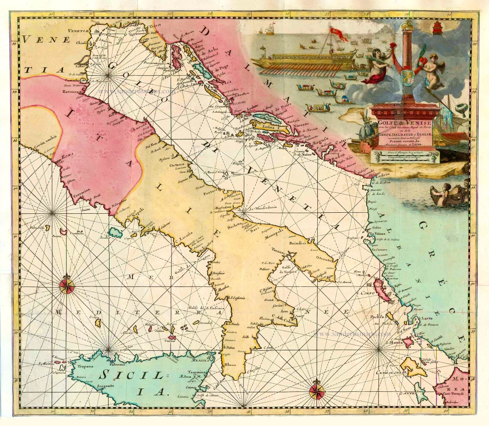
Gulf of Venice, by Zacharias Châtelain. 1708
The item displayed on this page has been sold. However, we have a similar map in stock:
Gulf of Venice, by Zacharias Châtelain. 1708
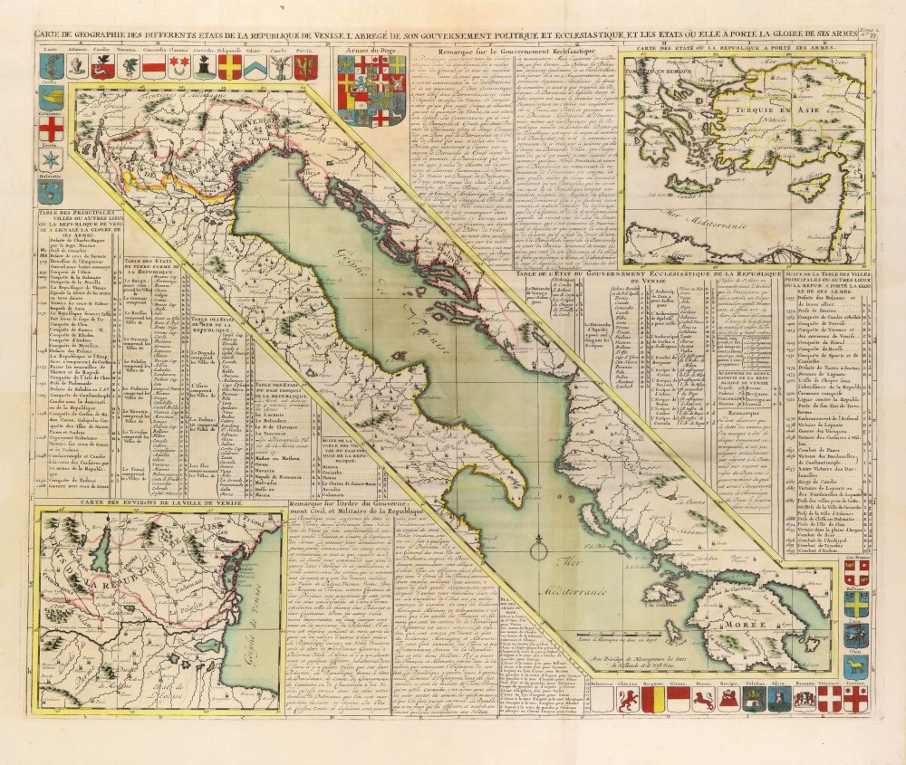
Carte de Géographie des differents Etats de la...
[Item number: 31420]
The Châtelain Family
Zacharias Châtelain (1684-1743) was a bookseller and publisher of Amsterdam. He was succeeded by his sons Zacharias jr and Henry Abraham. The Châtelain family was best known for the historical atlas Atlas Historique, ou nouvelle introduction à l’histoire…, a major work of its time. It was an encyclopaedia in seven volumes, including geography as one of its main subjects. The atlas was published in Amsterdam in seven volumes in various editions with different imprints from 1705 to 1739. An anonym person (Mr. C***) compiled the work with compositions of text, maps, plates and chronological and genealogical tables by Gueudeville, except volume 7, where H.P. Limiers took over this task. The maps were made mainly after the work of Guillaume de l'Isle.
The 1705 edition was published with the imprint “L’Honoré & Châtelain”. Later editions had the imprint: “les Frères Châtelain Libraires” or “L’Honoré & Châtelain Libraires”.
Carte de Géographie des differents Etats de la République de Venise, ...
Item Number: 29446 Authenticity Guarantee
Category: Antique maps > Europe > Italy
Old, antique map of the Gulf of Venice, with a map of the Western Mediterranean and one of the Venice area.
Title: Carte de Géographie des differents Etats de la République de Venise, ...
Tome 2 N° 73.
Date of the first edition: 1708.
Date of this map: 1708.
Copper engraving, printed on paper.
Map size: 500 x 610mm (19.69 x 24.02 inches).
Sheet size: 535 x 640mm (21.06 x 25.2 inches).
Verso: Blank.
Condition: Folds as issued, excellent.
Condition Rating: A+.
From: Châtelain Z. Atlas Historique, ou Nouvelle Introduction A l'Histoire, à la Chronologie & à la Geographie Ancienne & Moderne; ... Tome III. Qui comprend la Grande Bretagne, l'Irlande, la Suisse, la Savoye, La Loraine & la Republique de Venise. A Amsterdam, Chez L'Honoré & Châtelain Libraires, M.DCC.VIII. (1708). (Koeman II, p. 36, Cha4)
The Châtelain Family
Zacharias Châtelain (1684-1743) was a bookseller and publisher of Amsterdam. He was succeeded by his sons Zacharias jr and Henry Abraham. The Châtelain family was best known for the historical atlas Atlas Historique, ou nouvelle introduction à l’histoire…, a major work of its time. It was an encyclopaedia in seven volumes, including geography as one of its main subjects. The atlas was published in Amsterdam in seven volumes in various editions with different imprints from 1705 to 1739. An anonym person (Mr. C***) compiled the work with compositions of text, maps, plates and chronological and genealogical tables by Gueudeville, except volume 7, where H.P. Limiers took over this task. The maps were made mainly after the work of Guillaume de l'Isle.
The 1705 edition was published with the imprint “L’Honoré & Châtelain”. Later editions had the imprint: “les Frères Châtelain Libraires” or “L’Honoré & Châtelain Libraires”.