
Antique map of Leuven (Louvain) by Braun & Hogenberg 1581-88
The item displayed on this page has been sold. However, we have a similar map in stock:
Louvain by Georg Braun & Frans Hogenberg. 1599
Loeven - Lovanium, Brabanticarum urbium caput,...
[Item number: 29977]

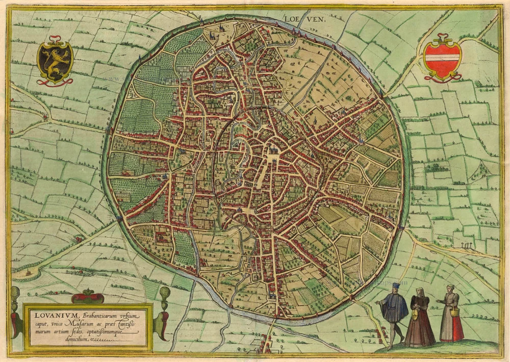
TRANSLATION OF CARTOUCHE TEXT: Louvain, capital of Brabant, is an unrivalled site of the muses and the most distinguished arts and sciences; a highly desirable place of residence.
COMMENTARY BY BRAUN (on verso): "Louvain is the capital of Brabant and an important trade city, but also the seat of learned men and the Liberal Arts. It was established around 1422 by John, Duke of Brabant, and is a large and liberal city. Inside the city walls, it also has open meadows, vineyards, other large gardens, arable fields, orchards, fields, bushes, forest and pastures and very sizeable woods for walking in. There is nowhere better suited to accommodate the muses and scholarship than this city."
From a detailed bird's-eye perspective, Louvain appears less organized within its circular boundary than other cities and is crisscrossed by a network of labyrinthine medieval streets. Few prominent buildings are documented; only the church of Sint-Pieter on the large marketplace opposite the late Gothic town hall can be easily recognized at the centre. The aerial view reveals the double city wall. While the inner wall surrounds the historical centre, the outer wall encloses not only streets and houses but also undeveloped fallow areas, fields and vineyards. The origin of the city's name is disputed: one theory claims that the name was created from the combination of the words woods (lo) and marsh (ven). From AD 870, Louvain was the capital of a county that was elevated to a duchy in 1183. Conveniently located on the ancient Roman road that linked Boulogne-sur-Mer, Bavay, Tongeren and Cologne, Louvain constituted a centre of cloth manufacturing in the Middle Ages. Despite intermittent economic problems from the mid-14th century onwards, the city was one of the centres of humanism during the Renaissance. In 1425, the distinguished University of Louvain was founded. (Taschen)
Loeven - Lovanium, Brabanticarum urbium caput, ...
Item Number: 789 Authenticity Guarantee
Category: Antique maps > Europe > Belgium
Antique map - Bird's-eye view plan of Louvain (Leuven) by Braun and Hogenberg.
Copper engraving
Size: 35 x 49cm (13.7 x 19.1 inches)
Verso text: Latin
Condition: Coloured.
Condition Rating: A
References: Van der Krogt 4, 2319; Taschen, Braun and Hogenberg, p.216.
From: Civitates Orbis Terrarum. . Liber tertius. Köln, G. Kempen, 1581-88. (Koeman, B&H3)
TRANSLATION OF CARTOUCHE TEXT: Louvain, capital of Brabant, is an unrivalled site of the muses and the most distinguished arts and sciences; a highly desirable place of residence.
COMMENTARY BY BRAUN (on verso): "Louvain is the capital of Brabant and an important trade city, but also the seat of learned men and the Liberal Arts. It was established around 1422 by John, Duke of Brabant, and is a large and liberal city. Inside the city walls, it also has open meadows, vineyards, other large gardens, arable fields, orchards, fields, bushes, forest and pastures and very sizeable woods for walking in. There is nowhere better suited to accommodate the muses and scholarship than this city."
From a detailed bird's-eye perspective, Louvain appears less organized within its circular boundary than other cities and is crisscrossed by a network of labyrinthine medieval streets. Few prominent buildings are documented; only the church of Sint-Pieter on the large marketplace opposite the late Gothic town hall can be easily recognized at the centre. The aerial view reveals the double city wall. While the inner wall surrounds the historical centre, the outer wall encloses not only streets and houses but also undeveloped fallow areas, fields and vineyards. The origin of the city's name is disputed: one theory claims that the name was created from the combination of the words woods (lo) and marsh (ven). From AD 870, Louvain was the capital of a county that was elevated to a duchy in 1183. Conveniently located on the ancient Roman road that linked Boulogne-sur-Mer, Bavay, Tongeren and Cologne, Louvain constituted a centre of cloth manufacturing in the Middle Ages. Despite intermittent economic problems from the mid-14th century onwards, the city was one of the centres of humanism during the Renaissance. In 1425, the distinguished University of Louvain was founded. (Taschen)