
Extremely rare Verbiest map of Land van Waes
Oost-Vlaanderen - Land van Waes by Pieter Verbiest. 1656

Pieter Verbiest II (Petrus Verbist) and Isaak Verbiest (Isack Verbist)
Pieter Verbiest (Antwerpen, 1605-1693) was an Antwerp cartographer and engraver. Little is known about his life.
One of his most important works is the Novus Tabularum Geographicorum Belgicae (Antwerp, 1636), a pocket atlas of which two more editions were published later (1644 and 1652). Isaak Verbiest, probably a brother of Pieter, drew and engraved certain maps. Their collaboration also led to the production of two rare world maps.
Pieter Verbiest also published folio maps as separate publications. Koeman describes three editions of a Verbiest Atlas of the Netherlands, published between 1636 and 1652. Only one copy of each of these atlases is known.
Verbiest maps, some with beautiful decorative borders, city views, costumed figures, and coats of arms, were sometimes bound in composite atlases. Occasionally, copies of these scarce maps come onto the market.
Pieter Verbiest II was the son of Pieter Verbiest I (c. 1585-c. 1642), publisher and illuminator of maps in Antwerp.
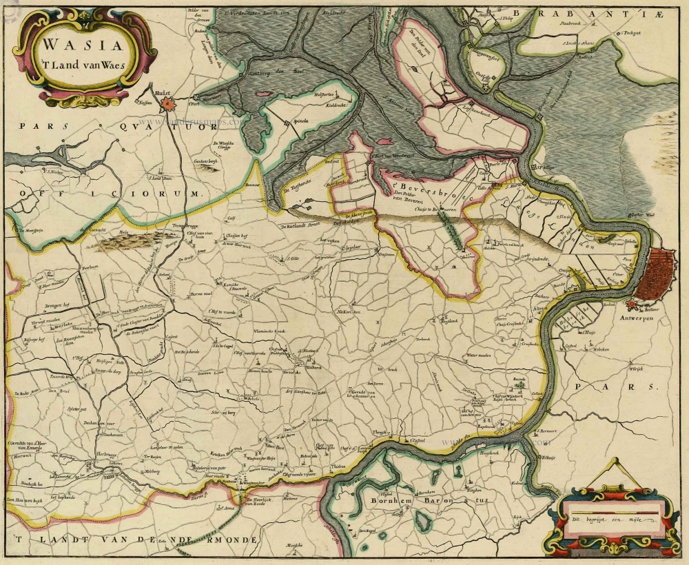
Caerte figuerative van t'Lant van Waes ende Hulster Ambacht als mede de rievier de Schelde met de rechte ghelegentheyt van de naest liggende landen van nieus verbetert.
Item Number: 31253 Authenticity Guarantee
Category: Antique maps > Europe > Belgium
Oost-Vlaanderen - Land van Waes by Pieter Verbiest.
Title: Caerte figuerative van t'Lant van Waes ende Hulster Ambacht als mede de rievier de Schelde met de rechte ghelegentheyt van de naest liggende landen van nieus verbetert.
Door Peeter Verbist Anno 1656.
T'Antwerpen, Gedruckt bij Peeter Verbist op de Lombaerde vest in America.
Date: 1656.
Date on map: 1656.
At the top a stamp of the "Dépôt des Cartes et Plans de la Marine".
Copper engraving, printed on paper.
Image size: 660 x 715mm (25.98 x 28.15 inches).
Sheet size: 670 x 725mm (26.38 x 28.54 inches).
Verso: Blank.
Condition: The map is composed of 5 plates, backed with linen, some traces of use.
Condition Rating: A.
Separate publication.
Pieter Verbiest II (Petrus Verbist) and Isaak Verbiest (Isack Verbist)
Pieter Verbiest (Antwerpen, 1605-1693) was an Antwerp cartographer and engraver. Little is known about his life.
One of his most important works is the Novus Tabularum Geographicorum Belgicae (Antwerp, 1636), a pocket atlas of which two more editions were published later (1644 and 1652). Isaak Verbiest, probably a brother of Pieter, drew and engraved certain maps. Their collaboration also led to the production of two rare world maps.
Pieter Verbiest also published folio maps as separate publications. Koeman describes three editions of a Verbiest Atlas of the Netherlands, published between 1636 and 1652. Only one copy of each of these atlases is known.
Verbiest maps, some with beautiful decorative borders, city views, costumed figures, and coats of arms, were sometimes bound in composite atlases. Occasionally, copies of these scarce maps come onto the market.
Pieter Verbiest II was the son of Pieter Verbiest I (c. 1585-c. 1642), publisher and illuminator of maps in Antwerp.
Related items
Wasia. 't Land van Waes. 1732
Land van Waas by Antonius Sanderus.
[Item number: 20792]

Carte tres-particuliere du Paijs de Waes, ou sont marqués les Lignes depuis Anvers jusques à Gand. 1712
Land van Waas by Eugène Fricx.
[Item number: 29545]

Flandriae Partes duae, quarum altera Proprietata altera Imperialis vulgo dicitur. 1643
Keizerlijk Vlaanderen of Oost Vlaanderen (Imperial Flanders or Eastern Flanders), by Willem Blaeu.
[Item number: 29935]

Wasia. 't Land van Waes. 1644
Land van Waas by Antonius Sanderus.
[Item number: 29997]

Wasia. 't Land van Waes. 1662
Land van Waas by Antonius Sanderus, published by Joan Blaeu.
[Item number: 31255]