
Rhine River Basin by Coronelli V.M. 1691
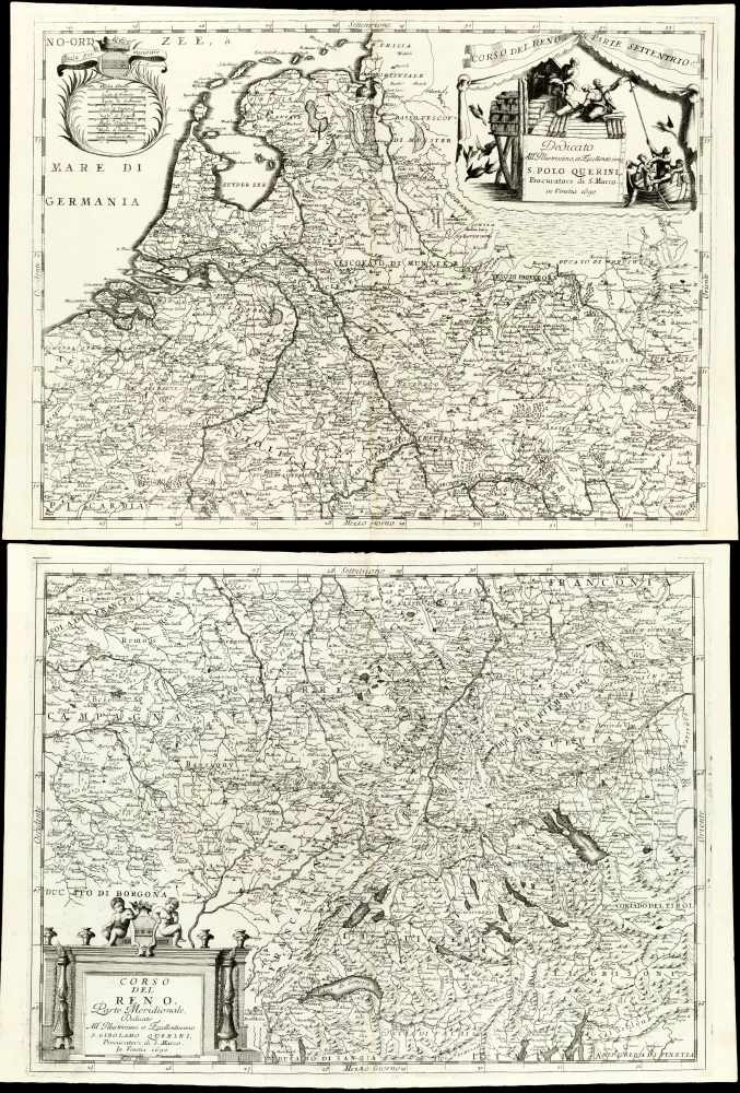
A magnificent and exceptionally detailed two-sheet map of the entire course of the River Rhine, from its sources in the Swiss Alps to its estuary in the North Sea, engraved by the celebrated Venetian cosmographer Vincenzo Maria Coronelli (1650–1718).
The map consists of two large, separately printed sheets that cover the northern and southern sections of the Rhine basin. Together they provide a remarkably comprehensive geographical representation of one of Europe's most important waterways, illustrating the river's course through Switzerland, Germany and the Netherlands, as well as the extensive network of tributaries, towns, principalities and territories along its banks.
The southern sheet, entitled Corso del Reno, Parte Meridionale, extends from the Alpine sources of the Rhine through Switzerland and the Upper Rhine region, including Lake Constance, Basel, Strasbourg and the surrounding territories of Alsace, Baden and the Swiss Confederation. Coronelli renders the intricate network of rivers, mountain ranges, roads, and settlements with characteristic precision and attention to geographical detail.
The northern sheet, Corso del Reno, Parte Settentrionale, continues the river's course through the German territories towards the Dutch Republic and the North Sea. It depicts the complex waterways of the Rhine delta, together with numerous towns, fortified cities, political boundaries and regional divisions. The map also encompasses considerable portions of the surrounding territories, including Westphalia, the Low Countries and neighbouring German states.
Both sheets feature elaborate decorative cartouches. The northern sheet features an especially attractive allegorical composition with putti, architectural elements and maritime imagery, surrounding a dedication to Polo Querini, Procurator of St Mark's in Venice, dated 1690. The southern sheet bears an imposing architectural title cartouche, surmounted by two putti and containing a second dedication to Girolamo Querini, also dated 1690.
The maps are particularly noteworthy for their extraordinary density of geographical information, reflecting Coronelli's ambition to combine scientific cartography with the artistic elegance characteristic of the great Venetian mapmaking tradition.
A superb example of Coronelli's monumental cartography, combining exceptional geographical detail with richly engraved Baroque ornamentation. The two sheets are preserved separately, as issued.
Vincenzo Coronelli (1650-1718)
Vincenzo Coronelli was born in Venice on 16 August 1650 and primarily brought up in Ravenna. He returned to Venice in 1665 and joined the convent of the Minor Conventuals. Five years later, he was sent to Rome to study, and by 1673, he was already a doctor of theology.
Having achieved fame by constructing two globes for the Duke of Parma, he was invited to Paris for three years in 1681 and made two enormous examples for Louis XIV. On his return to Venice, he assiduously collected cartographic material and founded the Academy of the Argonauts. In 1685, he was appointed Cosmographer to the Republic of Venice and authorised to publish a large atlas. He became a geography lecturer at the University of Venice and brought out an Atlante Veneto the following year.
In 1696, he visited Germany, Holland and southern England. During intervals in compiling his vast encyclopaedia, he continued with cartographic projects up to 1709. He died in his native Venice on 9 December 1718.
Coronelli became famous for his globes. In addition, he was a renowned encyclopaedist, mapmaker and geographer. Most of his maps and other material are gathered in his Atlante Veneto (13 vols, 1690-1705). The first volume, subtitled Descrizione generale istorica geografica, was his masterpiece, planned as an extension of Blaeu’s atlas.
Other volumes of the atlas which contain maps are Isolario, two parts (1696-8), with detailed maps and plans, mostly of islands; Corso geografico, two parts based on the edition 1694-7; Libro de’ globi (1697); and Lo Specchio del Mare, a reprint of Levanto's Lo Specchio del Mare Mediterraneo of 1664.
The other vital aspects of his mapping are those arising from the Venetian conquest and his travels. His most extensive military compilation was the Teatro della Guerra, in more than 30 volumes.
Corso del Reno Parte Settentrio [in set with] Corso del Reno Parte Meridionale
Item Number: 33375 new Authenticity Guarantee
Category: Antique maps > Europe > Belgium
Rhine River Basin by Coronelli V.M.
Title: Corso del Reno Parte Settentrio [in set with] Corso del Reno Parte Meridionale
Dedicato All' Illustrissimo, et Eccellentissimo S. Polo Querini Procuratore di S. Marco in Venetia 1690.
Date of the first edition: 1691.
Date of this map: 1691.
Date on map: 1690.
Two copper engravings, printed on two sheets of paper, unjoined.
Image size each: 450 x 600mm (17¾ x 23½ inches).
Sheet size each: 475 x 655mm (18¾ x 25¾ inches).
Verso: Blank.
Condition: Excellent.
Condition Rating: A+.
From: Atlante Veneto, nel quale si contiene la descrittione... degl' Imperii, Regni, Provincie, e Stati dell' Universo. Venice: Girolamo Albrizzi, 1691. Shirley (Brit.Lib.), T.CORO-7a
A magnificent and exceptionally detailed two-sheet map of the entire course of the River Rhine, from its sources in the Swiss Alps to its estuary in the North Sea, engraved by the celebrated Venetian cosmographer Vincenzo Maria Coronelli (1650–1718).
The map consists of two large, separately printed sheets that cover the northern and southern sections of the Rhine basin. Together they provide a remarkably comprehensive geographical representation of one of Europe's most important waterways, illustrating the river's course through Switzerland, Germany and the Netherlands, as well as the extensive network of tributaries, towns, principalities and territories along its banks.
The southern sheet, entitled Corso del Reno, Parte Meridionale, extends from the Alpine sources of the Rhine through Switzerland and the Upper Rhine region, including Lake Constance, Basel, Strasbourg and the surrounding territories of Alsace, Baden and the Swiss Confederation. Coronelli renders the intricate network of rivers, mountain ranges, roads, and settlements with characteristic precision and attention to geographical detail.
The northern sheet, Corso del Reno, Parte Settentrionale, continues the river's course through the German territories towards the Dutch Republic and the North Sea. It depicts the complex waterways of the Rhine delta, together with numerous towns, fortified cities, political boundaries and regional divisions. The map also encompasses considerable portions of the surrounding territories, including Westphalia, the Low Countries and neighbouring German states.
Both sheets feature elaborate decorative cartouches. The northern sheet features an especially attractive allegorical composition with putti, architectural elements and maritime imagery, surrounding a dedication to Polo Querini, Procurator of St Mark's in Venice, dated 1690. The southern sheet bears an imposing architectural title cartouche, surmounted by two putti and containing a second dedication to Girolamo Querini, also dated 1690.
The maps are particularly noteworthy for their extraordinary density of geographical information, reflecting Coronelli's ambition to combine scientific cartography with the artistic elegance characteristic of the great Venetian mapmaking tradition.
A superb example of Coronelli's monumental cartography, combining exceptional geographical detail with richly engraved Baroque ornamentation. The two sheets are preserved separately, as issued.
Vincenzo Coronelli (1650-1718)
Vincenzo Coronelli was born in Venice on 16 August 1650 and primarily brought up in Ravenna. He returned to Venice in 1665 and joined the convent of the Minor Conventuals. Five years later, he was sent to Rome to study, and by 1673, he was already a doctor of theology.
Having achieved fame by constructing two globes for the Duke of Parma, he was invited to Paris for three years in 1681 and made two enormous examples for Louis XIV. On his return to Venice, he assiduously collected cartographic material and founded the Academy of the Argonauts. In 1685, he was appointed Cosmographer to the Republic of Venice and authorised to publish a large atlas. He became a geography lecturer at the University of Venice and brought out an Atlante Veneto the following year.
In 1696, he visited Germany, Holland and southern England. During intervals in compiling his vast encyclopaedia, he continued with cartographic projects up to 1709. He died in his native Venice on 9 December 1718.
Coronelli became famous for his globes. In addition, he was a renowned encyclopaedist, mapmaker and geographer. Most of his maps and other material are gathered in his Atlante Veneto (13 vols, 1690-1705). The first volume, subtitled Descrizione generale istorica geografica, was his masterpiece, planned as an extension of Blaeu’s atlas.
Other volumes of the atlas which contain maps are Isolario, two parts (1696-8), with detailed maps and plans, mostly of islands; Corso geografico, two parts based on the edition 1694-7; Libro de’ globi (1697); and Lo Specchio del Mare, a reprint of Levanto's Lo Specchio del Mare Mediterraneo of 1664.
The other vital aspects of his mapping are those arising from the Venetian conquest and his travels. His most extensive military compilation was the Teatro della Guerra, in more than 30 volumes.
Related items

Scarce
Austrasia ... 1593
The Rhine River, by Gerard de Jode.
[Item number: 5428]

Tractus Rheni et Mosae totusque Vahalis à Rhenoberca Gorcomium usque cum turris adjacentibus ducatus Cliviae regno Noviomagensi et Bommelerwaert. ... 1664-65
Rhine, Waal & Meuse, by J. Blaeu.
[Item number: 12126]

Die ander Tafel des Rheinstroms begreiffens die Pfalz, Westereich, Eyfel ... 1578
The Rhine River, by Münster S.
[Item number: 14630]

Die dritte Tafel des Rheinstroms innhaltend das Nider Teutschlandt 1578
Rhine River, by Münster S.
[Item number: 14633]

Le Cours de la Rivière du Rhein depuis sa Source jusques à son Emboucheure ou sont distingues Toutes les Estats et Souverainetés qui sont dessus et aux environs. ... c. 1700
RHINE RIVER by Schenk P.
[Item number: 19152]

Téâtre de la Guerre sur le Rhein, Moesselle. Mayn, & le Necker, Meuse. Avec les Pais Voisins. 1721-41
The Upper Rhine and surroundings by N. Sanson / Covens & Mortier.
[Item number: 23695]

Circulus Electorum Rheni Sive Rhenanus Inferior ... 1721-41
Rhine River, by Covens & Mortier.
[Item number: 23824]

Rhenus Fluviorum Europae Celeberrimus, cum Mosa, Mosella, et Reliquis, in illum se exonerantibus fluminibus. 1641
Rhine River, by H. Hondius & J. Janssonius.
[Item number: 26281]

Very rare!
Tabula geographica Prouinciarum Brabantiae, Geldriae comitatus Sutphaniae, Traiectini, Transiluaniae; Drentiae, Twentiae, Hollandiae, et Frisiae: ... After 1630
Rhine River by Cornelis Claesz.
[Item number: 27065]
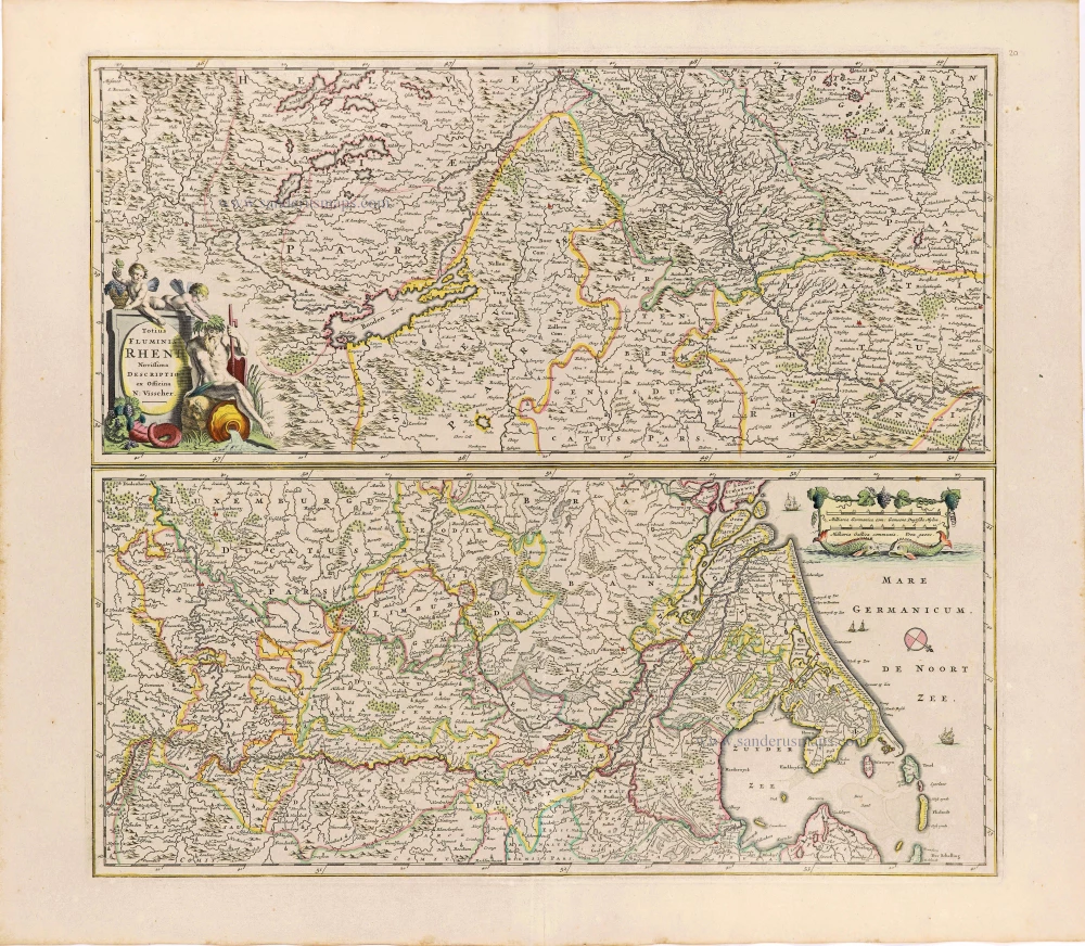
Totius Fluminis Rheni. c. 1664
Rhine River by Nicolaas Visscher I
[Item number: 28619]
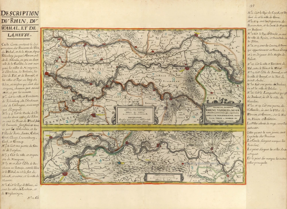
Descriptio Fluminum Rheni, Vahalis et Mosae a Rheno Berca ad Goricomium usque, comprehendens Imperium Noviomagense, Bataviam, Tielae et Bomelii Insulas, regionesque conterminas. c. 1610-1650
Rhine, Waal, and Meuse by Henricus Hondius
[Item number: 31276]

Tabula Geographica qua pars Septentrionalis sive Inferior Rheni, Mosae, et Mosellae, c. 1695
Rhineland, Meuse (river) and Moselle (river) regions, by N. Visscher
[Item number: 33110]

Theatrum Belli Rhenani Auspicatis Militiae Primitiis Potentissimi Roman. et Hunga Regis Iosephi I. Pii Felicis Augusti Landavio Gloriose Expugnato Apertum io. Septemb. Anno MDCCII 1712
Rhine and Moselle Regions by Johann Baptist Homann.
[Item number: 33227]