
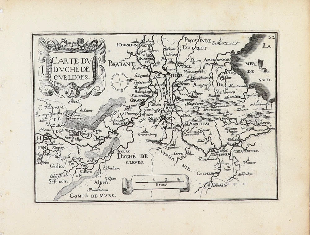
Gelderland by M. Quad 1600


Matthias Quad (Deventer, 1557 – Eppingen, 1613)
Matthias Quad, born in Deventer in 1557, was trained there as an engraver by the Van Deutecum brothers. He also studied with Hendrick Goltzius in Haarlem. Later, he settled in Germany after spending some time in France and England.
He lived in Cologne since 1587, where he met the renowned engraver and mapmaker Frans Hogenberg and the printer and publisher Johann Bussemacher. For the next 15 years, Quad worked closely with Bussemacher, especially in publishing atlases. In 1592, he published a translation of an atlas by Botero, and in the following years, several geographical works followed.
With Bussemacher, he prepared a hand and travel atlas in a small format, for which he primarily focused on engraving. From 1592, they published some editions under the name of Bussemacher without text. In 1594, the Europae … descriptio appeared as an atlas with 50 maps with text by Quad. Bussemacher printed the maps, but the text was printed by Lambert Andreae, with whom Bussemacher often collaborated. In 1600, the Geographisch Handtbuch, a world atlas featuring 82 maps, was published.
From that time on, Quad released a series of Itineraries. The Deliciae Germaniae (1600), the Deliciae Galliae (1600), the Itinearium universae Germaniae (1602), and others on Northern Europe, Italy and Spain.
He spent the last years of his life as a teacher in Eppingen, where he died in 1613.
[No title]
Item Number: 13820 Authenticity Guarantee
Category: Antique maps > Europe > The Netherlands
Old, antique map of Gelderland by M. Quad.
[No title]
Date of the first edition: 1592.
Date of this map: 1600.
Copper engraving, printed on paper.
Size (not including margins): 180 x 265mm (7.09 x 10.43 inches).
Verso: German text.
Condition: Original coloured, excellent.
Condition Rating: A+.
From: Geographisch Handtbuch. Cologne, J. Bussemacher, 1600. (Meurer (Cologne), Qua 6)
Matthias Quad (Deventer, 1557 – Eppingen, 1613)
Matthias Quad, born in Deventer in 1557, was trained there as an engraver by the Van Deutecum brothers. He also studied with Hendrick Goltzius in Haarlem. Later, he settled in Germany after spending some time in France and England.
He lived in Cologne since 1587, where he met the renowned engraver and mapmaker Frans Hogenberg and the printer and publisher Johann Bussemacher. For the next 15 years, Quad worked closely with Bussemacher, especially in publishing atlases. In 1592, he published a translation of an atlas by Botero, and in the following years, several geographical works followed.
With Bussemacher, he prepared a hand and travel atlas in a small format, for which he primarily focused on engraving. From 1592, they published some editions under the name of Bussemacher without text. In 1594, the Europae … descriptio appeared as an atlas with 50 maps with text by Quad. Bussemacher printed the maps, but the text was printed by Lambert Andreae, with whom Bussemacher often collaborated. In 1600, the Geographisch Handtbuch, a world atlas featuring 82 maps, was published.
From that time on, Quad released a series of Itineraries. The Deliciae Germaniae (1600), the Deliciae Galliae (1600), the Itinearium universae Germaniae (1602), and others on Northern Europe, Italy and Spain.
He spent the last years of his life as a teacher in Eppingen, where he died in 1613.
Related items

Scarce
Den Ysel-Stroom van Arnhem tot beneden Deventer met een gedeelte van de Veluwe, c. 1629-1631
Gelderland and Veluwe, by C.J. Visscher.
[Item number: 31221]

Geldria Ducatus et Zutfania Comitatus. c. 1610-1650
Gelderland, by Willem Blaeu.
[Item number: 31223]

La Veluwe, la Betuwe et le comté de Zutphen dans le duché de Gueldre. 1692
Gelderland by N. Sanson, so-called published by Hubert Jaillot. (Pirated edition by Pierre Mortier).
[Item number: 31453]

Geldria et Transisulana. 1607
Gelderland and Overijssel by Gerard Mercator, published by Jodocus Hondius.
[Item number: 31464]

Gueldre Espagnole ou Quartier du Ruremonde dans le Duché de Gueldre. 1692
Gelderland - Roermond by N. Sanson, so-called published by Hubert Jaillot. (Pirated edition by Pierre Mortier).
[Item number: 31466]
Carte du Duché de Gueldres. 1633
Gelderland by Christophe Tassin.
[Item number: 31932]

Very rare
Gueldre Hollandoise avec les Pais, Duchez et Comtez voisins. c. 1690
Gelderland by Nicolas Sanson, published by Pierre Mortier.
[Item number: 32586]