
Overijssel by Ottens R. & J. 1756


The Ottens Family
Joachim Ottens (1663-1719), was a copper-engraver and the founder of the print- and mapsellers’ firm in Amsterdam. In 1710 he became a member of the art- and printsellers guild. After he died in 1719, his widow and the sons continued the business under the name “In de Wereldcaert” (In the world map). On the whole, the Ottens’s financial position was rather weak, and the stock was not very large.
In a notary contract dated 20 October 1726, the partnership between the two brothers, Reinier and Josua, was stipulated. Despite separate shops, the brothers’ partnership continued until the death of Renier in 1750.
After Joshua died in 1765, his widow continued the firm, together with her son, Renier II, until c. 1780.
The firm flourished mainly between 1719 and c. 1750. In that period, they advertised at various times the publication of new maps.
Ottens’s greatest fame comes from the voluminous atlases assembled to order. A small number of these so-called ‘Atlas factice’, splendid copies with gorgeous illumination, have survived. These collector’s copies are known to exist in 2, 6, 8, 11, and even 15 volumes. Ottens also published atlases in one volume, with a varying number of maps, pocket atlases, collections of military plans, and Renard’s atlas de la navigation.
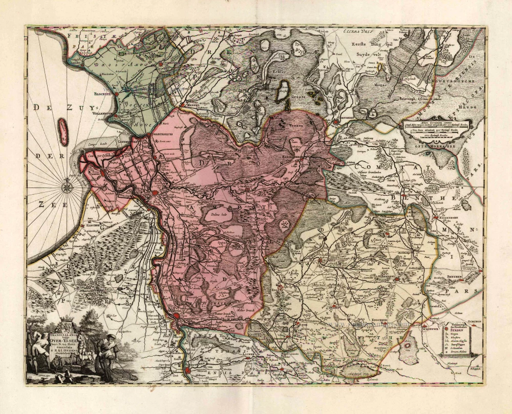
Transisalania Vulgo Over-Yssel.
Item Number: 25793 Authenticity Guarantee
Category: Antique maps > Europe > The Netherlands
Old antique map of Overijssel, by Ottens R. & J..
Title: Transisalania Vulgo Over-Yssel.
Copper engraving, printed on paper.
Size (not including margins): 435 x 550mm (17.13 x 21.65 inches).
Verso: Blank.
Condition: Excellent.
Condition Rating: A+.
From: Atlas minor sive geographia compendiosa in qua orbid terrarum paucis attamen novissimis tablulis ostenditur - Atlas nouveau contenant toutes les parties du monde où sont exactement remarquées les empires, monarchies, royaumes,états, républiques, &c. Amsterdam, R. & J. Ottens (1756). (Koeman, Ott3)
The Ottens Family
Joachim Ottens (1663-1719), was a copper-engraver and the founder of the print- and mapsellers’ firm in Amsterdam. In 1710 he became a member of the art- and printsellers guild. After he died in 1719, his widow and the sons continued the business under the name “In de Wereldcaert” (In the world map). On the whole, the Ottens’s financial position was rather weak, and the stock was not very large.
In a notary contract dated 20 October 1726, the partnership between the two brothers, Reinier and Josua, was stipulated. Despite separate shops, the brothers’ partnership continued until the death of Renier in 1750.
After Joshua died in 1765, his widow continued the firm, together with her son, Renier II, until c. 1780.
The firm flourished mainly between 1719 and c. 1750. In that period, they advertised at various times the publication of new maps.
Ottens’s greatest fame comes from the voluminous atlases assembled to order. A small number of these so-called ‘Atlas factice’, splendid copies with gorgeous illumination, have survived. These collector’s copies are known to exist in 2, 6, 8, 11, and even 15 volumes. Ottens also published atlases in one volume, with a varying number of maps, pocket atlases, collections of military plans, and Renard’s atlas de la navigation.
Related items

L'Over-Issel. 1713
Overijssel, by Pieter Van der Aa.
[Item number: 26063]
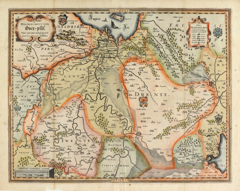
De Heerlyckheyt van Over-Yssel. 1634
Overijssel, by Claes Jansz. Visscher.
[Item number: 28032]

Transisalania Provincia; Vulgo Over-Yssel. 1656-80
Overijssel by Nicolaes Visscher I.
[Item number: 28597]

Transiselania Dominium vernacule Over-Yssel. 1643
Overijssel, by Willem Blaeu.
[Item number: 29949]
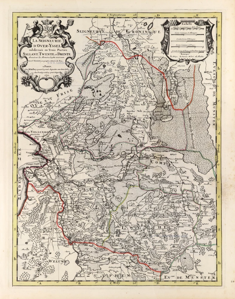
La Seigneurie d'Over-Yssel subdivisée en Trois Parties Sallant, Twente, et Drente. 1692
Utrecht by N. Sanson, so-called published by Hubert Jaillot. (Pirated edition by Pierre Mortier).
[Item number: 31375]

Carte d'Ovver-Yssel. 1633
Overijssel by C. Tassin.
[Item number: 31759]

Ditio Transisulana [with inset view of the town of Deventer:] Deventer [and costume figures:] Transisulani. 1617
Overijssel by Petrus Kaerius (Pieter Van den Keere).
[Item number: 31872]