
's Hertogenbosch, Leuven (Louvain) and Mechelen, by Georg Braun and Frans Hogenberg. 1582

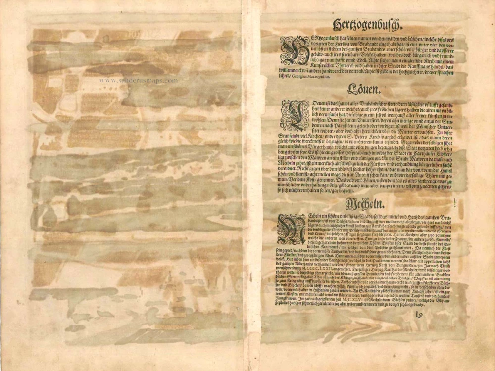

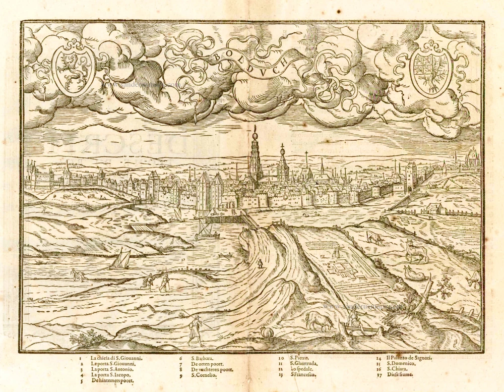
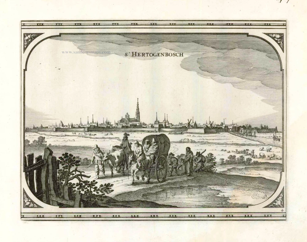
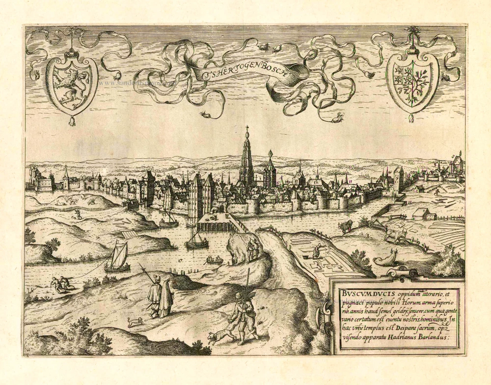
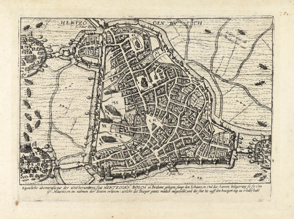
'S-HERTOGENBOSCH
TRANSLATION OF CARTOUCHE TEXT (on verso): The town of 's Hertogenbosch is known for its school and its belligerent populace, who raised their weapons more than once in the past against the people of Guelders. Here stands a magnificent church of Our Lady (Hadrianus Barlandus).
COMMENTARY BY BRAUN: "'s-Hertogenbosch takes its name from the woods and "bushes" that this place formerly possessed at the time of the Duke of Brabant; it is considered one of the four noblest towns in all of Brabant; it has a school, a large number of inhabitants and solid buildings and is considered important and noble on account of its valiant people. There is also a richly decorated church with a splendid clock here."
's-Hertogenbosch was granted a municipal charter in 1185 and in the late Middle Ages it was a market centre for farmers from the surrounding region, who traded here in linen spun from flax and cloth woven from wool. Besides having been a centre of the cloth industry, 's-Hertogenbosch was a distribution point for wine, fish and sandstone, and was of cultural significance: the painter Hieronymus Bosch lived and worked here and the humanist Georgius Macropedius, really Joris van Lanckfelt, was a teacher at the Latin school in 's-Hertogenbosch. Situated on a sandy ridge in the middle of marshes and strongly fortified, this strategically important city was for a long time considered impregnable. The Dutch Revolt in the 16th century put an end to the economic prosperity it enjoyed in the late Middle Ages. (Taschen)
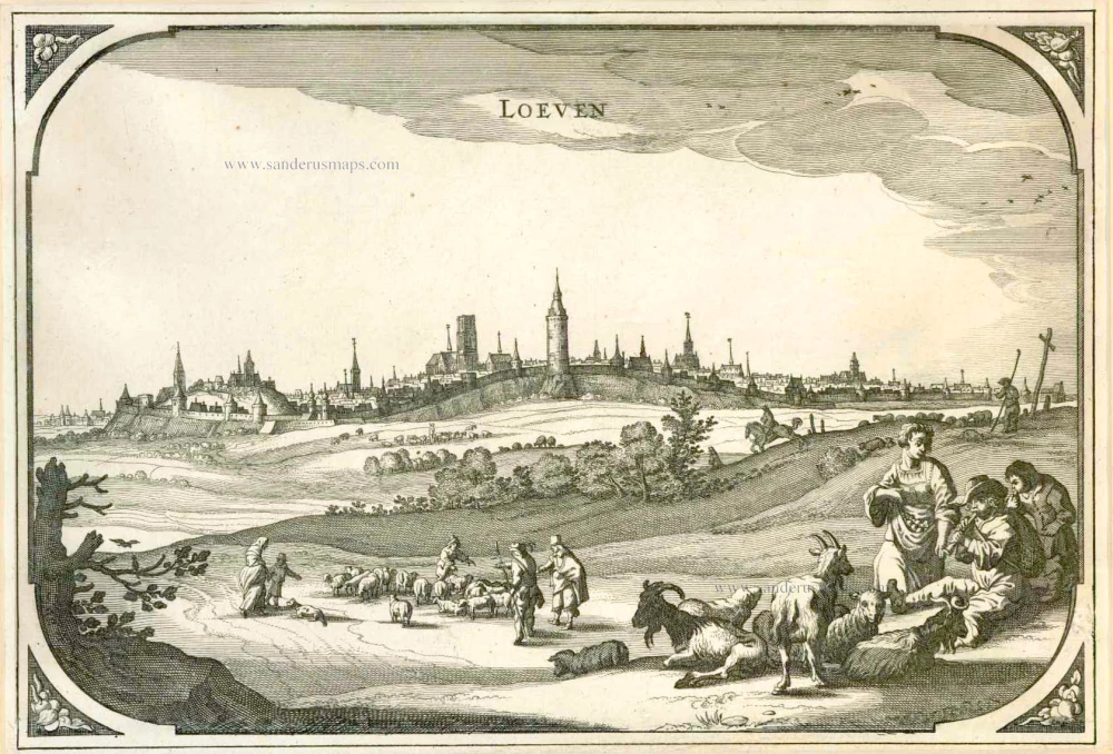
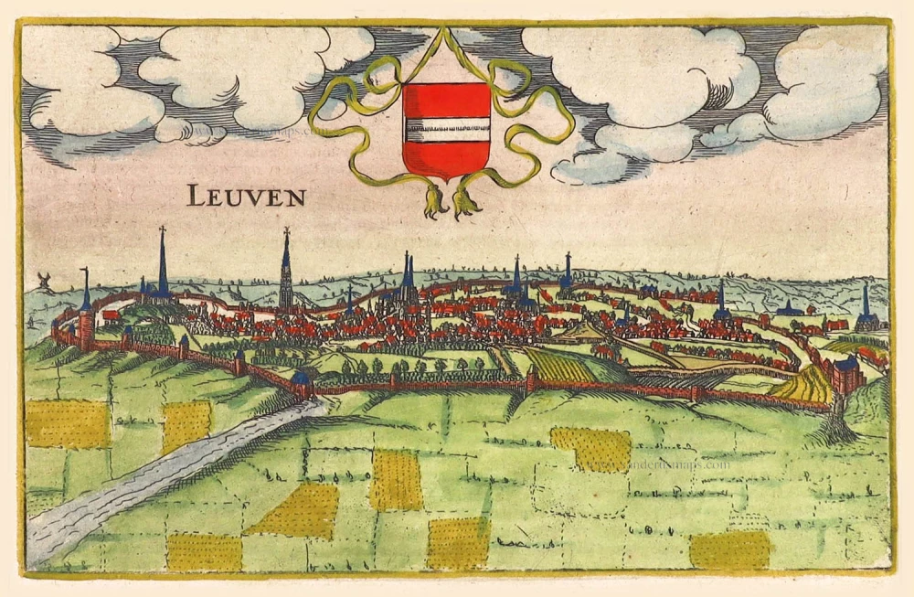
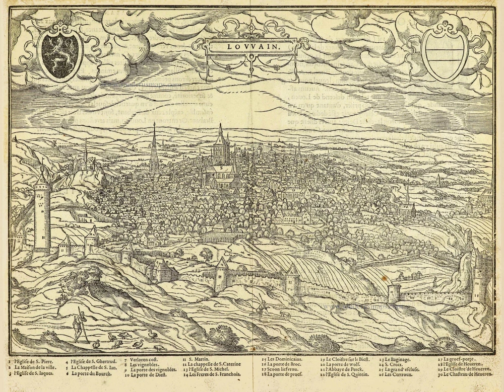
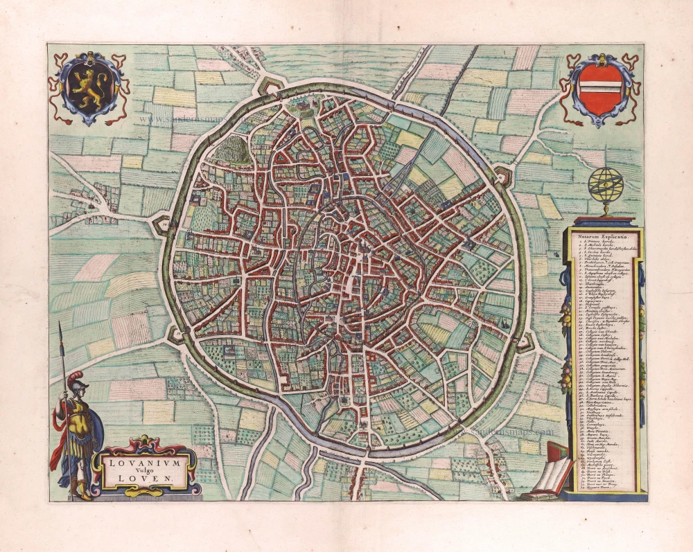
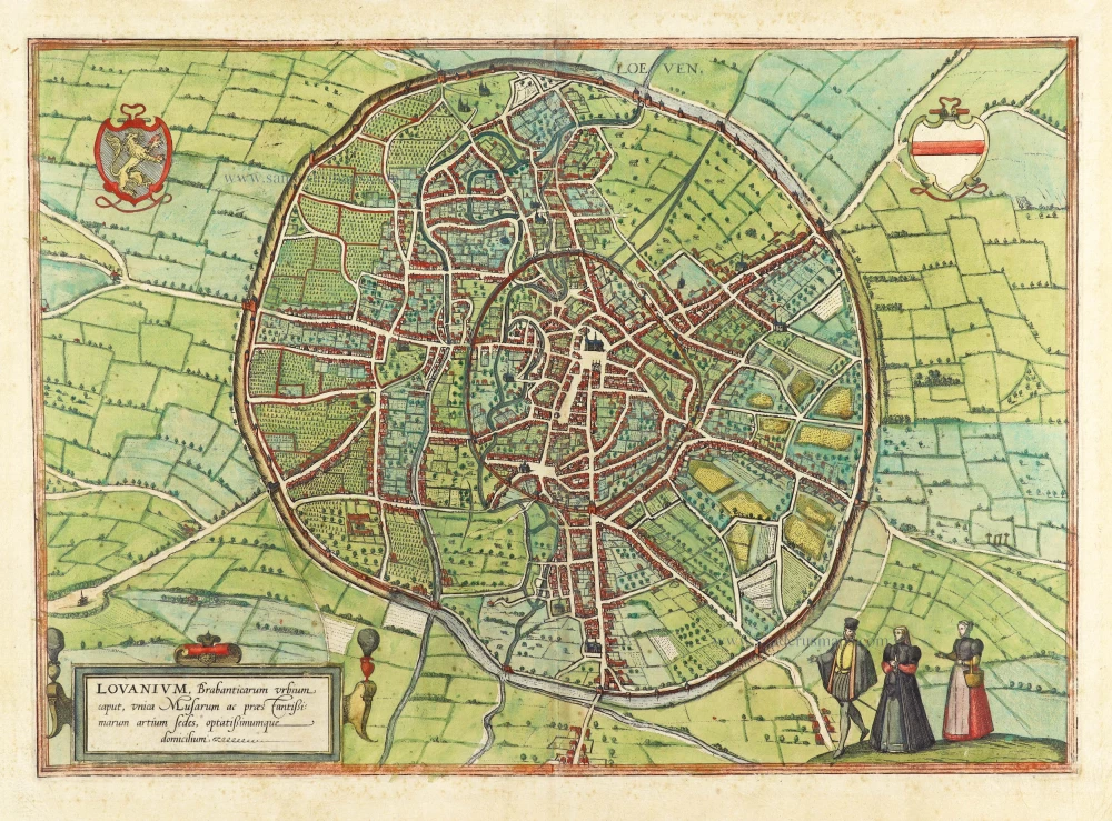
LEUVEN (LOUVAIN)
TRANSLATION OF CARTOUCHE TEXT (on verso): Louvain is a very old city in Brabant, which before Julius Caesar was a small town surrounded by walls and was subsequently expanded to such an extent that the town now has a circumference of four Italian miles. This has been encouraged by the location and good healthy air of the city, which is also notably embellished by the magnificent church of St Peter's, the fine town hall, the very tall school, the plentiful waters of the River Dijle and finally the old castle built by Julius Caesar.
COMMENTARY BY BRAUN (on verso):"Louvain is the capital of Brabant; it possesses a university whose student numbers are no less than Paris; it is a daughter of the University of Cologne, but has grown clearly larger than its mother. Along the rampart in the direction of Mechelen lies a very old castle, which served for the entertainment of the princes and for the administration of the citizens. Opposite it on the right is a castle with a very tall tower, from where on a clear day you can see for eight miles, as far as Antwerp; this tower is commonly known as "Lost Fare"."
This engraving shows the Belgian city of Louvain in side view, set within a hilly landscape and surrounded by an extensive city wall. On a grassy slope on the left stands the castle (Borcht); below it, further left again, the tall viewing tower (Verloren Cost) forms an integral part of the city wall. Other striking features in the cityscape include the unusual tower of Sint-Gertrudis, with its openwork stone steeple, and the church of Sint-Pieters opposite the town hall in the city centre. (Taschen)
The engraving is made after a woodcut in Guicciardini's Descrittione di tutti Paesi Bassi, 1567.
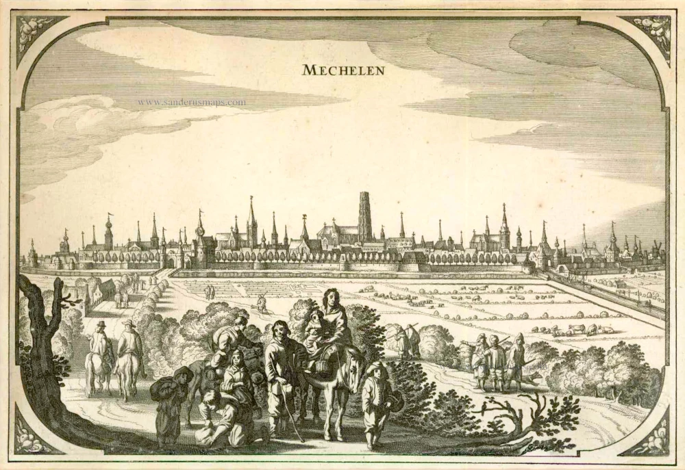
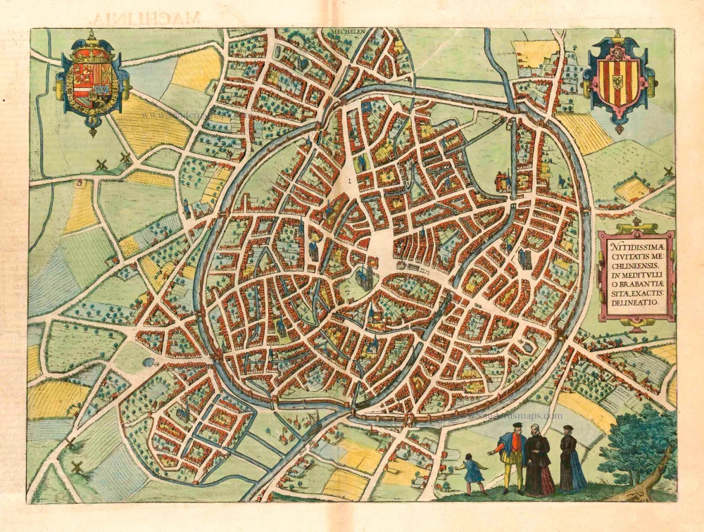
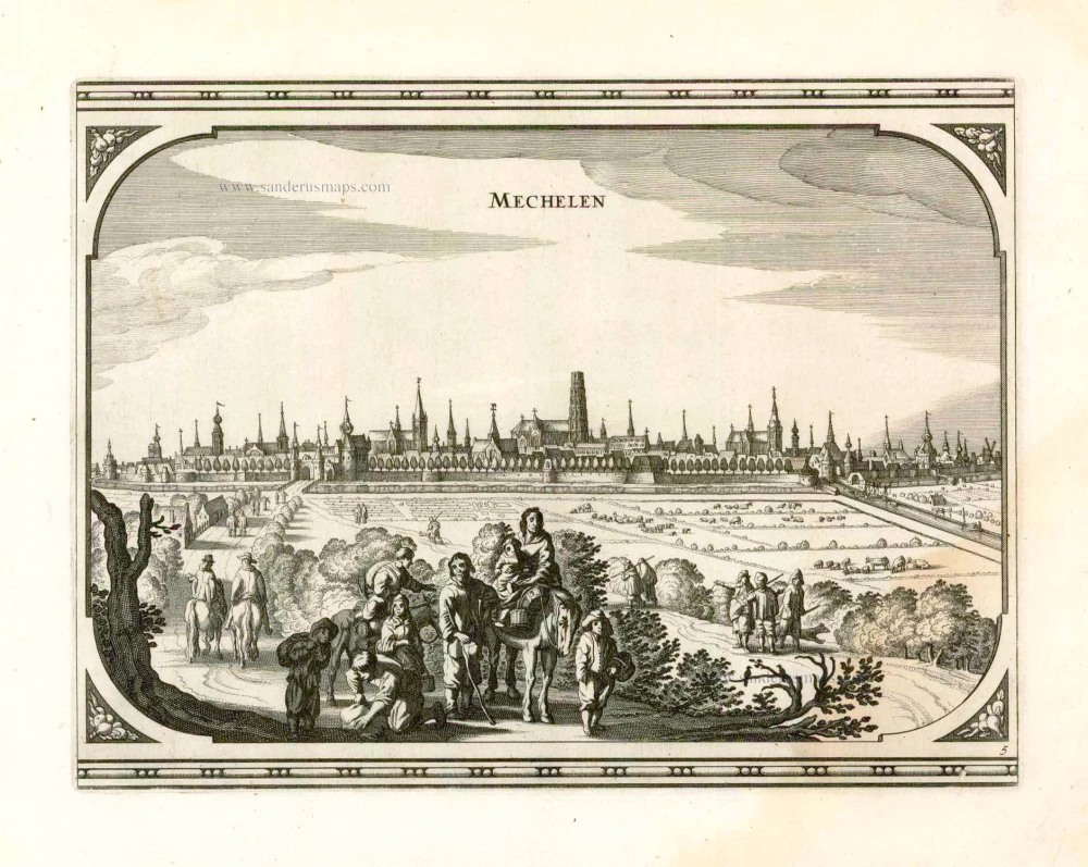
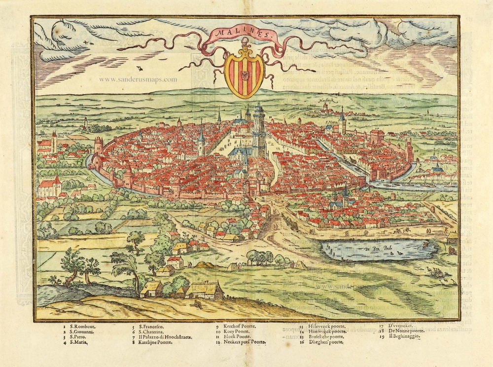
MECHELEN
CARTOUCHE: A very accurate drawing of the handsome city of Mechelen, situated in the middle of Brabant.
COMMENTARY BY BRAUN (on verso):"Mechelen possesses very many churches, including two, however, that surpass the rest: one is the church of Our Lady, the other St Rumold's, which has a very tall and handsome tower. [...] Also located in this city is the royal arsenal, with a simply incredible number of rifles, weapons and all the things that are needed for warfare. In this city there are also very many craftsmen who cast rifles and bells, build ships, make coth, produce skilful paintings and many other things.".
Braun G. & Hogenberg F. and the Civitates Orbis Terrarum.
The Civitates Orbis Terrarum, or the "Braun & Hogenberg", is a six-volume town atlas and the most excellent book of town views and plans ever published: 363 engravings, sometimes beautifully coloured. It was one of the best-selling works in the last quarter of the 16th century. Georg Braun wrote the text accompanying the plans and views on the verso. Many plates were engraved after the original drawings of a professional artist, a professional artist, Joris Hoefnagel (1542-1600). The first volume was published in Latin in 1572, and the sixth in 1617. Frans Hogenberg created the tables for volumes I through IV, and Simon van den Neuwel made those for volumes V and VI. Other contributors were cartographers Daniel Freese and Heinrich Rantzau. Works by Jacob van Deventer, Sebastian Münster, and Johannes Stumpf were also used. Translations appeared in German and French.
Following the original publication of Volume 1 of the Civitates in 1572, seven further editions of 1575, 1577, 1582, 1588, 1593, 1599 and 1612 can be identified. Vol.2, first issued in 1575, was followed by further editions in 1597 and 1612. The subsequent volumes appeared in 1581, 1588, 1593, 1599 and 1606. The German translation of the first volume appeared from 1574 on, and the French edition from 1575 on.
Several printers were involved: Theodor Graminaeus, Heinrich von Aich, Gottfried von Kempen, Johannis Sinniger, Bertram Buchholtz and Peter von Brachel, who all worked in Cologne.
Georg Braun (1541-1622)
Georg Braun was born in Cologne in 1541. After his studies in Cologne, he entered the Jesuit Order as a novice. 1561, he obtained his bachelor's degree, and in 1562, he received his Magister Artium. Although he left the Jesuit Order, he studied theology, gaining a licentiate in theology.
Frans Hogenberg (1535-1590)
Frans Hogenberg was a Flemish and German painter, engraver, and mapmaker. He was born in Mechelen as the son of Nicolaas Hogenberg.
By the end of the 1560s, Frans Hogenberg was employed upon Abraham Ortelius's Theatrum Orbis Terrarum, published in 1570; he is named an engraver of numerous maps. In 1568, he was banned from Antwerp by the Duke of Alva and travelled to London, where he stayed a few years before emigrating to Cologne. He immediately embarked on his two most important works, the Civitates, published in 1572 and the Geschichtsblätter, which appeared in several series from 1569 until about 1587.
Thanks to large-scale projects like the Geschichtsblätter and the Civitates, Hogenberg's social circumstances improved with each passing year. He died as a wealthy man in Cologne in 1590.
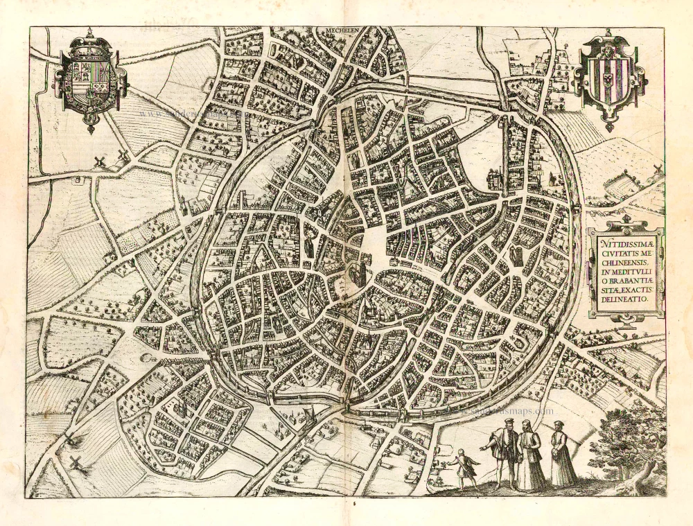
Tshertogenbosch - Buscumducis oppidum ludo Literario, ... [on sheet with] Loeven - Lovanium Perantiqua Brabantiae urbs ... [and] Machelen - Nitidissimae Civitatis Mechlin ...
Item Number: 16669 Authenticity Guarantee
Category: Antique maps > Europe > The Netherlands - Cities
Old, antique bird’s-eye view plan of 's Hertogenbosch, Leuven (Louvain) and Mechelen, by Georg Braun and Frans Hogenberg.
Title: Tshertogenbosch - Buscumducis oppidum ludo Literario, ... [on one sheet with] Loeven - Lovanium Perantiqua Brabantiae urbs ... [and] Machelen - Nitidissimae Civitatis Mechlin ...
Date of the first edition: 1572.
Date of this map: 1582.
Copper engraving, printed on paper.
Size (not including margins): 364 x 480mm (14.33 x 18.9 inches).
Verso: German text.
Condition: Original-coloured, age-toned.
Condition Rating: B.
From: Beschreibung und Contrafactur der vornembster Stät der Welt. [Part 1] Cologne, Gottfried von Kempen, 1582. (Van der Krogt 4, 41:2.1)
'S-HERTOGENBOSCH
TRANSLATION OF CARTOUCHE TEXT (on verso): The town of 's Hertogenbosch is known for its school and its belligerent populace, who raised their weapons more than once in the past against the people of Guelders. Here stands a magnificent church of Our Lady (Hadrianus Barlandus).
COMMENTARY BY BRAUN: "'s-Hertogenbosch takes its name from the woods and "bushes" that this place formerly possessed at the time of the Duke of Brabant; it is considered one of the four noblest towns in all of Brabant; it has a school, a large number of inhabitants and solid buildings and is considered important and noble on account of its valiant people. There is also a richly decorated church with a splendid clock here."
's-Hertogenbosch was granted a municipal charter in 1185 and in the late Middle Ages it was a market centre for farmers from the surrounding region, who traded here in linen spun from flax and cloth woven from wool. Besides having been a centre of the cloth industry, 's-Hertogenbosch was a distribution point for wine, fish and sandstone, and was of cultural significance: the painter Hieronymus Bosch lived and worked here and the humanist Georgius Macropedius, really Joris van Lanckfelt, was a teacher at the Latin school in 's-Hertogenbosch. Situated on a sandy ridge in the middle of marshes and strongly fortified, this strategically important city was for a long time considered impregnable. The Dutch Revolt in the 16th century put an end to the economic prosperity it enjoyed in the late Middle Ages. (Taschen)
LEUVEN (LOUVAIN)
TRANSLATION OF CARTOUCHE TEXT (on verso): Louvain is a very old city in Brabant, which before Julius Caesar was a small town surrounded by walls and was subsequently expanded to such an extent that the town now has a circumference of four Italian miles. This has been encouraged by the location and good healthy air of the city, which is also notably embellished by the magnificent church of St Peter's, the fine town hall, the very tall school, the plentiful waters of the River Dijle and finally the old castle built by Julius Caesar.
COMMENTARY BY BRAUN (on verso):"Louvain is the capital of Brabant; it possesses a university whose student numbers are no less than Paris; it is a daughter of the University of Cologne, but has grown clearly larger than its mother. Along the rampart in the direction of Mechelen lies a very old castle, which served for the entertainment of the princes and for the administration of the citizens. Opposite it on the right is a castle with a very tall tower, from where on a clear day you can see for eight miles, as far as Antwerp; this tower is commonly known as "Lost Fare"."
This engraving shows the Belgian city of Louvain in side view, set within a hilly landscape and surrounded by an extensive city wall. On a grassy slope on the left stands the castle (Borcht); below it, further left again, the tall viewing tower (Verloren Cost) forms an integral part of the city wall. Other striking features in the cityscape include the unusual tower of Sint-Gertrudis, with its openwork stone steeple, and the church of Sint-Pieters opposite the town hall in the city centre. (Taschen)
The engraving is made after a woodcut in Guicciardini's Descrittione di tutti Paesi Bassi, 1567.
MECHELEN
CARTOUCHE: A very accurate drawing of the handsome city of Mechelen, situated in the middle of Brabant.
COMMENTARY BY BRAUN (on verso):"Mechelen possesses very many churches, including two, however, that surpass the rest: one is the church of Our Lady, the other St Rumold's, which has a very tall and handsome tower. [...] Also located in this city is the royal arsenal, with a simply incredible number of rifles, weapons and all the things that are needed for warfare. In this city there are also very many craftsmen who cast rifles and bells, build ships, make coth, produce skilful paintings and many other things.".
Braun G. & Hogenberg F. and the Civitates Orbis Terrarum.
The Civitates Orbis Terrarum, or the "Braun & Hogenberg", is a six-volume town atlas and the most excellent book of town views and plans ever published: 363 engravings, sometimes beautifully coloured. It was one of the best-selling works in the last quarter of the 16th century. Georg Braun wrote the text accompanying the plans and views on the verso. Many plates were engraved after the original drawings of a professional artist, a professional artist, Joris Hoefnagel (1542-1600). The first volume was published in Latin in 1572, and the sixth in 1617. Frans Hogenberg created the tables for volumes I through IV, and Simon van den Neuwel made those for volumes V and VI. Other contributors were cartographers Daniel Freese and Heinrich Rantzau. Works by Jacob van Deventer, Sebastian Münster, and Johannes Stumpf were also used. Translations appeared in German and French.
Following the original publication of Volume 1 of the Civitates in 1572, seven further editions of 1575, 1577, 1582, 1588, 1593, 1599 and 1612 can be identified. Vol.2, first issued in 1575, was followed by further editions in 1597 and 1612. The subsequent volumes appeared in 1581, 1588, 1593, 1599 and 1606. The German translation of the first volume appeared from 1574 on, and the French edition from 1575 on.
Several printers were involved: Theodor Graminaeus, Heinrich von Aich, Gottfried von Kempen, Johannis Sinniger, Bertram Buchholtz and Peter von Brachel, who all worked in Cologne.
Georg Braun (1541-1622)
Georg Braun was born in Cologne in 1541. After his studies in Cologne, he entered the Jesuit Order as a novice. 1561, he obtained his bachelor's degree, and in 1562, he received his Magister Artium. Although he left the Jesuit Order, he studied theology, gaining a licentiate in theology.
Frans Hogenberg (1535-1590)
Frans Hogenberg was a Flemish and German painter, engraver, and mapmaker. He was born in Mechelen as the son of Nicolaas Hogenberg.
By the end of the 1560s, Frans Hogenberg was employed upon Abraham Ortelius's Theatrum Orbis Terrarum, published in 1570; he is named an engraver of numerous maps. In 1568, he was banned from Antwerp by the Duke of Alva and travelled to London, where he stayed a few years before emigrating to Cologne. He immediately embarked on his two most important works, the Civitates, published in 1572 and the Geschichtsblätter, which appeared in several series from 1569 until about 1587.
Thanks to large-scale projects like the Geschichtsblätter and the Civitates, Hogenberg's social circumstances improved with each passing year. He died as a wealthy man in Cologne in 1590.
Related items
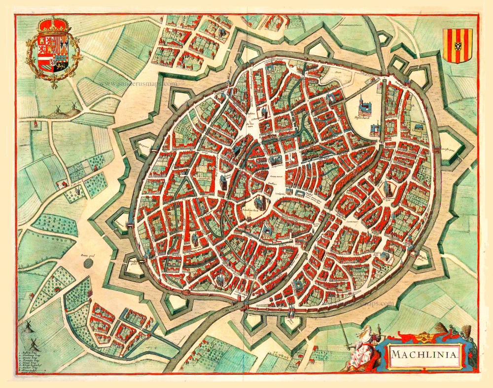
Machlinia. 1652
Mechelen, by Joan Blaeu.
[Item number: 3780]
Mecheln 1726
Mechelen by D. Fassmann
[Item number: 5948]
Mechelen 1656
Old, antique map - panoramic view of Mechelen by N. Visscher & P.H. Schut
[Item number: 6992]
Loeven. 1656
Leuven, by N. Visscher & P.H. Schut.
[Item number: 6995]
Mechelen - Nitidissimae Civitatis Mechlineensis in meditullio Brabantiae sitae, exactis: delineatio. 1582
Mechelen, by Georg Braun & Frans Hogenberg.
[Item number: 14483]
Leuven. 1613
Leuven by Ludovico Guicciardini.
[Item number: 16739]
Mechelen - Nitidissimae Civitatis Mechlineensis in meditullio Brabantiae sitae, exactis: delineatio 1581-88
Mechelen, by Braun & Hogenberg.
[Item number: 18002]

Löven. 1659
Leuven (Louvain) by Merian C.
[Item number: 18393]
First edition
Bolduch. 1567
's-Hertogenbosch by L. Guicciardini
[Item number: 25198]
s' Hertogenbosch. 1656
's-Hertogenbosch by Visscher N. - Schut P.H.
[Item number: 25370]
Mechelen. 1656
Mechelen by Visscher N. - Schut P.H.
[Item number: 25372]
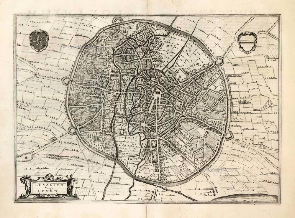
Lovanium vulgo Loven. 1657
Leuven by J. Janssonius.
[Item number: 25892]
Tshertogenbosch. 1609
's-Hertogenbosch by L. Guicciardini
[Item number: 25909]
Louvain. 1567
Leuven (Louvain) by Ludovico Guicciardini.
[Item number: 28305]
Malines. 1567
Mechelen by Lodovico Guicciardini.
[Item number: 29158]
Lovanium vulgo Loven. 1649
Leuven by Joan Blaeu.
[Item number: 29726]
A print of the 'Geschichtsblätter'
Hertzogen Busch - Eigentliche abcontrafactur der weitberumbten stat Hertzogen Bosch in Brabant gelegen, 1601-1612
Siege of s' Hertogenbosch by Maurice of Orange, published by Frans Hogenberg (Atelier)..
[Item number: 29947]
Important plan.
Loeven - Lovanium, Brabanticarum urbium caput, unica Musarum ac praestantissimorum artium sedes, optatissimimque domicilium. 1599
Louvain by Georg Braun & Frans Hogenberg.
[Item number: 29977]