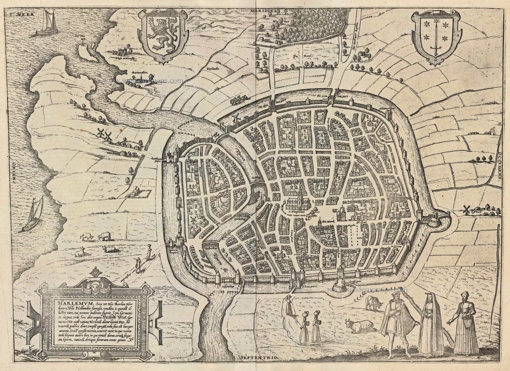
Old antique plan of Haarlem by Georg Braun & Frans Hogenberg 1623
The item displayed on this page has been sold. However, we have a similar map in stock:
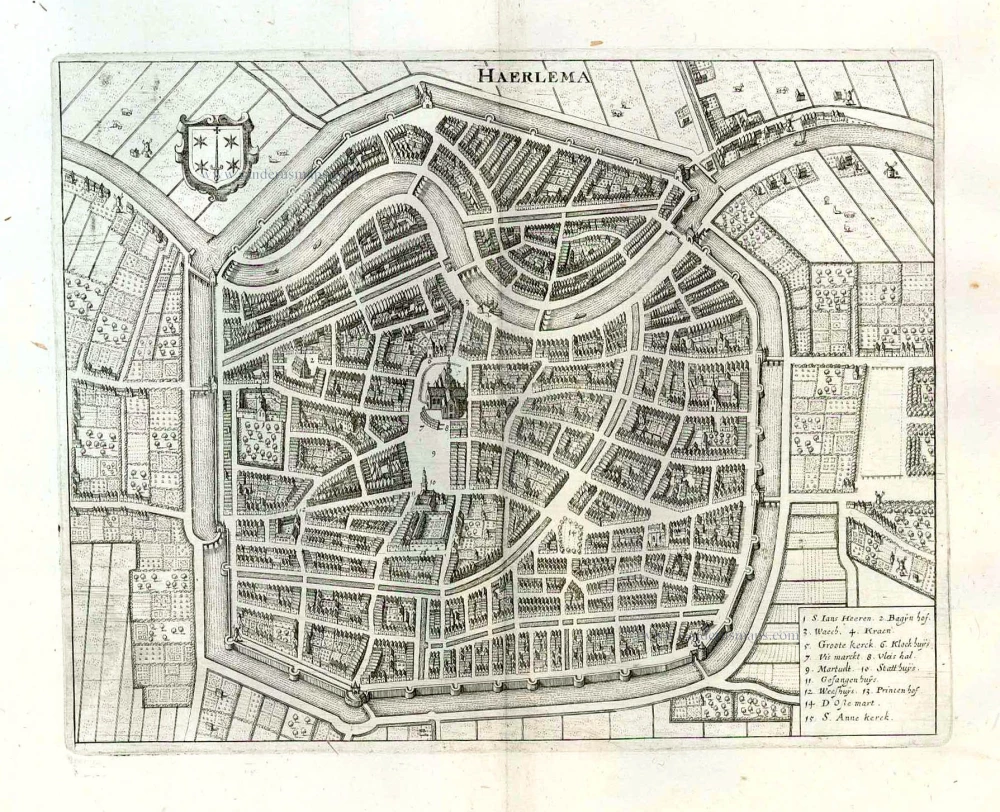
Haarlem, by Georg Braun and Franz Hogenberg. 1576
Harlemum, Sive ut Ha: Barlan Herlemum, Urbs ...
[Item number: 31817]
new
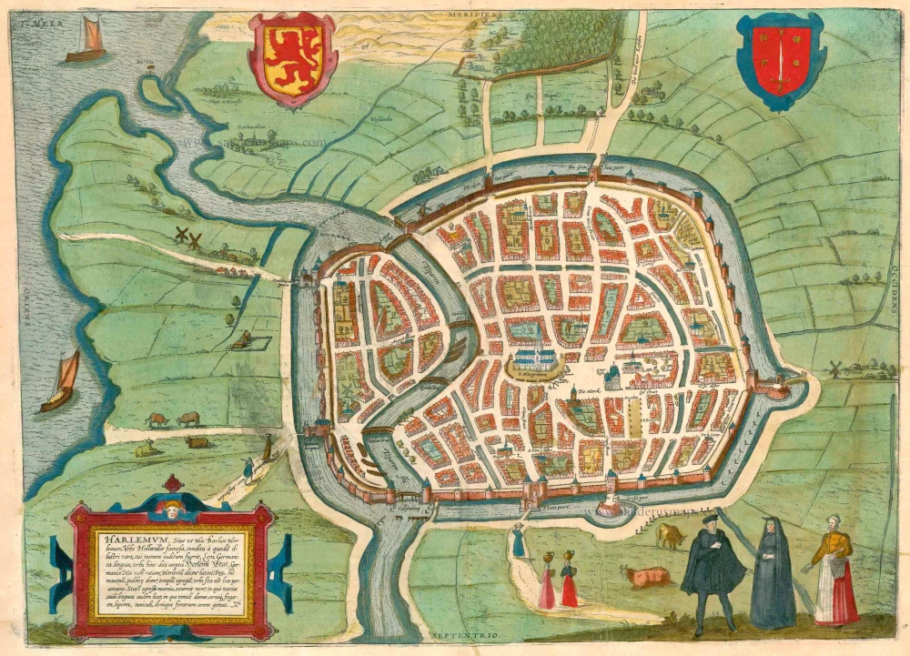


TRANSLATION OF CARTOUCHE TEXT: Harlemum, or, as Hadrianus Barlandus writes, Herlemum, a renowned Dutch city founded by an illustrious man who had the German name Lem; the town was therefore called Herr-Lems-Stadt in German. We say Harlemum in Latin, with the same meaning. There is a great market square, beautiful houses, and an admirable church. The city is a charming location. Immediately after leaving the walls behind, one enters a grove where various bird songs can be heard and where timid deer live, fleeing stags, hares, rabbits, in short, all manner of wild animals.
COMMENTARY BY BRAUN: "The art of book printing is said to have been invented in Haarlem, as attested by various sources. But the first inventor of this art died before he had assembled all the things he needed for printing. His servant then travelled to Mainz and began to practise the newly invented art there."
Haarlem, a trade city whose favourable position on the coast is shown in a bird's-eye view from the southeast, was experiencing a tremendous economic and demographic upturn at the time of the publication of this engraving, following the Agreement of Veere in 1577, when it was returned to the House of Orange. Around 1573, the population was approximately 18,000, which had risen to 40,000 by 1622. Many Flemings came here to escape Spanish occupation and to take advantage of the flourishing textile industry. After a devastating fire laid by the Spanish had destroyed almost 500 buildings, the architect Lieven de Key planned much of the reconstruction work. The tulip trade also flourished in Haarlem in the 17th century. The three-nave Sint-Baafskerk, with its wooden tower and the town hall, can still be seen in the Grote Markt today. Here stands a bronze statue of Laurens Coster, who, according to a local legend, invented the art of book printing in 1423.
This engraving is made after a map by Jacob van Deventer. (Taschen)
Braun G. & Hogenberg F. and the Civitates Orbis Terrarum.
The Civitates Orbis Terrarum, also known as the 'Braun & Hogenberg', is a six-volume town atlas and the most excellent book of town views and plans ever published: 363 engravings, sometimes beautifully coloured. It was one of the best-selling works in the last quarter of the 16th century. Georg Braun, a skilled writer, wrote the text accompanying the plans and views on the verso. Many plates were engraved after the original drawings of a professional artist, Joris Hoefnagel (1542-1600). The first volume was published in Latin in 1572 and the sixth in 1617. Frans Hogenberg, a talented engraver, created the tables for volumes I through IV, and Simon van den Neuwel made those for volumes V and VI. Other contributors were cartographers Daniel Freese and Heinrich Rantzau, who provided valuable geographical information. Works by Jacob van Deventer, Sebastian Münster, and Johannes Stumpf were also used as references. Translations appeared in German and French, making the atlas accessible to a broader audience.
Since its original publication of volume 1 in 1572, the Civitates Orbis Terrarum has left an indelible mark on the history of cartography. Seven more editions followed the first volume in 1575, 1577, 1582, 1588, 1593, 1599, and 1612. Vol.2, initially released in 1575, saw subsequent editions in 1597 and 1612. The subsequent volumes, each a treasure trove of historical insights, graced the world in 1581, 1588, 1593, 1599, and 1606. The German translation of the first volume, a testament to its widespread appeal, debuted in 1574, followed by the French edition in 1575.
Several printers were involved: Theodor Graminaeus, Heinrich von Aich, Gottfried von Kempen, Johannis Sinniger, Bertram Buchholtz, and Peter von Brachel, all of whom worked in Cologne.
Georg Braun (1541-1622)
Georg Braun, the author of the text accompanying the plans and views in the Civitates Orbis Terrarum, was born in Cologne in 1541. After his studies in Cologne, he entered the Jesuit Order as a novice, indicating his commitment to learning and intellectual pursuits. In 1561, he obtained his bachelor's degree; in 1562, he received his Magister Artium, further demonstrating his academic achievements. Although he left the Jesuit Order, he continued his studies in theology, gaining a licentiate in theology. His theological background likely influenced the content and tone of the text in the Civitates Orbis Terrarum, adding a unique perspective to the work.
Frans Hogenberg (1535-1590)
Frans Hogenberg was a Flemish and German painter, engraver, and mapmaker. He was born in Mechelen as the son of Nicolaas Hogenberg.
By the end of the 1560s, Frans Hogenberg was employed upon Abraham Ortelius's Theatrum Orbis Terrarum, published in 1570; he is named an engraver of numerous maps. In 1568, he was banned from Antwerp by the Duke of Alva and travelled to London, where he stayed a few years before emigrating to Cologne. He immediately embarked on his two most important works, the Civitates, published in 1572 and the Geschichtsblätter, which appeared in several series from 1569 until about 1587.
Thanks to large-scale projects like the Geschichtsblätter and the Civitates, Hogenberg's social circumstances improved with each passing year. He died as a wealthy man in Cologne in 1590.
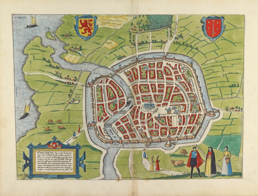
Harlemum, Sive ut Ha: Barlan Herlemum, Urbs Hollandiae famosa, ...
Item Number: 23266 Authenticity Guarantee
Category: Antique maps > Europe > The Netherlands - Cities
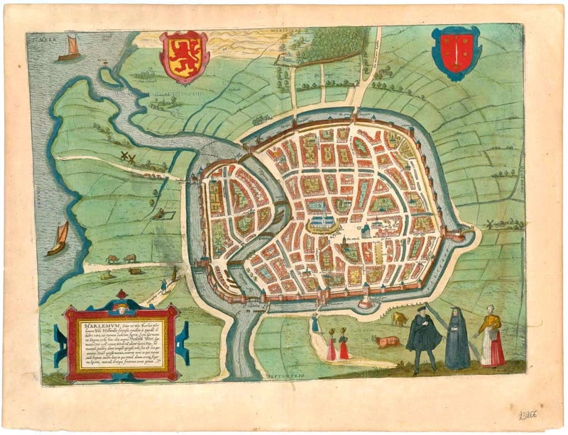
Old, antique bird's-eye view plan of Haarlem, by Georg Braun and Frans Hogenberg.
Title: Harlemum, Sive ut Ha: Barlan Herlemum, Urbs Hollandiae famosa, ...
Cartographer: Jacob van Deventer.
Date of the first edition: 1575.
Date of this map: 1623.
Copper engraving, printed on paper.
Map size: 340 x 470mm (13.39 x 18.5 inches).
Sheet size: 410 x 540mm (16.14 x 21.26 inches).
Verso: Latin text.
Condition: Some minor smudging, nice old colour.
Condition Rating: A.
From: Civitates Orbis Terrarum, ... Part 2: De Praecipuis, Totius Universi Urbibus, Liber Secundus. Köln, Petrus von Brachel, 1623. (Van der Krogt 4, 41:1.2)
TRANSLATION OF CARTOUCHE TEXT: Harlemum, or, as Hadrianus Barlandus writes, Herlemum, a renowned Dutch city founded by an illustrious man who had the German name Lem; the town was therefore called Herr-Lems-Stadt in German. We say Harlemum in Latin, with the same meaning. There is a great market square, beautiful houses, and an admirable church. The city is a charming location. Immediately after leaving the walls behind, one enters a grove where various bird songs can be heard and where timid deer live, fleeing stags, hares, rabbits, in short, all manner of wild animals.
COMMENTARY BY BRAUN: "The art of book printing is said to have been invented in Haarlem, as attested by various sources. But the first inventor of this art died before he had assembled all the things he needed for printing. His servant then travelled to Mainz and began to practise the newly invented art there."
Haarlem, a trade city whose favourable position on the coast is shown in a bird's-eye view from the southeast, was experiencing a tremendous economic and demographic upturn at the time of the publication of this engraving, following the Agreement of Veere in 1577, when it was returned to the House of Orange. Around 1573, the population was approximately 18,000, which had risen to 40,000 by 1622. Many Flemings came here to escape Spanish occupation and to take advantage of the flourishing textile industry. After a devastating fire laid by the Spanish had destroyed almost 500 buildings, the architect Lieven de Key planned much of the reconstruction work. The tulip trade also flourished in Haarlem in the 17th century. The three-nave Sint-Baafskerk, with its wooden tower and the town hall, can still be seen in the Grote Markt today. Here stands a bronze statue of Laurens Coster, who, according to a local legend, invented the art of book printing in 1423.
This engraving is made after a map by Jacob van Deventer. (Taschen)
Braun G. & Hogenberg F. and the Civitates Orbis Terrarum.
The Civitates Orbis Terrarum, also known as the 'Braun & Hogenberg', is a six-volume town atlas and the most excellent book of town views and plans ever published: 363 engravings, sometimes beautifully coloured. It was one of the best-selling works in the last quarter of the 16th century. Georg Braun, a skilled writer, wrote the text accompanying the plans and views on the verso. Many plates were engraved after the original drawings of a professional artist, Joris Hoefnagel (1542-1600). The first volume was published in Latin in 1572 and the sixth in 1617. Frans Hogenberg, a talented engraver, created the tables for volumes I through IV, and Simon van den Neuwel made those for volumes V and VI. Other contributors were cartographers Daniel Freese and Heinrich Rantzau, who provided valuable geographical information. Works by Jacob van Deventer, Sebastian Münster, and Johannes Stumpf were also used as references. Translations appeared in German and French, making the atlas accessible to a broader audience.
Since its original publication of volume 1 in 1572, the Civitates Orbis Terrarum has left an indelible mark on the history of cartography. Seven more editions followed the first volume in 1575, 1577, 1582, 1588, 1593, 1599, and 1612. Vol.2, initially released in 1575, saw subsequent editions in 1597 and 1612. The subsequent volumes, each a treasure trove of historical insights, graced the world in 1581, 1588, 1593, 1599, and 1606. The German translation of the first volume, a testament to its widespread appeal, debuted in 1574, followed by the French edition in 1575.
Several printers were involved: Theodor Graminaeus, Heinrich von Aich, Gottfried von Kempen, Johannis Sinniger, Bertram Buchholtz, and Peter von Brachel, all of whom worked in Cologne.
Georg Braun (1541-1622)
Georg Braun, the author of the text accompanying the plans and views in the Civitates Orbis Terrarum, was born in Cologne in 1541. After his studies in Cologne, he entered the Jesuit Order as a novice, indicating his commitment to learning and intellectual pursuits. In 1561, he obtained his bachelor's degree; in 1562, he received his Magister Artium, further demonstrating his academic achievements. Although he left the Jesuit Order, he continued his studies in theology, gaining a licentiate in theology. His theological background likely influenced the content and tone of the text in the Civitates Orbis Terrarum, adding a unique perspective to the work.
Frans Hogenberg (1535-1590)
Frans Hogenberg was a Flemish and German painter, engraver, and mapmaker. He was born in Mechelen as the son of Nicolaas Hogenberg.
By the end of the 1560s, Frans Hogenberg was employed upon Abraham Ortelius's Theatrum Orbis Terrarum, published in 1570; he is named an engraver of numerous maps. In 1568, he was banned from Antwerp by the Duke of Alva and travelled to London, where he stayed a few years before emigrating to Cologne. He immediately embarked on his two most important works, the Civitates, published in 1572 and the Geschichtsblätter, which appeared in several series from 1569 until about 1587.
Thanks to large-scale projects like the Geschichtsblätter and the Civitates, Hogenberg's social circumstances improved with each passing year. He died as a wealthy man in Cologne in 1590.