
Kolding, by Georg Braun and Frans Hogenberg. c. 1610

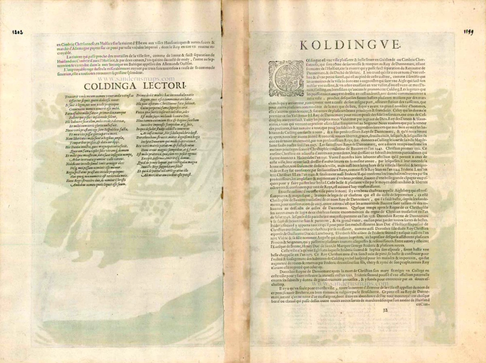
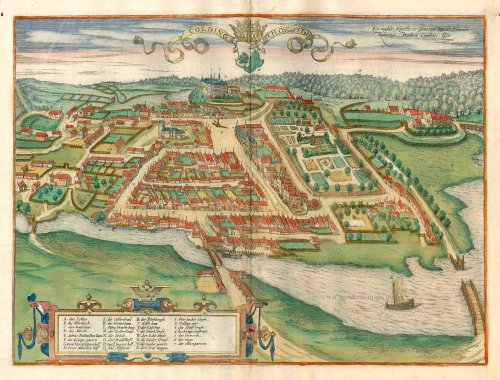
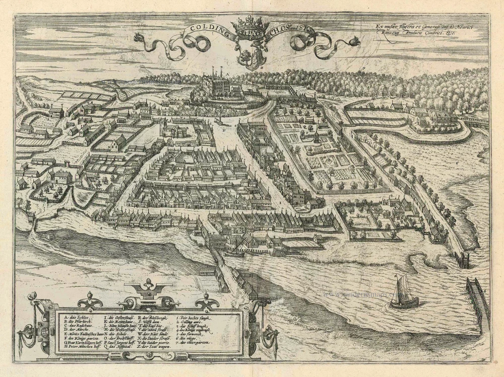
COMMENTARY BY BRAUN (on verso): "Kolding is a very old and charmingly situated little town with a castle in Denmark [...] that lies on the border between the Kingdom of Denmark and the Duchy of Schleswig. [...] The town started out as a few fishermen's huts; over the course of time, these were joined by houses built by merchants, who settled here on account of the excellent harbour and easy access to the sea and whose numbers so increased that eventually a municipality formed with its own charter and civic rights. On the hill from which the little town takes its name lies a castle called Adlerburg, which can be easily seen from a great distance."
The port of Kolding on the Danish Jutland Peninsula is seen from a cavalier perspective from the south. The shore of Kolding Fjord can be seen on the right-hand edge of the picture, and in the background is the royal palace of Koldinghus (A), which dates back to the mid-13th century and was originally built as a fortress to defend the border. Kolding sprang up in the 12th century as a trading centre with sheltered access to the sea. With the separation of the neighbouring Duchy of Schleswig from the Kingdom of Denmark in the 13th century, Kolding assumed greater importance as a frontier town and, in 1321, was finally granted its charter. Koldinghus palace was frequently inhabited by the Danish royal family in the Middle Ages before Copenhagen was finally established as the central royal residence in 1417. Kolding itself was long overshadowed by the neighbouring town of Haderslev and later by Fredericia.
The engraving is made after a drawing provided by Heinrich Rantzau. In Braun's text, explicit mention is made of the fact that the view came from the study of the produx cimbricus, i.e. Rantzau. (Taschen)
Braun G. & Hogenberg F. and the Civitates Orbis Terrarum.
The Civitates Orbis Terrarum, also known as the 'Braun & Hogenberg', is a six-volume town atlas and the most excellent book of town views and plans ever published: 363 engravings, sometimes beautifully coloured. It was one of the best-selling works in the last quarter of the 16th century. Georg Braun, a skilled writer, wrote the text accompanying the plans and views on the verso. Many plates were engraved after the original drawings of a professional artist, Joris Hoefnagel (1542-1600). The first volume was published in Latin in 1572 and the sixth in 1617. Frans Hogenberg, a talented engraver, created the tables for volumes I through IV, and Simon van den Neuwel made those for volumes V and VI. Other contributors were cartographers Daniel Freese and Heinrich Rantzau, who provided valuable geographical information. Works by Jacob van Deventer, Sebastian Münster, and Johannes Stumpf were also used as references. Translations appeared in German and French, making the atlas accessible to a broader audience.
Since its original publication of volume 1 in 1572, the Civitates Orbis Terrarum has left an indelible mark on the history of cartography. Seven more editions followed the first volume in 1575, 1577, 1582, 1588, 1593, 1599, and 1612. Vol.2, initially released in 1575, saw subsequent editions in 1597 and 1612. The subsequent volumes, each a treasure trove of historical insights, graced the world in 1581, 1588, 1593, 1599, and 1606. The German translation of the first volume, a testament to its widespread appeal, debuted in 1574, followed by the French edition in 1575.
Several printers were involved: Theodor Graminaeus, Heinrich von Aich, Gottfried von Kempen, Johannis Sinniger, Bertram Buchholtz, and Peter von Brachel, all of whom worked in Cologne.
Georg Braun (1541-1622)
Georg Braun, the author of the text accompanying the plans and views in the Civitates Orbis Terrarum, was born in Cologne in 1541. After his studies in Cologne, he entered the Jesuit Order as a novice, indicating his commitment to learning and intellectual pursuits. In 1561, he obtained his bachelor's degree; in 1562, he received his Magister Artium, further demonstrating his academic achievements. Although he left the Jesuit Order, he continued his studies in theology, gaining a licentiate in theology. His theological background likely influenced the content and tone of the text in the Civitates Orbis Terrarum, adding a unique perspective to the work.
Frans Hogenberg (1535-1590)
Frans Hogenberg was a Flemish and German painter, engraver, and mapmaker. He was born in Mechelen as the son of Nicolaas Hogenberg.
By the end of the 1560s, Frans Hogenberg was employed upon Abraham Ortelius's Theatrum Orbis Terrarum, published in 1570; he is named an engraver of numerous maps. In 1568, he was banned from Antwerp by the Duke of Alva and travelled to London, where he stayed a few years before emigrating to Cologne. He immediately embarked on his two most important works, the Civitates, published in 1572 and the Geschichtsblätter, which appeared in several series from 1569 until about 1587.
Thanks to large-scale projects like the Geschichtsblätter and the Civitates, Hogenberg's social circumstances improved with each passing year. He died as a wealthy man in Cologne in 1590.
Colding Schloss und Stat
Item Number: 16693 Authenticity Guarantee
Category: Antique maps > Europe > Northern Europe
Old, antique bird’s-eye view plan of Kolding, by Georg Braun and Frans Hogenberg.
Title: Colding Schloss und Stat.
Date of the first edition: 1696.
Date of this map: c. 1610.
Copper engraving, printed on paper.
Size (not including margins): 355 x 480mm (13.98 x 18.9 inches).
Verso: French text.
Condition: Original coloured, excellent.
Condition Rating: A+.
From: Théâtre des Principales Villes de tout l'Univers. Tome 5. c. 1610.
COMMENTARY BY BRAUN (on verso): "Kolding is a very old and charmingly situated little town with a castle in Denmark [...] that lies on the border between the Kingdom of Denmark and the Duchy of Schleswig. [...] The town started out as a few fishermen's huts; over the course of time, these were joined by houses built by merchants, who settled here on account of the excellent harbour and easy access to the sea and whose numbers so increased that eventually a municipality formed with its own charter and civic rights. On the hill from which the little town takes its name lies a castle called Adlerburg, which can be easily seen from a great distance."
The port of Kolding on the Danish Jutland Peninsula is seen from a cavalier perspective from the south. The shore of Kolding Fjord can be seen on the right-hand edge of the picture, and in the background is the royal palace of Koldinghus (A), which dates back to the mid-13th century and was originally built as a fortress to defend the border. Kolding sprang up in the 12th century as a trading centre with sheltered access to the sea. With the separation of the neighbouring Duchy of Schleswig from the Kingdom of Denmark in the 13th century, Kolding assumed greater importance as a frontier town and, in 1321, was finally granted its charter. Koldinghus palace was frequently inhabited by the Danish royal family in the Middle Ages before Copenhagen was finally established as the central royal residence in 1417. Kolding itself was long overshadowed by the neighbouring town of Haderslev and later by Fredericia.
The engraving is made after a drawing provided by Heinrich Rantzau. In Braun's text, explicit mention is made of the fact that the view came from the study of the produx cimbricus, i.e. Rantzau. (Taschen)
Braun G. & Hogenberg F. and the Civitates Orbis Terrarum.
The Civitates Orbis Terrarum, also known as the 'Braun & Hogenberg', is a six-volume town atlas and the most excellent book of town views and plans ever published: 363 engravings, sometimes beautifully coloured. It was one of the best-selling works in the last quarter of the 16th century. Georg Braun, a skilled writer, wrote the text accompanying the plans and views on the verso. Many plates were engraved after the original drawings of a professional artist, Joris Hoefnagel (1542-1600). The first volume was published in Latin in 1572 and the sixth in 1617. Frans Hogenberg, a talented engraver, created the tables for volumes I through IV, and Simon van den Neuwel made those for volumes V and VI. Other contributors were cartographers Daniel Freese and Heinrich Rantzau, who provided valuable geographical information. Works by Jacob van Deventer, Sebastian Münster, and Johannes Stumpf were also used as references. Translations appeared in German and French, making the atlas accessible to a broader audience.
Since its original publication of volume 1 in 1572, the Civitates Orbis Terrarum has left an indelible mark on the history of cartography. Seven more editions followed the first volume in 1575, 1577, 1582, 1588, 1593, 1599, and 1612. Vol.2, initially released in 1575, saw subsequent editions in 1597 and 1612. The subsequent volumes, each a treasure trove of historical insights, graced the world in 1581, 1588, 1593, 1599, and 1606. The German translation of the first volume, a testament to its widespread appeal, debuted in 1574, followed by the French edition in 1575.
Several printers were involved: Theodor Graminaeus, Heinrich von Aich, Gottfried von Kempen, Johannis Sinniger, Bertram Buchholtz, and Peter von Brachel, all of whom worked in Cologne.
Georg Braun (1541-1622)
Georg Braun, the author of the text accompanying the plans and views in the Civitates Orbis Terrarum, was born in Cologne in 1541. After his studies in Cologne, he entered the Jesuit Order as a novice, indicating his commitment to learning and intellectual pursuits. In 1561, he obtained his bachelor's degree; in 1562, he received his Magister Artium, further demonstrating his academic achievements. Although he left the Jesuit Order, he continued his studies in theology, gaining a licentiate in theology. His theological background likely influenced the content and tone of the text in the Civitates Orbis Terrarum, adding a unique perspective to the work.
Frans Hogenberg (1535-1590)
Frans Hogenberg was a Flemish and German painter, engraver, and mapmaker. He was born in Mechelen as the son of Nicolaas Hogenberg.
By the end of the 1560s, Frans Hogenberg was employed upon Abraham Ortelius's Theatrum Orbis Terrarum, published in 1570; he is named an engraver of numerous maps. In 1568, he was banned from Antwerp by the Duke of Alva and travelled to London, where he stayed a few years before emigrating to Cologne. He immediately embarked on his two most important works, the Civitates, published in 1572 and the Geschichtsblätter, which appeared in several series from 1569 until about 1587.
Thanks to large-scale projects like the Geschichtsblätter and the Civitates, Hogenberg's social circumstances improved with each passing year. He died as a wealthy man in Cologne in 1590.
Related items

Carte de l'Etat du Royaume de Dannemarck et diverses observations pour conduire à l'Intelligence de l'Histoire et du Gouvernement de ce Royaume. 1714
Denmark - Copenhagen, by Zacharias Châtelain.
[Item number: 21339]
Elsenor [on sheet with] Ripen 1596-1640
Helsingør (Sjaelland) & Ribe (Jutland), by Georg Braun and Frans Hogenberg.
[Item number: 23375]
Colding Schloss und Stat 1596
Kolding by Braun and Hogenberg
[Item number: 24163]

Helsheborch [on sheet with] Lunden [and] Elbogen [and] Landeskron. 1623
Malmö, Helsingborg, Lund, Landskrona, by Georg Braun & Frans Hogenberg
[Item number: 32923]
Visbia Gothorum 1596
Visby by Braun & Hogenberg
[Item number: 33197]
new