
Denmark and Jutland by Abraham Ortelius. 1584


Abraham Ortelius (1527-1598)
The maker of the 'first atlas', the Theatrum Orbis Terrarum (1570), was born on 4 April 1527 into an old Antwerp family. He learned Latin and studied Greek and mathematics.
Abraham and his sisters, Anne and Elizabeth, took up map colouring. Ortelius was admitted to the Guild of St. Luke as an "illuminator of maps." In addition to colouring maps, Ortelius was a dealer in antiques, coins, maps, and books, and the book and map trade gradually became his primary occupation.
Business went well because his means allowed him to amass an extensive collection of medals, coins, and antiques, as well as a library of many volumes. In addition, he travelled extensively, visited Italy and France, made contacts with scholars and editors everywhere, and maintained extensive correspondence with them.
In 1564, he published his first map, a large and ambitious world wall map. The inspiration for this map may well have been Gastaldi's large world map. In 1565, he published a map of Egypt and a map of the Holy Land; a large map of Asia followed.
In 1568, the production of individual maps for his atlas Theatrum Orbis Terrarum was already in full swing. He completed the atlas in 1569, and in May 1570, it was available for sale. It was one of the most expensive books ever published.
This first edition contained seventy maps on fifty-three sheets. Franciscus Hogenberg engraved the maps.
Later editions included Additamenta (additions), resulting in Ortelius' historical atlas, the Parergon, which is mainly bound together with the atlas. The Parergon can be considered a truly original work by Ortelius, who drew the maps based on his research.
The importance of the Theatrum Orbis Terrarum for geographical knowledge in the last quarter of the sixteenth century is difficult to overemphasise. Nothing was like it until Mercator's atlas appeared twenty-five years later. Demand for the Theatrum was remarkable. Some 24 editions appeared during Ortelius's lifetime, and another 10 after he died in 1598. Editions were published in Dutch, German, French, Spanish, English, and Italian. The number of map sheets grew from 53 in 1570 to 167 in the last edition in 1612.
In 1577, engraver Philip Galle and poet-translator Pieter Heyns published the first pocket-sized edition of the Theatrum, the Epitome. The work was trendy. Over thirty editions of this Epitome were published in different languages.
Ortelius is also remembered for an early idea resembling continental drift: he suggested that the Americas, Europe, and Africa may once have been joined together before separating over time. His work helped shape the development of modern geography and mapmaking.
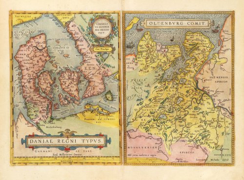
Daniae Regni Typus Cornelius Antoniades Descripsit; [On sheet with:] Oldenburg Comit.
Item Number: 29133 Authenticity Guarantee
Category: Antique maps > Europe > Northern Europe
Old, antique map: two maps on one sheet by A. Ortelius: Denmark and Oldenburg.
Title: Daniae Regni Typus Cornelius Antoniades Descripsit; [On sheet with:] Oldenburg Comit.
Cornelius Antoniades descripsit.
Cum privilegio.
Cartographer: Cornelis Anthoniszoon (for Denmark).
Date of the first edition: 1584.
Date of this map: 1584.
Copper engraving, printed on paper.
Map size: 345 x 490mm (13.58 x 19.29 inches).
Sheet size: 420 x 540mm (16.54 x 21.26 inches).
Verso: Latin text.
Condition: Original coloured, excellent.
Condition Rating: A+.
From: Theatrum Orbis Terrarum. Antwerp, Christoffel Plantin, 1584. (Van der Krogt, 31:031)
Abraham Ortelius (1527-1598)
The maker of the 'first atlas', the Theatrum Orbis Terrarum (1570), was born on 4 April 1527 into an old Antwerp family. He learned Latin and studied Greek and mathematics.
Abraham and his sisters, Anne and Elizabeth, took up map colouring. Ortelius was admitted to the Guild of St. Luke as an "illuminator of maps." In addition to colouring maps, Ortelius was a dealer in antiques, coins, maps, and books, and the book and map trade gradually became his primary occupation.
Business went well because his means allowed him to amass an extensive collection of medals, coins, and antiques, as well as a library of many volumes. In addition, he travelled extensively, visited Italy and France, made contacts with scholars and editors everywhere, and maintained extensive correspondence with them.
In 1564, he published his first map, a large and ambitious world wall map. The inspiration for this map may well have been Gastaldi's large world map. In 1565, he published a map of Egypt and a map of the Holy Land; a large map of Asia followed.
In 1568, the production of individual maps for his atlas Theatrum Orbis Terrarum was already in full swing. He completed the atlas in 1569, and in May 1570, it was available for sale. It was one of the most expensive books ever published.
This first edition contained seventy maps on fifty-three sheets. Franciscus Hogenberg engraved the maps.
Later editions included Additamenta (additions), resulting in Ortelius' historical atlas, the Parergon, which is mainly bound together with the atlas. The Parergon can be considered a truly original work by Ortelius, who drew the maps based on his research.
The importance of the Theatrum Orbis Terrarum for geographical knowledge in the last quarter of the sixteenth century is difficult to overemphasise. Nothing was like it until Mercator's atlas appeared twenty-five years later. Demand for the Theatrum was remarkable. Some 24 editions appeared during Ortelius's lifetime, and another 10 after he died in 1598. Editions were published in Dutch, German, French, Spanish, English, and Italian. The number of map sheets grew from 53 in 1570 to 167 in the last edition in 1612.
In 1577, engraver Philip Galle and poet-translator Pieter Heyns published the first pocket-sized edition of the Theatrum, the Epitome. The work was trendy. Over thirty editions of this Epitome were published in different languages.
Ortelius is also remembered for an early idea resembling continental drift: he suggested that the Americas, Europe, and Africa may once have been joined together before separating over time. His work helped shape the development of modern geography and mapmaking.
Related items

Iutiae Tabula in qua sunt Dioecesis Alburgensis, Wiburgensis, Ripensis et Arhusiensis quae et sunt divisae in Omnia Dominia. c. 1680
Denmark - Jutland, by F. De Wit.
[Item number: 2669]

Paskaart vande West Kust van Jutland van Busem tot aen 't Jutsche Riff met Alle syn Eylanden daer onder Begrepen. 1697-1709
Sea chart of Denmark (Westcoast of Jutland), by J. Van Keulen.
[Item number: 13449]

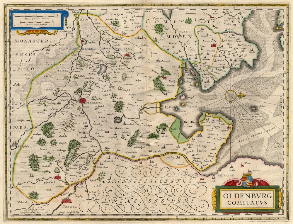
Oldenburg Comitatus c. 1680
Oldenburg, by F. de Wit.
[Item number: 13774]

Thietmarsiae, Holsaticae Regionis Partis Typus. - Oldenburg Comit. 1612
Dithmarschen - Oldenburg, by Abraham Ortelius.
[Item number: 18704]
Oldenburg Comitatus. 1647-50
Oldenburg, by Blaeu W.
[Item number: 18909]

Westfalia Cum Dioecesi Bremensi 1595
Ost-Friesland, Oldenburg, and Bremen by Gerard Mercator.
[Item number: 19091]

Carte de l'Etat du Royaume de Dannemarck et diverses observations pour conduire à l'Intelligence de l'Histoire et du Gouvernement de ce Royaume. 1714
Denmark - Copenhagen, by Zacharias Châtelain.
[Item number: 21339]
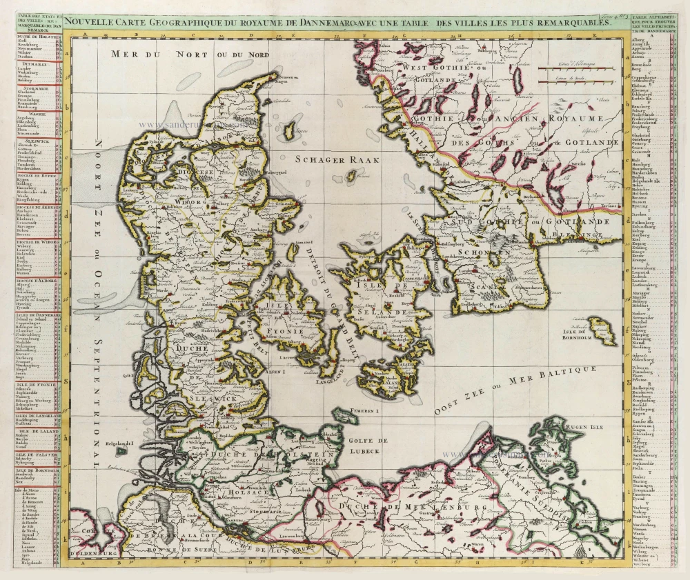
Nouvelle Carte Géographique du Royaume de Dannemarck avec une Table des Villes les plus remarquables. 1714
Denmark, by Zacharias Châtelain.
[Item number: 21341]

Le Royaume de Danemark Subdivisé en ses Principales Provinces. 1710
Denmark by Sanson - Covens & Mortier.
[Item number: 23736]

Iutiae Tabula in qua sunt Dioecesis Alburgensis, Wiburgensis, Ripensis et Arhusiensis quae et sunt divisae in Omnia Dominia. 1721-41
Denmark - Jutland, by Covens & Mortier.
[Item number: 23738]

Insularum Danicarum ut Zee-Landiae, Fioniae, Langelandiae, Lalandiae, Falstriae, Fembriae, Mona aliarumq in Mari Balthico Sitar Descriptio. c. 1682-86
Danish Islands by de Wit F.
[Item number: 24504]

Dania Regnum. 1649-55
Denmark, by W. & J. Blaeu.
[Item number: 25266]

Carte du Royaume de Danemarc. 1730
Denmark by Guillaume Delisle, published by Covens & Mortier.
[Item number: 25900]
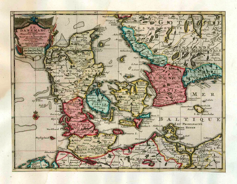
Le Danemarc, Suivant les Nouvelles Observations de Mess.rs de L'Academie Royale des Sciences, etc. 1713
Denmark, by Pieter van der Aa
[Item number: 26044]

Emden & Oldenborch Comit. 1623
Emden - Oldenburg, by Gerard Mercator.
[Item number: 28134]

Dania Regnum In quo sunt Ducatus Holsatia et Slesvicum Iutia, et Insulae, dictae Danicae, quae Nuncupantur Zelandia, Fionia, Lalandia, Falstria, Langelandia Bornholmia etc. after 1721
Denmark by Frederik de Wit, published by Covens & Mortier.
[Item number: 28268]

Regni Daniae, Novißima at Accuratißima Tabula. c. 1678
Denmark by Nicolaes Visscher I.
[Item number: 28521]

Totius Daniae nova descriptio. 1639-42
Denmark by Henricus Hondius.
[Item number: 28699]
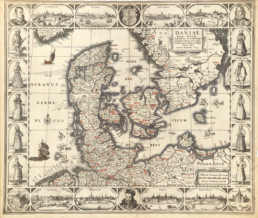
Rare and decorative map from Janssonius' 'Appendix'. Strong impression.
Daniae Regni Typum. 1630
Denmark by Joannes Janssonius.
[Item number: 28950]

Nouvelle Carte Géographique du Royaume de Dannemarck avec une Table des Villes les plus remarquables. 1714
Denmark by Zacharias Châtelain.
[Item number: 29430]

Le Royaume de Danemark, Divisé en ses Provinces. c. 1709
Denmark by Hubert Jaillot.
[Item number: 29589]

Important map
Daniae Regni Typus. 1574
Denmark by Abraham Ortelius.
[Item number: 29601]
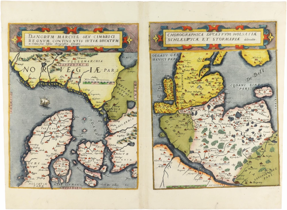
Rare
Danorum Marchiae seu Cimbrici Regnum Continentis Iutiae Ducatum [on sheet with] Chorographica Ducatum Holstatiae Schleswicae et Stormariae 1593
Norway - Denmark by Gerard de Jode
[Item number: 30947]

Le Royaume de Danemark Subdivisé en ses Principales Provinces. 1692
Denmark by N. Sanson, so-called published by Hubert Jaillot. (Pirated edition by Pierre Mortier).
[Item number: 31169]
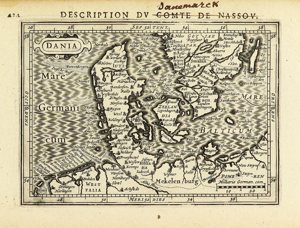
Dania. 1618
Denmark by Petrus Bertius, published by Jodocus Hondius II.
[Item number: 31632]
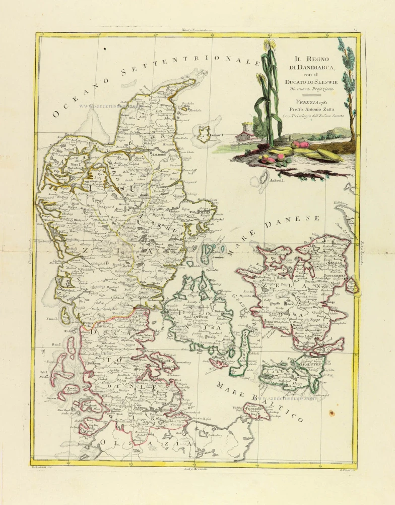
Il Regno di Danimarca, con il Ducato di Sleswik 1779-1785
Denmark, by Antonio Zatta.
[Item number: 31890]

Regni Daniae, in quo sunt Ducatus Holsatia et Slesvicum, Insulae Danicae, Provinciae Iutia Scania Blekingia ec. c. 1720
Denmark, by Homann J.B.
[Item number: 32204]

Scarce
Dania Regnum In quo sunt Ducatus Holsatia et Slesvicum Insulae Danicae et Provinciae Iutia Scania Blekingia et Hallandia. c. 1680
Denmark by Justus Danckerts.
[Item number: 32523]

Important map of the Island of Hven
Topographia Insulae Huenae in Celebri Porthmo Regni Daniae, quem vulgo Oersunt uocant. 1617
Ven by Braun & Hogenberg
[Item number: 32738]

Only in the Atlas Maior. Scarce
Insula Huaena, sive Venusia. 1662
Ven by Joan Blaeu (Hven)
[Item number: 32892]

From the first folio Sea Atlas
Situs Iuttiae una cum ostijs aquarum alitudinibus et vadis omnium eius insularum. - De gelegentheijt van Iutlandt, mits gaders de gaeten, diepten, ende ondiepten, van alle de Iutsche Eijlanden, van Boevenberghen tot dat Eijlandt Silt. 1586
Denmark - Coasts of a part of Jylland between Boulingbjerg and the Island of Sylt, by Lucas Janz. Waghenaer
[Item number: 32933]

Regno di Danimarca. 1687
Denmark, by Guillaume Sanson, published by Giovanni de Rossi.
[Item number: 32958]