
Denmark by Hubert Jaillot. c. 1709


Alexis-Hubert JAILLOT (1632-1712)
A.-H. Jaillot first started as a sculptor. In 1664 he married Jeanne Berey, daughter of the publisher and dealer of prints Nicolas I Berey. Jaillot soon rushed into the print business due to his father-in-law's deaths in 1665 and his brother-in-law in 1667. In 1668, A.-H. Jaillot and his wife acquire the Berey fund's geographical part, which consists of globes, maps, city views and atlases. He becomes the tenant of his father-in-law's shop, Aux Deux Globes, which he buys two years later.
Jaillot enters into an agreement with Guillaume Sanson to publish his maps that will form his Atlas Nouveau's embryo. Sanson undertakes to obtain the privilege for his maps for twenty years and to cede it to Jaillot, as is the custom. Jaillot, for its part, takes care of the engraving, printing and sale of the maps. He engages engravers, François Caumartin and Louis Cordier, to engrave his maps.
A conflict arises between Jaillot and Sanson, and in 1674 it comes to a lawsuit. In 1677 they came back to an agreement.
The Atlas Nouveau first appeared in 1681 and brought great prosperity to his publisher. Jaillot owes him his title of the geographer to the king, awarded on July 20, 1686. He continues to issue maps and signs more and more himself. In 1695, he published the Atlas Français, two-thirds of which are his maps and only one third by Sanson.
A.H. Jaillot dies in 1712 and leaves a vast trading fund.
Le Royaume de Danemark, Divisé en ses Provinces.
Item Number: 29589 Authenticity Guarantee
Category: Antique maps > Europe > Northern Europe
Old, antique map of Denmark by Hubert Jaillot.
Title: Le Royaume de Danemark, Divisé en ses Provinces.
Presenté à Monseigneur le Duc de Bourgogne
Par son très Humble et très Obeissant Serviteur H: Jaillot.
J. Goere delin.
[Second title above map:] Nova Daniae Regni Tabula, ad Usum Serenissimi Burgundiae Ducis Parisius.
Designer: Jan Goeree
Date: c. 1710.
Copper engraving, printed on paper.
Map size: 495 x 605mm (19.49 x 23.82 inches).
Sheet size: 520 x 615mm (20.47 x 24.21 inches).
Verso: Blank
Condition: Original coloured, excellent.
Condition Rating: A+.
From: Dutch Composite Atlas, c. 1710.
Alexis-Hubert JAILLOT (1632-1712)
A.-H. Jaillot first started as a sculptor. In 1664 he married Jeanne Berey, daughter of the publisher and dealer of prints Nicolas I Berey. Jaillot soon rushed into the print business due to his father-in-law's deaths in 1665 and his brother-in-law in 1667. In 1668, A.-H. Jaillot and his wife acquire the Berey fund's geographical part, which consists of globes, maps, city views and atlases. He becomes the tenant of his father-in-law's shop, Aux Deux Globes, which he buys two years later.
Jaillot enters into an agreement with Guillaume Sanson to publish his maps that will form his Atlas Nouveau's embryo. Sanson undertakes to obtain the privilege for his maps for twenty years and to cede it to Jaillot, as is the custom. Jaillot, for its part, takes care of the engraving, printing and sale of the maps. He engages engravers, François Caumartin and Louis Cordier, to engrave his maps.
A conflict arises between Jaillot and Sanson, and in 1674 it comes to a lawsuit. In 1677 they came back to an agreement.
The Atlas Nouveau first appeared in 1681 and brought great prosperity to his publisher. Jaillot owes him his title of the geographer to the king, awarded on July 20, 1686. He continues to issue maps and signs more and more himself. In 1695, he published the Atlas Français, two-thirds of which are his maps and only one third by Sanson.
A.H. Jaillot dies in 1712 and leaves a vast trading fund.
Related items

Paskaart vande West Kust van Jutland van Busem tot aen 't Jutsche Riff met Alle syn Eylanden daer onder Begrepen. 1697-1709
Sea chart of Denmark (Westcoast of Jutland), by J. Van Keulen.
[Item number: 13449]
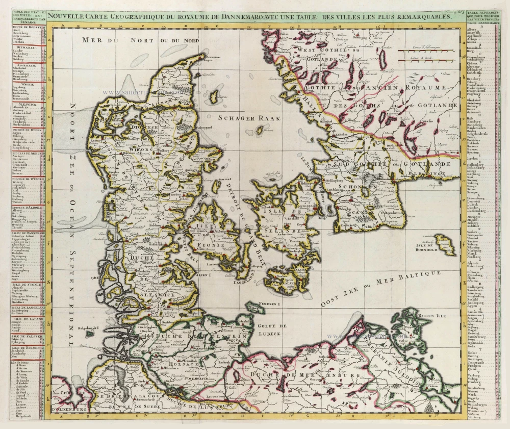
Nouvelle Carte Géographique du Royaume de Dannemarck avec une Table des Villes les plus remarquables. 1714
Denmark, by Zacharias Châtelain.
[Item number: 21341]

Iutiae Tabula in qua sunt Dioecesis Alburgensis, Wiburgensis, Ripensis et Arhusiensis quae et sunt divisae in Omnia Dominia. 1721-41
Denmark - Jutland, by Covens & Mortier.
[Item number: 23738]

Insularum Danicarum ut Zee-Landiae, Fioniae, Langelandiae, Lalandiae, Falstriae, Fembriae, Mona aliarumq in Mari Balthico Sitar Descriptio. c. 1682-86
Danish Islands by de Wit F.
[Item number: 24504]

Dania Regnum. 1649-55
Denmark, by W. & J. Blaeu.
[Item number: 25266]

Carte du Royaume de Danemarc. 1730
Denmark by Guillaume Delisle, published by Covens & Mortier.
[Item number: 25900]
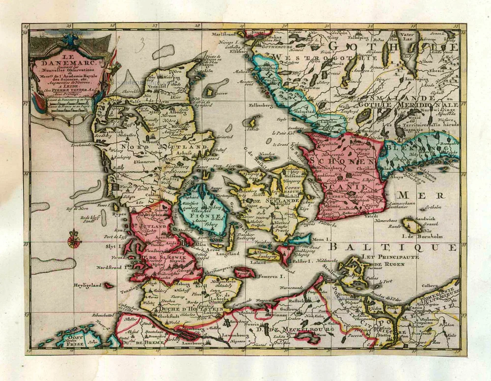
Le Danemarc, Suivant les Nouvelles Observations de Mess.rs de L'Academie Royale des Sciences, etc. 1713
Denmark, by Pieter van der Aa
[Item number: 26044]

Dania Regnum In quo sunt Ducatus Holsatia et Slesvicum Iutia, et Insulae, dictae Danicae, quae Nuncupantur Zelandia, Fionia, Lalandia, Falstria, Langelandia Bornholmia etc. after 1721
Denmark by Frederik de Wit, published by Covens & Mortier.
[Item number: 28268]

Regni Daniae, Novißima at Accuratißima Tabula. c. 1678
Denmark by Nicolaes Visscher I.
[Item number: 28521]

Totius Daniae nova descriptio. 1639-42
Denmark by Henricus Hondius.
[Item number: 28699]
Rare and decorative map from Janssonius' 'Appendix'. Strong impression.
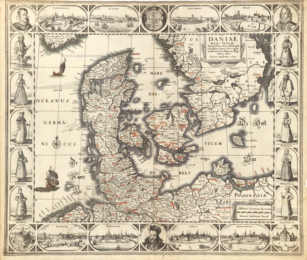
Daniae Regni Typum. 1630
Denmark by Joannes Janssonius.
[Item number: 28950]

Daniae Regni Typus Cornelius Antoniades Descripsit; [On sheet with:] Oldenburg Comit. 1584
Denmark and Jutland by Abraham Ortelius.
[Item number: 29133]

Important map
Daniae Regni Typus. 1574
Denmark by Abraham Ortelius.
[Item number: 29601]

Europae. 1612
Europe, by Abraham Ortelius.
[Item number: 30944]

Rare
Nova Totius Europae Tabula ex magnis Gerardi de Iudaeis P. desumpta 1593
Europe by Cornelis de Jode
[Item number: 30946]
Rare
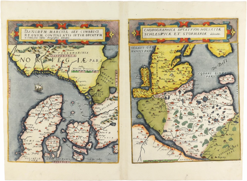
Danorum Marchiae seu Cimbrici Regnum Continentis Iutiae Ducatum [on sheet with] Chorographica Ducatum Holstatiae Schleswicae et Stormariae 1593
Norway - Denmark by Gerard de Jode
[Item number: 30947]

Famous map of Denmark by Marcus Jordan
Danorum Marca, vel Cimbricum, aut Daniae Regnum ... c. 1593
Denmark, by Georg Braun & Frans Hogenberg.
[Item number: 31044]

Le Royaume de Danemark Subdivisé en ses Principales Provinces. 1692
Denmark by N. Sanson, so-called published by Hubert Jaillot. (Pirated edition by Pierre Mortier).
[Item number: 31169]
Dania. 1618
Denmark by Petrus Bertius, published by Jodocus Hondius II.
[Item number: 31632]
Il Regno di Danimarca, con il Ducato di Sleswik 1779-1785
Denmark, by Antonio Zatta.
[Item number: 31890]

Regni Daniae, in quo sunt Ducatus Holsatia et Slesvicum, Insulae Danicae, Provinciae Iutia Scania Blekingia ec. c. 1720
Denmark, by Homann J.B.
[Item number: 32204]

Scarce
Dania Regnum In quo sunt Ducatus Holsatia et Slesvicum Insulae Danicae et Provinciae Iutia Scania Blekingia et Hallandia. c. 1680
Denmark by Justus Danckerts.
[Item number: 32523]

Important map of the Island of Hven
Topographia Insulae Huenae in Celebri Porthmo Regni Daniae, quem vulgo Oersunt uocant. 1617
Ven by Braun & Hogenberg
[Item number: 32738]

Only in the Atlas Maior. Scarce
Insula Huaena, sive Venusia. 1662
Ven by Joan Blaeu (Hven)
[Item number: 32892]

Regno di Danimarca. 1687
Denmark, by Guillaume Sanson, published by Giovanni de Rossi.
[Item number: 32958]