
North Pole by Quad Matthias -Bussemacher J. 1600
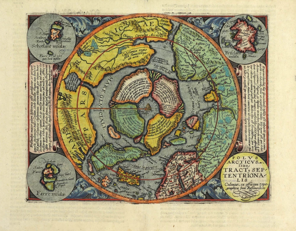


In 1600 Matthias Quad brought out his general atlas of the world. This was largely an expansion of his earlier Europae totius terrarium of 1592. Johannes Bussemacher engraved this attractive map of the North Pole, a reduced version of Gerard Mercator's map of the same first published in 1595. Four main islands surround a large sea at the Pole; these are intersected by four rivers that drain the world's oceans.
Matthias Quad (Deventer, 1557 – Eppingen, 1613)
Matthias Quad, born in Deventer in 1557, was trained there as an engraver by the Van Deutecum brothers. He also studied with Hendrick Goltzius in Haarlem. Later, he settled in Germany after spending some time in France and England.
He lived in Cologne since 1587, where he met the renowned engraver and mapmaker Frans Hogenberg and the printer and publisher Johann Bussemacher. For the next 15 years, Quad worked closely with Bussemacher, especially in publishing atlases. In 1592 he published a translation of an atlas by Botero, and in the following years, several geographical works followed.
With Bussemacher, he prepared a hand and travel atlas in a small format for which he mainly took engraving to heart. From 1592, they published some editions under the name of Bussemacher without text. In 1594 appeared the Europae … descriptio as an atlas with 50 maps with text by Quad. Bussemacher printed the maps, but the text was printed by Lambert Andreae, with whom Bussemacher often collaborated. In 1600 followed the Geographisch Handtbuch, a world atlas with 82 maps.
From that time on, Quad releases a series of Itineraries. The Deliciae Germaniae (1600), the Deliciae Galliae (1600), the Itinearium universae Germaniae (1602), and others on Northern Europe, Italy and Spain.
He spent the last years of his life as a teacher in Eppingen, where he died in 1613.
Johann Bussemacher (florished 1580-1613)
Johann Bussemacher was a German engraver, publisher, printer and art dealer. Beginning in the 17th century, he was the most successful publisher in Cologne.
Polus Arcticus sive Tract, Septentrionalis.
Item Number: 29465 Authenticity Guarantee
Category: Antique maps > Europe > Northern Europe
Old, antique map of the North Pole by Matthias Quad.
With inset maps of the Faeroe Islands, the Shetland Isles and the mythical island of Frisland.
Title: Polus Arcticus sive Tract, Septentrionalis.
Coloniae, ex officina typographica Jan Bussemechers.
Engraver: J. Bussemacher.
Date of the first edition: 1600.
Date of this map: 1600.
Copper engraving, printed on paper.
Map size: 215 x 275mm (8.46 x 10.83 inches).
Sheet size: 270 x 350mm (10.63 x 13.78 inches).
Verso: German text.
Condition: Original coloured, excellent.
Condition Rating: A+.
From: Geographisch Handtbuch. Cologne, J. Bussemacher, 1600. (Meurer (Cologne), Qua 6)
In 1600 Matthias Quad brought out his general atlas of the world. This was largely an expansion of his earlier Europae totius terrarium of 1592. Johannes Bussemacher engraved this attractive map of the North Pole, a reduced version of Gerard Mercator's map of the same first published in 1595. Four main islands surround a large sea at the Pole; these are intersected by four rivers that drain the world's oceans.
Matthias Quad (Deventer, 1557 – Eppingen, 1613)
Matthias Quad, born in Deventer in 1557, was trained there as an engraver by the Van Deutecum brothers. He also studied with Hendrick Goltzius in Haarlem. Later, he settled in Germany after spending some time in France and England.
He lived in Cologne since 1587, where he met the renowned engraver and mapmaker Frans Hogenberg and the printer and publisher Johann Bussemacher. For the next 15 years, Quad worked closely with Bussemacher, especially in publishing atlases. In 1592 he published a translation of an atlas by Botero, and in the following years, several geographical works followed.
With Bussemacher, he prepared a hand and travel atlas in a small format for which he mainly took engraving to heart. From 1592, they published some editions under the name of Bussemacher without text. In 1594 appeared the Europae … descriptio as an atlas with 50 maps with text by Quad. Bussemacher printed the maps, but the text was printed by Lambert Andreae, with whom Bussemacher often collaborated. In 1600 followed the Geographisch Handtbuch, a world atlas with 82 maps.
From that time on, Quad releases a series of Itineraries. The Deliciae Germaniae (1600), the Deliciae Galliae (1600), the Itinearium universae Germaniae (1602), and others on Northern Europe, Italy and Spain.
He spent the last years of his life as a teacher in Eppingen, where he died in 1613.
Johann Bussemacher (florished 1580-1613)
Johann Bussemacher was a German engraver, publisher, printer and art dealer. Beginning in the 17th century, he was the most successful publisher in Cologne.