
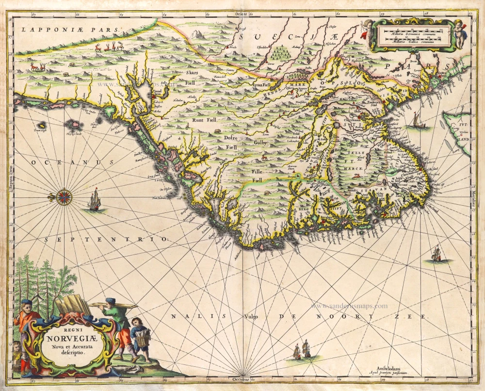
Norway by F. de Wit - R. & J. Ottens. After 1721

Frederick de Wit (1630-1706)
The engraver and map-seller, Frederick de Wit, was born in Gouda (Netherlands) in 1630 as a son of Hendrick Fredericksz de Wit. Through his marriage with Maria van der Waag of Amsterdam in 1661, he obtained citizenship of the city where he had been working since 1648 and where he became one of the most famous engravers of maps of the second half of the 17th century. Although De Wit was a Catholic, which meant that he was not favoured at the time by the city council, he was awarded the honour of being listed as one of the "excellent citizens" on the roll of the city council in the years 1694-1704. However, his name was not written in the Guild of St. Luke book before 1664. At that time, he lived on the Kalverstraat "in de Witte Pascaert", where he stayed until his death in 1706. His earliest dates on maps engraved are 1659 (Regni Daniae) and 1660 (World map).
Frederick de Wit published several world atlases, a sea atlas, and an atlas of the Netherlands.
The dating of the maps is difficult. However, as a privilege was granted in 1689, the annotation 'cum privilegio' marks an edition after 1688.
Around 1700, Frederick de Wit entered the market with a town atlas. He produced two volumes with a total of 260 plans and views. Most were printed from plates used for Janssonius and Blaeu town atlases.
After he died in 1706, his widow continued the shop until 1709. The plates and stock of De Wit's atlas were sold to Covens & Mortier in 1710, who sold the atlas for an extended period.
The Ottens Family
Joachim Ottens (1663-1719), was a copper-engraver and the founder of the print- and mapsellers’ firm in Amsterdam. In 1710 he became a member of the art- and printsellers guild. After he died in 1719, his widow and the sons continued the business under the name “In de Wereldcaert” (In the world map). On the whole, the Ottens’s financial position was rather weak, and the stock was not very large.
In a notary contract dated 20 October 1726, the partnership between the two brothers, Reinier and Josua, was stipulated. Despite separate shops, the brothers’ partnership continued until the death of Renier in 1750.
After Joshua died in 1765, his widow continued the firm, together with her son, Renier II, until c. 1780.
The firm flourished mainly between 1719 and c. 1750. In that period, they advertised at various times the publication of new maps.
Ottens’s greatest fame comes from the voluminous atlases assembled to order. A small number of these so-called ‘Atlas factice’, splendid copies with gorgeous illumination, have survived. These collector’s copies are known to exist in 2, 6, 8, 11, and even 15 volumes. Ottens also published atlases in one volume, with a varying number of maps, pocket atlases, collections of military plans, and Renard’s atlas de la navigation.
Norvegia Regnum Divisum in suos Dioeceses Nidrosiensem, Bergensem, Opsloensem, et Stavangriensem et Praefecturam Bahusiae ...
Item Number: 23499 Authenticity Guarantee
Category: Antique maps > Europe > Northern Europe
Norway by F. de Wit, published by R. & J. Ottens.
Title: Norvegia Regnum Divisum in suos Dioeceses Nidrosiensem, Bergensem, Opsloensem, et Stavangriensem et Praefecturam Bahusiae ...
Date of the first edition: c. 1688-89.
Date of this map: After 1721.
Copper engraving, printed on paper.
Image size: 585 x 495mm (23.03 x 19.49 inches).
Sheet size: 635 x 515mm (25 x 20.28 inches).
Verso: Blank.
Condition: Old coloured, slight staining along the bottom centrefold.
Condition Rating: A.
From: Atlas minor sive geographia compendiosa in qua orbid terrarum paucis attamen novissimis tablulis ostenditur - Atlas nouveau contenant toutes les parties du monde où sont exactement remarquées les empires, monarchies, royaumes,états, républiques, &c. Amsterdam, R. & J. Ottens (1756). (Koeman, Ott3)
Frederick de Wit (1630-1706)
The engraver and map-seller, Frederick de Wit, was born in Gouda (Netherlands) in 1630 as a son of Hendrick Fredericksz de Wit. Through his marriage with Maria van der Waag of Amsterdam in 1661, he obtained citizenship of the city where he had been working since 1648 and where he became one of the most famous engravers of maps of the second half of the 17th century. Although De Wit was a Catholic, which meant that he was not favoured at the time by the city council, he was awarded the honour of being listed as one of the "excellent citizens" on the roll of the city council in the years 1694-1704. However, his name was not written in the Guild of St. Luke book before 1664. At that time, he lived on the Kalverstraat "in de Witte Pascaert", where he stayed until his death in 1706. His earliest dates on maps engraved are 1659 (Regni Daniae) and 1660 (World map).
Frederick de Wit published several world atlases, a sea atlas, and an atlas of the Netherlands.
The dating of the maps is difficult. However, as a privilege was granted in 1689, the annotation 'cum privilegio' marks an edition after 1688.
Around 1700, Frederick de Wit entered the market with a town atlas. He produced two volumes with a total of 260 plans and views. Most were printed from plates used for Janssonius and Blaeu town atlases.
After he died in 1706, his widow continued the shop until 1709. The plates and stock of De Wit's atlas were sold to Covens & Mortier in 1710, who sold the atlas for an extended period.
The Ottens Family
Joachim Ottens (1663-1719), was a copper-engraver and the founder of the print- and mapsellers’ firm in Amsterdam. In 1710 he became a member of the art- and printsellers guild. After he died in 1719, his widow and the sons continued the business under the name “In de Wereldcaert” (In the world map). On the whole, the Ottens’s financial position was rather weak, and the stock was not very large.
In a notary contract dated 20 October 1726, the partnership between the two brothers, Reinier and Josua, was stipulated. Despite separate shops, the brothers’ partnership continued until the death of Renier in 1750.
After Joshua died in 1765, his widow continued the firm, together with her son, Renier II, until c. 1780.
The firm flourished mainly between 1719 and c. 1750. In that period, they advertised at various times the publication of new maps.
Ottens’s greatest fame comes from the voluminous atlases assembled to order. A small number of these so-called ‘Atlas factice’, splendid copies with gorgeous illumination, have survived. These collector’s copies are known to exist in 2, 6, 8, 11, and even 15 volumes. Ottens also published atlases in one volume, with a varying number of maps, pocket atlases, collections of military plans, and Renard’s atlas de la navigation.
Related items

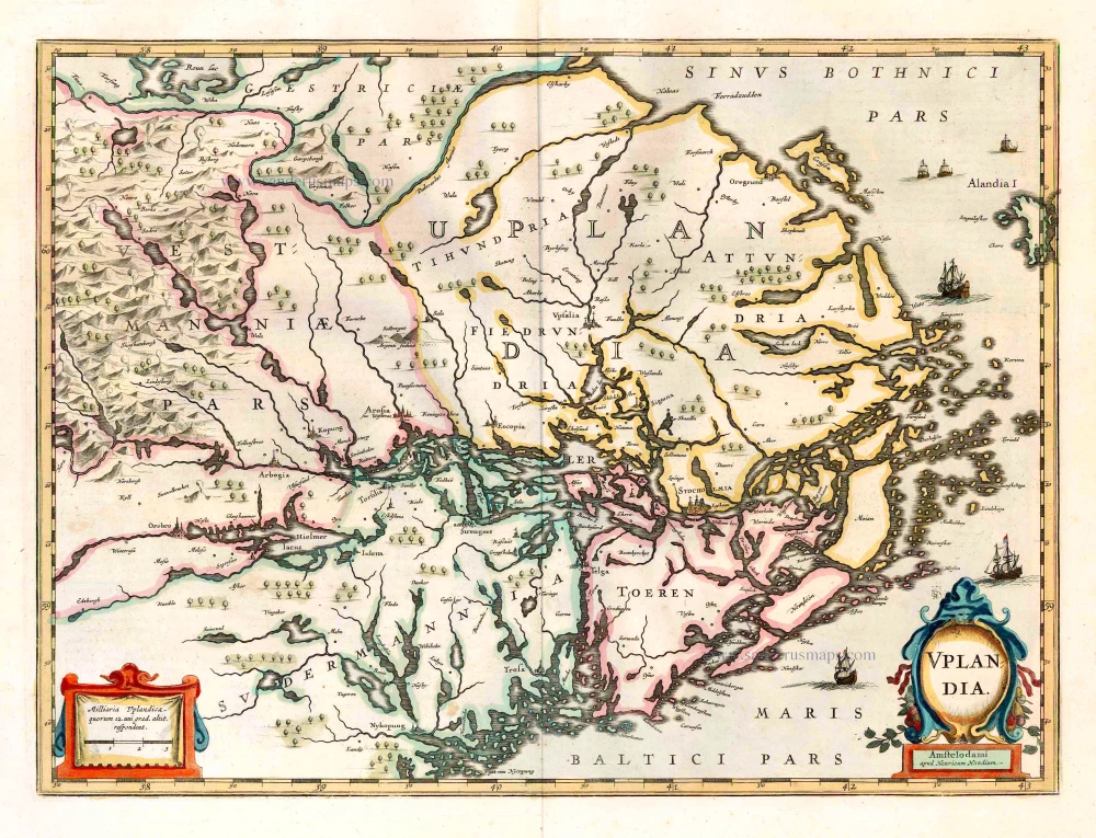
Uplandia 1680
Uppland by J. Janssonius, published by Moses Pitt and J. Janssonius-Waesberge.
[Item number: 1246]

De Custen van Noorwegen en Laplandt, vande Noord-kyn tot aende Rivier van Kola. 1686
Sea chart of the coast of Norway, by Doncker H.
[Item number: 12920]

De Custen van Noorwegen tusschen Der Neus en Schuitenes. 1686
Sea chart of Norway, by Doncker H.
[Item number: 15775]

De Cust van Noorwegen vertoonende van Bergen tot aen de hoek van Horrel. 1686
Norway, by Doncker H.
[Item number: 17064]

De Zee-kusten van Finmarcken tusschen Dronten en Sanien. 1686
Sea chart of Norway - Finnmark, by Doncker H.
[Item number: 17630]

Caarte van Finmargken van 't Eylandt Sanien tot Noordkyn. 1686
Sea chart of Norway - Finnmark, by Doncker H.
[Item number: 17900]

Episcopatus Bergensis 1680
Norway - Bergen, by J. Janssonius, published by Moses Pitt and J. Janssonius-Waesberge.
[Item number: 25068]
Uplandia. 1641
Uppland, by Henricus Hondius.
[Item number: 26261]

Dioecesis Stavangriensis, & partes aliquot vicinae, opera L. Scavenii, S.S. 1643-50
Norway - Stavanger, by Willem & Joan Blaeu.
[Item number: 27100]

Regni Norvegia Nova Tabula in Quinque Praefecturas Generalis Aggerhusiensem, Bergensem, Nidrosiensem, Warhusiae, et Bahusiae. c. 1715
Norway by Frederik de Wit, published by Covens & Mortier.
[Item number: 28266]
Regni Norvegiae. 1666
Norway by Joannes Janssonius.
[Item number: 29724]

Episcopatus Stavangriae Pars Borealis. 1659
Northern Stavanger (Norway) by Joan Blaeu.
[Item number: 30209]
Rare
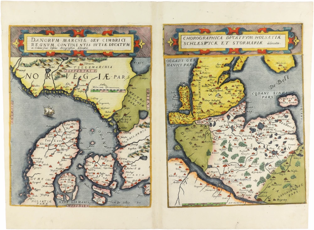
Danorum Marchiae seu Cimbrici Regnum Continentis Iutiae Ducatum [on sheet with] Chorographica Ducatum Holstatiae Schleswicae et Stormariae 1593
Norway - Denmark by Gerard de Jode
[Item number: 30947]

La Norvegia divisa nelle sue Provincie 1779-1785
Norway, by Antonio Zatta.
[Item number: 31892]

Das Konigreich Norwegen. 1789
Norway by F. Reilly.
[Item number: 32186]