This product is successfully added to your cart
Questions about this product? (#4035)

Authenticity Guarantee
All items are guaranteed authentic prints (woodcuts or engravings) or manuscripts made at or about (c.) the given date and in good condition unless stated otherwise. We don’t sell facsimiles or reproductions. We deliver every map with a Certificate of Authenticity containing all the details.

Ptolemy map of Scandinavia, by Marcus Beneventanus. 1507

Claudius Ptolemy (c.100 – c.170 AD)

Claudius Ptolemaeus was a Greek astronomer, mathematician, and geographer who lived in Alexandria during the 2nd century. Much of medieval astronomy and geography were built on his ideas. He was the first to use longitudinal and latitudinal coordinates. This idea of a global coordinates system was highly influential, and we use a similar system today.

Ptolemy wrote several scientific treatises. The first is the astronomical treatise now known as the Almagest, and the second is the Geography, which is a thorough discussion of the geographic knowledge of the Greco-Roman world. The third is the Apotelesmatika, an astrological treatise in which he attempted to adapt horoscopic astrology to the Aristotelian natural philosophy of his day.

The Geographia is a compilation of geographical coordinates of the part of the world known to the Roman Empire during his time. However, the maps in surviving manuscripts of Ptolemy's Geography only date from about 1300, after Maximus Planudes rediscovered the text. It seems likely that the topographical tables are cumulative texts – texts which were altered and added to as new knowledge became available in the centuries after Ptolemy.

The earliest printed edition with engraved maps was produced in Bologna in 1477, followed quickly by a Roman edition in 1478. An edition printed at Ulm in 1482, including woodcut maps, was the first one published north of the Alps.

back

Tabula Moderna Prussie - Livonie Norvegie et Gottie

SOLD

Item Number:  4035 Authenticity Guarantee

Category:  Antique maps > Europe > Northern Europe

Old, antique Ptolemy map of Scandinavia by Marcus Beneventanus

Date of the first edition: 1507
Date of this map: 1507

Copper engraving, printed on two sheets, joined.
Size along top: 31.5 x 32cm (12.3 x 12.5 inches); at bottom: 31.5 x 57cm (12.3 x 22.1 inches)
Verso: Blank
Condition: Some creasing and wear in the centre, vertical fold at 35mm from the right edge.
Condition Rating: B
References: Ginsberg (Scandinavia), 4.

From: In hoc Operae Haec Contine[n]tur Geographia Cl. Ptholemaei ... Rome, Bernardinus Venetus de Vitalibus, 1507.

This map was one of the 6 additional maps added to the 27 traditional Ptolemaic maps. It is a copy of the Ulm Scandinavia map, but is here engraved on copper for the first time.
Beneventanus, together with Joannes Cota of Verona, also revised and edited for this 1507 edition the Latin translation of Jacobus Angelus.

Claudius Ptolemy (c.100 – c.170 AD)

Claudius Ptolemaeus was a Greek astronomer, mathematician, and geographer who lived in Alexandria during the 2nd century. Much of medieval astronomy and geography were built on his ideas. He was the first to use longitudinal and latitudinal coordinates. This idea of a global coordinates system was highly influential, and we use a similar system today.

Ptolemy wrote several scientific treatises. The first is the astronomical treatise now known as the Almagest, and the second is the Geography, which is a thorough discussion of the geographic knowledge of the Greco-Roman world. The third is the Apotelesmatika, an astrological treatise in which he attempted to adapt horoscopic astrology to the Aristotelian natural philosophy of his day.

The Geographia is a compilation of geographical coordinates of the part of the world known to the Roman Empire during his time. However, the maps in surviving manuscripts of Ptolemy's Geography only date from about 1300, after Maximus Planudes rediscovered the text. It seems likely that the topographical tables are cumulative texts – texts which were altered and added to as new knowledge became available in the centuries after Ptolemy.

The earliest printed edition with engraved maps was produced in Bologna in 1477, followed quickly by a Roman edition in 1478. An edition printed at Ulm in 1482, including woodcut maps, was the first one published north of the Alps.

References: Ginsberg (Scandinavia) - 4

Related items

Russia - Nassau Strait, by J. Blaeu.

Fretum Nassovium Vulgo De Straet Nassou. 1664-65
Russia - Nassau Strait, by J. Blaeu.
[Item number: 14225]

€440  ($466.4 / £374)
SCANDINAVIA by Schenk P.

La Scandinavie, et les Environs, ou sont les Royaumes de Suede, de Danemark et de Norwege, divises en leurs principales Provinces. c. 1700
SCANDINAVIA by Schenk P.
[Item number: 19145]

€420  ($445.2 / £357)
Finland, Sweden, Latvia, by Valk G. & L. - Ottens R. & I.

Sueciae Magnae, totius Orbis Regniantiquissimi, hodierna in sex Principales suas partes, Gothiam nempe, Sueciam propriam sive stricté Sumptam, Nordlandiam, Finniam, Ingriam, Livoniam, ... c. 1745
Finland, Sweden, Latvia, by Valk G. & L. - Ottens R. & I.
[Item number: 25846]

€350  ($371 / £297.5)
Scandinavia par R. & I. Ottens.

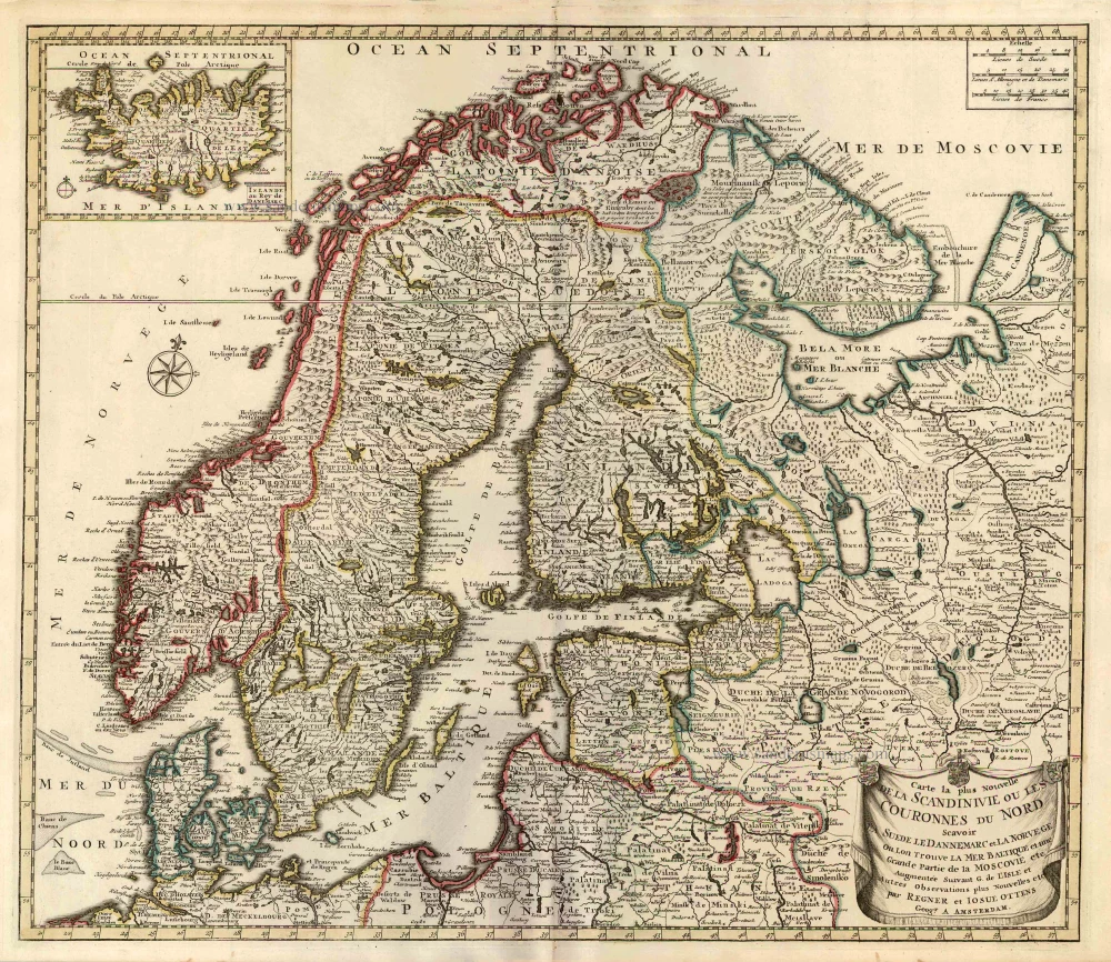
Carte la Plus Nouvelle de la Scandinivie ou les Couronnes du Nord Scavoir La Suede le Dannemarc et La Norvege Ou Lon Trouve La Mer Baltique et une Grande Partie de la Moscovie etc. 1730-45
Scandinavia par R. & I. Ottens.
[Item number: 25858]

€460  ($487.6 / £391)
Scandinavia, by Francesco Santini.

Les Royaumes de Suede et Norwege Divisés par Provinces et Gouvernements. 1776-79
Scandinavia, by Francesco Santini.
[Item number: 26964]

€280  ($296.8 / £238)
Scandinavia, by Michele Tramezini.

Rare and important map.
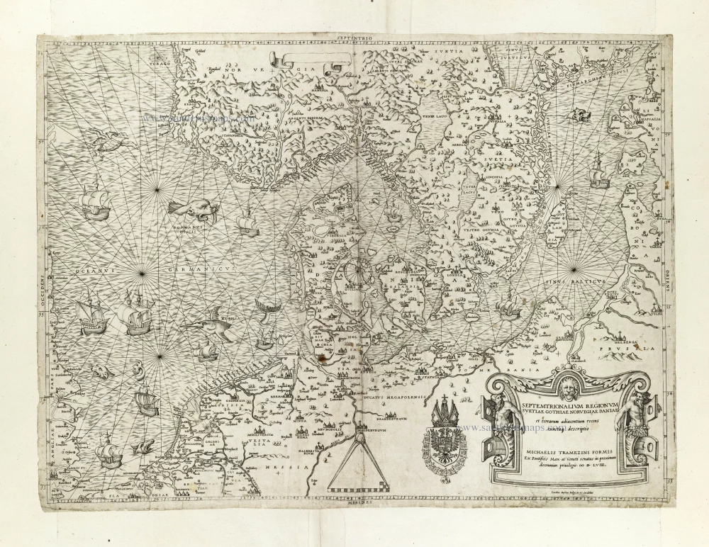
Septemtrionalium Regionum Svetiae Gothiae Norvegiae Daniae et terrarum adiacentium recens exactaq[ue] descriptio. 1558
Scandinavia, by Michele Tramezini.
[Item number: 27045]

€13500  ($14310 / £11475)
Scandinavia by Nicolaas Visscher.

Tabula exactissima Regnorum Sueciae et Norvegiae, nec non Maris Universi Orientalis, 1656-80
Scandinavia by Nicolaas Visscher.
[Item number: 28742]

€450  ($477 / £382.5)
Scandinavia, by Gerard Mercator.

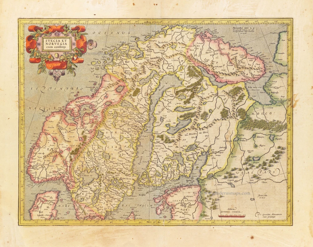
Svecia et Norvegia cum confinijs. 1628
Scandinavia, by Gerard Mercator.
[Item number: 28815]

€760  ($805.6 / £646)
Lappland by Joan Blaeu.

Lapponia. 1659
Lappland by Joan Blaeu.
[Item number: 30252]

€650  ($689 / £552.5)