
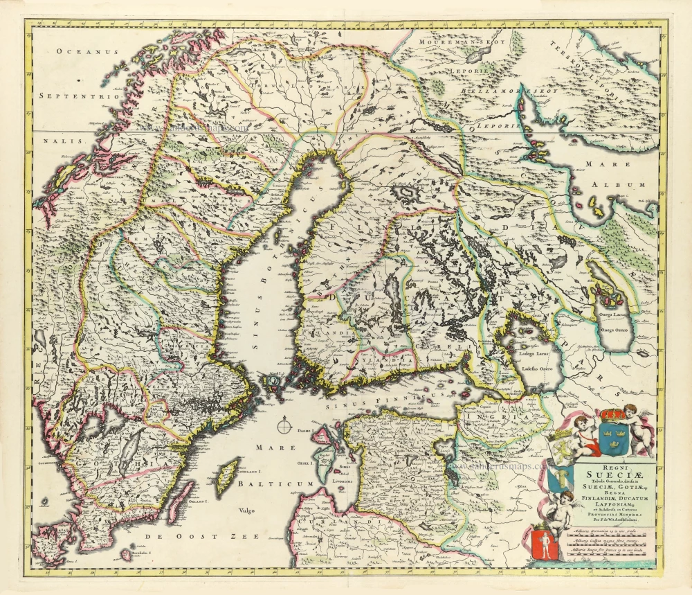
Sweden, by Antonio Zatta. 1779-1785

Antonio Zatta (ca. 1722-1804)
Antonio Zatta was an influential Italian cartographer and publisher based in Venice during the 18th century. As one of the last great mapmakers of the Italian Enlightenment, Zatta played a crucial role in preserving and advancing the art of cartography at a time when Venice's status as a centre for mapmaking was in decline.
Little is known about his early life, but Zatta established himself as a prolific publisher and printer, producing a wide range of works including atlases, city plans, and historical maps. His most celebrated achievement is the Atlante Novissimo, published between 1775 and 1785. This monumental four-volume atlas is considered one of the finest Italian cartographic productions of its time. It combined contemporary geographical knowledge with elegant artistry, featuring detailed hand-coloured maps, elaborate title cartouches, and decorative embellishments characteristic of the late Baroque style.
Zatta’s work is notable for incorporating the latest geographical discoveries alongside classical and historical information, reflecting the Enlightenment's emphasis on reason, exploration, and empirical knowledge. He published maps covering all parts of the known world, including detailed representations of Europe, the Americas, and Asia, often updating older cartographic models with new data from explorers and diplomats.
Among his notable contributions is one of the earliest printed maps depicting the newly independent United States after the American Revolutionary War. Zatta's 1778 map, "Gli Stati Uniti della America Settentrionale," adapted English and French sources, marking a significant moment in the cartographic recognition of the United States.
Antonio Zatta's legacy endures through the beauty and precision of his maps, which continue to be prized by collectors and historians alike for their artistic merit and historical value. His works offer a window into the geographical understanding and visual culture of the 18th century, securing his place among the notable figures of cartographic history.
La Svezia divisa ne suoi Regni
Item Number: 31889 Authenticity Guarantee
Category: Antique maps > Europe > Northern Europe
Sweden & Finland, by Antonio Zatta.
Title: La Svezia divisa ne suoi Regni
di nuova Projezione.
Venezia 1781 | Preßo Antonio Zatta.
Con Privilegio dell' Eccmo Senato.
G. Zuliani inc. G Pitteri scr.
Engraver: Giuliano Zuliani & Giovanni Pitteri.
Date of the first edition: 1779-1785.
Date of this map: 1779-1785.
Date on map: 1781.
Copper engraving, printed on paper.
Image size: 410 x 310mm (16¼ x 12¼ inches).
Sheet size: 500 x 385mm (19¾ x 15¼ inches).
Verso: Blank.
Condition: Original coloured, excellent.
Condition Rating: A+.
From: Atlante novissimo, illustrato ed accresciuto sulle osservazioni, e scoperte fatte dai più celebri e più recenti geografi, che ora per la prima volta si produce. Venice, Antonio Zatta, 1779-1785.
Antonio Zatta (ca. 1722-1804)
Antonio Zatta was an influential Italian cartographer and publisher based in Venice during the 18th century. As one of the last great mapmakers of the Italian Enlightenment, Zatta played a crucial role in preserving and advancing the art of cartography at a time when Venice's status as a centre for mapmaking was in decline.
Little is known about his early life, but Zatta established himself as a prolific publisher and printer, producing a wide range of works including atlases, city plans, and historical maps. His most celebrated achievement is the Atlante Novissimo, published between 1775 and 1785. This monumental four-volume atlas is considered one of the finest Italian cartographic productions of its time. It combined contemporary geographical knowledge with elegant artistry, featuring detailed hand-coloured maps, elaborate title cartouches, and decorative embellishments characteristic of the late Baroque style.
Zatta’s work is notable for incorporating the latest geographical discoveries alongside classical and historical information, reflecting the Enlightenment's emphasis on reason, exploration, and empirical knowledge. He published maps covering all parts of the known world, including detailed representations of Europe, the Americas, and Asia, often updating older cartographic models with new data from explorers and diplomats.
Among his notable contributions is one of the earliest printed maps depicting the newly independent United States after the American Revolutionary War. Zatta's 1778 map, "Gli Stati Uniti della America Settentrionale," adapted English and French sources, marking a significant moment in the cartographic recognition of the United States.
Antonio Zatta's legacy endures through the beauty and precision of his maps, which continue to be prized by collectors and historians alike for their artistic merit and historical value. His works offer a window into the geographical understanding and visual culture of the 18th century, securing his place among the notable figures of cartographic history.
Related items
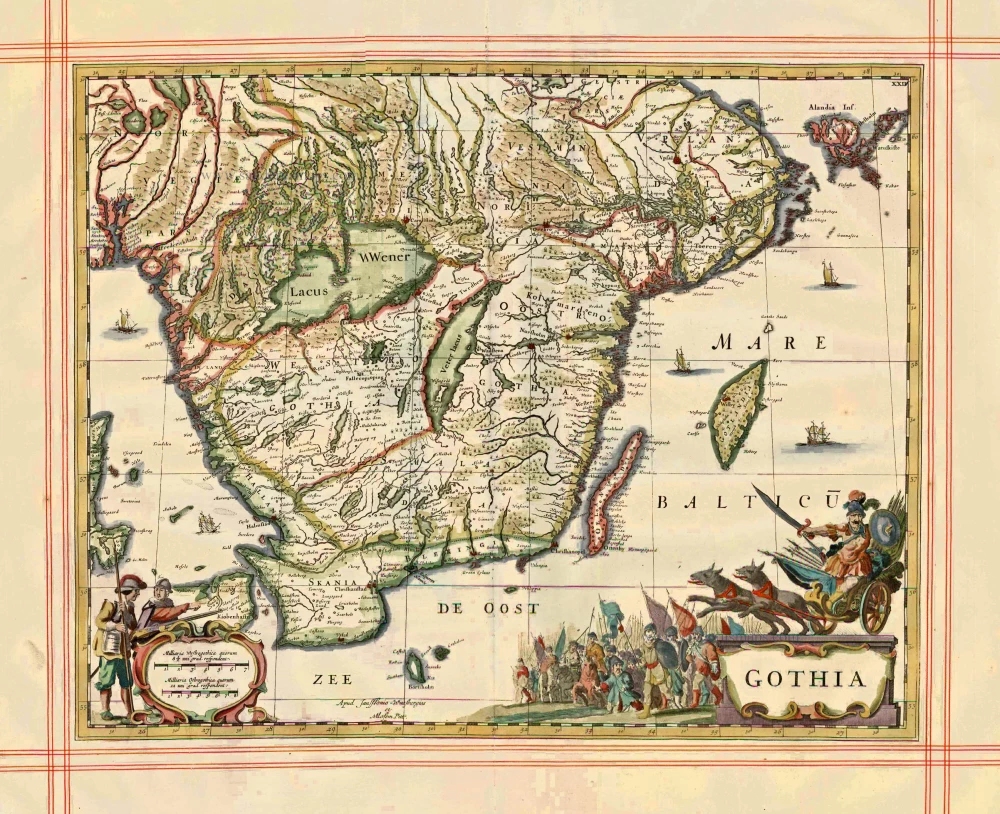
Gothia 1680
Sweden - Götaland, by J. Janssonius, published by Pitt Moses & J. Janssonius-Waesberge.
[Item number: 1290]
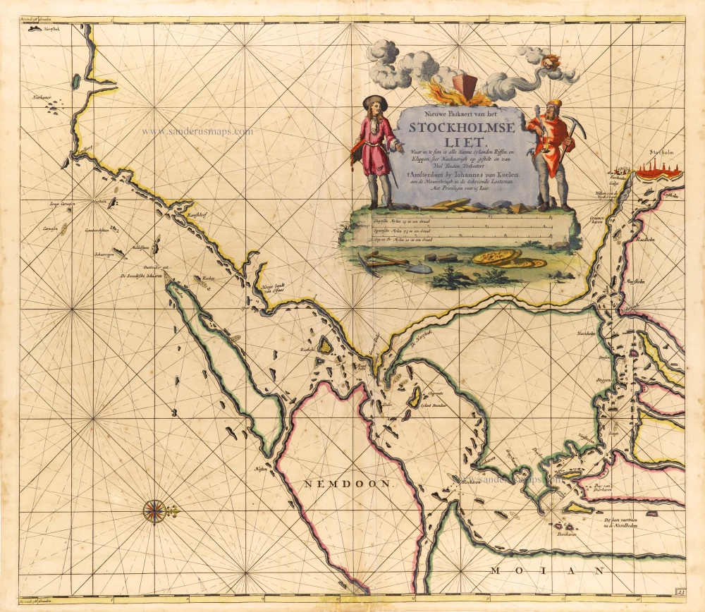
Nieuwe Paskaert van het Stockholmse Liet 1697-1709
Sweden - Stockholm, by Johannes Van Keulen.
[Item number: 12460]

Caarte van 't gat van Abbo, ofte Uttoy. [on sheet with] Caarte van 't Stochomse Liet. 1686
Sea chart of Finland - Sweden, by Doncker H.
[Item number: 14593]
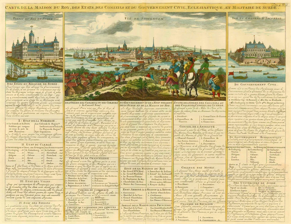
Carte de la Maison du Roy, des Etats, des Conseils et du Gouvernement Civil, Ecclesiastique, et militaire de Suède. 1713-1719
Sweden - Stockholm, by Zacharias Châtelain.
[Item number: 21340]
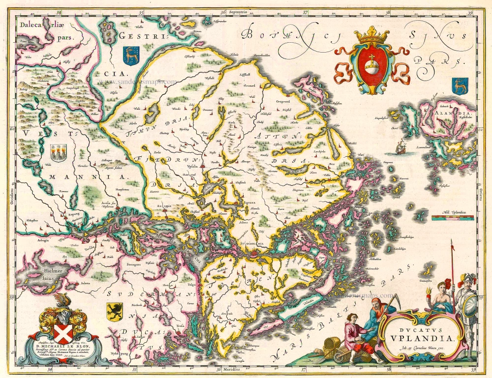
Ducatus Uplandia 1644
Uppland (Sweden), by Joan Blaeu.
[Item number: 21398]

Regni Sueciae Tabula Generalis, divisa in Sueciae, Gotiae Regna Finniae Ducatum Lapponiam, Livoniam Nordlandiam Ingriam et in omnes subiacentes provincias. c. 1715
Finland & Sweden by Frederik de Wit, published by Covens & Mortier.
[Item number: 28267]

First printed map of Finland.
Magnus Ducatus Finlandiae. 1659
Finland by Joan Blaeu.
[Item number: 30242]

Scania Vulgo Schoonen. 1659
Sweden - Skane by Joan Blaeu
[Item number: 30263]

Gothia. 1659
Sweden - Götaland, by Joan Blaeu.
[Item number: 30269]

Sueonia Proprie sic dicta. 1659
Sweden - Svealand, by Joan Blaeu.
[Item number: 31139]
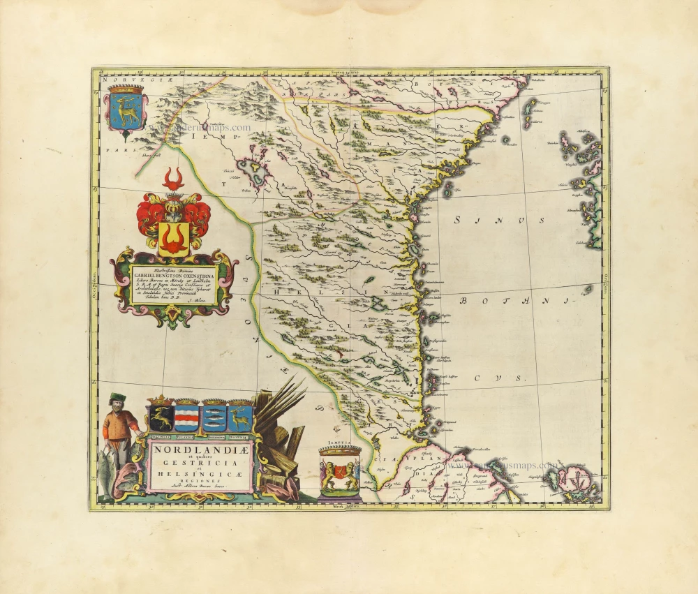
Nordlandiae et quibies Gestricia et Helsingicae 1659
Sweden - Norrland by Blaeu J.
[Item number: 32436]
Regni Sueciae Tabula Generalis, divisa in Sueciae, Gotiae Regna Finlandiae Ducatum Lapponiamq. et Subdivisa in Caeteras Provincias Minores. 1682-88
Finland & Sweden by Frederik de Wit.
[Item number: 32614]

Very rare!
Suede. c. 1763
Sweden, 2 playing cards from a set of 14, designed by Nicolas Jean Baptiste de Poilly, printed by Jean-Baptiste Mitoire
[Item number: 33098]
new