
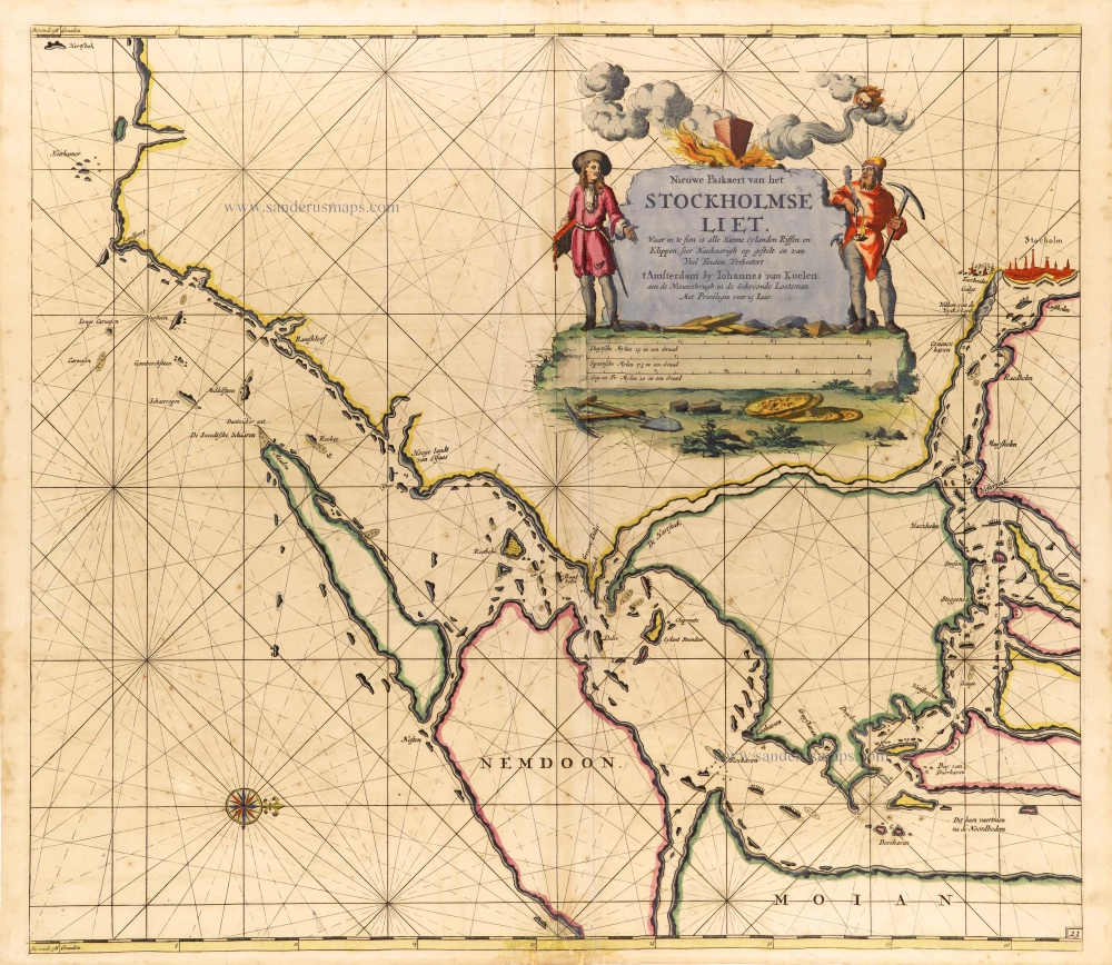
Sweden - Stockholm, by Johannes Van Keulen. 1697-1709
The House of Van Keulen
For more than two centuries, the chart makers firm of Van Keulen was established in the house with the name of “De Gekroonde Lootsman” (The Crowned Pilot). In 1678, the founder of the firm, Johannes I Van Keulen (1634-1689), registered with the Amsterdam booksellers’ guild. He had enlisted the aid of the well-known Mathematical Practitioner Claas Janz Vooght in the preparation of his nautical publications. In 1680 he published the first edition of the Zee-Atlas with 40 charts, all issued for the first time. In the short period of four years, they produced the five volumes of the Nieuwe Groote Ligtende Zee-Fakkel (1681-85). His acquisition of the stock of the bookseller Hendrik Doncker was an essential factor in the development of the firm.
In 1678 a son, Gerard Van Keulen (1678-1726), was born out of Johannes’s first marriage. This son was endowed with talent. He was a skilful engraver and proficient in mathematics and navigational science. Gerard was responsible for establishing the scientific basis of the firm of Van Keulen. In 1714 he was appointed to the office of hydrographer to the Dutch East India Company. The Van Keulens remained chart makers to the East India Company until the Company’s liquidation.
With the introductions to the Zee-Fakkel and Zee-Atlas, Gerard van Keulen gave a new impetus to the firm. Unfortunately, he did not live long, dying when he was 49. The business was carried on by his widow Ludwina Konst. Shortly before Gerard’s death, his son Johannes II had entered the bookseller’s guild, and in 1726 he assumed the management of the firm, though his mother retained her financial interests in the business.
Johannes II Van Keulen (1704-1755) is known in particular for his publication in 1753 of a sixth volume of the Zee-Fakkel, the volume containing the charts of the route to the East Indies.
Johannes II had two sons; they joined the firm as partners in 1757. A considerable number of books appeared in the period 1778-1801. New issues of the Zee-Fakkel again saw the light. The firm flourished under different names until 1885.
Nieuwe Paskaert van het Stockholmse Liet
Item Number: 12460 Authenticity Guarantee
Category: Antique maps > Europe > Northern Europe
Sea chart of Sweden - Stockholm by Van Keulen Johannes.
Title: Nieuwe Paskaert van het Stockholmse Liet
Oriented to the west.
Date: 1697-1709.
Copper engraving, printed on paper.
Image size: 510 x 580mm (20.08 x 22.83 inches).
Sheet size: 530 x 610mm (20.87 x 24.02 inches).
Verso: Blank.
Condition: Original coloured, age-toned, minor spotting.
Condition Rating: B.
From: De Nieuwe Groote Lichtende Zee-Fakkel, ... Amsterdam, J. van Keulen, 1697-1709.
The House of Van Keulen
For more than two centuries, the chart makers firm of Van Keulen was established in the house with the name of “De Gekroonde Lootsman” (The Crowned Pilot). In 1678, the founder of the firm, Johannes I Van Keulen (1634-1689), registered with the Amsterdam booksellers’ guild. He had enlisted the aid of the well-known Mathematical Practitioner Claas Janz Vooght in the preparation of his nautical publications. In 1680 he published the first edition of the Zee-Atlas with 40 charts, all issued for the first time. In the short period of four years, they produced the five volumes of the Nieuwe Groote Ligtende Zee-Fakkel (1681-85). His acquisition of the stock of the bookseller Hendrik Doncker was an essential factor in the development of the firm.
In 1678 a son, Gerard Van Keulen (1678-1726), was born out of Johannes’s first marriage. This son was endowed with talent. He was a skilful engraver and proficient in mathematics and navigational science. Gerard was responsible for establishing the scientific basis of the firm of Van Keulen. In 1714 he was appointed to the office of hydrographer to the Dutch East India Company. The Van Keulens remained chart makers to the East India Company until the Company’s liquidation.
With the introductions to the Zee-Fakkel and Zee-Atlas, Gerard van Keulen gave a new impetus to the firm. Unfortunately, he did not live long, dying when he was 49. The business was carried on by his widow Ludwina Konst. Shortly before Gerard’s death, his son Johannes II had entered the bookseller’s guild, and in 1726 he assumed the management of the firm, though his mother retained her financial interests in the business.
Johannes II Van Keulen (1704-1755) is known in particular for his publication in 1753 of a sixth volume of the Zee-Fakkel, the volume containing the charts of the route to the East Indies.
Johannes II had two sons; they joined the firm as partners in 1757. A considerable number of books appeared in the period 1778-1801. New issues of the Zee-Fakkel again saw the light. The firm flourished under different names until 1885.
Related items
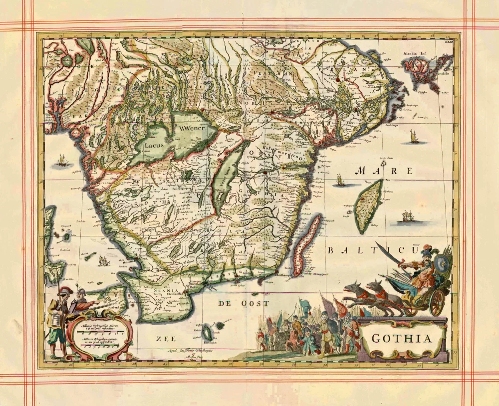
Gothia 1680
Sweden - Götaland, by J. Janssonius, published by Pitt Moses & J. Janssonius-Waesberge.
[Item number: 1290]
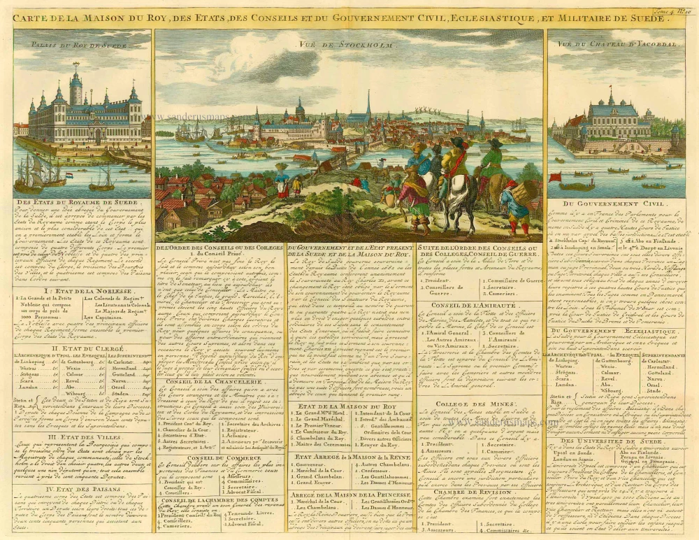
Carte de la Maison du Roy, des Etats, des Conseils et du Gouvernement Civil, Ecclesiastique, et militaire de Suède. 1713-1719
Sweden - Stockholm, by Zacharias Châtelain.
[Item number: 21340]
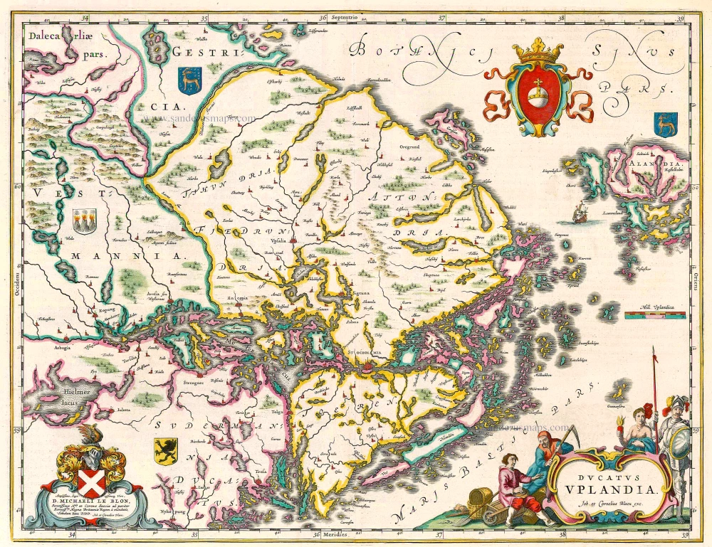
Ducatus Uplandia 1644
Uppland (Sweden), by Joan Blaeu.
[Item number: 21398]
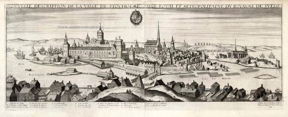
Nouvelle Description de la Ville de Stockholme Siege Royal et Metropolitaine du Royaume de Suede. 1648
Stockholm by Jean Boisseau
[Item number: 25690]

Scania Vulgo Schoonen. 1659
Sweden - Skane by Joan Blaeu
[Item number: 30263]

Unrecorded variant of Allard's view of Stockholm
Stockholm. 1673
View of Stockholm by Carel Allard.
[Item number: 30555]

First edition
Stockholm. 1588
Stockholm, by Georg Braun and Frans Hogenberg.
[Item number: 30937]

Sueonia Proprie sic dicta. 1659
Sweden - Svealand, by Joan Blaeu.
[Item number: 31139]

Rare
Stokholm - Stocholmia totius Suetia metropolis, est admodum coelebris ... c. 1678
Gerard Jollain, Stockholm panoramic view
[Item number: 31340]
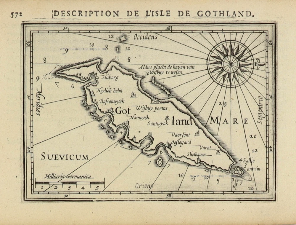
Gotland. 1618
Gotland (Swedish island) by Petrus Bertius, published by Jodocus Hondius II.
[Item number: 31857]

La Svezia divisa ne suoi Regni 1779-1785
Sweden, by Antonio Zatta.
[Item number: 31889]
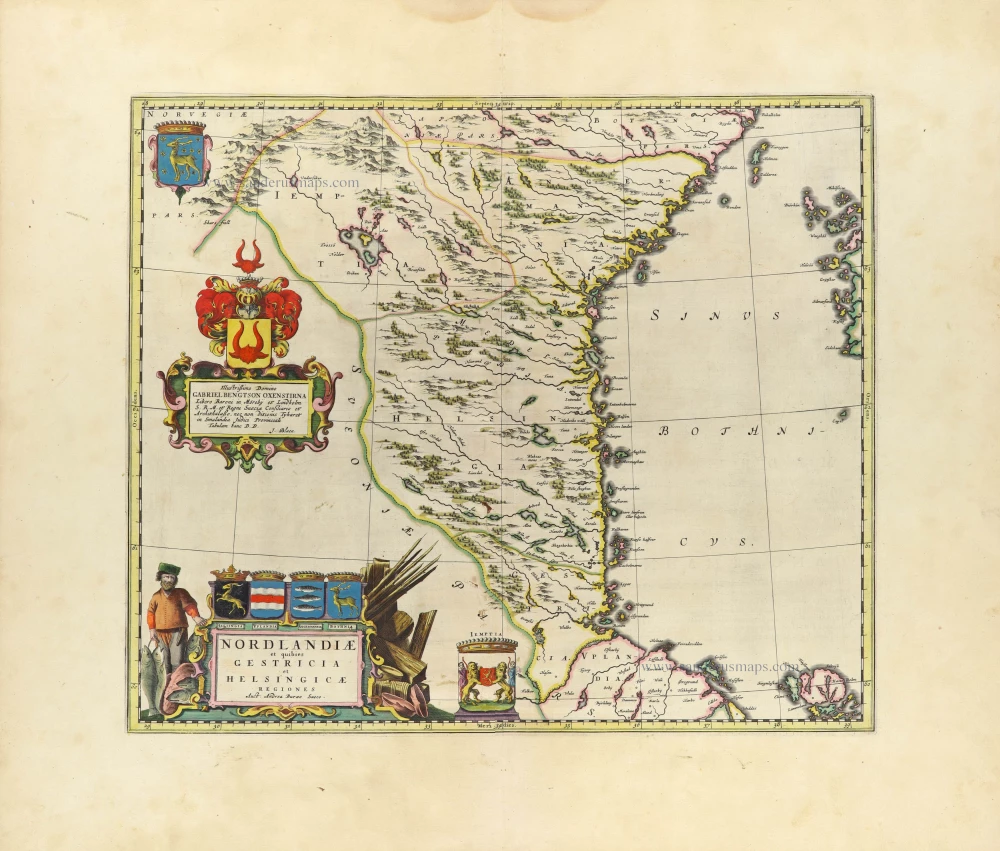
Nordlandiae et quibies Gestricia et Helsingicae 1659
Sweden - Norrland by Blaeu J.
[Item number: 32436]

Very rare!
Suede. c. 1763
Sweden, 2 playing cards from a set of 14, designed by Nicolas Jean Baptiste de Poilly, printed by Jean-Baptiste Mitoire
[Item number: 33098]
new
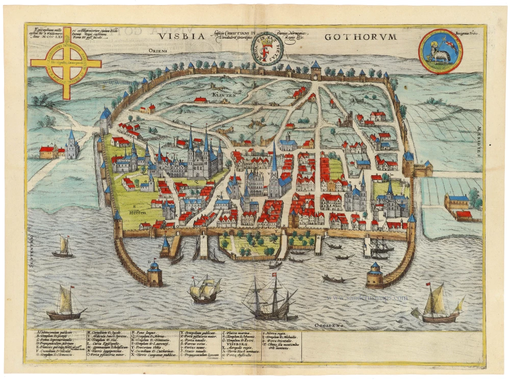
Visbia Gothorum 1596
Visby by Braun & Hogenberg
[Item number: 33197]
new