
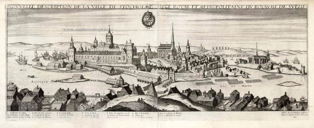
Stockholm by Jean Boisseau 1648
Jean Boisseau (flourished 1637-1658)
Jean Boisseau, a prolific map editor, remains somewhat mysterious. He was mentioned for the first time in the Parisian archives in 1631: he was then described as a "master illuminator," a title from which he would never give up. A little later, in 1635, he became a "nautical chart illuminator." Finally, in 1636, he published several heraldry works, genealogy, and chronology.
At the same time, he had a few maps engraved. In 1641 he reissued Jean Leclerc's Theatre and published the Topographie françoise de Châtillon. The following year, he improved Leclerc's atlas, which became his own Théatre des Gaules. In 1643, he copied Mercator-Hondius' Atlas Minor for his small Trésor des cartes géographiques. Very active until 1648, the date of the publication of the Théatre des Citéz and the second edition of the Topographie.
Boisseau then disappeared without leaving any heirs. Jean Boissevin recovered part of his collection and reissued the Trésor in 1653 and the Topographie in 1655.
Nouvelle Description de la Ville de Stockholme Siege Royal et Metropolitaine du Royaume de Suede.
Item Number: 25690 Authenticity Guarantee
Category: Antique maps > Europe > Northern Europe
Old antique map - panoramic view of Copenhagen by Jean Boisseau.
With key to locations.
Date of the first edition: 1648
Date of this map: 1648 (= Rare first edition, with the address of Boisseau)
Date on map: 1644
Copper engraving, on two sheets, joined.
Engraver: H. Picart
Size (not including margins): 25.5 x 73.5cm (9.9 x 28.7 inches)
Verso: Blank
Condition: Excellent.
Condition Rating: A+
References: Pastoureau, Boisseau 1, 48.
From: Theatre des Citez, ou Recueil de plusieurs villes, dont les noms suivent par ordre alphabetique; Selon qu'ils sont contenues en ce present volume. Paris, Jean Boisseau, 1648.
Jean Boisseau (flourished 1637-1658)
Jean Boisseau, a prolific map editor, remains somewhat mysterious. He was mentioned for the first time in the Parisian archives in 1631: he was then described as a "master illuminator," a title from which he would never give up. A little later, in 1635, he became a "nautical chart illuminator." Finally, in 1636, he published several heraldry works, genealogy, and chronology.
At the same time, he had a few maps engraved. In 1641 he reissued Jean Leclerc's Theatre and published the Topographie françoise de Châtillon. The following year, he improved Leclerc's atlas, which became his own Théatre des Gaules. In 1643, he copied Mercator-Hondius' Atlas Minor for his small Trésor des cartes géographiques. Very active until 1648, the date of the publication of the Théatre des Citéz and the second edition of the Topographie.
Boisseau then disappeared without leaving any heirs. Jean Boissevin recovered part of his collection and reissued the Trésor in 1653 and the Topographie in 1655.
Related items
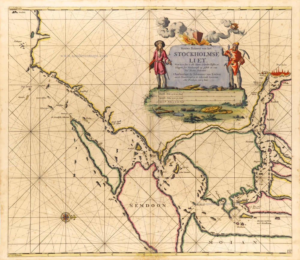
Nieuwe Paskaert van het Stockholmse Liet 1697-1709
Sweden - Stockholm, by Johannes Van Keulen.
[Item number: 12460]
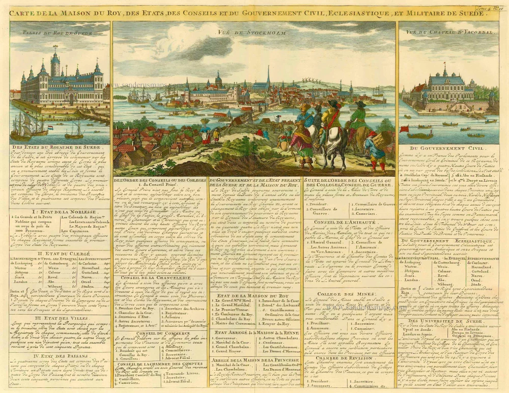
Carte de la Maison du Roy, des Etats, des Conseils et du Gouvernement Civil, Ecclesiastique, et militaire de Suède. 1713-1719
Sweden - Stockholm, by Zacharias Châtelain.
[Item number: 21340]
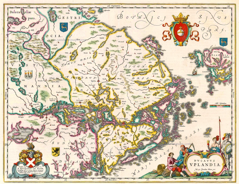
Ducatus Uplandia 1644
Uppland (Sweden), by Joan Blaeu.
[Item number: 21398]

Profil de la Ville de Hafnie vulgairement Copenhagen Cappitalle du Royaume de Danemarck. 1648
Copenhagen, by J. Boisseau.
[Item number: 25597]

Unrecorded variant of Allard's view of Stockholm
Stockholm. 1673
View of Stockholm by Carel Allard.
[Item number: 30555]

First edition
Stockholm. 1588
Stockholm, by Georg Braun and Frans Hogenberg.
[Item number: 30937]

Rare
Stokholm - Stocholmia totius Suetia metropolis, est admodum coelebris ... c. 1678
Gerard Jollain, Stockholm panoramic view
[Item number: 31340]

Helsheborch [on sheet with] Lunden [and] Elbogen [and] Landeskron. 1623
Malmö, Helsingborg, Lund, Landskrona, by Georg Braun & Frans Hogenberg
[Item number: 32923]